| Report Type | Full |
| Peak(s) |
Kilimanjaro - 19344 |
| Date Posted | 03/09/2008 |
| Modified | 03/30/2010 |
| Date Climbed | 02/21/2008 |
| Author | wasclywabbit |
| Kilimanjaro: Machame Route |
|---|
|
Before I start I'd like to thank Aubrey for his excellent Machame Route trip report from last fall as well as taking the time to answer all of my questions via PM. When my good friend Martha and I met a few years back one of the first things we talked about was our mutual desire to climb Kilimanjaro. As is often the case with two busy people we could never get our schedules to coordinate so we kept saying, "some day, some day". 2008 is going to be a milestone year for me because in November I'm going to be cresting the big five-oh. Because of that I recognized that some day better be soon if I wanted to pull this one off. When Martha called me last October and said let's go in February I checked my bank balance, my schedule, my sanity and said let's do it. It wasn't until we actually had booked the plane tickets that I gulped with that queasy sensation that my dad calls "letting your mouth overload your ass". Still I've been hiking for years and had been training for a half marathon in December so I figured that I should be able to pull it off. We shopped around for several weeks trying to select a tour company and in the end we selected Adventures Within Reach which is based out of Boulder. When Aubrey had used them last year they were coordinating with Zara Travel but since then they have started using Eco Tours based out of Tanzania. Ideally we had wanted to use an independent guide who had been recommended to us highly, but his inability to take credit cards along with our desire to have a local company culpable for any problems sealed our decision. We played around with schedule variations and finally decided on a 6 day trek via the Machame Route followed by a 5 day safari. I didn't keep a close accounting of what I spent, but for airfare, the trek, the safari, vaccinations and miscellaneous stuff the total cost was between $6-7000. You can probably pull it off for a bit less, but since there aren't really any deals on airfare to Africa and our trek costs were on the low side for someone booking in the states I don't think a lot less. We have been told that you can go to Tanzania without pre-booking the trek or safari and make arrangements after you arrive for less but we didn't want to take that risk. In any event we were now booked, paid for, vaccinated and terrified waiting for the magic day to arrive. February 14th dawned with a fresh layer of ice on the road and Denver's least competent drivers vying for their place in the transportation hall of shame so we started out in scramble mode trying to get to DIA in time to catch our flight to Detroit, then on to Amsterdam, followed by a leisurely eight hour jaunt to Kilimanjaro Airport in Tanzania. You have more choices in airlines if you fly through Nairobi but the hassles getting to Tanzania from there didn't seem worth it. After 30+ total hours hurtling through the sky in an aluminum tube while trying to fight off the cold that I had developed three days before departure, we finally arrived in Moshi under a cloudy sky that was trying desperately to conceal a rapidly ripening moon. We were greeted by Phillip one of the owners of Eco Tours at the Keys Hotel. Phillip was there for almost every transition we had while in Africa and I must say he did an exceptional job of making us feel welcome. We stayed two nights at the Keys in Moshi in order to allow us time to get over our jetlag and get a feel for the area. I would highly recommend both the Keys as well as scheduling the extra day. Since we had arrived at night we still hadn't seen the mountain so the next morning after breakfast I asked the desk clerk if I would be able to see the peak from anywhere near the hotel. They said, "sure, just go out to the road and look right towards the horizon". I did exactly that straining my eyes to pick out this elusive peak. Finally I realized that the shiny white cloud high above me and to the left wasn't a cloud at all, it was a glacier. "Holy Crap", I thought, "that sucker is friggin huge". My conversation with Martha afterwards went something like this; Me; "I have good news and I have bad news". Martha; "What's the good news?" Me; "I saw the mountain." Martha; "What's the bad news?" Me; "I saw the mountain." When you drop into Buena Vista the view of Mt Princeton standing some 6000 feet above the valley floor is spectacular but it's nothing like standing at 2800 feet with your mouth agape looking up at a glacier capped 19,300 foot behemoth. That queasy "mouth overloading ass sensation" was suddenly back with a vengeance. Later that night met our guide Tosha for a briefing and then headed to bed graced with a fitful slumber that often accompanies the start of great adventure. Day 1: The drive to the Machame Gate was relatively uneventful except for the numerous stops along the way for provisions. One stop was supposedly for "beef" but the carcasses hanging in the window were either very small cows or one of the numerous goats that we had seen grazing along the road. (I had beef that night for dinner.....maybe) In any event we began to climb steeply up the ruddy dirt road with the little diesel engine straining to reach its destination without spiking a connecting rod into the mud. At last we reached the gate and tumbled out to join the rest of the dazed trekkers waiting to get started. There was a frenetic buzz in the air as the porters divided up their loads and the eager trekkers had their first of many official sign-ins. 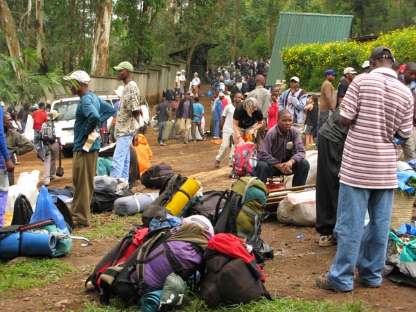 Machame gate. The Machame Gate is situated at: 03 10.439'S, 37 14.230'E and according to my GPS was 5941 feet A.S.L. We started hiking around noon and I immediately noticed the high humidity. Normally I am a heavy sweater even in our semi-arid climate, but here in the jungle I was soon literally soaked to the skin. Keeping hydrated wasn't an issue because I had 6 liters of bottled water in my back, but I was worried about having an electrolyte crash which in fact did happen the next day. Eventually I started adding an electrolyte supplement to my water supply which resolved the problem. The trail to the Machame camp was well maintained, smooth, a bit muddy and not terribly steep. In fact very little of the Machame Route would qualify as steep in my opinion and even then only moderately so. The view was really only of the jungle canopy above with no view of the peak until we reached Machame Camp about 4 hours after leaving the gate. The camp sites were muddy and we got our first experience of the infamous Kilimanjaro outhouses. I won't go into detail but I will say that spending the extra money to have an additional porter haul a port-a-pottie tent would be worth whatever they charged. We heard it was about $50 + tip and had I known in advance what I know now I would have gladly paid that or more. The Machame Camp is located at 03 5.854'S, 37 15.750'E and according to my GPS was 9941 feet A.S.L.  Machame Camp. 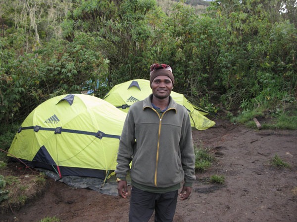 Nasibu. We had our first meal, spent some time getting to know our "waiter" Nasibu and then crashed for the evening. I had to get up in the middle of the night to "dehydrate" and was rewarded with an incredible view of Kibo bathed in the light of a silver satin moon. Day 2: The trek to Shira camp definitely provided a different type of hiking experience than day one did. We were now out of the jungle and had entered the moorland zone. The views were better, the humidity was lower and I was crashing in earnest from my electrolyte depletion of the day before. I had Gatorade in one Nalgene bottle but it wasn't enough. Thankfully Martha had a few packets of some type of electrolyte supplement which finally started kicking in. The trail followed a ridgeline towards the connecting ridge between Shira Peak and Kibo. All in all it was probably the steepest day of the trek but still not what I would call a steep hike. There were quite a few bottlenecks in the narrower sections where I had to practically push my way past a group of obnoxious South Africans who insisted on blocking the trail every few minutes in order to rest. All in all I would say that the Americans were the most polite groups on the mountain while many of the Europeans in addition to the South Africans were just downright rude. One of the porters told me that they all hate getting assigned to German groups because they always want to start at Oh-Dark-Thirty and they never tip. It was nice to finally find someplace in the world where Americans are appreciated.  On the way to Shira Camp. We finally reached Shira Camp after about 5 hours. I decided early on to follow the Pole'- Pole' (Swahili for slowly-slowly) hiking philosophy and enjoy the views while I acclimatized. I'm glad I did because I ended up feeling better at altitude than I thought I would. The Shira Camp is located at: 03 4.209'S, 37 16.284'E and 12,576 feet A.S.L.  Martha at Shira Camp. Mt Meru in the distance.  Kibo from Shira Camp. Day 3: was in many ways the easiest day of the trek. We hit 15K + feet for the first time but the trail was always gentle and on a very soft and forgiving surface. For everyone who suffers knee problems the Machame route both up and down was a delight because very few sections are rocky and tough on the joints. After about an hour of hiking I figured that I was getting close to my personal high point so I switched on my GPS. Sure enough I was at about 14,200 feet and gaining altitude slowly but steadily. Being the geek that I am I just had to mark a waypoint of where I exceeded the elevation of Mt Elbert for the first time. It was interesting to enter it into Google Earth after I got back to get a bird's eye view of where it happened. My new high point was located at: 03 3.935'S, 37 18.305'E and 14,444 feet A.S.L. One thing that wasn't pleasant about the day was the amount of dust in the air. I started coughing with some regularity as I ascended and I wasn't sure if it was the dust, the altitude or the remnants of the cold that I had brought with me from the states. Still at this point I still felt very strong as I ascended up towards the Lava Tower. The Lava Tower trail junction is located at: 03 3.783'S, 37 18.962'E and 14,700 feet A.S.L.  Lava Tower. The Lava Tower is located at: 03 4.256'S, 37 19.434'E and 15,248 feet A.S.L. At the Lava Tower we took a lunch break before descending to the Barranco Camp. Aubrey had raved about the surprisingly clean restrooms at the Lava Tower, I found them to be just somewhat less disgusting than the others. The descent to Barranco Camp went quickly and we were greeted by a view of the imposing Barranco Wall along the way. There were quite a few Giant Groundsels along the trail which give the area a distinctly primeval appearance. I half expected a T-Rex to pop up looking for a dinner of a well fattened American Trekker.  Barranco Wall. We reached camp and had yet another dinner of vegetable something or other and settled in for the night trying to suppress the nightmares about the following day's ascent of the Barranco Wall. Unfortunately the cough that started earlier in the day only got worse through the night, bad enough that I was beginning to get concerned that it might hinder my summit attempt Barranco Camp is located at: 03 5.871'S, 37 19.607'E and 13,102 feet A.S.L. Day 4: dawned with great expectations, another breakfast of porridge (BLECH!), the Barranco Wall looming above us and my now hacking cough to keep me company for the day. This day in many ways is the toughest on the trek and is the start of a day and a half of almost constant motion and very little sleep. The Barranco Wall itself is not nearly as hard as it appears from below but you still need to pay attention as you ascend. Three days previous to our ascent a porter had lost track of the trail and had fallen to his death. The exposure is never that bad and the few easy class 3 moves are all on the lower 1/3 of the wall but you still need to give the wall the respect it deserves. I must say that today more than any other the porters earned my respect as they navigated upwards with full packs as well as a 35lb or heavier duffles balanced on their heads. These guys simply don't make enough money for the job they do. One of the nick names for the Barranco Wall is "The Breakfast Wall" because you've gone through your breakfast and are ready for lunch by the time you top out. It took us about 2 hours to climb the wall and while I wasn't really hungry at that point we went ahead and ate a snack before continuing our journey. The trek beyond the wall looks rather flat but there are quite a few hidden ups and downs along the way that will surprise you when you least expect it. The top of the Barranco Wall is located at: 03 6.130'S, 37 20.013'E and 13,863 feet A.S.L.  Moses near the top of the Barranco Wall.  Kili from the top of the Barranco Wall.  Looking down towards Moshi.  A long day still ahead. Many trekkers opt for a 7 day variation of the Machame Route splitting day four into 2 days with an overnight at the Karanga Camp. The only real advantage I see to this is that it would allow you to get into Barafu Camp early enough to possibly get some sleep before the summit attempt. Also, you would get an extra day to acclimatize which could be helpful for some. Karanga Camp is not a garden spot though and we didn't even stop as we passed through it. Karanga Camp is located at: 03 6.900'S, 37 21.056'E and 13,318 feet A.S.L. We crashed soon after our arrival at Barafu Camp around 4:00 PM. This camp is quite barren and I didn't see any signs of native plant or animal life except for the Kamikaze black and white birds that dive bombed us a time or two. We made plans to get up at 11:00 for tea and then start hiking at 11:30 so that we could reach the crater rim before sunrise. I settled in to try and sleep but by now my cough had journeyed deep into my lungs and had become a primal, heavy cough that shuddered my entire body with every hack. If that wasn't enough the wind began howling across the ridge, easily blowing 40 knots sustained with gusts nearing 60 knots. The vestibule was ripped from Martha's tent and our dinner tent was ripped down as well. Hearing the commotion outside I decided to forgo the summit and stay nestled in my 700 fill goose down paradise. Besides, I figured in those conditions no one else would make a go of it, right? Wrong. Martha was soon up and about and reported that while windy, it wasn't very cold out. She decided to go for it and admonished me to do so as well. She couldn't see me flip her off at that point but suspected that I had done so. She was right. The male ego is a powerful force though and after speaking to Tosha our primary guide I decided to give it a try although I had no expectation of being able to summit considering the way I was feeling at that point. The wind also began to subside a bit so I took that as a good omen and crawled out of my sleeping bag and prepared to go for it. Barafu Camp is located at: 03 5.960'S, 37 22.680'E and 15,305 feet A.S.L. 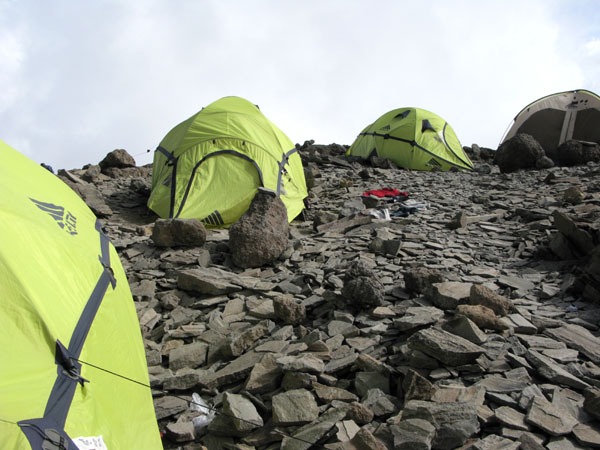 Barafu Camp.  Looking up towards Stella Point. From the beginning of our discussions Martha and I had both wanted to schedule our summit attempt to coincide with a full moon. In this we were not disappointed as the familiar orb bathed the trail in an eerie blue glow complimented by the blue headlamps reaching up into the sky ahead. The respite from the wind however was short-lived as it was soon blowing at a steady 60 knots from right to left. The trail above Barafu is heavily switch-backed so the wind proved to be both a blessing and a curse. Switchbacking to the right you would have to drop your shoulder whilst you battled against the angry wind and his equally insufferable brother gravity. Switchbacking to the left however was far easier in that you could spread your arms like a spinnaker and be carried almost effortlessly to the next switchback. Within an hour of leaving camp we began to see the first casualties of altitude descending with a moribund look of defeat back to camp. I thought I would soon be among them as my cough continued to sap what little strength I had with every hack. Several times I tried to quit but Tosha either couldn't hear me over the wind or he chose not to, instead encouraging me to continue on with a gentle pole' pole'. I must say that even though I was in agony I seemed to be holding my own in the pace department, seldom getting passed and occasionally passing slower groups along the way. About 4:00AM the moon set behind Kili's summit and we were left with just our headlamps for illumination. I could see a long line of lights ahead of me disappearing over Stella Point and even a few coming over from Gillman's point for those who had ascended via the Rongai and Marangu Routes. In the pre-dawn darkness I really couldn't tell how far from Stella point we were but at one point when I looked to my left and saw that I was now higher than the terminus of the Rebman Glacier and for the first time I actually believed I would earn the summit, or at the very least Stella Point. The eastern sky was now growing brighter with every step and about 100 feet below Stella Point I ran into Martha as she began her descent. She looked very surprised to see me and I think that even though she encouraged me to give it a try, I believe that she assumed as I did that my cough would keep me from the summit. Once we reached Stella Point I was prepared to enjoy the sunrise and call it a day. Tosha nodded knowingly and poured me a cup of hot tea from our thermos. After I devoured it he calmly began walking towards Uhuru Point knowing full well that I would suck it up and follow. It is only about ¾ of a mile and a couple hundred feet of elevation gain to Uhuru from Stella but in the driving winds it took nearly 45 minutes to reach the highest point in all of Africa. The views of Rebman Glacier were overwhelming as the ruddy earth of the crater rim contrasted with frozen mass bathed in the sun's early morning warmth. Soon the summit sign came into view and I couldn't help but laugh aloud at the thought of actually pulling it off. Stella Point is located at: 03 4.628'S, 37 21.856'E and 18,652 feet A.S.L.  Mt Mwenzi at sunrise from Stella Point.  Rebman Glacier.  Rebman Glacier. At the summit the winds had not subsided at all and although the temperature wasn't that cold, right around 18 degrees Fahrenheit, the wind-chill began to freeze my hands almost immediately if I removed my gloves. Because of that my time at the summit was very brief, just long enough for a couple of hero shots in front of the famous Uhuru sign and three quick photos of the summit plateau. Uhuru Summit is located at: 03 4.529'S, 37 21.161'E and 19,341 feet A.S.L. 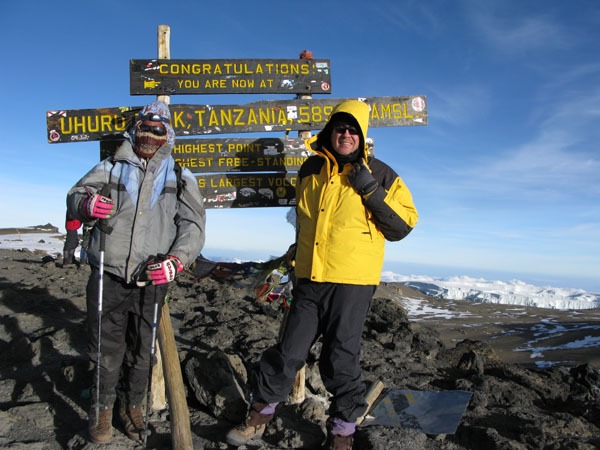 Your's Truly and guide Tosha. The descent back to Barafu was really quick and painless with miles of deep scree to boot ski down without the knee pounding typical of most 14'er descents. We got back to Barafu in a little under 2.5 hours and I dove into my tent with the hope of getting a little sleep before we began our trek down to the final camp, Mweka. There was far too much noise to get any shut-eye though so I finished packing up my gear and began the 5000 foot descent to Mweka. The terrain below Barafu was mostly gentle with soft earth underfoot so my initial fears of the knee busting 9000 foot descent proved to be unfounded. In fact, for the highly motivated you could descend all the way to the park gate the same day as your summit attempt although you would likely be finishing in the dark and would need to have your guide make arrangements in advance to have transportation available upon your arrival. I arrived at camp to the joyous hugs and congratulations of my porters. I suppose they tend to get higher tips if a client summits so that might have had something to do with their delight, but we really tried to get to know these guys on this trek and I think they were truly happy for our accomplishment. Of course my graceful gazelle impersonation as I bounded into camp may have had something to do with their laughter too. Trust me, a 6'5", middle-aged, fat guy has to get very creative to do a graceful gazelle impersonation. Day 6: dawned with the same misty glow that we had greeted day one with, but the porters were especially excited because today was both pay-day and the day they got to go back home to their families. We spread out piles of spare gear near our tents and had carefully counted out the tip money that these guys were so dependant on. We tipped them quite a bit more than the recommended amount and quite frankly even that wasn't nearly enough considering the amount of work they do and the conditions they do it in. They sang the traditional Kilimanjaro song for us and we handed out the tips much to their delight. Hopefully the extra clothes we left will help them stay warm and dry on future treks as well.  Singing the Kilimanjaro song. The final hike out was only about three hours and the mass confusion that greeted us at the Machame Gate was evident here as well. We received our summit certificates and I drank what was possibly the best tasting Coke ever, even if it was room temperature. 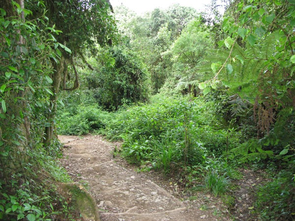 Trail below Mweka Camp. Epilogue: All in all I would have to rank this trip as the most incredible experience of my life. The trek was challenging, the people as friendly and hospitable as any on earth, and the safari was like being inserted into a Doctor Doolittle movie. I would recommend this trip to anyone with a thirst for adventure. Social Commentary: Unfortunately Kilimanjaro is becoming a trash heap like so many of the popular peaks around the world and there is no way to deny that it is we trekkers who are responsible for it. Even though the norm isn't to haul out trash I would suggest that anyone who climbs Kilimanjaro take extra steps to haul out at least what they brought in if not more. The situation with the porters is also disturbing in how they are able to be exploited because of the economic situation in Tanzania. Even though there are minimum wage standards for the porters and guides they are often only assigned treks if they forgo part of their pay or in some case donate it to the guides. Their equipment is substandard or in some cases non-existent (Our assistant guide didn't even have gloves) and they are typically underfed during the trek. The average wage in Tanzania is around $200 per month which often has to support the wage earner as well as their immediate and extended family. If you choose to go to Kilimanjaro please consider taking extra gear to give your porters and guides after the trek, and if at all possible tip generously. Thanks for reading. Thumbnails for uploaded photos (click to open slideshow): ")
")
")
")
")
")
")
")
")
")
")
")
")
")
")
")
")
")
")
")
|
| Comments or Questions | |||||||||||||||||||||||||||||||||
|---|---|---|---|---|---|---|---|---|---|---|---|---|---|---|---|---|---|---|---|---|---|---|---|---|---|---|---|---|---|---|---|---|---|
|
Caution: The information contained in this report may not be accurate and should not be the only resource used in preparation for your climb. Failure to have the necessary experience, physical conditioning, supplies or equipment can result in injury or death. 14ers.com and the author(s) of this report provide no warranties, either express or implied, that the information provided is accurate or reliable. By using the information provided, you agree to indemnify and hold harmless 14ers.com and the report author(s) with respect to any claims and demands against them, including any attorney fees and expenses. Please read the 14ers.com Safety and Disclaimer pages for more information.
Please respect private property: 14ers.com supports the rights of private landowners to determine how and by whom their land will be used. In Colorado, it is your responsibility to determine if land is private and to obtain the appropriate permission before entering the property.


