| Report Type | Full |
| Peak(s) |
Crestone Peak - 14,299 feet Crestone Needle - 14,196 feet Humboldt Peak - 14,068 feet |
| Date Posted | 08/13/2007 |
| Date Climbed | 08/09/2007 |
| Author | thatguy |
| Crestones and Humboldt |
|---|
|
I don't typically write trip reports because I feel like between Bill's amazing route descriptions and the quality write-ups from other users there's really not much for me to add. However, this trip was the first set of hikes where I felt we would elevate ourselves above the casual, weekend-warrior 14er hiker. We've always been careful to say that we 'hike' 14ers, but hopefully after the Crestones, we could start saying that we occasionally 'climb' 14ers. So, this report will be written for those, who like us, are running out of 'easy' routes and need to either shit, or get off the pot, when it comes to finishing all the 14ers. Just a quick background, our previous class 3 experience was Kit Carson, Longs and Wetterhorn. In addition, I had solo'd the sawtooth and Kelso's ridge. Thursday, 8/9 Departed Denver around 11:15 and with stops at REI and lunch, I don't recall exactly how long it took to get to the lower trailhead, but if I had to guess, I'd say 3.5 hours. From the lower trailhead we headed up with our stock Ranger 4x4. The road up to the creak crossing isn't too bad, after that it starts to get a few hard spots. At 3.5 miles we came to a spot where the road crosses a large slab of rock, where ppl either avoid most of it by going left, or go over and across it by going right. At this point, without knowing how much worse it might get we decided to stop there. This was a regrettable decision, as the road isn't bad after that for at least another 0.5 miles or so. But being a one car family, better to err on the side of caution. At the upper trailhead, we saw mostly stock trucks, including a Ranger like ours, F150, Cherokee, and the pretty new Durango. Also, at the trailhead, we met Jen (roozers42) and Melissa who had similar plans as us, which turned out to be a great blessing for us, but more to come on that later. We pushed on for another 1.5 miles or so to get camp set up. Friday, 8/10 We hit the trail at 6 and headed up what we would soon come to hate, Broken Hand Pass. The first 2/3 of the trail is easy enough with all the improvements, and could be done in the dark with just a headlamp. Once it starts its final push up to the pass, it becomes loose and steep, with multiple climber trails leading up. I don't think any one way up seemed any better than another so I'd say pick your way up that seems reasonable. Once we got to the top of the pass and saw the drop into Cottonwood Lake and the start of the Red Gully, we knew coming back up would probably suck. A nicely constructed trail was easy to follow all the way to the entrance point for the gully. From here, you can look up and really see the extent of what you are about to embark on. 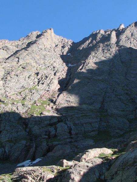 Once in the gully there are intermittent cairns but they don't always make sense to follow. We pretty much took a direct line straight up. There's quite a bit of running water in the lower half but we chose to stay to the left (west) of it. The smooth reddish rock in the lower part of the gully, when dry, is very 'grippy' and can pretty much be walked right up on. 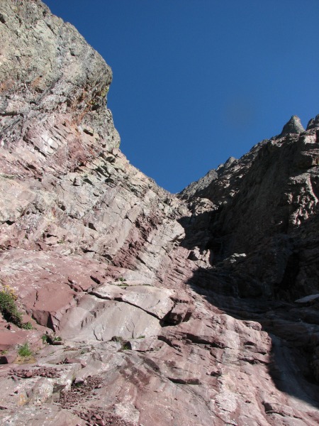 The gully soon turns loose and we started to have to be more conscience of the route we chose. Not minding the looser climber trails on the west side, I stuck to this area for the first half of the route. Mary being more comfortable with scrambling took a more direct route up the middle where the rock was pretty solid. Most of the gully can be kept at class 2+, if you try to stay on the broken pieces of climber trails. The downside, is that your going to be constantly dealing with loose scree. Following Mary's lead, I started to take a more direct, class 3 approach and felt that this was safer and more enjoyable. Once we reached the higher of the two remaining snow patches we saw a spine of solid rock that cuts through the middle of it. I recommend scrambling this for both the up and down climb as its pretty stable and straight forward. Mary down-climbing the rock that splits the snow patch 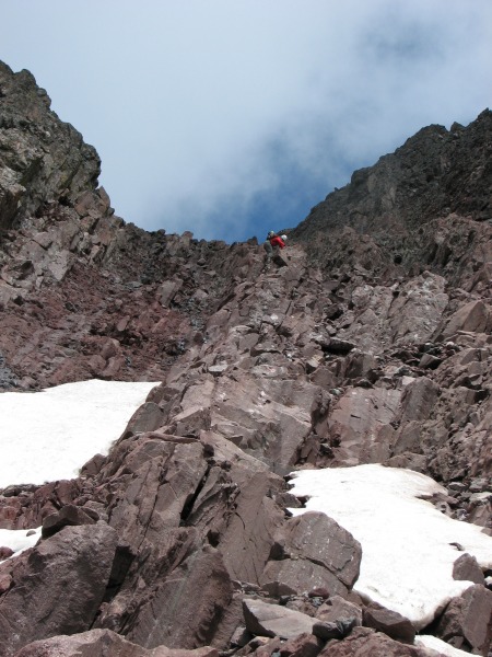 Once we topped out on the gully, we could see the series of ledges that would give us our first real taste of exposure for the day. The ledges are pretty well cairned, but again, not all of them lead to the best route, so don't follow them blindly. The series of ledges are is the first mental test of the route in my opinion. If they were 6 inches of the ground you probably wouldn't even think of looking for handholds, but with some spots of exposure, handholds suddenly seem like a good idea. Fortunately, they are wide and solid and good hand holds are abundant. Once on the summit, our excitement was some what tempered by the fact that we would have to down-climb the gully but the incredible views, complete lack of wind and the summit all to ourselves put those reservations on the back burner for a while. As it turns out, the only other two ppl we could see was roozers42 and Mel on the summit of the Needle. After 30 minutes we started down with some cloud build-up to the east and west, but nothing that looked too threatening. Once we hit the top of the gully we looked down with some dread of down-climbing the loose red gully. Once we got going, it wasn't too bad, there are sections of solid rock that we would get on for safer scrambling. The weather seemed to build pretty quick and what moments ago didn't seem threatening all of sudden looked to become an issue. We picked up the pace considerably knowing that we would, at bare minimum, need to get out of the gully before the weather turned and hopefully make it back over the pass. Once we got out of the gully, the clouds seemed to be less threatening and bad weather didn't seem eminent so I don't know if my mind was playing tricks on me. The slog back up Broken Hand Pass was tiring but the views at least make up for some of it.  We decided to leave the poles at camp thinking that they wouldn't be useful on the Peak and we sorely regretted that as they would have made coming down the pass a little less annoying. Once we were back at camp, we were able to enjoy our first accomplishments of the weekend. Saturday, 8/10 Hit the trail at 5:00 with some dread of doing Broken Hand Pass all over again. Having the Needle looking down at you most of the way does provide quite a bit of motivation to get up it though. 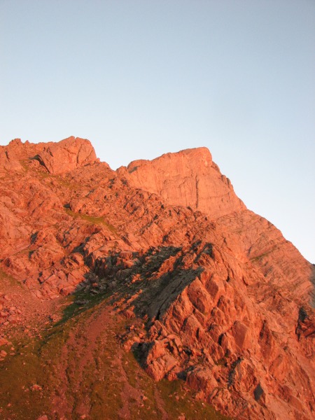 About half way up to the pass, Jen and Mel caught up with us. We swapped stories from the previous day's hike and they provided some invaluable advice on some of the trickier spots of the Needle's route. Talking with them and hearing about the hard parts that are coming actually helped suppress some of my nervousness and by the time I was done talking to them, I was so keyed up for the route. Today was the first day I felt I would truly see if hiking all the 14ers was a realistic goal for me. Mary was excited to see what a full on class 3 route was going to be like. At the top of the pass all four of us sat for a quick snack. After some last minute exchanges of encouragement we headed for the Needle while they headed for the Peak. The trail to the start of the east gully is easy to follow and even has a couple of quick spots to give you a taste of what's to come. We also were greeted by this family of big horn. 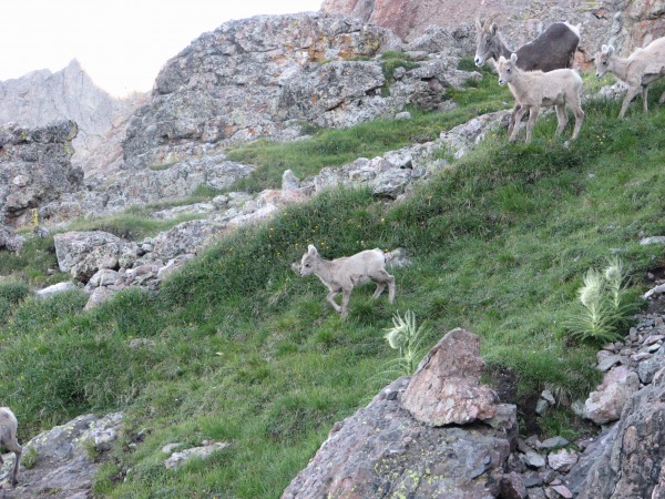 Once in the gully, we started up staying to the left (west) of the running water but after a brief bit of climbing we switched to the right side for easier terrain. It doesn't take long to realize why so many ppl talk about how much more enjoyable this route is compared to the Peak's red gully. The rock is fantastic and the scrambling is an absolute blast. Imagine a beginner's rock wall laid down on an angle. The route finding is fairly simple, you want to go up. There's a lot of variations on how to do it but if look around you should always be able to find a way to go upwards and remain at a class 3. The point where you have to traverse over to the west gully is fairly obvious in that the climbing looks to get more serious very quickly past it. There's a rock bridge that looks like it was created for the sole purpose of this route that will lead you to the traverse. Just keep an eye out for the rock formations shown in photo 13 of Bill route description. From the rock bridge you have to make what I though to be one of the trickier moves of the day to get on the ledge to cross the rib into the west gully. The holds are plentiful (check them first, because there are a few that seem loose) and you can get across in one or two moves. Once we dropped into the west gully and looked up to see what was left, we realized we still had a ways to go. Fortunately, the west gully is where this route really shines in my opinion. We had an absolute blast working our way up it. Mary led the way up and we generally stayed towards the middle. But as we gained confidence we were able to pick harder lines and get in what I believe to be some low level class 4 stuff. Working the east side of the gully for fun scrambling. 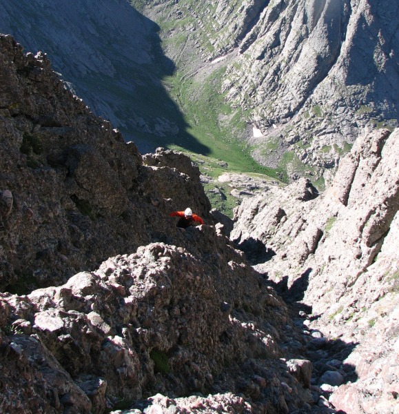 Once we topped out of the gully a trail lead us to the summit ridge and eventually the summit, which we had to ourselves for a few minutes anyway. A second day of near perfect weather allowed us to enjoy the summit for about 30 minutes before heading down. The down climb is pretty straight-forward and wasn't as hard as we were expecting however we did find ourselves off route three times. The first was right off the summit I wasn't paying enough attention and we left the summit ridge towards the top of the east gully instead of the west one. This was a mistake we quickly realized and was able to get back on track. The second was down-climbing past the exit point from the west gully. Despite Jen and Mel's advice to pay attention, as they did the same thing the day before, I went past it about 10 feet. The west gully gets very steap and loose just after the exit point so if you find yourself saying "I don't remember this part" then look around as you might be to low. Finally, about half way down the east gully I lead us around a rib on the far east side of the gully. I was following cairns but I believe they are for a different route. We eventually got cliffed out and knew that things weren't right. We were able to traverse west easy enough and then it became obvious where we should be. As a general rule of thumb, as your coming down the east side of the running water, keep it fairly close and you'll end up back at the point where you cross the water and end up on the trail that will exit out of the gully. From there the hike was uneventful, although we did have poles to make the decent off of BHP more tolerable. Sunday, 8/12 Won't write much about the trip up Humboldt as it's pretty straightforward. We wanted to summit in time for sunrise so we left at 315 and got there just in time, around 530. 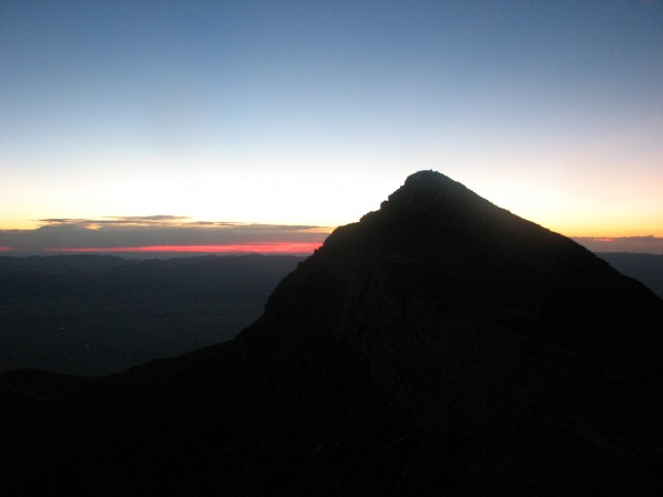 The trail up to about 13300 is very easy to follow with a headlamp. After that, it becomes a little harder to follow the broken bits of trail in the dark but it can be done if you take your time. If you comfortable crossing talus in the dark, a straight line up the ridge is probably faster than trying to route-find. The Exit and Afterthoughts During the hike back to the car, we were able to reflect on the Crestones and what it meant for future hikes. Neither of us would dare call ourselves mountain climbers but after these two summits I think we're more than mountain hikers. For those looking to transition away from the class 2 routes, I don't think either of these mountains would be a good first choice for a class 3 route. The looseness of the Peak and the length of the class 3 sections on the Needle would be a tough initiation I think. We did Wetterhorn the week before and felt like that was a great tune-up for the Crestones. These routes shouldn't be taken lightly and there isn't any real exit strategy if weather takes a turn for the worst. Having said that, anybody who's had a taste for class 3 routes like the Sawtooth or Longs and is ready to take it a step farther, these are special mountains to summit. Also, a helmet is a must on both these routes, especially on a day when it's busy. Thumbnails for uploaded photos (click to open slideshow):
|
| Comments or Questions | |||||||||||||||
|---|---|---|---|---|---|---|---|---|---|---|---|---|---|---|---|
|
Caution: The information contained in this report may not be accurate and should not be the only resource used in preparation for your climb. Failure to have the necessary experience, physical conditioning, supplies or equipment can result in injury or death. 14ers.com and the author(s) of this report provide no warranties, either express or implied, that the information provided is accurate or reliable. By using the information provided, you agree to indemnify and hold harmless 14ers.com and the report author(s) with respect to any claims and demands against them, including any attorney fees and expenses. Please read the 14ers.com Safety and Disclaimer pages for more information.
Please respect private property: 14ers.com supports the rights of private landowners to determine how and by whom their land will be used. In Colorado, it is your responsibility to determine if land is private and to obtain the appropriate permission before entering the property.


