Download Agreement, Release, and Acknowledgement of Risk:
You (the person requesting this file download) fully understand mountain climbing ("Activity") involves risks and dangers of serious bodily injury, including permanent disability, paralysis, and death ("Risks") and you fully accept and assume all such risks and all responsibility for losses, costs, and damages you incur as a result of your participation in this Activity.
You acknowledge that information in the file you have chosen to download may not be accurate and may contain errors. You agree to assume all risks when using this information and agree to release and discharge 14ers.com, 14ers Inc. and the author(s) of such information (collectively, the "Released Parties").
You hereby discharge the Released Parties from all damages, actions, claims and liabilities of any nature, specifically including, but not limited to, damages, actions, claims and liabilities arising from or related to the negligence of the Released Parties. You further agree to indemnify, hold harmless and defend 14ers.com, 14ers Inc. and each of the other Released Parties from and against any loss, damage, liability and expense, including costs and attorney fees, incurred by 14ers.com, 14ers Inc. or any of the other Released Parties as a result of you using information provided on the 14ers.com or 14ers Inc. websites.
You have read this agreement, fully understand its terms and intend it to be a complete and unconditional release of all liability to the greatest extent allowed by law and agree that if any portion of this agreement is held to be invalid the balance, notwithstanding, shall continue in full force and effect.
By clicking "OK" you agree to these terms. If you DO NOT agree, click "Cancel"...
Peak: Torreys Peak via Kelso Ridge (14,267'), Grays Peak (14,270')
Date: Sunday, July 29, 2007
Team: krz2fer (Chris), ajkagy (Adam), jessica (Jessica), Ryan (krz2fer's brother)
Route: Grays Peak Trailhead
Roundtrip: ~8 miles
This has been the best hike of the summer with some really cool people. "If you dislike exposure, avoid this route. There are several spots where the climbing is exposed and steep." This is true, too.
At the recent 14ers Denverites gathering Adam and I were discussing the possibilities of tackling the Kelso route up in the Grays and Torreys area. We had just met Jessica for the first time and she was interested in a solid Class 3 trek as well. From that point on, the rest was planning.
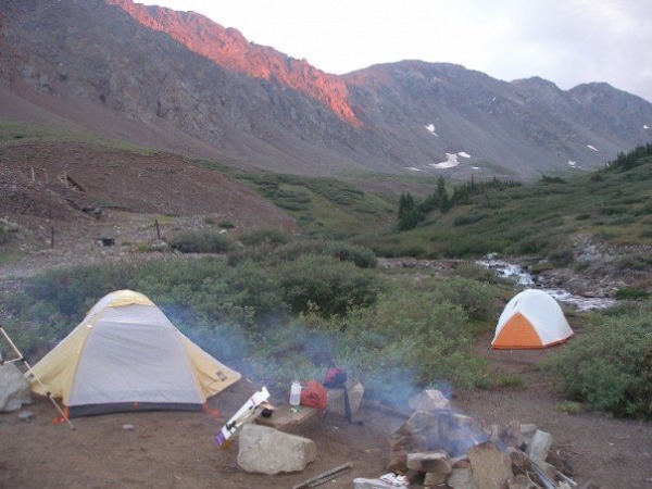
We decided to camp Saturday afternoon to get a feel for the area and acclimatize before the next morning's hike. Jessica met Ryan and me in Denver to head out around 3pm Saturday. Adam was to come later in the evening due to a family gathering. The trip was uneventful, but it did offer me a chance to break in my Outback Sport on the road. While a few spots were breath-holders for my vehicle, it became more of a challenge to pick the best routes up (and down) the road. I second, and third, and fourth recommendations that a 2WD Civic, etc. shouldn't be up there. In fact, I think we only saw two such vehicles the entire weekend. Note: there were only TWO cars in the lot when we arrived at 5:30pm. Plenty of camping options.
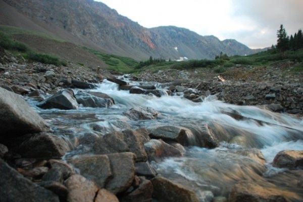
I saw a post about a sweet camping spot past the parking area, so we drove to the end of the road (it's chained off) and located an area right along the creek. We setup tents first as a rain shower was moving in. We ended up taking shelter for 15-30 minutes as the storm passed. Jessica loves making fires, and thus, was in charge of doing so. Ryan and I went looking for not-so-wet wood and finally after about 45 minutes we got one going. Smores and small chat ensued. We crashed around 9:30-10:00pm.
Our claimed area:
Jessica takes rad photos:
The 5:15am alarm greeted us with a shiver as temps had dropped in the 35-40 degree range, so we sat in the car to eat breakfast and get warmer. Adam didn't make it in the night before so we wondered if he'd slept in his car or just driven early in that morning. We drove down to the trailhead, found his car, and sure enough, he'd trekked ahead.
We started up at 6:00am, and the first 1.75 miles was very scenic and a pleasure to be on. I had my beer goggles on as I say; the initial .5-1 mile of my body saying "no" - but it wasn't too bad that morning. Certainly the camping helped.
Jessica snapping a photo of Chris and Ryan. I'm actually sleep walking here:
At the Kelso turn off Jessica decided against the climb and we parted ways. But wait! After a few additional encouraging words from a hiker who had done the route twice, she was quickly behind us. We took a little break to grab a snack at the base of the ridge. Adam was nowhere to be seen.
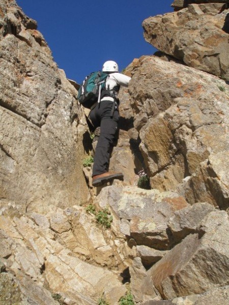
At 7:00 am, we strapped on helmets and off we went. Route finding became the theme for the next few hours, but in a very fun way. As Bill's description states, there are numerous paths to take, but I'll stick to the descriptions and specifics of the one we took. Could there be ways to avoid what I'm talking about? Probably. We all agreed that it could be as easy or as hard as you want to make it.
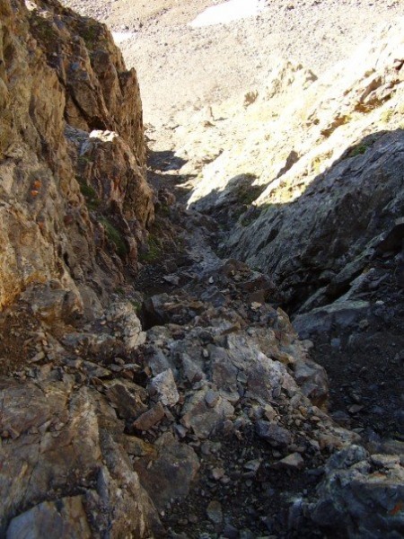
There is an initial up-climb within the first 1/4-1/2 mile of the ridge, which was a bit steep and tricky. This was high class 3 for sure. It was fun.
Ryan tackling this seciton:
After this section we saw a figure atop a rock outcropping ahead and it ended up being Adam, who had hiked in under darkness and had been perched there for almost an hour waiting. He'd been watching a couple other climbers head up as they chose routes.
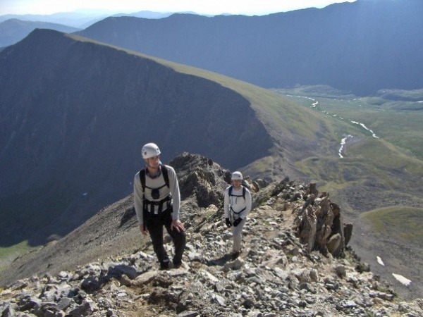
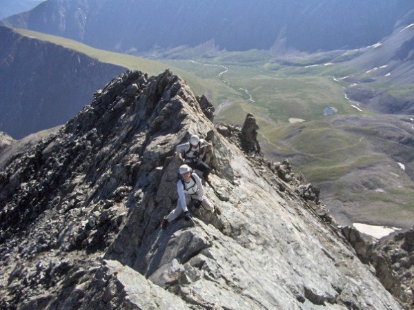
At this point we all met up and discussed the next route. We were happy NOT to be on the normal trail as it dawned somewhere between 350-897 hikers. Back to Kelso, it really all comes down to route finding. There are a few areas you cannot avoid being exposed, but we took it as a challenge.
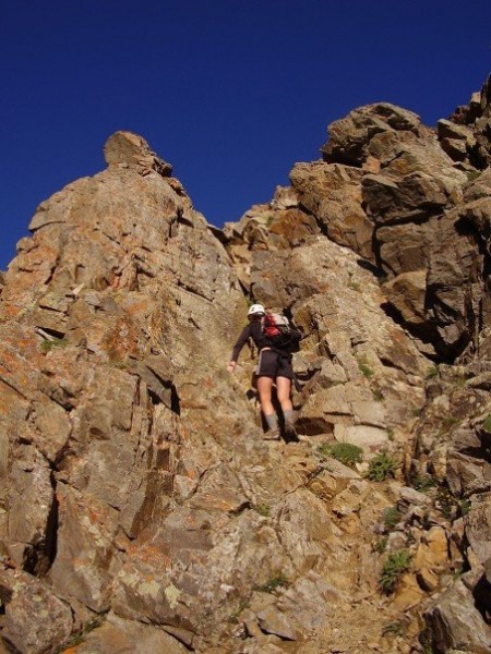
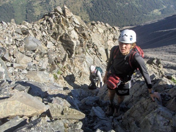
Jessica, looking up another steep portion:
Looking down a steep section:
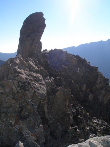
There are no shortages of interesting rock outcroppings along the route, which added to the uniqueness of this route. We took a break about halfway up and I snapped a photo of this cool feature:
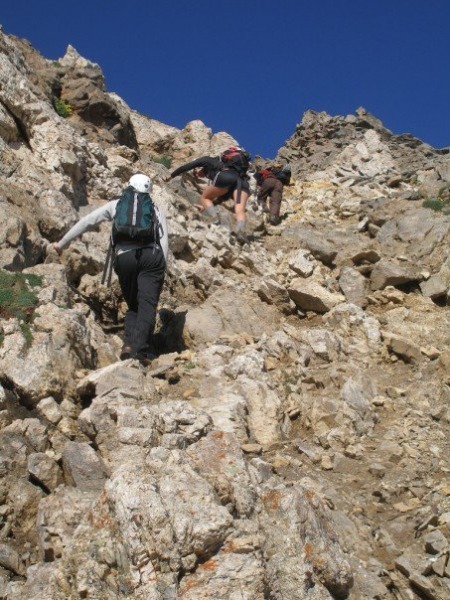
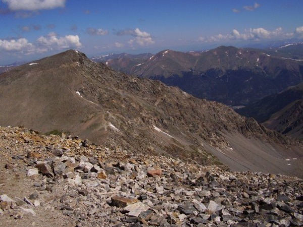
As the description says, things get steeper as you get higher. Here are a few photos for reference, terrain- and steepness-wise.
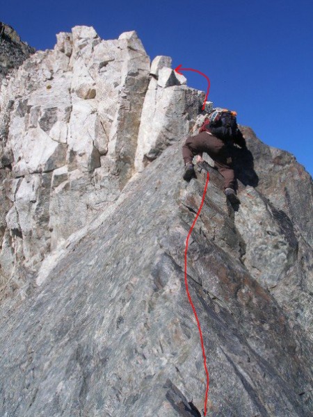
Just before the final pitch to the final tower and knife edge, a decision is to be made. You can either go left and kind of straight up, with a lot of exposure on the south side, or you can stay right, remain a bit low, and minimize the exposure to one shelf-like section. I don't have a photo as we were all concentrating on the best decision, but any hiker should know when approaching this area what I speak of. When in doubt, stay right.
As we crested that section, the knife edge became apparent. This thing is narly! Jessica decided to stay low, go right, and swing around to avoid this section. The three guys tested our man marbles (figuratively and literally) and went across. Exposure here is wild. I would not cross this in any other manner, except than with a pommel-horse-like straddle. There are very small foot holds and it is mostly a weight shifting / shuffling exercise.
Adam went first. Bill's image and note here are about dead on. Instead of going straight over the white tower, stay slightly right and stand on a small shelf like section to maneuver around it:
I went second with Ryan close behind:
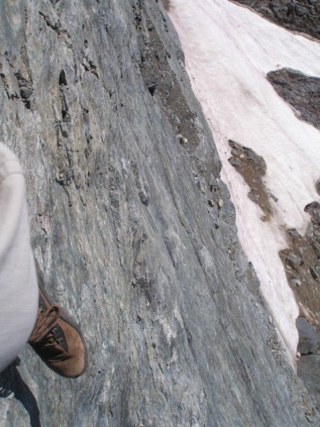
My foot, looking down the knife-edge. It was not straight down as this angle shows, but this gives you a feel for the fact that nothing is below you on either side:
The scramble up to Torreys was pretty quick and the summit was there before we knew it. We summited at 9:30am, totally stoked. What a great run to the top. We all loved it. We took a break for 15 minutes to get a snack, and then headed over to Grays. The trail suddenly seemed so lame compared to the ridge. Boring even. We summited Grays at 10:30am, along with a quarter million other people. I've never seen anything like it, and I'm not a fan of the crowds.
A final look at the ridge coming down Grays:
On the way down we passed countless people. 11:00am, 12:00pm, people still coming up, dressed inappropriately, talking on cell phones, carrying only a 12oz Gatorade in sneakers. These things will never cease to amaze. We arrived back at the parking lot at around 12:45pm. By the way, what a disgusting privy. I didn't go in, but I smelled it from 30 feet away. Ryan had the pleasure of checking it out first hand, and it's a real doozy!
Final thoughts...
(1) It beats the heck out of doing switchbacks for a few hours and it's a better feeling of accomplishment as well.
(2) If you think you can do it, you can. If you kinda-sorta don't think you can do it, go with someone experienced that can encourage you.
(3) Helmets are nice for safety. Too many times rocks, pebbles, fist-sized pieces came tumbling down. It was good to have.
We all highly recommend the route to anyone looking to do something a bit different and to energize a typical hike with something atypical and very rewarding. Now, if only there was an alternate route back to Denver via I-70 on a Sunday...
Thumbnails for uploaded photos (click to open slideshow):
Nice pictures. I was up that way a couple of weekends ago and saw the same type of people heading up dressed for a BBQ and starting way too late in the day. People will never fail to surprise me. I hear you about the traffic. We got stuck on I-70 on the way back down for no apparent reason. It took us two additional hours to get back to FC.
Hey thanks for the report and the sweet pictures! I'm planning on doing this route tomorrow morning for my birthday and I'm way excited. "If you think you can do it, you can." is really great to know! I'll post some pictures of my own when I get back.
I saw a guy hiking up two weeks ago at around 1200 smoking a cigarette :shock:
Caution: The information contained in this report may not be accurate and should not be the only resource used in preparation for your climb. Failure to have the necessary experience, physical conditioning, supplies or equipment can result in injury or death. 14ers.com and the author(s) of this report provide no warranties, either express or implied, that the information provided is accurate or reliable. By using the information provided, you agree to indemnify and hold harmless 14ers.com and the report author(s) with respect to any claims and demands against them, including any attorney fees and expenses. Please read the 14ers.com Safety and Disclaimer pages for more information.
Please respect private property: 14ers.com supports the rights of private landowners to determine how and by whom their land will be used. In Colorado, it is your responsibility to determine if land is private and to obtain the appropriate permission before entering the property.