| Report Type | Full |
| Peak(s) |
Mt. Eolus - 14,087 feet Sunlight Peak - 14,061 feet Windom Peak - 14,089 feet |
| Date Posted | 07/29/2007 |
| Date Climbed | 07/29/2007 |
| Author | Ecocrazy |
| From Vallecito Reservoir (via Columbine Pass) to Purgatory |
|---|
|
A bunch of firsts -- my first trip report, first class 4 climb (though some have called it 3+), first climb without the handy pictorial step-by-step guide of 14ers.com, and first solo backcountry outing of this magnitude. I opted not to take the standard train-to-Needleton route to Chicago Basin in part because I had the time and was looking for a longer adventure, but also because that train sucks. I went to school in Durango, and while I recognize it‘s the heart of the tourist economy there, and especially in Silverton, do a google image search for it, and you‘ll see that the primary attraction is the coal smoke it puts out. The smoke coats the buildings throughout the towns, the noise pollution and city-flow interruption are intense during the summer, and frankly, riding it is boring - the tourists are always happy and waving and taking pictures on the way out of town, and then look sea-sick upon returning. But I digress. . . I left Durango Monday morning around 9, took a wrong turn at Vallecito Reservoir and ended up at the Pine River TH. Thankfully there was a family from Texas there to point out my mistake. Started hiking at 11, lots of people for the first 500m, and about two after that in as many days. The Vallecito Creek Trail is rather flat, and plenty beautiful. 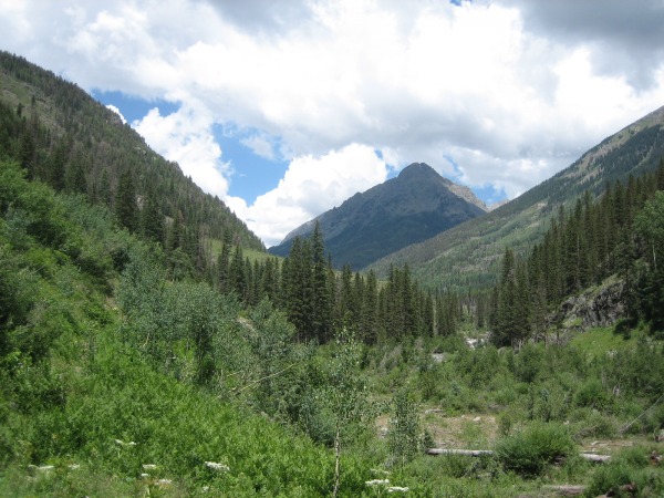 Around 7 miles in, there was an avalanche along the trail, and so suddenly I found myself in a class 2 scramble over fallen trees. 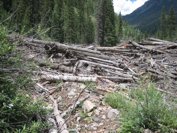 The avalanche also took out a bridge, so you have to ford the creek. Ahead on Johnson‘s Creek, there are plenty more fordings, so forget about keeping your feet dry. As you‘re walking along the left side of the creek, a small clearing containing two cairns points to a barely disernable break in the brush to a crossing where the USFS has kindly put up a rope. If you walk past it, the trail soon fades. This is looking back on the crossing. 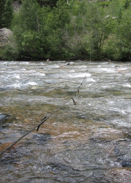 Around 2pm, I was just shy of Johnson‘s Creek when the thunderstorms rolled in, and I must‘ve not had my backcountry mind on yet, because though I got my tent up before it really started raining, I managed to get me and a lot of my gear thoroughly soaked. Started hiking the next morning around 8am (clearly, still not in backcountry mode). Johnson‘s Creek is much more ascending than Vallecito Creek, and it took about four hours for me to reach Vallecito Basin, at which point, again the storms were rolling in. Not wanting to exit the wooded cover for the slog over Columbine Pass in a storm, I set up camp resigned to the fact that I wouldn‘t be reaching Chicago Basin until my third day out and fell asleep under my bag, only to be woken a couple hours later by intense sun hitting the tent. Poked my head out of my tent and skies were blue above and that mopey sort of exhausted-storm-looking overcast on the horizons. So I quickly packed up and headed for Columbine Pass. On my way up I noticed a couple hikers, a father and son, behind me - the first people I‘d seen in over 24 hours. The ascent up Columbine is a slog, especially carrying overnight gear and four days worth of food. Columbine Lake was surrounded with beautiful wildflowers. This is from the top, looking back at the lake, Vallecito Basin and - correct me if I‘m wrong here - Florida Mtn and Mt Valois. 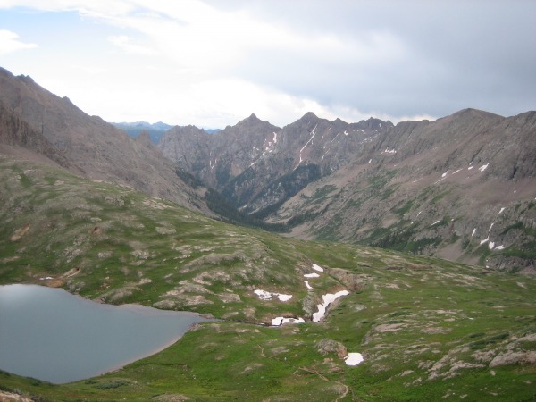 From the top the decent around Jupiter Mtn‘s SW side is rapid and Chicago Basin comes quickly. After the solitude of those first two days, I was half expecting boom boxes and kegs in Chicago Basin -- instead, the first thing I saw was the CFI base camp surrounded by a dozen or so goats. In the upper-basin, there were only a handful of tents, I suppose because, as my neighbor informed me, there had been a mudslide on the train tracks, and so Cascade was the closest the trains could get, adding another four miles or so to the hike in. Glad to have been there with fewer people than perhaps other mid-summer times. Now for the fourteeners. I started hiking at 5:30am and reached Twin Lakes at 6:15. Coming to Twin Lakes - after the steep trail up there, alone in the early-dawn light, with the glass-smooth water and surreal spires behind - I swear my first thought was that I had entered a new land in the world of "Zelda". Laugh all you want, that really was my first thought. The Twin Lakes Basin is has to be among the most enchantingly beautiful place I‘ve been. 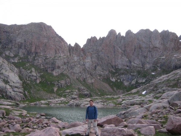 Since I didn‘t have a 14ers.com guide to Eolus, I figured I‘d start there since the time-variance for that climb, and the potential for getting off-route, was highest. From Twin Lakes, the trail to Eolus is visible in the distance to the left (W), but unless I just missed it, isn‘t continuous through that basin. There are cairns though, and it‘s not at all hard to find. The route up is quite obvious until the final few hundred vertical feet. It seemed to me more natural to start with North Eolus. The final section was relatively exposed, but nothing difficult. That is, while I never felt in jeopardy of missing a move, it never left my mind how bad it would be if I did. I summited around 8 and could barely take my eyes off the "catwalk in the sky". 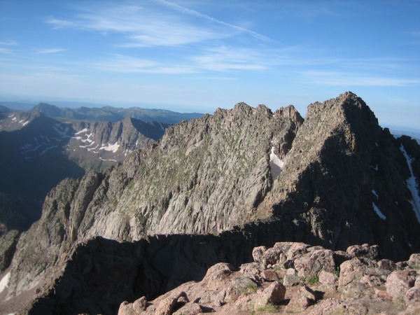 The decent down to the saddle was obvious, but on the ascent I stayed too tight to the ridge, and as a result made the route much trickier than it needed be. The proper route veers left from the ridge significantly at times. It took over an hour for me to reach the summit from North Eolus. Spent a while up there, topo in hand, identifying everything in sight. On the decent, stayed with the cairns near the top and was surprised by how much more strait-forward the route was than what I had done. Met lots of neat people on the way down - a Boy Scout group from Arizona, an Air Force couple from CO Springs and some older folks also from the springs, one of whom was getting close to finishing the Colorado 14ers. Further on the way down, just above the top of the grass, I realized I had descended way too far left (E), in the wrong gully and had to scoot down over some big, steep, wet rock slabs to get back to the route. Quite uncomfortable but without event. A couple pictures from the trail between Twin Lakes and Chicago Basin: 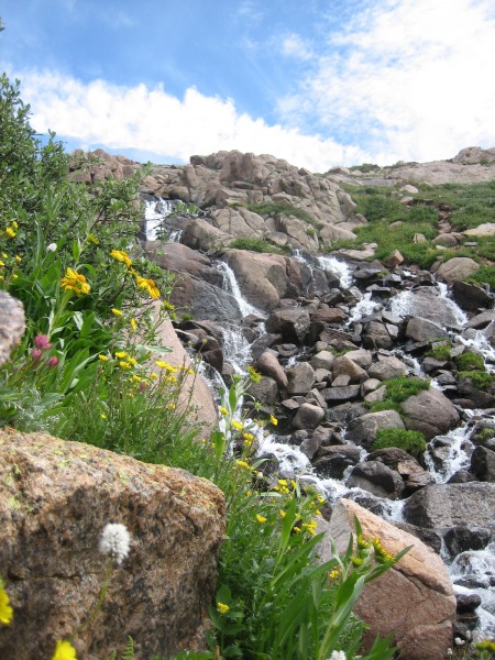 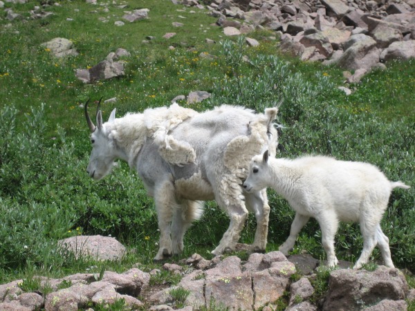 Got back to camp around noon, crawled into the tent for the coming storm and much to my surprise slept for four hours. Woke up to eat and piss and went back to sleep until 4:30 Thursday morning. When day began to break on Thursday, I noticed something I hadn‘t seen so far on this trip -- cloudy skies at dawn. I wasn‘t sure what this would mean for conditions later in the morning, but I wasn‘t too excited to see it. Again was hiking at 5:30 and at Twin Lakes at 6:15. Turned up to the right (SE) of the lakes and followed the good trail up the headwall into the basin under Sunlight and Windom. Turned left (NE) across a little snow to reach the talus slog up Sunlight‘s south face. No trouble here, but I should‘ve been paying more attention to the route, as I ended up going a little too high toward the saddle before turning left. After I realized that though, cairns were easy to find and the route up to the class 3 climbing was easy to find. I thought the upper section of this climb was a lot of fun, and immensely beautiful.  Reached the USGS marker, 20 vertical feet shy of the summit, without incident. I had been telling myself that if I didn‘t feel comfortable with the last moves, I just wouldn‘t do them. But once I was up there, I didn‘t really have a choice. My backpack came off and I scrambled up to the third block from the summit without hesitation. From there, I was able to leaning up against the second block and just reach a real solid hand hold and pull myself up. My ascent is in green, the hand hold is near the blue dot, and my decent in red. 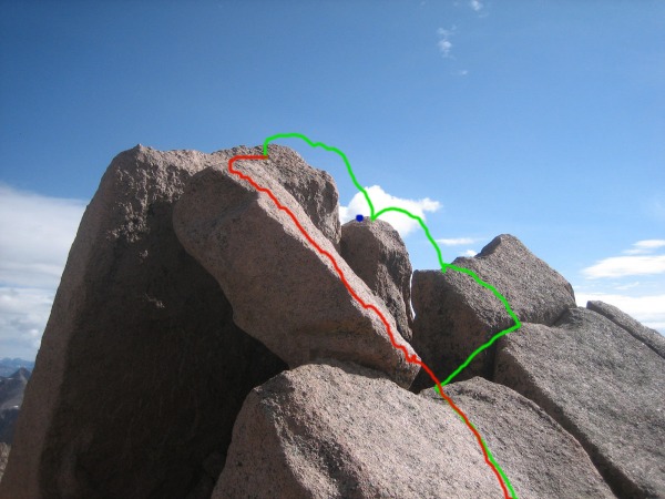 This all went so smoothly that I didn‘t even think about how I was going to get down. Once I was up on the summit though, I kind of wished I had. Here‘s me, scared out of my mind, straddling the summit block. 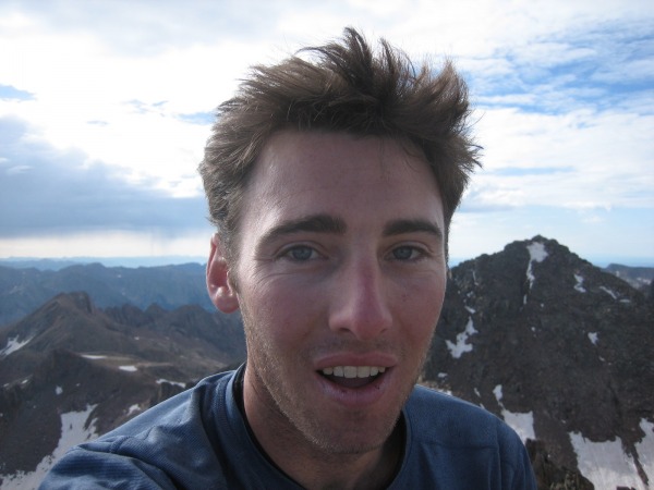 In a nicely ironic twist, the first sunlight of the day hit me while I was sitting on the summit of Sunlight Peak. On the way down, I sat, looking at the jump from the second to third block for a good fifteen minutes, totally unable to move. It felt like being on the high-dive as a kid or on the ropes course at summer camp, except that in those situations, someone was certifying that it was safe, and I was able to push the fear out of my mind with the rational knowledge that I wouldn‘t get hurt. Here though, there was no such logic to fall back on. My hands shaking and pulse at 100 bpm, I sat up there for a good 15 minutes, knowing the jump is one that I‘d make without incident 99.?% of the time, but totally paralyzed. Eventually I looked back at the other block supporting the summit rock and realized that I could scoot down it on all five (my ass being the fifth), and while it might be less likely to go without incident, the exposure was so much less that it seemed the way to go. I was able to scoot under control all the way down, and was pretty thrilled to be there. Had a snack and signed the register, and now after 9:15, with a storm brewing to the east, I set my sights on Windom. The storm clouds were looking severe, the rain was already falling a valley over to the eat, but the wind was blowing to the east and skies were blue above. So I hustled down Sunlight‘s south face and across the snow field in the valley between the two (there‘s a pretty decent patch of snow to cross now unless you choose to descend further to meet up lower with the original Windom route). The climb up Windom‘s west ridge is strait forward class 2 scramble, and while the Boy Scouts I had met yesterday I decided to turn back because of the storm, I, and a family a few hundred yards below, felt there was time, and so climbed pretty furiously to the summit, and was off it by 10:15. As it turned out the storm didn‘t reach Chicago Basin until about one. So in this case at least, cloudy sky at sunrise didn‘t mean earlier storms. Here‘s a view of Twin Lakes and the Eoluses from Windom‘s summit: 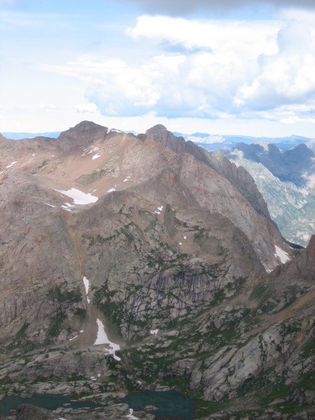 After once again napping through the afternoon thunderstorm, I awoke at 2:45 thinking of the red curry at Sizzling Siam in Durango and wondering if I could do the 14 miles out to Purgatory before sunset. I couldn‘t. Around six I was near the Animas/Purgatory Trail Junction when dark clouds again threatened, so I set up camp there. The next morning I woke up and quickly crossed the Animas River bridge. After this crossing, the trail gets funky - you turn left (S) on the trail out of the bridge in order to get into the canyon to your right (NW) that will take you out to Purgatory/DMR. The trail cuts back through a meadow and up a decent length of switchback before it‘s clear that you are entering the Purgatory Trail canyon. After those switchbacks, the hiking is mild until the very final section, the last mile or so through aspens, where you gain something like 1000 or 1500 vertical feet and then suddenly emerge on Highway 550 right at Purgatory. Put my thumb out and it took about three minutes to find a ride back to Durango. In the end, it was an awesome trip. I‘m really grateful to have been able to spend so much time in such a gorgeous wilderness area and to have climbed such magnificent mountains. I‘d definitely recomend this approach over the train approach to anyone who has the time. My appologies for the length of this post - I‘ll have to work on being briefer in the future. Thumbnails for uploaded photos (click to open slideshow):
|
| Comments or Questions | ||||||||||||
|---|---|---|---|---|---|---|---|---|---|---|---|---|
|
Caution: The information contained in this report may not be accurate and should not be the only resource used in preparation for your climb. Failure to have the necessary experience, physical conditioning, supplies or equipment can result in injury or death. 14ers.com and the author(s) of this report provide no warranties, either express or implied, that the information provided is accurate or reliable. By using the information provided, you agree to indemnify and hold harmless 14ers.com and the report author(s) with respect to any claims and demands against them, including any attorney fees and expenses. Please read the 14ers.com Safety and Disclaimer pages for more information.
Please respect private property: 14ers.com supports the rights of private landowners to determine how and by whom their land will be used. In Colorado, it is your responsibility to determine if land is private and to obtain the appropriate permission before entering the property.


