Download Agreement, Release, and Acknowledgement of Risk:
You (the person requesting this file download) fully understand mountain climbing ("Activity") involves risks and dangers of serious bodily injury, including permanent disability, paralysis, and death ("Risks") and you fully accept and assume all such risks and all responsibility for losses, costs, and damages you incur as a result of your participation in this Activity.
You acknowledge that information in the file you have chosen to download may not be accurate and may contain errors. You agree to assume all risks when using this information and agree to release and discharge 14ers.com, 14ers Inc. and the author(s) of such information (collectively, the "Released Parties").
You hereby discharge the Released Parties from all damages, actions, claims and liabilities of any nature, specifically including, but not limited to, damages, actions, claims and liabilities arising from or related to the negligence of the Released Parties. You further agree to indemnify, hold harmless and defend 14ers.com, 14ers Inc. and each of the other Released Parties from and against any loss, damage, liability and expense, including costs and attorney fees, incurred by 14ers.com, 14ers Inc. or any of the other Released Parties as a result of you using information provided on the 14ers.com or 14ers Inc. websites.
You have read this agreement, fully understand its terms and intend it to be a complete and unconditional release of all liability to the greatest extent allowed by law and agree that if any portion of this agreement is held to be invalid the balance, notwithstanding, shall continue in full force and effect.
By clicking "OK" you agree to these terms. If you DO NOT agree, click "Cancel"...
Route:
-Start at Montezuma road
-From Peru Creek Road up into Chihuahua Gulch
-From Chihuahua Gulch up into Ruby Gulch to Grays Summit via South slopes
-Ski Descent of South Slopes
Stats:
-Elevation Climbed and Skied: 4,400'
-Mileage RT: 13 miles
The Failed Attempt:
Killingcokes and I attempted this route the day of the Stanley avalanche path slide on Berthoud Pass. We had some issues with getting away from trailhead at a reasonable time due to crazy ski traffic. Oh ya, and my dumb ass forgot my beacon so we had to drive back into Silverthorne to rent one. We quickly motored up the 3 miles to Chihuahua Gultch TH and by the time we got the sleds 0.25 miles up Chihuahua and tried to dig them out a few times, it was 10:30am. The weather was holding, so we continued on. When we reached the old mine shack below Grays South slopes at 12,300', the temp was -10 and the wind was blowing snow around with 45-50 mph gusts. Wind chill was, well, chilling. Up high there were probably 75-80mph gusts. As I stepped into the broken down cabin to seek shelter a 5 inch deep softslab about 5 square feet in size fractured with tons of energy and slid under the floorboards. Clearly the summit was out of question.
The Return:
We immediately planned a new date to get this summit skied, which was the 27th of January. Dobish decided to come along as well, a strong tele skier from Golden. It was his birthday and I just completed a chinese proverb for luck, so we were ensured a top notch outing. We met at TREX much earlier this time at 4:00am to beat the crazy Denver ski mob up the hill and were ready to roll at the TH at 6:15am. Unfortunately, Dobish lent his gear to someone who left the bindings adjusted to his boot size, so while he tried to figure that out, the sled overheated from idleing for too long and spit all its antifreeze onto the ground. No sled ment the trip just got 6 more miles and 1000' of vert added onto it.
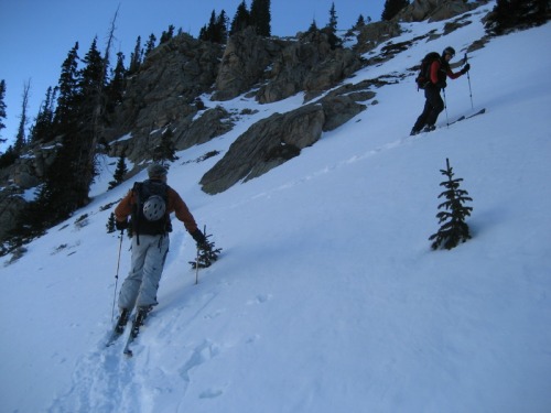
We skinned up the Peru Creek Road and turned up Chihuahua Gulch just as the sun was really lighting things up. To get into Ruby Gulch, we ascended some steep terrain right below treeline to avoid the alternative of very dense woods choked with deadfall.
Skinning up into the basin below Grays South slopes
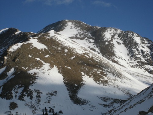
We got a really good view of the route from here.
Grays South slopes from treeline
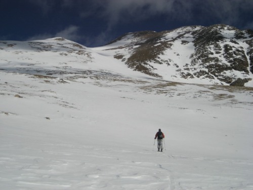
The skin up the South slopes was good practice in steep ascent skills with the skis.
Fritz skinning up Grays South slopes Jeremy skinning up Grays South slopes
Fritz's skins are old and dont stick or grab so well anymore so he ended up having to boot up the ridgeline, which was probably pretty miserable with the gusts of 30-40mph and some unconsolidated snow. We all ended up booting up the final 300' of ridgeline. I had some time alone to relax and enjoy the winter on a 14er for at least 30 mins until Dobish and Fritz arrived. The hard part was over, now for the payoff.
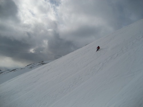
Ski Descent of South Slopes:
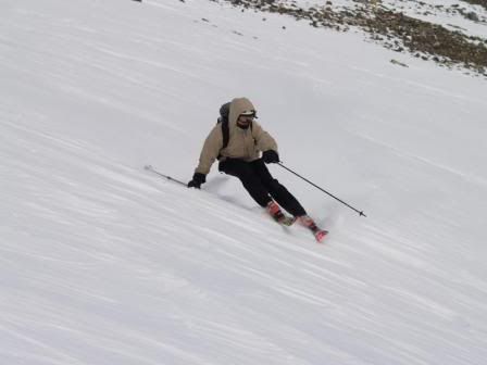
The snow conditions for skiing were as good as you could hope for after a week of high pressure, and our route was solid as a rock stabilty wise. There were tons of turns to be had down the styrophome. There was a break in the snow coverage about 50 feet below the summit, but it was short enough to sidestep so I was able to keep my skies on from the summit to the truck back at Montezuma Road.
Me taking the first turn off the summit of Grays
Dobish making it look easy
Fritz getting it done on a spectacular winter day
Me enjoying gravity
Dobish making it look easy again
There were many turns down the 4700 vert
Ski Route
The ski through the trees was either too dense to let em fly, or money recycle pow with perfect tree spacing. This day was a good day.
Another TR on this trip with more pics can be found here:
http://www.tetongravity.com/forums/showthread.php?t=75146
Thumbnails for uploaded photos (click to open slideshow):
That pic of your buddy Fritz with the sun trying to pop through the clouds is somethin else, its inspiring me to take my gear out of the closet for one last adventure this late winter season.
Caution: The information contained in this report may not be accurate and should not be the only resource used in preparation for your climb. Failure to have the necessary experience, physical conditioning, supplies or equipment can result in injury or death. 14ers.com and the author(s) of this report provide no warranties, either express or implied, that the information provided is accurate or reliable. By using the information provided, you agree to indemnify and hold harmless 14ers.com and the report author(s) with respect to any claims and demands against them, including any attorney fees and expenses. Please read the 14ers.com Safety and Disclaimer pages for more information.
Please respect private property: 14ers.com supports the rights of private landowners to determine how and by whom their land will be used. In Colorado, it is your responsibility to determine if land is private and to obtain the appropriate permission before entering the property.


")
")
")
")
")
")
")
")
")
")


