| Report Type | Full |
| Peak(s) |
Humboldt Peak - 14,068 feet |
| Date Posted | 08/07/2006 |
| Date Climbed | 08/05/2006 |
| Author | fleetmack |
| Humboldt Peak - South Colony Lakes |
|---|
|
Summit Elevation - 14,064 Elevation Gain: 4000ft (estimate, parked 2 miles from upper TH, the XTerra couldn't make it the whole way up) Trip Distance: 11.5 miles (estimate) Total Round-Trip Climb Time (including 15 minutes on summit): 7:15 (could have cut off 2 hours if we had started at the TH) 4WD Required: hell yes, hell yes Exhaustion Factor (on scale of 1-10): 5 Scenery Factor (on scale of 1-10): 6 (would have rated it higher, but clouds were everywhere) I picked Miriah up at 2:15am and we were on I25 S by about 2:30. Take I25S to Pueblo, where you get on HWY 96 ... go west for about 50 miles to Westcliff. In Westcliff, go South on HWY 69 for about 5 miles then you turn on Colfax lane. No hookers on this Colfax, only Cows. Go for about 5 miles on this road (any car can make it, although most of it is a dirt road). Here you come to the standard car and 2WD parking. A high clearance truck can make it from here for a couple miles, but after 1 or 2 miles, 4WD and high clearance are a necessity. The 4WD road is about 5 miles long. We picked up a hiker about a mile into the drive and made it 3.5-4.0 miles up in the XTerra. Total drive to our parking spot from Denver: 3:30. We started hiking the remainder of the road just before 6am. We were surprised to see a few standard pickup trucks at the trailhead at the top, I'd imagine they left some parts of their car behind or have severe damage underneath. I have pictures posted here of what this road looks like, pretty rough one: http://www.14ers.com/bb/viewtopic.php?t=3041&start=0 Anyways, finally at the upper TH at 7:00am. After a stroll through the campsites (and easy hiking area)  and while enjoying slightly-cloud-covered views of the Crestones, we crossed a stream, passed lower South Colony Lake, and started climbing up. The trail switches back most of the way up: 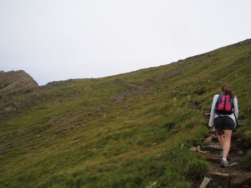 past Upper South Colony Lake, to a saddle that is a straigh-shot to the summit. After an hour or so on rock-scrambling  ...and trail-losing (the sun was shining right in our face, hard to find cairns!) we reached the false summit, and then had a pretty easy stroll along the ledge  to the real summit, arrived around 10:00am. There were 5 or so people on the summit trying to get pictures of the Crestones when the clouds would allow, but after 10 minutes or so, a Cliff Bar, and a summit photo, we decided to get down in case the clouds got threatening, leaving the summit at 10:15. The clouds were rolling in and we got sprinkled on a bit, but nothing too serious. Watch out for Marmot shit, it's everywhere! It took us about 2 hours to get back to the TH and another hour or so to get back to the car. You know right before you go to sleep, and you're counting sheep, you picture them kind of arc-jumping across in your mind ... about 1/2 mile from the car, this friendly girl: 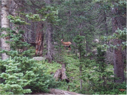 out of nowhere jumps across the entire road about 10 feet in front of us, silent as can be. This was very cool. We got back to the car around 1:15, down the 4WD road, to Westcliff (where we ate at Subway), and back to Denver around 5:30. Great trip, 4th summit of the summer, looking forward to Holy Cross next week, Shavano & Tabeguache the week after, and finally, Crestone Peak (and the Needle?) over Labor Day. Giddy up! Check out all of my pictures of this climb here: http://www.fleetmack.com/gallery2/main.php?g2_view=core.ShowItem&g2_itemId=2145 Thumbnails for uploaded photos (click to open slideshow): ")
")
")
")
")
|
| Comments or Questions |
|---|
|
|
Caution: The information contained in this report may not be accurate and should not be the only resource used in preparation for your climb. Failure to have the necessary experience, physical conditioning, supplies or equipment can result in injury or death. 14ers.com and the author(s) of this report provide no warranties, either express or implied, that the information provided is accurate or reliable. By using the information provided, you agree to indemnify and hold harmless 14ers.com and the report author(s) with respect to any claims and demands against them, including any attorney fees and expenses. Please read the 14ers.com Safety and Disclaimer pages for more information.
Please respect private property: 14ers.com supports the rights of private landowners to determine how and by whom their land will be used. In Colorado, it is your responsibility to determine if land is private and to obtain the appropriate permission before entering the property.

