| Report Type | Full |
| Peak(s) |
Mt. Lindsey - 14,055 feet |
| Date Posted | 07/31/2006 |
| Modified | 08/01/2006 |
| Date Climbed | 07/30/2006 |
| Author | aubrey |
| Lindsey - standard North Face route |
|---|
|
With only a few hours of sleep under our belts, my wife and I checked out of our hotel on the south side of Pueblo at 4 a.m. on Sunday, July 30, and set off down some lonely roads toward Lindsey's trailhead. The dark, quiet back roads were filled with suicidal animals. You name it, mice, rabbits, deer - they all seemed to have a death wish. Thanks to my quick reactions and quality brakes, their wishes weren't granted. Far off the beaten path and well into the boonies, we continued down some pretty desolate roads. The morning sun slowly exposed a tremendously beautiful valley. Lusciously green meadows, cascading creeks, flickering aspens and craggy peaks set the scene. The 4WD road to the trailhead was pretty easy. Most high-clearance SUVs and trucks should be able to make it to the end without too much trouble. And with some care (and going a little slower), some lesser vehicles could probably make it to the end as well. There were mostly trucks and SUVs in the parking lot, though I remember seeing one Subaru Forester. From the parking lot, we started up the trail at 6 a.m. The first part of the trail (for a mile or so) was fairly level and easy to walk on. Having climbed Mt. Massive the day before, this was a great warm-up, and it felt good to slowly "ease into" the climb. Walking on the slippery logs across the creek helped to wake me up. Or was that surge of energy from licking the mushrooms?  Shortly after we left the flat section, the trail climbed steeply into the forest. This steep ascent continued much longer than I expected. Oh, and there were some muddy sections to deal with. Needless to say, the trekking poles came in handy. At one point, after pushing through the last patch of trees, it seemed like we just "popped up" into the basin. And that's when we had a 360-degree view of the area. It seemed like the most peaceful place on Earth. High peaks cradled and guarded this serene piece of land. The air was still and it was impossibly silent. My wife commented, "...we're surrounded by greatness." I was thinking the exact same thing. After climbing up out of the basin, we made it to the ridge between the Iron Nipple and Lindsey at 8:30 a.m. From there, we traversed along the easy trail over to the base of the gully. As we started up the lower gully, we laughed at how much of a cakewalk it was compared to Massive's west slope that we went toe to toe with the day before (if you haven't already, check out my trip report on that badboy). This isn't to say Lindsey's gully didn't require attention; it was just much easier than the hell we had to deal with the day before. 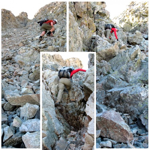 As we ascended, we found hand holds and foot holds relatively easy to find. Most of the rock was pretty stable, though some rocks were only partially embedded, and they would shift or crumble when you latched on. It was a good idea to test them first. While there weren't any other climbers directly above us as we climbed, I'm glad we brought our helmets. It was almost impossible to keep yourself from occasionally setting rocks free to the force of gravity. And even the little rocks would tumble down pretty fast, bouncing their way to the lower depths of the gully. I kept looking back down to make sure nobody was coming up behind us before making big moves over loose rock. The lower gully was short, ending at a narrow notch, which was fairly easy to climb up. The route then crested, went down a few feet, and then back up a pair of rock chutes. I think we went up the left one on our way up and down the right one on our way down (climber's left both times). At any rate, there were multiple options to take. From there, a trail appeared, which led to the ridge. The ridge was easy to follow to the summit. Made it to the summit at about 9:35, hung out for a bit and met a few friendly climbers. 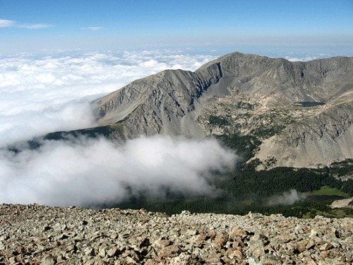 We started our climb back down the mountain under beautiful skies and seas of fog in the valleys below. Before making it back to the ridge, we ran into at least a few small groups of climbers on their way up. Overall, I think we only came across about 20 people all day. 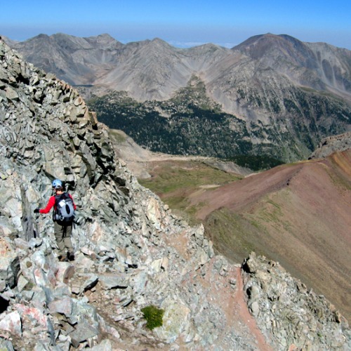 As we descended, I was reminded of how beautiful the Sangres are, especially with the jagged Crestones in the distance (posted a pic I took of them in the "more photos" section). Rather tired, we made it back to the trailhead at 12:15. 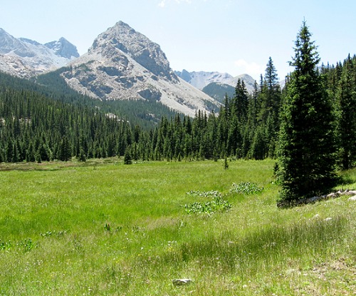 Thumbnails for uploaded photos (click to open slideshow): ")
")
")
")
")
|
| Comments or Questions |
|---|
|
|
Caution: The information contained in this report may not be accurate and should not be the only resource used in preparation for your climb. Failure to have the necessary experience, physical conditioning, supplies or equipment can result in injury or death. 14ers.com and the author(s) of this report provide no warranties, either express or implied, that the information provided is accurate or reliable. By using the information provided, you agree to indemnify and hold harmless 14ers.com and the report author(s) with respect to any claims and demands against them, including any attorney fees and expenses. Please read the 14ers.com Safety and Disclaimer pages for more information.
Please respect private property: 14ers.com supports the rights of private landowners to determine how and by whom their land will be used. In Colorado, it is your responsibility to determine if land is private and to obtain the appropriate permission before entering the property.

