Download Agreement, Release, and Acknowledgement of Risk:
You (the person requesting this file download) fully understand mountain climbing ("Activity") involves risks and dangers of serious bodily injury, including permanent disability, paralysis, and death ("Risks") and you fully accept and assume all such risks and all responsibility for losses, costs, and damages you incur as a result of your participation in this Activity.
You acknowledge that information in the file you have chosen to download may not be accurate and may contain errors. You agree to assume all risks when using this information and agree to release and discharge 14ers.com, 14ers Inc. and the author(s) of such information (collectively, the "Released Parties").
You hereby discharge the Released Parties from all damages, actions, claims and liabilities of any nature, specifically including, but not limited to, damages, actions, claims and liabilities arising from or related to the negligence of the Released Parties. You further agree to indemnify, hold harmless and defend 14ers.com, 14ers Inc. and each of the other Released Parties from and against any loss, damage, liability and expense, including costs and attorney fees, incurred by 14ers.com, 14ers Inc. or any of the other Released Parties as a result of you using information provided on the 14ers.com or 14ers Inc. websites.
You have read this agreement, fully understand its terms and intend it to be a complete and unconditional release of all liability to the greatest extent allowed by law and agree that if any portion of this agreement is held to be invalid the balance, notwithstanding, shall continue in full force and effect.
By clicking "OK" you agree to these terms. If you DO NOT agree, click "Cancel"...
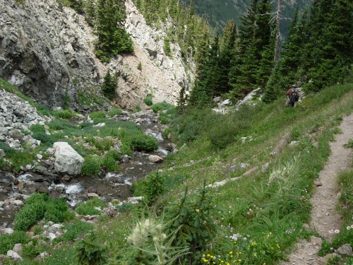
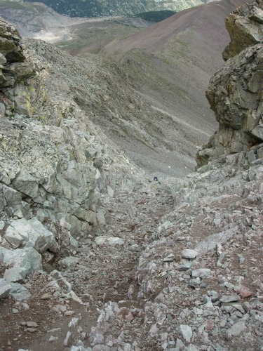
We slept at the trailhead Friday night with about 6 or 8 other 4wd's and a Dodge Stratus. I don't know if it was a rental or what, but I wouldn't take my car up there. Started hiking at 4:10am. There has been a lot of rain around the area recently so there are a number of little side streams that you have to cross at the beginning of the hike before you get to the one large stream crossing. The large crossing was easy for us with trekking poles . There were a bunch of nice stable logs that acted as a reasonable bridge. I would use a waterproof boot for this hike if you do it any time soon. The trail was, at times, difficult to follow as it climbed steeply through the trees near the boulder field. This may have had something to do with the fact that we were using headlamps at that point since it was so early in the morning. The trail continued up to tree line as we paralleled the gully, which had a profusion of wildflowers blooming along its length . The trail became much easier to follow once we hit tree line at the top of the gully and descended into a nice open alpine meadow. From the saddle between Iron Nipple and Lindsey there was a good trail up to the gully on the north face. It was loose and scree filled. I enjoyed glissading down it a lot more than climbing up it. With all the loose rock people have to be very careful of dislodging large rocks down onto climbers below them during this section of the climb . From the top of the gully we turned right and ascended back to the West ridge. This section of the hike was good class 3 stuff. We put the trekking poles away at that point and used our hands a lot until we gained the ridge. Once we made the ridge we followed a good trail to the false summit, and then on to the real summit. On the false summit we met 2 guys with their dog who had tackled the west ridge. If the dog, a chocolate lab, could climb the ridge then I'm sure I could have done it too. Maybe next time. Either way, we reached the summit about 9am. The descent via the gully was a lot of fun, but I did have to communicate with the other climbers below to determine who would go first. We descended quite slowly, stopping to rest and take pictures frequently. The weather held pretty well, but there were reports from climbers we saw on the way down that they got some hail up top after we left. We got back to the truck around 2:30. All in all this was a very enjoyable hike. The upper section, no matter which route you choose, is not for the faint of heart though. While there is virtually no exposure in the gully, it is still some good class 3 climbing and scrambling.
Thumbnails for uploaded photos (click to open slideshow):
Comments or Questions
Caution: The information contained in this report may not be accurate and should not be the only resource used in preparation for your climb. Failure to have the necessary experience, physical conditioning, supplies or equipment can result in injury or death. 14ers.com and the author(s) of this report provide no warranties, either express or implied, that the information provided is accurate or reliable. By using the information provided, you agree to indemnify and hold harmless 14ers.com and the report author(s) with respect to any claims and demands against them, including any attorney fees and expenses. Please read the 14ers.com Safety and Disclaimer pages for more information.
Please respect private property: 14ers.com supports the rights of private landowners to determine how and by whom their land will be used. In Colorado, it is your responsibility to determine if land is private and to obtain the appropriate permission before entering the property.