Download Agreement, Release, and Acknowledgement of Risk:
You (the person requesting this file download) fully understand mountain climbing ("Activity") involves risks and dangers of serious bodily injury, including permanent disability, paralysis, and death ("Risks") and you fully accept and assume all such risks and all responsibility for losses, costs, and damages you incur as a result of your participation in this Activity.
You acknowledge that information in the file you have chosen to download may not be accurate and may contain errors. You agree to assume all risks when using this information and agree to release and discharge 14ers.com, 14ers Inc. and the author(s) of such information (collectively, the "Released Parties").
You hereby discharge the Released Parties from all damages, actions, claims and liabilities of any nature, specifically including, but not limited to, damages, actions, claims and liabilities arising from or related to the negligence of the Released Parties. You further agree to indemnify, hold harmless and defend 14ers.com, 14ers Inc. and each of the other Released Parties from and against any loss, damage, liability and expense, including costs and attorney fees, incurred by 14ers.com, 14ers Inc. or any of the other Released Parties as a result of you using information provided on the 14ers.com or 14ers Inc. websites.
You have read this agreement, fully understand its terms and intend it to be a complete and unconditional release of all liability to the greatest extent allowed by law and agree that if any portion of this agreement is held to be invalid the balance, notwithstanding, shall continue in full force and effect.
By clicking "OK" you agree to these terms. If you DO NOT agree, click "Cancel"...
Took a little tour of the big M the "old fashioned way", as they used to say on the Smith Barney commercials- & I definitely earned the miles, some great Class 3 experience & also a few minor aches. Here‘s a brief summary of the hike:
Start on CO Trail at the Mt. Massive TH - 2:15AM
Junction with Mt. Massive Trail - 3:15AM
Saddle between Mt. Massive & South Massive - 5:30AM
Mt. Massive Summit - 6:15AM
Break 15 minutes to enjoy the sunrise
Massive Green Summit - 7:10AM
North Massive Summit - approx 8:30 (I kinda lost track of time coming thru the Class 3 pinnacle section)
Pt 14169 - approx 9:00AM
South Massive Summit - 11:00 AM
Start descent - 11:15AM
Back to Mt. Massive TH - 1:45PM
This trip as a prep for Longs Peak, which I will attempt later this summer. I used a headlamp until I reached tree line & then the 3/4 moon provided sufficient light for the nice trail. Leadville was beautiful at night and I also got to see the International Space Station, which was lit up on the eastern horizon prior to sunrise.
This was my first Class 3 experience (west side of pinnacles) and while it is not nearly as long as the Longs Peak section it did require a fair amount of route selection and had a few spots with decent exposure. One thing I did learn with Class 3 is to make sure you look up while climbing - I bonked the top of my head on a boulder.
Even more exciting than the Class 3 work was the kickstepping (and finger punching?) that I did on the snow-filled couloir at the eastern side of the pinnacles. I didn‘t feel like coming back thru the west side on my return and I noticed footprints thru the snow while on Massive Green. Unfortunately the snow had warmed up enough that the existing footprints were not suitable (at least 1/4 of the way thru this route when I was already committed). I wouldn‘t recommend this for the faint of heart as I was up a 45 degree slope with rock below.
Neither Bill nor Gerry Roach address the mileage & elevation for this route but I‘m guessing it was around 17-18 miles & 5500 feet in elevation (if anyone has better info please let me know).
I was going to start at the Windsor Lake TH however I was not comfortable with the route finding up to the Continental Divide at the lake during the middle of the night. There are also several lakes in this area & I didn‘t want to start off with wet feet.
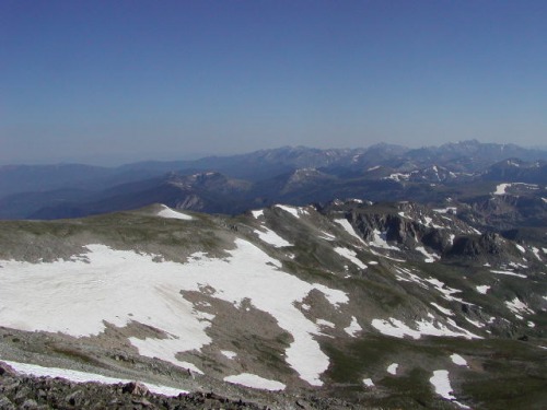
Here are some pics of the trip:
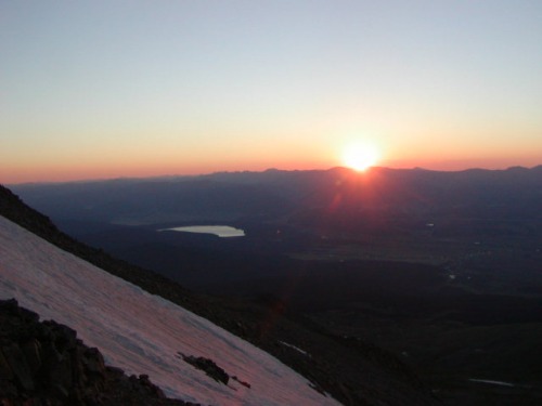
Sunrise near the summit of Mt. Massive with Turquoise Lake in view
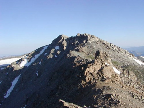
Upper route to Mt. Massive summit above saddle with S. Massive
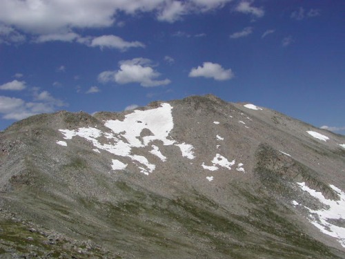
North Massive & the pinnacles from Massive Green
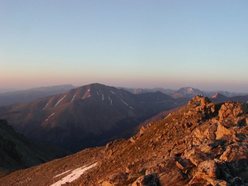
Mt. Elbert & La Plata Peak to the south
Continental Divide with trail down to the Windsor Lake TH
Thumbnails for uploaded photos (click to open slideshow):
Comments or Questions
Caution: The information contained in this report may not be accurate and should not be the only resource used in preparation for your climb. Failure to have the necessary experience, physical conditioning, supplies or equipment can result in injury or death. 14ers.com and the author(s) of this report provide no warranties, either express or implied, that the information provided is accurate or reliable. By using the information provided, you agree to indemnify and hold harmless 14ers.com and the report author(s) with respect to any claims and demands against them, including any attorney fees and expenses. Please read the 14ers.com Safety and Disclaimer pages for more information.
Please respect private property: 14ers.com supports the rights of private landowners to determine how and by whom their land will be used. In Colorado, it is your responsibility to determine if land is private and to obtain the appropriate permission before entering the property.
")
")
")
")
")

