Download Agreement, Release, and Acknowledgement of Risk:
You (the person requesting this file download) fully understand mountain climbing ("Activity") involves risks and dangers of serious bodily injury, including permanent disability, paralysis, and death ("Risks") and you fully accept and assume all such risks and all responsibility for losses, costs, and damages you incur as a result of your participation in this Activity.
You acknowledge that information in the file you have chosen to download may not be accurate and may contain errors. You agree to assume all risks when using this information and agree to release and discharge 14ers.com, 14ers Inc. and the author(s) of such information (collectively, the "Released Parties").
You hereby discharge the Released Parties from all damages, actions, claims and liabilities of any nature, specifically including, but not limited to, damages, actions, claims and liabilities arising from or related to the negligence of the Released Parties. You further agree to indemnify, hold harmless and defend 14ers.com, 14ers Inc. and each of the other Released Parties from and against any loss, damage, liability and expense, including costs and attorney fees, incurred by 14ers.com, 14ers Inc. or any of the other Released Parties as a result of you using information provided on the 14ers.com or 14ers Inc. websites.
You have read this agreement, fully understand its terms and intend it to be a complete and unconditional release of all liability to the greatest extent allowed by law and agree that if any portion of this agreement is held to be invalid the balance, notwithstanding, shall continue in full force and effect.
By clicking "OK" you agree to these terms. If you DO NOT agree, click "Cancel"...
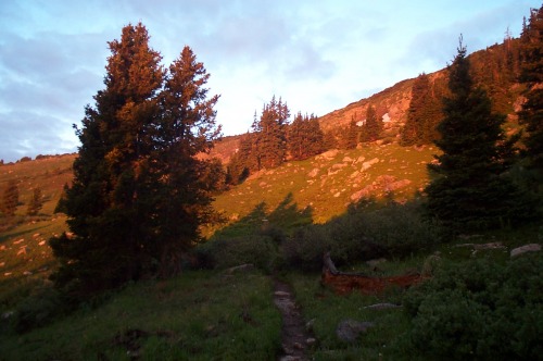
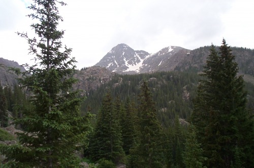
I spent the night before at the FS campground near the Tigiwon Community Center (actually an empty site on a holiday weekend). I left the Fall Creek trailhead around 4:30 am knowing it would be a long day during monsoon activity. The first several miles of the route are pretty gradual but the elevation gain increases once you reach the Notch Mountain trail. Fortunately, the scenic possibilities also increase as you make your way up the east face of Notch Mountain. Hitting the flower-flecked tundra at sunrise was spectacular.
Hitting treeline as the sun sneaks over the horizon is always a special treat.
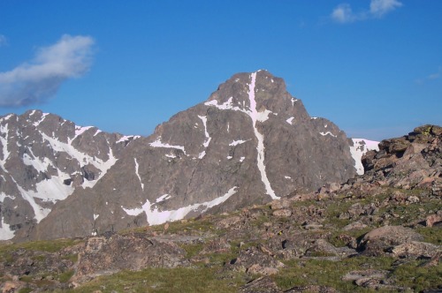
The trail up Nothc Mountain switchbacks enough that the grade never gets overly challegning. I arrived at the Notch Mountain shelter around 7:00 am. The view of MHC from the shelter is fantastic. The snow-filled cross was well defined and the basin between the shelter and the goal/summit is spectacular.
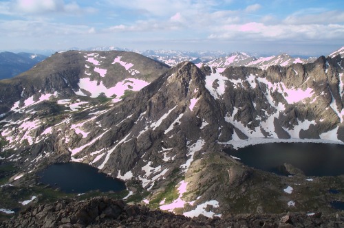
This view of the namesake cross on MHC is only available to those want to log the extra miles on the Halo Ridge route.
I then began the looooong ridge traverse toward MHC. There is no trail, it is almost pure talus-hopping the entire way. Very slow going indeed.
The views from Halo Ridge are spectacular along its entire length with the Tuhare Lakes the eye-catching feature to the south.
I finally intersected the standard route coming up from the north ridge and soon after, was on the relatively crowded summit around 10:00 am (Why was I 20 years older than everyone else up there?).
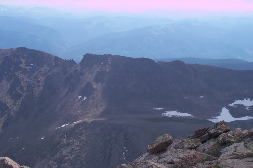
If the Notch Mountain Shelter (left center on the ridgeline) looks a long ways away, it is not deceiving! Lots of talus between the shelter and the MHC summit.
After enjoying the spectacular views from the top, I dropped down the north ridge on the standard route. Or at least I tried. There are only short trail segments and they seemed to get scantier the further I descended. All of the previous talus walk had taken its toll and the descent is probably not as steep as it felt. I was actually relieved to hit Cross Creek and be able to climb back up the other side toward Half Moon Pass! I returned to the trailhead at 2:00 with #39 an indelible memory.
The view of MHC from Cross Creek on the return side of the loop helps illustrate the distance and elevation gain that this hike requires.
Thumbnails for uploaded photos (click to open slideshow):
Comments or Questions
Caution: The information contained in this report may not be accurate and should not be the only resource used in preparation for your climb. Failure to have the necessary experience, physical conditioning, supplies or equipment can result in injury or death. 14ers.com and the author(s) of this report provide no warranties, either express or implied, that the information provided is accurate or reliable. By using the information provided, you agree to indemnify and hold harmless 14ers.com and the report author(s) with respect to any claims and demands against them, including any attorney fees and expenses. Please read the 14ers.com Safety and Disclaimer pages for more information.
Please respect private property: 14ers.com supports the rights of private landowners to determine how and by whom their land will be used. In Colorado, it is your responsibility to determine if land is private and to obtain the appropriate permission before entering the property.
")
")
")
")
")

