| Report Type | Full |
| Peak(s) |
Unnamed 13486 - 13,486 feet Unnamed 13513 - 13,513 feet Unnamed 13221 - 13,221 feet "Pear Peak" - 13,459 feet "Magdalene Mountain" - 13,780 feet |
| Date Posted | 10/05/2026 |
| Date Climbed | 10/03/2026 |
| Author | yaktoleft13 |
| Additional Members | handonbroward |
| Sawatch Scramblin |
|---|
|
Route: 13486 E ridge -> ridge to Pear Lake -> Magdalene N ridge Trailhead: Clohesy Lake Miles: ~13 (gps got a little wonky on the ridges) Vert: 6800 Time: 14 1/2 hours Difficulty: 4th class I have been out of climbing commission almost all summer. My wife and I had our second daughter in late July, born a few weeks early. A short NICU stay and learning to live life with two little girls has pushed the mountains not to the back burner, but entirely off the stove. The groggy mornings due to sleeping in the back of the 4Runner and 4 AM alarms have been replaced by groggy mornings because of triple feedings, overnight wakeups, squeaking babies, and dirty diapers. Dad mode has been fully activated for 2 1/2 months. But the fire is still there, so eventually the mountain pot's going back on the heat. My wife granted me permission to get back out into the mountains the first weekend of October (which to her credit is way earlier than any sane human would allow), so after creating a list of a number of routes I wanted to get done, I recruited Brandon to come along. We had a couple of routes on our radar. I didn't know what I wanted to do at first, but I knew it was going to be BIG! We initially settled on a dizzying ridge linkup in the Sangres. However, after watching the weather and checking webcams Friday morning, we elected to do a last-minute audible to the Clohesy Lake ridgeline, which we attempted to undertake in an ambitious December climb last year, only to get shut down on top of Huron by nasty winds (in hindsight, this was a good thing). So I drove down to the Rockdale trailhead Friday night, eager to test out a new platform/mattress I built to up the sleeping setup in the 4Runner from a one to a two star hotel, and promptly passed out. Brandon met me at 4:15 (or at least that when I woke up). I boiled some water for coffee, accidentally kicked said water over once boiling, boiled some more water, made coffee, revved up the 4Runner, and drove up the Clohesy Lake road to the upper gate. The obstacle getting out of the creek crossing wasn't too difficult; someone had stacked rocks on the edge of the rock step, which really took the teeth out of it. I didn't need 4LO at any point on the drive, but had those rocks not been there, probably would have for the rock step. After a few last-minute preparations, we loaded up the packs and set off from the parking area, promptly losing the trail 3 minutes into the hike. A little off-trail walking led us back to the trail, which we followed for a half mile or so until it was time to leave the trail for good. We turned off at a flat spot and navigated through some willows to reach the creek crossing, which was flowing pretty well and had no obvious place to cross. We searched for a little while and found nothing, before deciding we'd build our own little bridge to cross it. We draped a 3 inch diameter log across the entire stream, buffered by a couple of smaller logs next to it.I tested it, and SPLASH! Left foot straight in the water (to be fair, I weighted the wrong log). I regrouped, tried again, and our 3 inch thick log held well enough for me to stretch out across the river to the large rock marking safety...SPLASH! Said rock was icier than Queen Elsa's ungloved hands. Right foot's turn for a swim. But at least I was across! I wrung out my socks as I watched Brandon negotiate the logs with much more grace and make it across with much less wet feet. From there, we started the climb and bushwhack in earnest. There was an open area which was covered in willows and small evergreens, then a wooded area that had much larger downed trees. We attempted to stay in the willows primarily, which weren't that tall and had occasional game trails zigzagging through them, but ended up a little all over the place, including just plowing though the shoulder-height willows. In the grand scheme of bushwhacks, it really wasn't too bad, but it definitely was a bushwhack. Once above the willows and trees, we ended up on a grassy slope. Originally, I'd scoped out a fairly mellow gully on the north side of 13486's east ridge as our ascent route, but given the snow conditions decided against it early on, as the north side would be holding significantly more snow. We also had a route on the south side of the east ridge as a possibility, which is what we were planning on as we popped out of the trees. But dead ahead, option number 3 appeared: a little gully that lead to a bowl up to the east ridge directly, which would allow us to climb the whole east ridge and get a little warm-up in before the main event began. A quick consultation with Caltopo confirmed there were a couple of good bailout options to the south side route if the ridge didn't go, so with that knowledge we attacked it head-on. 

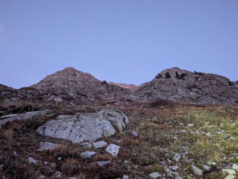
As it turns out, we made a great choice! The gully lead to a broad bowl, which had some slabby climbing up to the ridge proper. A little 3rd class later, the sun hit is and we were blessed with views of the entire ridge to the summit, including the crux just a short section away. 

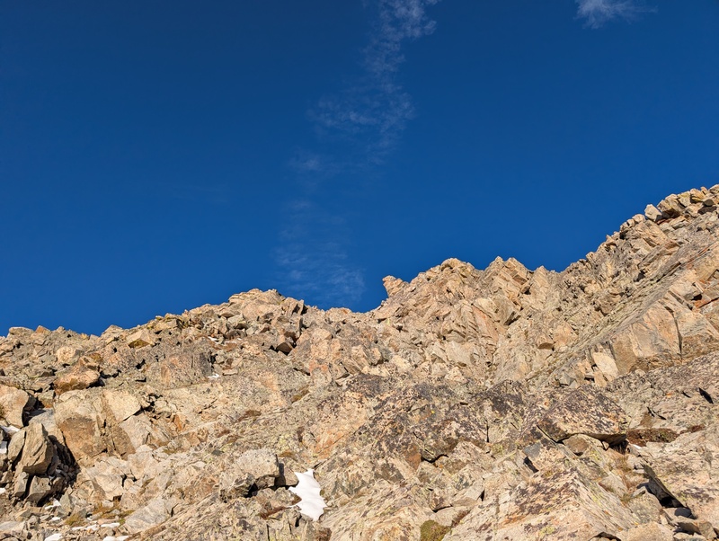
The crux of the east ridge was a steep inset gully/chimney, split at the top half by a rock rib, with a bit of an arete out to the right, providing an alternate ascent route if needed. From a distance, it looked quite daunting, but as I got up to it, the angle wasn't quite as vertical as it appeared and it was quite featured. I climbed up the right of the two splits in the gully, and while a bit of care was needed, the climbing never exceeded 4th class. Brandon also had no issues and soon we were both above the crux, scrambling along the primarily 3rd class ridge. As we neared the upper mountain, the defined ridge became more of a jumble of steep rocks. These also climbed at 3rd class, and when we topped the jumble, we were on the northern false summit, just a few minute's scramble away from the true summit. We scampered the ridge over to 13486, and stood on summit #1 of the day! 


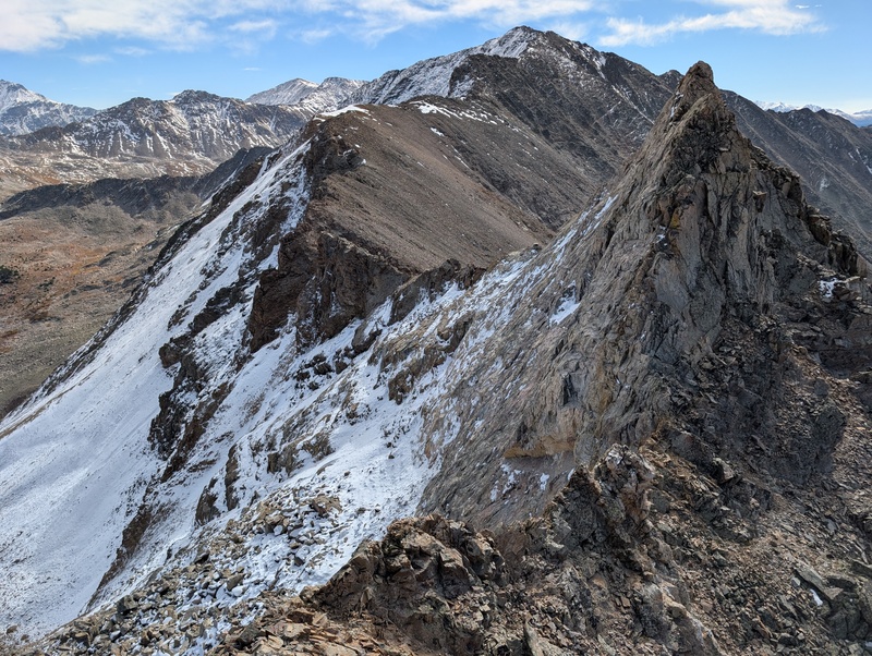
Immediately after leaving 13486, things got serious. 13513 is quite close to 486, but right away it was clear that there were three exposed, narrow towers that needed to be dispatched just to reach the saddle. Brandon led us over and down the first one at 4th class without incident, but the second one looked even more exposed and even more perilous, so from the saddle between the first and second tower, we elected to try to bypass the second and third to the west, as the east side was seriously exposed and cliffy. 

Initially, the western bypass went well, and we were quickly past the tower 2/3 saddle up above. But as we proceeded further, the climbing became more difficult and exposed, and as we reached the final corner we needed to surmount to get past the 3rd tower, our ledges ran out and we found ourselves seriously cliffed out. Do not pass go, do not collect $200, do not reach saddle. It was clear there was no way to that saddle from where we were on the west without backtracking, dropping 3-400 feet, and climbing up from the basin. Instead, we backtracked to the tower 1/2 saddle and checked out the east side. It was incredibly steep, but there were some grassy ledges a hundred feet down, with one ledge in particular looking like it might reach past tower 3. We thought this sounded way better than the western option, so we descended the slabby, grassy ledges, stemmed down a 4th class chimney, and worked our way down to the right ledge, hoping it would get us where we needed to be. And it did! Though there was 300 feet of sheer drop to the left of the ledge, the ledge itself was several feet wide and while covered in a bit of snow, quite secure. It led us right past tower number 3 to the saddle between 486 and 513 with one step-across move, and finally we were able to begin our ascent of the next peak. 


As soon as we started up 513, we knew we were in for a treat. The ridge was a narrow spine of rock that stuck out prominently from the rest of the mountain, and was largely snow free despite being north-facing. Once we started moving, we found the ridge to be essentially medium to hard 3rd class, with good exposure, bomber rock, and engaging movement. We stayed directly on the ridge top the whole way, relishing every inch of the 300 foot climb to the top of the ridge, where all too soon it ended, leaving us a few snowy steps and 30 feet of climbing to reach the summit. Though very close together, the combination of our routefinding error, difficult scrambling, and required care meant it took us over an hour to connect the the two unnameds. 


We took a break on the summit to refuel and rehydrate. Though we'd already summited half of our planned ranked peaks, we knew the day was just beginning. A long stretch of ridge separated us from our next target, the unranked unnamed 221, and Pear seemed positively unreachably far away. The section of ridge over to it didn't seem to be as spiny as what we'd just undertaken, but shortly after leaving 513 we encountered another tough 3rd/4th class downclimb. The rest of the ridge to the unranked peak was 2+/3rd class ridge scrambling, with frequent large exposure to one side or the other. There weren't any cruxes in this section, but the scrambling was consistent and real. The final push up 221 held some blocky scrambling, and we were surprised to find our first summit register of the day on the unranked, with just one signature. The dates in the register weren't clear, but it was either placed two weeks earlier or 3 years earlier (the person wrote both 23 and 26 as the year and they otherwise had completely illegible handwriting, so who knows). 


We didn't linger long on top of 221, as a quick glance toward Pear (which was finally getting closer!) revealed a ridgeline that seemed to be amping up in difficulty again. There was also an obvious pinnacle on the ridge that seemed likely to require 5th class climbing, sans bypass. Our experience matched our observations, as we found increasingly serious scrambling as we descended 221 toward the Pear saddle. At one point, we were forced to descend a nearly vertical 30 foot wall to the east, which was fortunately incredibly solid and featured in the right places. We continued scrambling along the ridge until we reached the pinnacle. Up close, it looked likely to go at easy 5th class, but given that we had no beta and couldn't see the back of it, we elected to explore the bypass rather than get cliffed out and have to downclimb what would have been our most difficult climbing of the day. And once we looked around to the southwest, lo and behold we found a cairn! It marked an easy but loose ledge traverse, followed by a short scramble led back to the ridgecrest. I explored the back of this pinnacle and found that it went at 3rd class, so for the next person to do this route: if you make it up the northern side of the pinnacle, the downclimb is easy. 


After passing the pinnacle, the ridge looked to mellow out for a bit, but having eyeballed the ridge from a distance, we knew better. There was a notch hidden just beyond the pinnacle that again would block easy travel to Pear. The ridge proper to the notch does not go, but dropping to the southwest resulted in a steep, loose downclimb; unpleasant, but doable. We carefully tiptoed down the rotten rock to the notch and up the other side, where once above the difficulties we found the easiest section of ridge we've had all day (and even a game trail!). After a brief respite of game trail and tundra, the ridge ramped back up to 2+/3 climbing with huge exposure to the east for the final push up Pear. But given the terrain so far today, this made it one of the easier sections we'd had all day. We topped out on Pear with all smiles, thrilled the Pear was still ripe. 


The rest of the day was supposed to be easy, or so we thought. Down the east ridge of Pear, down to the lake so Brandon could refill the half-cup of water he carried, then up to the pass and over to Magdalene. The upper east ridge held a couple of sections of mandatory snow, which were more supportive than one would expect on October 3rd. They were just deep enough to get the socks wet again, but otherwise posed no difficulties. Once past those, the ridge developed into an entertaining class 2+/3 catwalk, with occasional short 3rd class downclimbs and upclimbs. Nothing on the ridge was technically difficult or required thoughtful movement, but it was a cool position to be on such a pronounced catwalk for so long. But it just, like, never ended. Just on and on and on and on. After what felt like hours (probably 30 minutes or so in reality), we finally arrived at a break in the monotony: twin towers that blocked easy access to the lower ridge and the slopes to the lake below. This section all sort of blended together, and I failed to get pictures of a couple of important parts (oops), so the following is going strictly off of memory. The first tower looked difficult to climb, until we spotted a cairn on the east side (which was now the right side, after being the left the rest of the ridge. Not confusing at all). We followed the cairns and they marked a 3rd class sneak. This led to a climb back to the ridge, then a difficult and awkward 4th class downclimb on fractured angled rock just to the west of the sharp ridge crest. Then, a climb over the ridge and down a couple of well-placed holds led to a simpler traverse to the saddle between the towers. This little section was one of the sketchier of the whole day. From the saddle, we descended a loose gully about 25 feet to the east, then followed cairns to wrap around tower 2 and back to the ridge. A hundred or so feet of 3rd class downclimbing finally ended the difficulties, and at a small grassy saddle we were able to point our shoes toward the lake and hike straight down. This was a convoluted section and difficult to describe, particularly with no pictures to illustrate the words. Just trust; it's weird, but it goes. 


A long break was in order down at the lake, where we stopped at a little feeder stream for Brandon to refill water. We finally committed to full shirt and shorts, after waffling on layers all day whenever the breeze slightly picked up or the sun dipped behind a cloud for a second. I took down about 800 calories and after a half hour, we were ready to rock. Our plan was to get to the Emerald/Magdalene saddle and figure out if we were taking the standard route or wanted to explore the ridge. From across the valley, the ridge looked pretty manageable. The climb up to the saddle was aided by the rejuvenating feeling of sunlight on pale thighs. We reached the saddle quickly, and upon looking into the Pine Creek basin, there appeared to be a lot of snow and talus to deal with, as most of the standard route to Magdalene was north or northeast facing. I talked Brandon into trying the ridge (whoops), so we set off along the crest for one more scramble. 
This...did not go well. After navigating around the first couple of towers, I ran into a short but narrow buttress with an awkward step-up and 200+ feet of vertical exposure to the west (and not a lot better to the east). I wrapped around to the east and climbed a 5.easy chimney with some pockets of snow and ice in it to return to the ridge. As I looked to see what was next, I couldn't see an obvious way past. Everything had massive exposure and 5th class climbing, and to top it off the rock quality in this area had gone to pieces (literally). Brandon, in his infinite wisdom, had waited below the buttress for me and asked how it looked ahead. "Uh...not great!" A quick chat reached a consensus: this wasn't the way. We elected to backtrack to the saddle and regroup on the standard route. I very delicately climbed down the buttress and followed Brandon back to the saddle, where the snow-dusted talusy route in front of us had never looked so good. 
Tails slightly between our legs, we gave up the 300 vert to reach the rocky slopes that lead to the lake (which I have now learned is called Silver King Lake...the more you know!) and the ridge up to Magdalene. While annoying, the snowy talus section wasn't as long as we anticipated, and we ended up on some grassy tundra to stroll over toward the lake and our ascent route. As we did so, we peeked forlornly back up at the Magdalene ridge and were surprised (and not) to see that there were multiple towers with sheer drops visible from our location. It didn't look like that from over on Pear! We agreed that while maybe one could find bypasses around all of the difficulties if one dropped low enough, the ridge proper probably isn't going without rappels and gear, or balls (or ovaries) of steel. 

We approached the lake on the gentle terrain, lamenting how the entirety of Magdalene's north ridge was the second worst terrain in the world: snow-covered talus (scree over hardpan, you're still the worst). From the lake, we knew it would be 1,100 feet of trying not to find hidden trapdoors to reach the summit of our last peak. Our legs were pretty cooked, but I set Brandon the challenge of summitting in 45 minutes. Could we do it? (no) The talus hopping certainly wasn't fun or easy, but it was helpful that there wasn't that much snow up there yet. It filled in all the cracks, but the tops of a lot of rocks were sticking out. As such, we were able to talus-hop our way up the ridge, staying 95% on dry rock that only shifted under our weight sometimes. Slow and steady was the mantra, and while we lived up to the first part, the second was a little harder. Nevertheless, we made upward progress and eventually reached the junction of the north ridge with the northeast (summit) ridge. Due to the aspect, this part was a wee bit less snowy, so with one last push we pressed on to the summit, number 4 and our last of the day! I checked the watch: 49 minutes. What a failure. 


Views were incredible from the summit. It was massively rewarding to gaze out over the north and realize we'd traversed just about everything we could see that day. But the day's not done until the car's on, and we were still a long ways from the 4Runner. After eating nearly all our food, we reversed our route down the snowy talus as carefully as possible. I, having snapped a pole earlier in the day (when do I not?), used a combination of right hand pole, left hand planted on the stablest talus I could find, feet trying not to slip. Pretty? No. Effective? Yep! We safely made it back down to the lake, not much quicker than our ascent, and stopped to filter water one more time. 
We'd kind of been dreading the regain to the pass, but it wasn't really too bad. The gentle terrain leading to the talus/scree slope below the pass went quickly, and the last couple hundred feet of gain were more solid than expected. We topped out on the pass, traversed down and to the north, and eventually made it to the bench that slowly dropped down to Pear Pass and the long-desired trail. 
Once at the trail, we made a snack exchange: I'd brought too much sweet, and Brandon brought too much salty. I traded my gummies for a few teriyaki sticks, and we set off down the meandering trail, snacks and ibuprofen in the bellies. After a while, the fuel kicked in, and the tired legs were brought back to life, to the point that we felt pretty strong as we turned the headlamps back on. In the dark, we kept tricking ourselves into thinking every depression to the west was Clohesy Lake and that we were almost done, but the trail seemed to go on forever. We knew we were close when we saw the shimmering of a campfire on the lake to our left. But not without one last complication, we somehow missed our trail turnoff and ended up on a low trail next to the lake, forcing us to bushwhack a few hundred feet back up the hill through the avalanche area to finally reach the car, about 14 and a half hours after we left. We quickly tossed our gear in and rattled our way back down the road to Brandon's car, where we wished each other luck in finding a store that would still be open for food and said our goodbyes. This day was fulfilling. The route was full value, much more so than I anticipated, but was never overwhelming. It was a bit of a death march at the end, but once done, I can't help but look back on it with fondness. And it was satisfying to get back out with Brandon to the ridge that turned us back 10 months prior and to complete it. I'd told Brandon during our planning that I wanted an epic return to the mountains, and man! We nailed it. 
Thumbnails for uploaded photos (click to open slideshow): 






|
| Comments or Questions | |||
|---|---|---|---|
|
Caution: The information contained in this report may not be accurate and should not be the only resource used in preparation for your climb. Failure to have the necessary experience, physical conditioning, supplies or equipment can result in injury or death. 14ers.com and the author(s) of this report provide no warranties, either express or implied, that the information provided is accurate or reliable. By using the information provided, you agree to indemnify and hold harmless 14ers.com and the report author(s) with respect to any claims and demands against them, including any attorney fees and expenses. Please read the 14ers.com Safety and Disclaimer pages for more information.
Please respect private property: 14ers.com supports the rights of private landowners to determine how and by whom their land will be used. In Colorado, it is your responsibility to determine if land is private and to obtain the appropriate permission before entering the property.