Los Perros to Grey Campsite:
8.54 miles (13.75 km) | 3,259’ (993 m) elevation gain
| Report Type | External |
| Peak(s) |
Patagonia |
| Date Posted | 05/05/2026 |
| Date Climbed | 02/08/2026 |
| Author | Kiefer |
| Additional Members | ReginaThomas |
| A much delayed honeymoon |
|---|
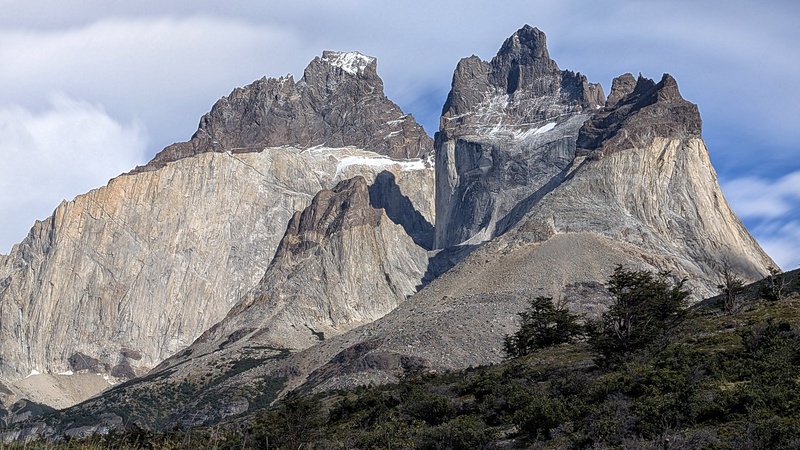
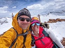
This trip was our honeymoon, many years late. We married during Covid and with most borders being closed or Draconian entry requirements being enforced elsewhere, we decided to wait until things calmed down. But due to work obligations (I swear, work is ALWAYS messing things up!) and the complexity of travel to Patagonia, we had to put this off until earlier this year. All I really knew about Patagonia, was the dramatic pictures you always see in your computer screen-savers and from watching a movie I have called, "Mountain of Storms," about Yvon Chouinards' & Pete Athens' efforts to start their namesake company. Nothing I really knew could have prepared me for what I encountered and experienced. I was so impressed and in awe of Patagonia, that we're returning next year (2027) with a stop at Easter Island. We're actually looking into buying a small flat in Puerto Natales. And of course, it doesn't hurt that we met Tommy Caldwell & Siebe Vanhee as they were coming off their famous climb of the S. African Route on the Central Pillar at Base Torres. We hiked a 56+ mile circuit known as the O-Circuit in Torres del Paine National Park. Then spent several days exploring more of Patagonia by car including Tierra del Fuego. I'm posting this as an external report because of the sheer size of this. It took me two weeks to just post it, to say nothing of writing it. Hope you enjoy! Torres del Paine National Park is one of 46 National Parks and 45 National Reserves in Chile. It is also, one of the busiest, most sought after and most regulated in Chile. This part of the country takes conservation to a level that should leave the NPS here in the States embarrassed. For example, since 2012, the National Forestry Foundation (CONAF) that maintains a large chunk of the Magallenes region, reported 52 expulsions (~152 individuals) of people from the National Park (most for smoking in prohibited areas). Most of these come with fines upwards of $6,800 USD and in some cases, lifetime bans to the National Park System and prohibited entry into Chile for three years. The measures are in place because of a fire that was started by an Israeli tourist in 2011/2012. That fire burned upwards of 22,000 acres (8,903 hectares). So, with the blessings of the Chilean Government, the CONAF and local law enforcement have a 0% tolerance policy. And in my readings, they don’t back-paddle or rescind penalties. Torres del Paine National Park has two main hiking circuits that tourists typically utilize. The first and by far & away, the most popular, is called the ‘W-Circuit.’ This is a 43-mile, multi-day hike involving well-maintained trails that takes in spectacular views of the Torres del Paine Towers and Los Cuernos Mountains. Nights can be spent camping in tents or for additional fees, elevated tents (plataformas) or even indoor lodging at the many refugios can be had. Trekkers can be entirely self-sufficient with food or go “full-board” meaning, meals are cooked and served to you in the refugios; again, for a hefty price. The W-Circuit takes in most of what is generally referred to as the front side of the National Park. And even if one chooses to do this truncated version, the views are still delicious! You’ll be sharing the trail (and refugios) with people from all over the World. Campsites quite literally sell out within a matter of hours after going live with reservations. And, oh, yeah. Reservations are MANDATORY. Not only does Park Staff keep track of who is where in the park (they’re big on safety & accountability), but there is a daily allotment of people in the park and you must check in every night to each camp you stay at. Failure to do this can result in fines and expulsion, so have your passport number handy. The other hiking circuit is the ‘O.’ This loop circuit comes in at around 75 miles and other than taking in the whole ‘W’ circuit, this also circumnavigates both the Los Cuernos and Torres del Paine Massif. You get to experience the wilder, backside wilderness. Expect to spend about 8-9 days doing this. This option typically isn’t as popular as it requires a longer time commitment, more advanced hiking skills and honestly, hiking up and down John Gardner Pass was CONSIDERABLY more involved than I expected, especially for a pass that doesn’t exceed 4,000’. The expected elevation gain (and loss) is around 16,000’ and I hope it goes without saying, this is definitely the more challenging & difficult of the two. The country is more remote, you get to see lakes, mountains and another glacier that one doesn’t see when hiking the ‘W.’ It’s generally more peaceful, quiet and less people. This is what Regina and I choose. And honestly, just getting to Patagonia is an epic undertaking on its own. 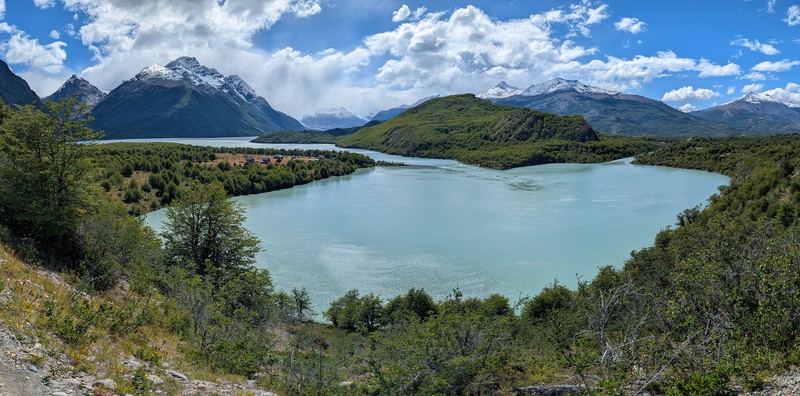
Monday Feb. 9th Getting up before the roosters start their morning calls is always hard. So, the wee hours were a blur of routine & last-minute checks. But trust me, as I was sitting on the plane flying further south to the tip of South America, I was drooling over that beverage cart the stewardess was pushing anticipating that black, caffeine-laden nectar. The mountains from 27,000’ in the air, as we cruised further south, looked like butchered, white cake frosting. We landed in Puerto Natales at 9:00 am. We scurried off the plane, filed across the windy tarmac and into the single gate airport. Once we secured our duffel from baggage claim, we rounded up a shuttle to take us to the Best Western. We checked our bag, confirmed our “upcoming stay” with the hotel and promptly ordered a taxi to take us into town. As an aside, I will say, knowing at least a rudimentary knowledge of Spanish goes a long way with the taxi drivers and shuttle transportation. We had a MUCH better grip of Spanish than that. I’m not fluent by any stretch, but I can communicate more than, ¿Dónde está el baño? and ¡Más cerveza ahora, por favor! After we obtained what we needed in town, we caught a taxi back to the airport. Why the airport you ask? Because that’s where our private shuttle was picking us up. We only waited perhaps 30 minutes before a small, black car pulled up. In broken Spanish/English, we became well-introduced and loaded his car up with our packs and sped north to the National Park under growing clouds and darkening skies. An hour later, we pulled into the Park Headquarters to check in. It was actively raining. There wasn’t much to see and the building was eerily empty & quiet. After ascertaining and checking our permits, we piled back into his car for the remainder of the drive to the visitor Center (also referred to as Central). It rained the entire 15-minute drive and was still raining while we were taking shelter inside the building with other fellow trekkers (presumably who had just finished). I kept watching a saturated & sodden hiker who was wandering around. He looked like a cross between a Grateful Dead hippie, hair clippings from a barbershop floor and Peter Petigrew (from Harry Potter). Not able to keep it contained any longer, the stifled smile on my face exploded. Regina managed to secure us a table in the cramped quarters while I procured us a pisco sour and a calafate sour. But also, to wait out the rain. A bus pulled up whisking everyone away back to Puerto Natales and left only a few us behind. Another 10 minutes or so of waiting, rewarded us with a light drizzle (at best). It was time. It was time to hit the muddy trail. And this would end up being the only instance of rain for the entire week. Central Sector to Seron Camp: 7.88 miles (13 km) | 980’ (299 m) elevation gain We left the visitor center following a short-cut heading straight up the hill behind the building. This social trail connected to a road which turned into the official trail. It was still cloudy and drizzling. But thankfully, despite the occasional puddle, the trail itself wasn’t too muddy. It was fairly easily to follow despite there being a lot of satellite trails and threading in the area. However, the farther from Central we hiked, the trail threading stopped and paired down to a singletrack. The rain came and went but it never really down-poured. The terrain was mostly low forest. Broken patches of meadow meandered through the forest like an indecisive animal. We were slowly gaining elevation off the valley floor. It was warm and muggy; but nothing horrible. We were still a bit in awe of actually being here, hiking in Patagonia which, I think falsely led to bloated ideas of the views being better than they actually were. Because of our late start and that the weather was still unpredictable, we were hiking at a decently fast pace. We wanted to make Camp Seron before the weather decided to REALLY start to rain. However, we took the weather in stride. Patagonia is known for its weather. And to be honest, I wasn’t too impressed with this first segment (as mentioned). The gnarled & ancient-looking trees were definitely interesting, but the views were on the meh side. If anything, the clouds added to what I felt was a stagnant & brackish atmosphere. We strolled into Camp Seron quite literally within minutes of the rain seriously picking up. We got the tent set up under heavy rain. Thankfully, our bags and pads were still dry. We threw everything into the tent helter-skelter and rushed over to the cooking tent to eat some dehy. meals. After we got the Jet Boil going, I ducked inside the refugio and bought a couple beers for Regina and I to have with dinner. It was weirdly cold out. Everyone in the tent was wearing fleece, puffy jackets and ski hats. And this was summer! This is also where we met our trail buddies, Amy and Byron from Manhattan. We would end up leap-frogging each other and sharing a lot of the same campsites. I instantly liked the both of them. We didn’t stay long in the cook tent. Regina and I were exhausted from the monumentally long day. With bellies full, we sauntered back to the tent under a heavy drizzle and climbed into our down cocoons. It was 9:00 pm and still light out, nothing a ski hat or eye covers can’t handle. 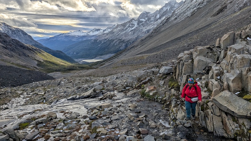
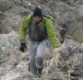
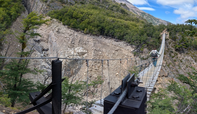
Los Perros to Grey Campsite: 8.54 miles (13.75 km) | 3,259’ (993 m) elevation gain This was a BIG day, no bones about it. Thursday entailed more elevation loss than gain. And the descent from John Gardner Pass is not for the faint of heart. Again, switchbacks for whatever reason, don’t exist on this trail. And THIS descent is where they would have been wonderful to have. There’s no need to install hand-lines (there were two) for a descent when crews can map and just shovel out switchbacks with appropriate erosional measures in place. The descent from John Gardner Pass to The Grey is the only part of the entire trek that would get me to not repeat this wonderful circuit. Expect a full-body workout for this leg. Our alarm woke us up at the ungodly hour of 5:30 am. I had a hard time sleeping as the wind sounded like freight trains roaring by. It was still dark outside and cold. I slithered out of my Western Mountaineering bag and sauntered over to the kitchen (cook room) to boil up some water for coffee. The Starbucks Via dehydrated coffee packets not only dissolve well (it’s a micro-grind), it actually tastes good. It’s always been my ‘go-to’ when camping. Regina and I snacked lightly while packing. She had some hot tea and we were off by 6:30 am, just as dawn was starting to claim another day. The departure trail from Los Perros is a steep & difficult affair to follow in the dark. Los Perros by the way, an odd name for this part of the wilderness, was named for a pack of wild dogs that used to live in the valley. The trail is marked by orange tags, but the abundance of tree roots, squelching mud and rock make the trail hard to pick out in low light. Make sure your headlamp is strong & bright. I noticed others were lagging behind us having difficulty following the path. Eventually, they just followed us until the dawn burned away enough of the dusk. They then overtook us which, was fine. This wasn’t a race. Even park staff doesn’t recommend leaving before first light. The elevation gain from Los Perros Campsite to John Gardner Pass is about 2,037’ over roughly 5 miles (give or take). Normally, this rise-over-run equation shouldn’t be anything to dread, the elevation gain is spread over a fair distance. But the abundance of mud, water on the trail and tree roots was insatiable. It was like walking through a snake den of roots. Progress was slow and frustrating, like learning a new language. After 45 minutes, we started to dart in and out of treeline like playing Whack-a-mole, until we left the forest all together. The trail turned into packed dirt, talus and rock; pretty much what one would expect for an alpine environment. Our progress and speed thankfully increased at this point. While I love the dark mysteries and details of the forest, it’s the alpine environment that I truly relish. There’s something about having sweeping vistas everywhere you look, trekking across hardscrabble land where most animals are just visitors (save for a precious few who actually live there), and the constant bombardment of the elements testing your resolve. In other words, it’s the kind of place that takes determination and perseverance to navigate successfully. And as we stepped into that forlorn place, the famous winds of John Gardner Pass immediately got to work. 
On November 17th of 2025, five people died in a worsening storm as they set off from Los Perros too late in the day with impending weather. Multiple groups ended up turning around but individuals got lost in the white-out, blizzard conditions. Winds were clocked at 120 mph and snowing. The ranger station at Los Perros was minimally staffed due to a mandatory voting day in the country. So, there really was no one available to tell people of the incoming weather or warn against leaving too late in the morning. Five people (two from Mexico, one from England & two from Germany) died from exposure/freezing. John Gardner Pass is notorious for wicked weather and sudden changes. It’s not advised to linger when trekking across the pass. And all this at only 3,600’. Who was John Gardner? John Gardner was the pioneer who basically unlocked the backside of Torres del Paine to make the O-Circuit possible. He was a member of a joint British-Chilean University Expedition. This was an undertaking by universities in the UK and Chile from 1957-1958. The goal of which, was to survey & map the more remote areas of Chilean Patagonia. Even during the late 1950’s, this area was still relatively unknown even to Chileans. Gardner, after several expeditions to the area, located a pass in 1975 that would connect the campsites/refugios of Dickson and Gray thus, completing a loop. The pass is named in his honor. Thumbnails for uploaded photos (click to open slideshow): ")
")
")
")
")
|
| Comments or Questions | |||||||||
|---|---|---|---|---|---|---|---|---|---|
|
Caution: The information contained in this report may not be accurate and should not be the only resource used in preparation for your climb. Failure to have the necessary experience, physical conditioning, supplies or equipment can result in injury or death. 14ers.com and the author(s) of this report provide no warranties, either express or implied, that the information provided is accurate or reliable. By using the information provided, you agree to indemnify and hold harmless 14ers.com and the report author(s) with respect to any claims and demands against them, including any attorney fees and expenses. Please read the 14ers.com Safety and Disclaimer pages for more information.
Please respect private property: 14ers.com supports the rights of private landowners to determine how and by whom their land will be used. In Colorado, it is your responsibility to determine if land is private and to obtain the appropriate permission before entering the property.