| Report Type | Full |
| Peak(s) |
Green Mountain, 9418' Little Green Mountain, 8827' |
| Date Posted | 02/22/2026 |
| Date Climbed | 12/23/2025 |
| Author | Gore Girl |
| The Sentinels of the Reservoir: Green Mountain and Little Green Mountain |
|---|
|
The Sentinels of the Reservoir: Green Mountain and Little Green Mountain Green Mountain, 9418’ – December 23, 2025 Green Mountain sits directly east of the Blue River, overlooking Green Mountain Reservoir at its northwestern end. The mountain doesn’t advertise its presence, merely observing the endless thread of travelers along CO-9 as the months and seasons unfold. I imagine this sentinel witnessing the times that I have passed by, enroute to remote excursions in the Sarvis Creek Wilderness of the northern Gore Range this past fall. However, today, two days before Christmas, it had my full attention. In a normal winter, I would have been gliding through the forest on skate skis at this time of year. Admittedly, though, the thought of being able to hike this late in the season without avalanche danger was enjoyable. Unlike many folks around these parts, I ski to stay in shape for hiking — not the reverse. I parked at the first pullout on the right of CR 30 (north side) after turning onto it from CO-9, intending to approach the summit from the ENE aspect. This parking spot appeared to be one that trucks use to pull in and then back across the road to a gravel pile on the opposite side. I situated the Jeep in such a way to be as unobtrusive as possible and not impede that process. When I looked up, the summit appeared to be right there as I crossed the powerline dirt road and forged my way up a gentle ridge. Threading myself through the clumps of sagebrush, I noticed its scent in the chilly morning air when brushing my way past its woody branches. 
The summit looks deceptively close. But the grabby sagebrush along the way necessitated some high-stepping to get there. “Ridge direct,” I thought to myself in describing the route, remembering my former piloting days and the routing terminology of that time. Air traffic controllers often cleared a pilot “direct” to their waypoint or destination, thereby allowing them to proceed by the shortest route. In similar fashion, I eyed the summit, pointed my feet roughly westward, and started walking. Around 8650’, the slope steepened appreciably, so I contoured to the south, intercepting an old 4WD road for a short way while continuing to angle upward. I circumnavigated the steep E-NE side of the summit — then, once clear of that, headed northwest directly up some loose rock to the summit itself. Sitting on the east side of the summit cairn for protection from the chilly breeze, I enjoyed expansive views in all directions. 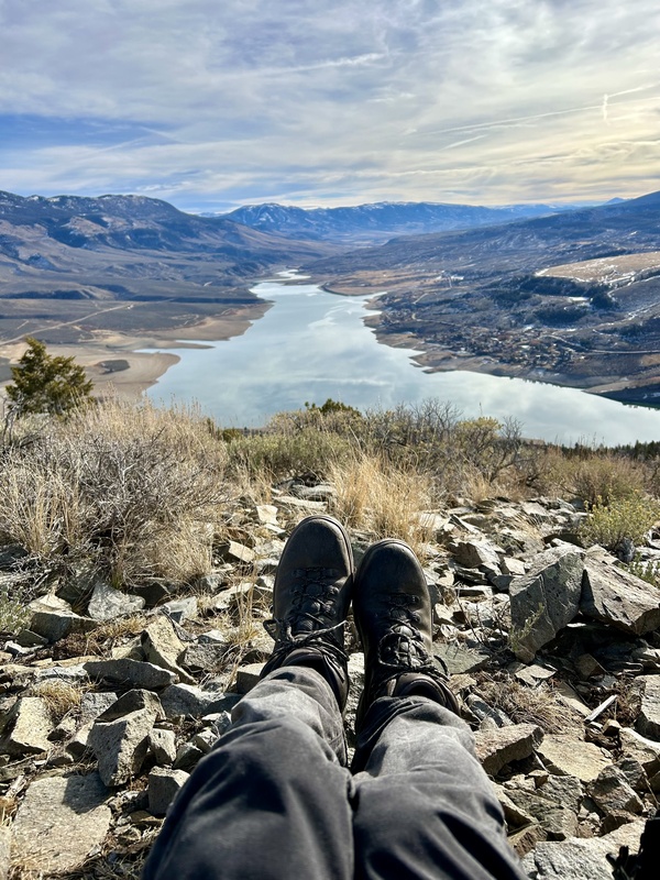
Looking southeast toward Green Mountain Reservoir. The sagebrush has liberally decorated my pants with dust. This photo is similar to one I took around 40 years ago on the Glen Boulder Trail in NH, which also prominently featured my leather boots. I also noticed the ridge crest of Haystack Mountain off to the left, the bulwark of Eagle’s Nest in front of me, and the level expanse of Elliott Ridge in the distance at right with the usual wind-loaded snow on its east aspect. 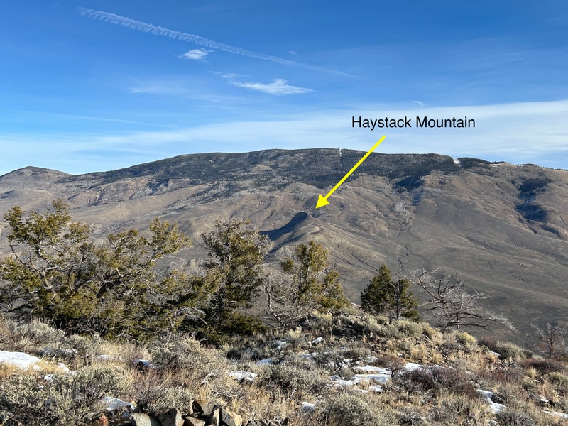
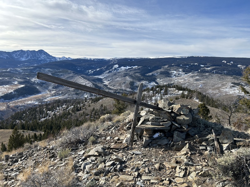
Summit cairn and remnants of control mark. Eagle’s Nest at left, and Elliott Ridge runs center through right in the distance. 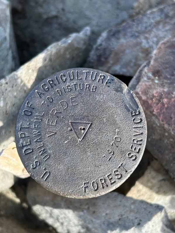
Verde Benchmark 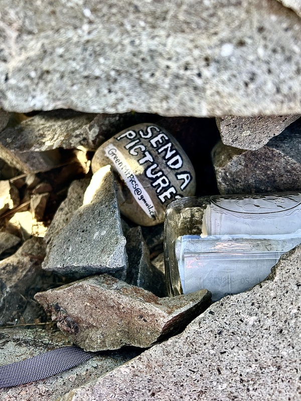
Painted rock and summit register tucked into the cairn. I wonder what the recipient does with the pictures received? I suppose I could write and ask. After a snack and recognizing some of the familiar names in the register, I departed the summit by its south ridge. Dropping into the trees, I then followed the top edge of an escarpment eastward. This ridge was an interesting feature in that it had a jumble of igneous rock with large crystalline inclusions scattered everywhere. I found myself staring at the ground much of the time, thoughtfully picking up a specimen or two, and considering each one as I turned it over in my hands. One of them found its way into my pocket and I named it “The Fickle Finger of Fate” as it had an interesting crystal sticking out of an edge. On the back side, it displayed brown needle-like inclusions as well as some that looked like the dark chocolate chunks in one of my favorite ice cream flavors. 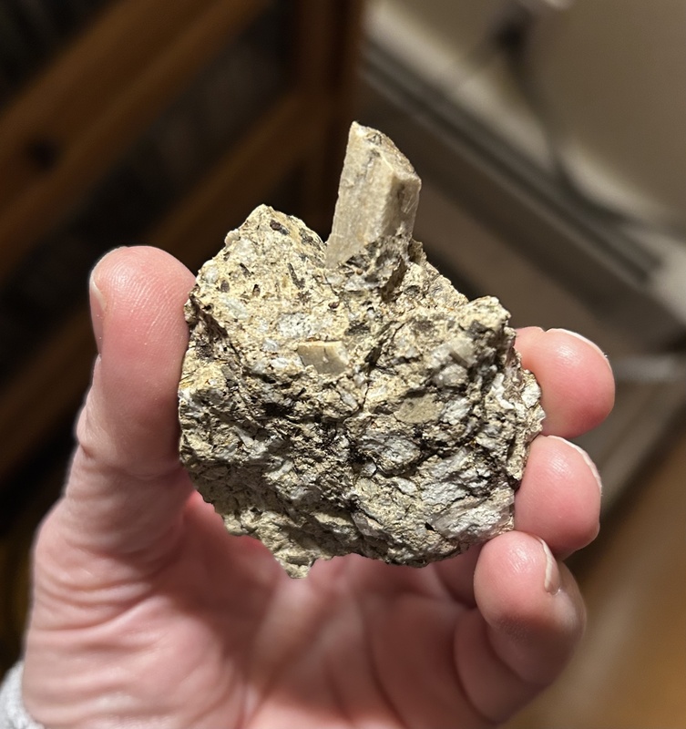
The “Fickle Finger of Fate” 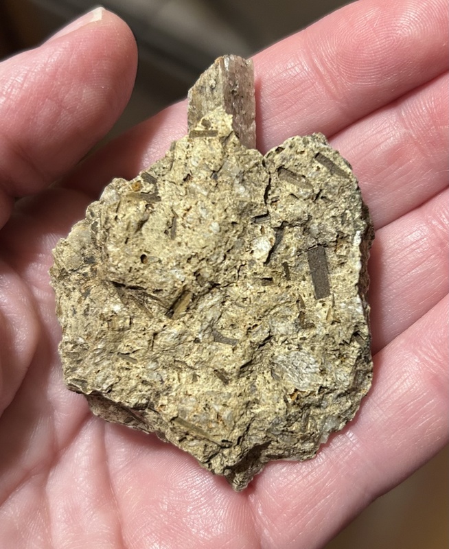
“Chocolate chunk” inclusions I continued along the escarpment dodging small patches of snow. Adjacent to one of these was what looked like a perfectly round stone. I tapped it with my hiking pole as I started to pass by — and then stopped abruptly when I realized something felt odd. This stone had some give, so I crouched down to take a closer look. 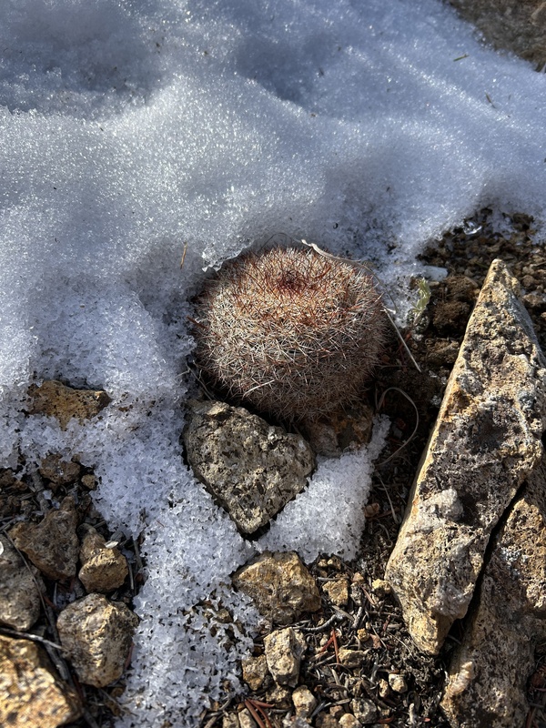
Not a stone at all! I felt bad that I dented its top right side with my pole. Upon closer inspection, I saw that it was covered with needles and realized it was not a stone but rather a cactus. I searched for others but couldn’t find any and wondered why it was the only one. Glad I didn’t accidentally sit on it, I thought, pausing for a moment next to the plant. I looked around a little more to see what else might be in the vicinity, then eventually moved on. Once down the ridge, my route intersected the 4WD road that followed the powerline and turned east back to where I had parked. I considered going over to Little Green Mountain afterwards but decided to wait for another day so that I wouldn’t be pressed for time there.
Little Green Mountain, 8827’ – December 24, 2025 Green Mountain’s smaller sibling is tucked below and to the west. Their respective landforms are bisected by the Blue River, with Little Green providing a viewing perch to the vertical rock cliff and pinnacles on the west and southwest face of Green Mountain. It is good that I came back for this one rather than trying to do both in the same day. Little Green Mountain has its own personality and atmosphere, so I wanted to take all the time needed to explore there. As it turned out, once I considered the near-term weather forecast after going to Green Mountain, the best day to come back for Little Green Mountain was the next day, December 24th. In studying the lay of the land in advance, there was a discrepancy in the mapped location of the private property lines. In one instance, the summit itself appeared to be on private property, but the landowner entity indicated on their website that the property boundaries did not include Little Green Mountain. If the landowner was convinced they didn’t own the summit, that was good enough for me. I brought a printout of the website image along in the unlikely instance anyone would question me. I needn’t have worried. There wasn’t another soul around. Being that it was sunny and much warmer than the prior day had been, I realized that it was good I had brought enough water. This is not the kind of thought one expects to have the day before Christmas, however. In preparing to head out, I looked up from the Jeep and could see the summit. As for Green Mountain, it appeared to be right there. However, it ended up taking me longer to get up Little Green Mountain than it did Green Mountain. 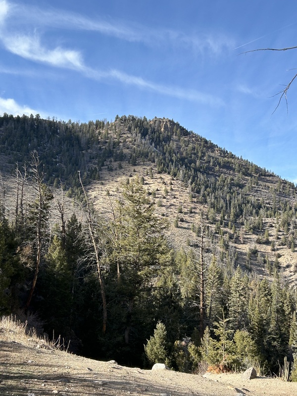
It’s just a few minutes that way…isn’t it? My first steps took me the wrong way up an old road from parking, but quickly realizing my mistake after consulting the map, I backtracked to my car. The only other logical way to go was to head down to the river. It seemed counterintuitive to be descending, especially as the slope leading to Blue River was short and surprisingly steep. This pitch was well-shaded and rarely had direct sun on it. Hence, it would tend to get slick and icy earlier and remain that way. I started to pick my way down, sidestepping tentatively as a fall here could be painful. I had poles with me and leaned on them carefully. The dirt underfoot had the consistency of frozen ball bearings and yielded easily. It took some effort to keep gravity from getting the upper hand. In concentrating so intently at what my feet were doing, I didn’t see the rope right away. Noticing a flash of color out of the corner of my eye, I realized that someone had anchored an industrial green rope to a tree and the rocks below. It was knotted at distinct intervals to assist one in getting down (and up) the pitch safely. Now that’s a first, I thought. How often does one have a rope leading down at the start of a climb? And it’s interesting that my day out on Little Green Mountain happened to begin with a green rope, no less. I surmised that the rope was likely fixed at that location by fishermen, for whom the Blue River was a popular spot. The smooth soles of the boots they wear would make it a necessity on a slope like this. However, I found the rope to be helpful to me also as I worked my way down, knot by knot. 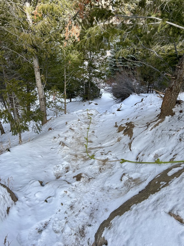
It would be wise to hold the rope on the way down….(pictures taken several days later after snow had fallen and improved the visibility of the rope) 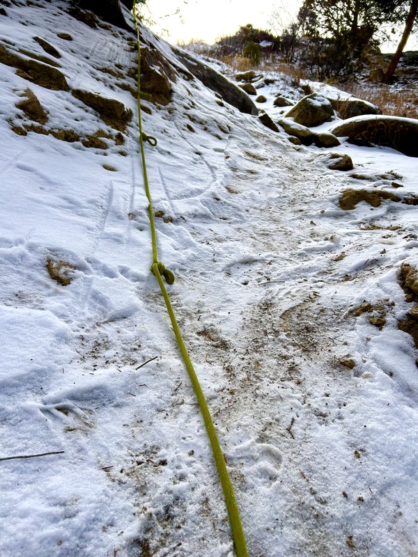
…because looking back up gives you an idea of the steepness! Once down at the level of the river, I followed a user trail until reaching a spot where the trees thinned out to my left. Entering this clearing, I then ascended a gentle ridge that curved to the WSW. I wished I could follow it to Pt 8625, but that was on private property, so I instead deviated northward, contouring below Pt 8625 and then turning to climb to the south ridge of Little Green Mountain. In ascending the final pitch to the summit, I noticed dozens of what looked like peppermint Life Savers strewn about in the dirt and reached down to pick some up. They were upside down snail shells, littering the ground all around me. I also remembered seeing them on Green Mountain, but there seemed to be many more over here. 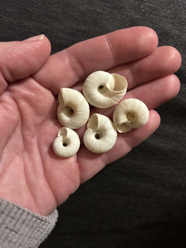
Scattered on the ground in bright sunlight, these looked like Life Savers! On the summit, there was a control point tower slightly north of a medium-sized cairn. A guy wire ran from the tower to one of the rocks of the cairn. Moving a few rocks around, I looked in the cairn for a register but did not see one. I also searched near the base of the wooden tower but did not find a register there, either. This was not surprising, as Little Green Mountain does not have a 300-foot prominence and therefore is unranked. From the posted climbs on Lists of John, it is evident that far fewer people are attracted to Little Green Mountain (versus Green Mountain) and this is the most likely reason. Going from the cairn to the tower, I tried to ascertain which had the higher ground underneath it. Finally deciding the land under the cairn seemed higher, I placed a register there. In looking down toward the river at a small dark speck below, I realized it was my vehicle. The summit had definitely looked closer from the Jeep — than the Jeep did from the summit. Before leaving, I sat down and ate lunch. The only noticeable sound was the “grok” of a raven as it circled above, perhaps attracted to the scent of food. 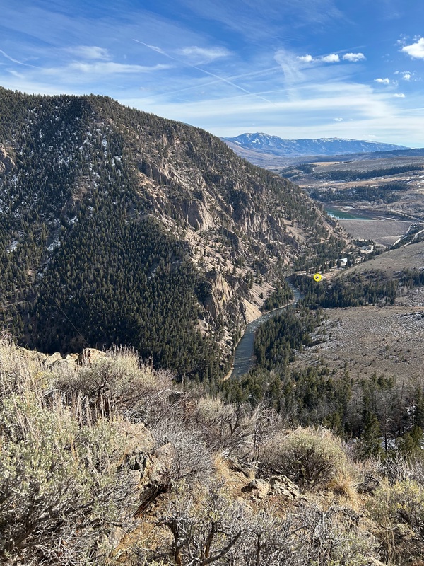
That microscopic speck in the center of the tiny yellow circle is my Jeep. View from the summit. On the descent, I took a more southeasterly course through the trees and down a steeper hillside. The dirt there was soft, so my route down consisted of sideslips. While moving through the trees, I noticed what looked like another set of footprints in the loose dirt. After making my way through some vegetation, it suddenly felt like my clothes were pulling at me. Looking down, I saw that I was covered in dozens of burrs…. 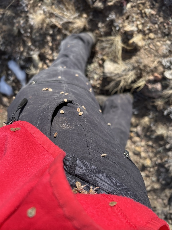
Burrs had attached themselves to my pants, shirt, jacket, pack, and pole straps. Everything was now sticking to everything! Once back on the user trail along the Blue River, I stopped at a rocky beach to take a break. It was peaceful listening to the water rush by while eyeing the thousands of rounded stones scattered there. “I’ll call this Pebble Beach,” I said aloud. Looking back up at the summit, I could just barely make out the wooden tower on top. Across the river, the impressive vertical cliffs bounding the southwest side of Green Mountain were prominent. This was a beautiful spot, and I made a mental note to come back next summer to enjoy a picnic here. 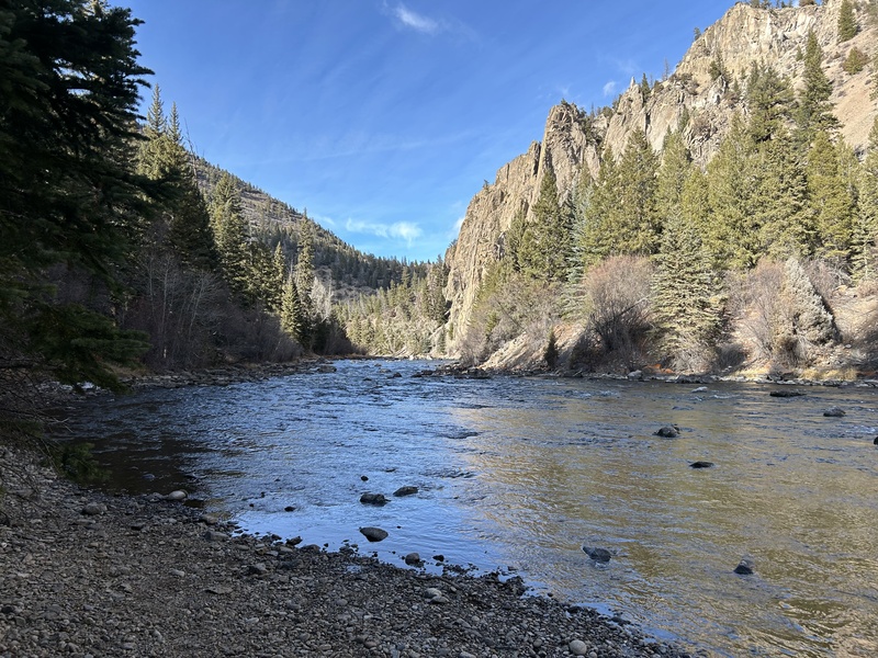
“Pebble Beach” along the Blue River; lower slope of Little Green Mountain is at left. The rocky pinnacles of the SSW side of Green Mountain are on the right. Just before arriving back at the green rope, I noticed an old stone fireplace buried in the weeds. I somehow missed this on the way in and wondered about its history — and whether it was from an old homestead. 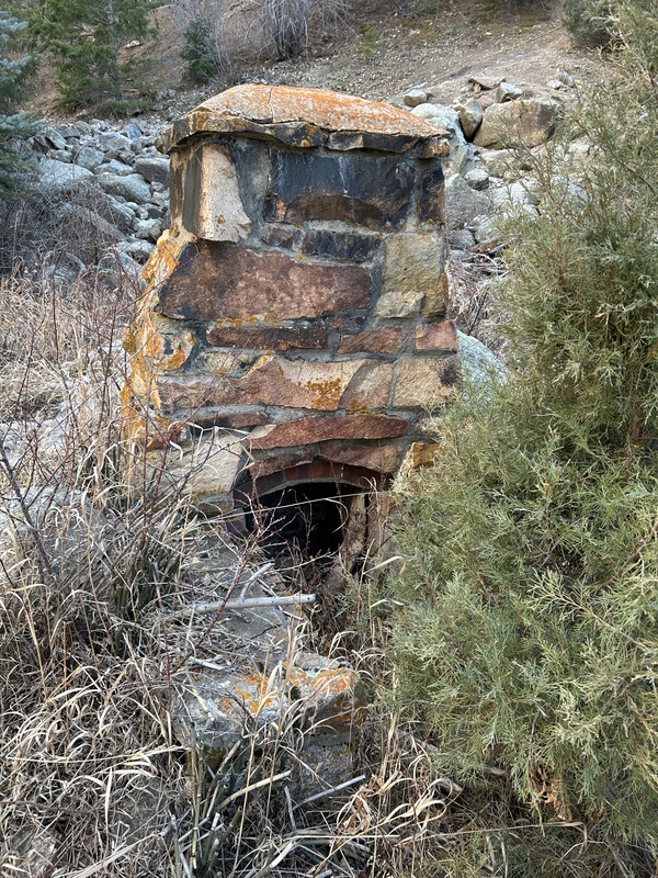
Glad I noticed this on the way back. It would be interesting to know more of its history. You can just barely see the bottom of the green rope at upper right of photo. Once back at the Jeep, I had to break out the tweezers from my Swiss Army knife and spend a solid half hour removing burrs from everything. Despite my attention to detail, two of them managed to hitchhike home with me on a sock, along with a few twigs in my hair – lingering traces from an interesting day of exploring. Thumbnails for uploaded photos (click to open slideshow): ")
")
")
")
")
")
")
")
")
")
")
")
")
")
")
")
")
|
| Comments or Questions | ||||||
|---|---|---|---|---|---|---|
|
Caution: The information contained in this report may not be accurate and should not be the only resource used in preparation for your climb. Failure to have the necessary experience, physical conditioning, supplies or equipment can result in injury or death. 14ers.com and the author(s) of this report provide no warranties, either express or implied, that the information provided is accurate or reliable. By using the information provided, you agree to indemnify and hold harmless 14ers.com and the report author(s) with respect to any claims and demands against them, including any attorney fees and expenses. Please read the 14ers.com Safety and Disclaimer pages for more information.
Please respect private property: 14ers.com supports the rights of private landowners to determine how and by whom their land will be used. In Colorado, it is your responsibility to determine if land is private and to obtain the appropriate permission before entering the property.


