| Report Type | Full |
| Peak(s) |
Pt 9731, 9731' (LiDAR) |
| Date Posted | 01/11/2026 |
| Date Climbed | 10/09/2025 |
| Author | Gore Girl |
| Additional Members | gore galore |
| 9731: The Hidden Tower and a First LiDAR Ascent |
|---|
|
9731: The Hidden Tower and a First LiDAR Ascent by Gore Girl Preface: It is exhilarating to contemplate first ascents in the present day, as the initial and subsequent climbing activity in the late 19th to mid-20th century in the Gore Range already established first ascents on many of the most distinctive peaks. Few have encountered opportunities to climb a summit block that has probably known no other visitors. To find the overlooked, the forgotten, the unknown — is, in my impression, a worthy pursuit. The Hidden Tower: Enter 9731. It sat quietly in the Sarvis Creek Wilderness, an unassuming presence of the northern Gore Range biding its time. Once in a long while, it heard the sound of voices in the distance at its sister summit, 9722, and then inevitably, listened to them recede. And 9731, with its impassive stone face, then continued its solitary watch towards the “Rabbit Ears” to the north. For one isn’t going to notice this peak easily. There are two reasons for that. First of all, a map wouldn’t easily have shed light on 9731. On a topographic map, it is represented by one contour line yet would not be differentiated from 9722's contour. And on a Forest Service map, no contour line is displayed at 9731. While there, gore galore and I estimated the tower which comprises the summit is about 30 feet high, and the contour line appeared to be right at the base of it. Hence, as far as maps go, the existence of that rock summit was therefore entirely obscured — as the next contour line wouldn’t have appeared on any map unless the tower was at least forty feet high. The presence of 9731 was first determined and published by John Kirk on 9/22/25 by evaluating LiDAR data. gore galore noticed the addition of the peak as a new LiDAR summit with 0 ascents noted on Lists of John and mentioned it during our exploration of Lone Spring Butte on 10/2/25. I evaluated a possible route and satellite data that evening and proposed a visit. It was clear from my review that the summit was rocky, but the exact proportions were not yet obvious. 
Satellite image shows 9731 as a rocky, finlike prominence from above, unseen from 9722 due to the extent of trees. A DEM (digital elevation model) overlay only hints at its existence and does not distinguish it from the spot elevation 9722 itself. Darker shading indicates higher elevation, but discrimination between 9722 (which has a new LiDAR elevation of 9718) and 9731 is impossible. 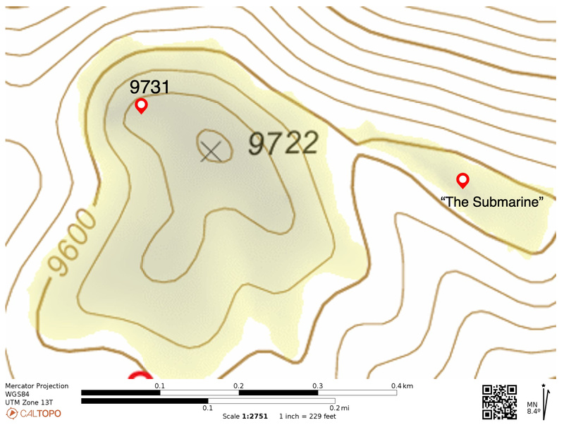
Gray shading at 9731 and 9722 on the DEM overlay indicates higher elevation than the surrounding yellow areas. However, it isn’t fine enough to distinguish one from the other. Note that the basemap here is a Forest Service map, which does not have a contour for 9731. Furthermore, 9731 cannot be seen from 9722 itself. Peak baggers had come to 9722 in the past and had not noticed it lurking quietly behind the trees, nor found it through exploration. This is due to the fact that for most of them, 9722 was not considered a sole destination in and of itself, but as part of a list of objectives on any given day. So arrival at 9722 was often followed by a reversal in course to the next summit as opposed to scouting around. Additionally, the nondescript nature of the random boulders at 9722 itself would not have invited much exploration. It is probable that 9731 had been noticed by hunters but questionable by climbers. Approach: We hiked the Sarvis Creek trail from its eastern terminus for three miles and then bushwhacked up a soft ridge to 9573. Luckily, the density of deadfall was low, so our progress was steady and relatively unencumbered the entire way. We then proceeded across a flatter section that finally ascended to 9722. Despite looking in several locations among the boulders at that summit for a register, we did not find one. It was also noted when scanning in the direction of 9731 from 9722, we were not able to see 9731 through the trees. However, as we arrived there, the summit block suddenly appeared: 
My first thought was: I wonder how we’re getting up there? It deserves a closer look…. 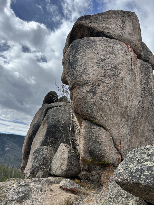
Approaching from the north, it welcomed us with a benevolent, yet somber “face”. Upon arriving at the north end, we circled to the right (west) where two possible routes to the summit presented themselves: a vertical crack midway along the west side of the feature, and further along, a ledge on the south side. gore galore checked holds on both of these but found them suboptimal. Returning to the north end, we explored further to the east side of the tower and found a chimney/gully that looked more promising. The first move involved getting over a bulge. Once beyond that, a few left angling cracks and ledges led to a final mantle move to reach the summit. We took turns at ascending the tower in order to spot one another for safety at the bulge; gore galore investigated the summit first and I followed his route afterwards. We used no ropes, as we found the climb within our abilities. gore galore also placed a summit register neatly in a crevice near the summit block. The 360-degree view from the summit was airy and expansive, showcasing other singular and interesting rock features across the wilderness. 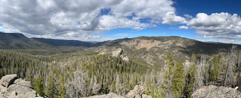
Looking west across the Sarvis Creek Wilderness from the summit of 9731. We returned via a parallel route down the ridge east of our ascent ridge. This gave us a closer look at a rock feature east of our course that we dubbed “The Submarine” due to its shape. 
Metrics: The distance from where we left the Sarvis Creek Trail to 9731 was about 1 ¼ miles. 9722 to 9731 is about two tenths of a mile. Total RT distance ~ 8.4 miles. Afterword: Our journey to this remote and infrequently visited area of the Sarvis Creek Wilderness gave us a rare and unique opportunity to make a first LiDAR ascent of 9731. Recognizing its existence by climbing its monolithic summit was profoundly satisfying. On a final note, I considered the experience from the vantage point of the peak itself: the voices it once again heard in the distance as we approached — arrived this time. Thumbnails for uploaded photos (click to open slideshow): ")
")
")
")
")
")
|
| Comments or Questions |
|---|
|
|
Caution: The information contained in this report may not be accurate and should not be the only resource used in preparation for your climb. Failure to have the necessary experience, physical conditioning, supplies or equipment can result in injury or death. 14ers.com and the author(s) of this report provide no warranties, either express or implied, that the information provided is accurate or reliable. By using the information provided, you agree to indemnify and hold harmless 14ers.com and the report author(s) with respect to any claims and demands against them, including any attorney fees and expenses. Please read the 14ers.com Safety and Disclaimer pages for more information.
Please respect private property: 14ers.com supports the rights of private landowners to determine how and by whom their land will be used. In Colorado, it is your responsibility to determine if land is private and to obtain the appropriate permission before entering the property.

