| Report Type | Full |
| Peak(s) |
Huron Peak - 14,006 feet Browns Peak - 13,526 feet Unnamed 13471 - 13,471 feet Middle Mountain - 13,062 feet |
| Date Posted | 01/02/2026 |
| Modified | 04/10/2026 |
| Date Climbed | 12/23/2025 |
| Author | CaptainSuburbia |
| Winter Huron and Lulu 13ers |
|---|
|
Winter Huron and Lulu 13ers From Cross Mountains Northwest Ridge 
Fresh off a successful winter Missouri Mountain summit, I decided to give Huron a try knowing 390 would be drivable to Winfield. I had a 2wd Elantra rental car and made it easily. My plan was to take the Lulu Gulch route and pick up it's 3 13ers along the way and then descend the standard route which had been trenched 2 days prior. However, after parking and seeing a dry ridge on the north side of Cross Mountain I decided to change course and try to climb that ridge to access the Lulu 13ers. I had climbed Lulu Gulch a number of years ago and wanted to try something different. I knew nothing about this ridge but from the road it looked like it would go, and then it would be more, or less, a straight shot across the Lulu 13ers to Huron. It was an impulsive decision to climb an unknown route, but on paper, it did look like a good idea. It worked out, but I don't recommend it over the Lulu Gulch route. Day of Climb: Tuesday, December 23rd, 2025 Peaks Climbed: Huron Peak, UN 13,471, Browns Peak and Middle Mtn Trailhead: S. Winfield/Lake Ann Mileage and Elevation Gain: Approximately 10 miles and 4,481 feet of elevation gain. 
I parked near the center of Winfield and started my climb at 7:30 am which is very late for a winter attempt. I walked south to the large 2wd parking/camping area and turned east walking through this area to access an old mining road that presumably would take me to the NW Ridge of Cross Mountain, or, at least it looked that way on the map. I easily found the snow covered road and started up it. I didn't bring snowshoes and luckily the snow was only ankle deep to start and never got much deeper. Surprisingly, this road appeared to be in good shape and deadfall was limited at first. Everything changed though at a ravine crossing. There was no bridge and no sign that it ever even existed. I crossed through it though without issue and the road immediately became more wild after. It never really got bad, just lots of young trees growing up in it and I was forced to climb over avy debris twice. 


After a couple switchbacks I left the comforts of the road at an elevation of 11000 feet and climbed a steep incline to reached what would be an almost never-ending talus slope. It would remain steep from here to the summit. Unfortunately, a cliff band blocked direct access to the ridge proper. I went to the right up a ramp to get by. I eventually hit another cliff band and found a rock gully to get through this one. Then it was a sea of talus to the upper ridge. Much of it seemed to be slowly sliding off the mountain so care had to be taken. 


I hit the upper ridge at 12,300 feet and was happy to get there. The final 500+ feet of elevation to Cross Mountains summit got much easier and it didn't take long to top out on this "high" 12er. Looks like I've got another list to start working on now🙂. The summit view towards the southwest of the Lulu 13ers and Huron was beyond impressive and the reason climbers enjoy climbing the Lulu 13ers. The rest of my route could easily be seen and it looked fun. I only stopped on Cross Mountain for a moment as I was eager to start the fun ridge run to Huron. 

Cross Mountain to the first Lulu 13er, Middle Mountain, took less than 15 minutes over easy terrain. Middle Mountain barely gets over 13,000 feet and is an unranked summit but still worth the visit. Unnamed 13,471 was next along this ridge line. It is ranked and is about a 500 foot vert climb from the saddle with Middle Mountain. The ridge was mostly dry. There was a lower summit then a short upper ridge led to the actual summit. 


13,471 was a nice 13er and has a fabulous view of Hurons East face. I signed the register and headed southwest off it's summit towards my next objective, Browns Peak, another unranked summit. Browns was not far away. The ridge to the saddle was mostly dry and went quick. I then headed up Browns mostly snow covered east ridge to the summit. My 4th summit of the day in quick succession. 


I dropped off Browns and reached it's saddle with Huron quickly. I then did the low traverse across a solid talus slope until it connected with the standard Northwest Slopes route of Huron. I followed this trail approximately 500 vert feet to Hurons lofty summit. I had the summit to myself and enjoyed the incredible views in all directions. The views of the Apostles and Ice Mountain are always impressive from Huron. 


It was a warmish mostly windless day, so I had a nice long summit stay eating lunch while taking in the views. Just as I left to descend the standard trail another climber summitted, and I also ran into a group of 2 a little lower down. Once off the upper mountain, there was quite a bit of snow and I was happy to see a solid trench to follow all the way to the 4wd trailhead. I then followed fresh tire tracks on the 4wd road approximately 2 miles back to the town of Winfield and my car. Total trip took 7:30. Thanks for reading! 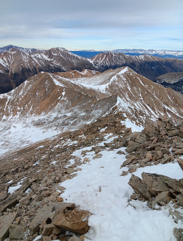

Thumbnails for uploaded photos (click to open slideshow): ")
")
")
")
")
")
")
")
")
")
")
")
")
")
")
")
")
")
")
")
")
")
")
")
")
")
")
")
")
")
")
")
")
")
")
")
")
|
| Comments or Questions |
|---|
|
|
Caution: The information contained in this report may not be accurate and should not be the only resource used in preparation for your climb. Failure to have the necessary experience, physical conditioning, supplies or equipment can result in injury or death. 14ers.com and the author(s) of this report provide no warranties, either express or implied, that the information provided is accurate or reliable. By using the information provided, you agree to indemnify and hold harmless 14ers.com and the report author(s) with respect to any claims and demands against them, including any attorney fees and expenses. Please read the 14ers.com Safety and Disclaimer pages for more information.
Please respect private property: 14ers.com supports the rights of private landowners to determine how and by whom their land will be used. In Colorado, it is your responsibility to determine if land is private and to obtain the appropriate permission before entering the property.

