| Report Type | Full |
| Peak(s) |
"S 4" - 13,256 feet |
| Date Posted | 12/14/2025 |
| Date Climbed | 09/04/2025 |
| Author | Marmot72 |
| S4 from Deep Creek |
|---|
|
S4 and S6 had been on my radar for years, always with the intent of early June snow, but, as they say, the stars never aligned. In 2025, wanting to get these with an early September week-long sojourn, I resolved to take the longer and less scenic approach from the west, up the Deep Creek drainage, since the Blue Lakes trail was still closed for reconstruction. With a questionable weather forecast, I didn't get as early a start as I should have, which is why this report covers S4 and not both S4 and S6. The Deep Creek trailhead is not far from a housing development lying north of Telluride proper, and a lone house stands only a couple hundred yards to the north. The road is a well-graded dirt road, suitable for regular cars. I had been here just the year prior, 2024, with Benners: we used this trailhead for our descent for our point-to-point hike of the "Western S's" to Mears. Ok, so while this approach does not go to the mesmerizing Blue Lakes, if one looks backwards at the right moment, there is something work looking at.
One logistic note: low down on this approach, the trail network can get confusing. Early up the Deep Creek trail, it will be intuitive to turn left, as the right-hand clearly goes southward and not to the desired valley. Soon after, a second left makes a urn to the NW. Do not take this left, but stay on what is now the Iron Mountain Spur trail. It connects to the main trail farther up and saves you 150 feet or so of unnecessary elevation loss. In contrast to the postcard vista behind me, the way forward seemed unappealing. The "U" notch was where I needed to get to, and it seemed farther away than I would like at 7:15 in the morning. The way ahead, as seen below, would involve more talus side-hilling (low angle, but tedious nonetheless), then some talus/boulder trudging (this side of the first set of white rocks in the picture), then a bit of low angle ridge hiking (the grassy top of a rock glacier) before a final push up a gully of large talus. Fun!
Just across this short talus field in the prior picture, the trail resumed and led beside the ruins of an old cabin.
After the cabin, the trail became worse, because of the expansive talus in this basin. There is a path through the talus and it's worth keeping to where you can. What you will learn in this journey is that the trail strays farther uphill on the north side of the valley than you would expect from looking at the map. Onward and upward, I told myself, and after another 45 minutes, I paused for another glance behind me, since the way ahead was uninspiring. The sun hit the top of the ridge to the north, and the stands of trees below it, and I fooled myself into thinking that storm clouds might not materialize after such a clear, beautiful morning.
As I continued moving eastward and upward, I arrived at the first pile of white boulders that I had glimpsed earlier, and they looked like they might be more stable than the rust-colored talus that stretched on interminably across all the slopes. When I reached them, I turned now left, going NNE instead of E. An hour had passed since I stood by the ruined cabin.
I ended up sticking to right where the white boulders met the red talus, as it went pretty easily. Afterward, I was relieved to find a change in the terrain - finally some tundra after all of the talus. Looking back down the way I had come, the terrain appeared much less tedious than I had found it to be underfoot. The clouds far to the west were building, and I cajoled myself to move faster to the pass.
Methodically, I made my way to the gully that led to the pass, and up it. Dry, it was not terrible and I just made my way upward. When I reached the saddle, this was my view ahead to S4. I pondered it for a couple minutes, trying to trace the best way up its loose face festooned with buttresses.
From this vantage, I quickly determined that the two feasible options would be either 1) left of center, to the prominent tan patch and up or 2) right of center, between the "first and second' of the three buttresses going center to right. With either option, I would progress to the final push in the light, just right of the shadowy portion left (west side) of the summit. This descent off this side of the pass was decidedly easier than the ascent from the other side. As I hastened forward, the mountain loomed large in my vision and I lost my bearings so that I was not sure which of the two previously-decided options I took. I think I went up option 1 and down option 2. I didn't pause for pictures on my way up, but did for a couple on the return, so here they are: First, the way up/my look back at my exit from the cliffband:
Second, as I made my way down from the upper ridge, this was my view as I headed back westward, with the S4/S6 saddle in the distance. While this view is opposite of the view one would see on the ascent, I have included it in case the terrain in the foreground and relative position to the pass will help with bearings. (Unranked S5 is the pointy peak right of the U shaped pass, and Mears rises formidably to its right.)
This mountain is among the looser of the San Juans; it's not great rock. The cliff band involved solid class 3, but nothing more. Maybe it's because I've now climbed hundreds of SJ peaks, because the looseness did not frighten me, and I didn't find it to be miserable. But this is a stout peak. Part of my brain was saying "wow, this peak is pretty rotten" while part of my brain was just enjoying moving upward and looking forward to topping the summit. Soon after the navigating the gullies of this broken cliff band, the way forward looked like this:
I was not sure how close I was to the summit, but I was close: it ended up only taking 13 minutes to reach the summit register from when I took this picture. Just before the tippy top, the passage grew narrower, blockier, and more exposed, but still, no harder than class 3.
On the summit, I enjoyed a double delight. The first surprise was the register, from 1933, when this peak was known as Wolcott Mountain. Wolcott now refers to unranked point to the west. In my mind, I saw these men and women in their wool clothing, the women in skirts and not pants and none of them with any footwear that facilitated anything close to the sure-footedness and efficacy of shoes we enjoy today, and I felt both awe and humility.
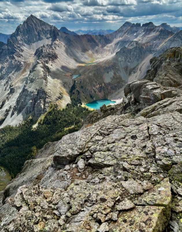
Unlike the register, my second source of joy was not a surprise. I had anticipated the view of Sneffels and the Blue lakes the whole way up, and I was not disappointed. From the summit, I zoomed in with the camera and took this shot of Sneffels and the larger of the two upper Blue Lakes.
Then I jogged eastward and downward from the summit for a better view that included all three blue lakes. It's funny how much terrain is hidden by the picture above: the valley in the next picture is like a whole county. Not really, I know, but what I'm getting at is how expansive relatively small areas are when you experience them on foot - on trail or off. It's one of the joys of hiking to see how full the wilderness is.
Back to the summit, I gazed south, to Gilpin and Emma and the peaks on the ridgeline on the far side of Governor Basin. Then it was time to hurry back to the pass, in an effort to get S6 before the stormclouds rolled in. It was 11:35 am and I liked my chances. (If only I were still in my 30s, and not my 50s.) 
Looking along the ridge and sky line to the way back westward appeared formidable, but of course, I would be dropping to traverse the upper basin to the pass.
When I dropped off the left, I found myself in a different gully than what I took on the way up. This gully was characterized by dark red/rust and brown colored rock. It was fairly steep, narrow, and inset, and very short: only forty feet or so. While I don't have a shot of the gully, here is a look again to the west from the base of the gully (this pic was shown earlier to give an idea of the terrain I traversed to reach the ridge west of the summit). 
It was now shortly before noon; I had spent 10-15 minutes on the summit and another ten getting over and down this gully. It would take me another 40 minutes to regain the pass and then the day was done: the sky had darkened and I was in for a torrent. As I picked my way down the west side of the pass, the wind launched the graupel into my face. Graupel is fine; it doesn't hurt like hail, it's not wet like rain, and it doesn't cloud vision like snowflakes. But I waited midway down from the pass, in hope that that the storm might move through quickly to allow me get to the top of S6. I crouched miserably behind a large boulder that failed to completely block the wind and the moisture, as the graupel turned to rain. In addition to the precipitation, several flashes of lightning warned me against trying for a second peak. Resigning myself to a return trip, I gingerly picked my way downward, yet still managed to slip and fall on my right hip. Nothing but a nasty bruise, but it lingered for a solid week. I've been fortunate that I've not been weathered off mountains that often. What made this endeavor harder to forsake was that I was pushing to finish the Colorado 13ers by September 27. That goal was not a given, and getting both S4 and S6 on this outing was a requirement to meet that time table. Continuing down the basin with the rain seemingly falling straight at me from a 45 degree angle rather than overhead, and with thoughts of my failed 13er finish filling my head, I can't say that my spirits were high. I consoled myself with thoughts that S4 had been magnificent and that it's not a bad thing to "have to" return to the mountains. When I neared the bottom where the trail runs along the canal, the water had reached nearly as high as the trail. The day had not ended as expected, but it had ended in a way I knew could be possible, and, prior to the storm, it had been a stupendous day. I went to bed that night contented with another fine experience in the majestic San Juan mountains. Thumbnails for uploaded photos (click to open slideshow): ")
")
")
")
")
")
")
")
")
")
")
")
")
")
")
 Lizard Head and the Wilsons")
|
| Comments or Questions | ||||||
|---|---|---|---|---|---|---|
|
Caution: The information contained in this report may not be accurate and should not be the only resource used in preparation for your climb. Failure to have the necessary experience, physical conditioning, supplies or equipment can result in injury or death. 14ers.com and the author(s) of this report provide no warranties, either express or implied, that the information provided is accurate or reliable. By using the information provided, you agree to indemnify and hold harmless 14ers.com and the report author(s) with respect to any claims and demands against them, including any attorney fees and expenses. Please read the 14ers.com Safety and Disclaimer pages for more information.
Please respect private property: 14ers.com supports the rights of private landowners to determine how and by whom their land will be used. In Colorado, it is your responsibility to determine if land is private and to obtain the appropriate permission before entering the property.