| Report Type | Full |
| Peak(s) |
Fremont Peak: 13,754' The Sphinx: 13,277' |
| Date Posted | 10/14/2025 |
| Date Climbed | 08/16/2025 |
| Author | jfm3 |
| Wind Rivers Mini Camp |
|---|
|
Wind Rivers Mini Camp August 14-16, 2025 My out-of-Colorado mountain trip this year was in the Wind River Range in my home state of Wyoming. I grew up in Casper and made many trips to the edges of the Winds over the years: camping near Lander, driving through Dubois on the way to Jackson, cross-country ski racing near South Pass and at White Pine above Pinedale. This trip was the first time I climbed any summits in the Winds. I was at home in Casper in early August, and fit this 3-day excursion in before returning to Boulder. I planned this trip over a few weeks by reading trip reports, looking at various maps and considering my speed, ability and schedule. I decided to start at the Pole Creek trailhead north of Pinedale, hike to either Seneca Lake or Island Lake (https://www.trailrunproject.com/trail/7020792/titcomb-basin) and camp there on the first day. On day 2 I would go into Titcomb Basin and climb The Sphinx, a 13er above a glacier of the same name, located west of Bonney Pass. On day 3 I would climb Fremont Peak (also a 13er), break camp, hike down to the car and drive back to Casper. August 14 Drive to Pinedale I loaded up all my gear at home, at breakfast and left Casper around 10 AM. I stopped in Lander to get my lunch out of the cooler and ate on the way to Farson. It was hot and windy all the way across the state. The last time I drove between Muddy Gap and Lander was the other direction in the dark in 2020, on the way home from Jackson. I recognized the Beaver Creek ski trails near South Pass. I think the last time I skied there was in January 2012. The road to Farson was very boring and desolate. Storm clouds passed over the Winds in multiple waves as I drove north to Pinedale. I could see Fremont, the Titcomb Basin peaks and even the very top of Gannett from 40 miles south of town. I guess I don’t remember this view from high school skiing because the high peaks are very apparent from the road. A torrential rain fell as I checked the phone for a final time in Pinedale. The drive to the trailhead took 20 minutes. I recognized the White Pine area as I went by. The drive from Casper took longer than I expected- I thought it was 4 hours to the trailhead, but it was 4.5 just to Pinedale. More rain clouds passed by to the west as I changed clothes and geared up at the car. Somehow the small bottle of dish soap got inverted and opened up in the bag with some of the food/kitchen items, so I had to wipe dish soap off a lot of things. It took a few minutes to get everything organized in/on the pack. I decided to carry the small pack reversed on my chest. I don’t know how heavy the whole load was- it felt like 50+ pounds. 
Hike to Seneca Lake Camp Strava: https://www.strava.com/activities/15496623154 Hiking with 2 packs is hard. I don’t know how people do this for days/weeks/months on end for trail thru-hikes. Once every year or two is all I can stand with this much weight. All the remaining storm clouds passed north and east, and the sun was out for the whole hike. The trail surface was excellent for the first 6 miles- soft dirt and minimal rock protrusions. I inched along at 3 mph. I stopped every 30 minutes to eat/drink, and every hour I took both packs off to give my shoulders a break. There was no scenery until Photographer’s Point, when the entire wall of peaks to the north was visible. Fremont Peak looked the same size as it did way down on the road to Pinedale. There were quite a few groups of people hiking down to the trailhead, and I passed back and forth with a few people heading into the wilderness. 
The slight downhill after Photographer’s Point was so gradual that I didn’t really notice. It certainly didn’t make the packs any lighter. I stopped at a creek (that was actually the outflow of Seneca Lake) 8 miles in to fill the 1 liter flask, since there wasn’t any obvious flowing water near the lake on the map. The sun was setting as I reached the final climb to the lake. It was only 400’ and less than a mile, but after 3 hours of shuffling with both packs it seemed like an enormous hill. The water appeared suddenly at the top and I was surprised to see such a narrow trail through the cliffs on the west side of the lake. It didn’t look so steep on the map. 
I saw tents on the north shore, so I followed the trail for 10 more minutes and emerged in a meadow with several clusters of tents. I threw down both packs, finally free of the crushing weight, and set up camp in about 30 minutes. I then ate dinner (steak burritos), stashed the kitchen stuff and bear container away from the tent and did some packing/organizing for the climb tomorrow. I put on all my warm clothes but it wasn’t especially cold. Rain fell very briefly just after dark. There were headlamps in the other camps but the noise was minimal. It felt great to finally stretch out and relax after 11 hours of driving and hiking. 
August 15: The Sphinx The Sphinx is a 13er somewhat dwarfed by the adjacent Mt. Woodrow Wilson. It sits above the Sphinx Glacier and is directly on the other side of the ridge from the Dinwoody Glacier, which sits below Gannett Peak. The Sphinx is most easily reached from the south, via Titcomb Basin and the glacier itself. From the top of the glacier, there is a steep (but apparently solid and not too exposed) ridge to the summit. The glacier is reported to be fairly tame, with few/any crevasses and no real bergschrund at the top. The descriptions I read made it seem like a slightly steeper and more exposed version of Andrews Glacier in Rocky Mountain National Park. Eli Boardman's Sunlit Summit website provided a great description of the route I was going to take: https://sunlitsummit.com/wyoming13ers/the-sphinx/. I really need to stop doing mountaineering routes in August. This summit, in addition to being way the hell in there, would be much more fun in consolidated snow conditions. I slept well enough and stayed warm all night. I got dressed and geared up in the tent, then set off while most of the other camps around me were still quiet. The stars of Orion were faintly visible for a few minutes in the twilight when I first emerged from the tent. The trail to Island Lake was rocky and slow. With the crampons, ice axe and multiple clothing layers my pack was heavy, and it got heavier when I refilled both water vessels in a creek at Island Lake. The rocky trail persisted as I passed the lake and started the winding approach to Titcomb Basin. 
I got a great look at the glacier and summit as I hiked in. The bottom of the glacier was gray ice but there was clean snow across the middle and up to the top. I couldn’t see any obvious/large crevasses in the binoculars. The glacier ended slightly below the col between The Sphinx and Mt. Woodrow Wilson. I still wasn’t sure about the summit- the ridge looked quite steep and exposed. But, I figured I could at least climb up the glacier to the col and get a spectacular view, even if I didn’t get all the way to the top. The sky was clear and there was minimal wind as I passed more small lakes and got into Titcomb Basin. The scale of the valley was impressive. The lakes spanned almost 2 miles, but the moraine and Bonney Pass seemed like they were right above the water. I slowly moved north, seeing many people around the lakes and even a lone campsite way above the treeline. 
I continued 1.5 miles beyond the north lake on the trail, then turned off toward the upper basin at 11,100’. I followed some large rocks and a grass ramp up the first slope, then contoured around the much larger hill below the moraine. The angle was steep enough that I couldn’t see the glacier or summit, and only the jagged crown of Woodrow Wilson was visible high above. I looked at the map and tried to pick a line that would get me up the slope about halfway down the glacier, hopefully near the snow and not at the gray ice. The sky was somewhat clear but darker and larger clouds were building to the south and west. 


I slowly climbed 300’ up the moraine. It wasn’t as loose as the Colchuck Glacier moraine in Washington last year, but there were several steps on tippy rock. I crossed a shallow waterfall and climbed up a steeper section before stopping to look at the sky again. The clouds west and south were dark gray and clearly building to a decent storm. The wind wasn’t too strong and I didn’t hear any thunder, but the calm weather from the morning was gone. I figured it would take another hour to get to the top of the moraine, put on the crampons/ice axe and climb the glacier to the saddle. Then, perhaps an unknown amount of time to climb up the ridge to the summit and back, then another 30 minutes to get back to my current location. Then I still had the long run/hike back to camp. Given all that, I decided to turn around. Perhaps the weather would hold and I could get higher on the mountain, but then it might become an epic. 
The descent off the moraine was tedious. I crossed the waterfall again, then danced down some large talus blocks to a small snowfield. I pulled the ice axe off my pack to use for stability as I shoe-skied down the snow to flatter, if still slow, terrain above the grass slope. I followed the small stream down the hill and rejoined the Titcomb Basin trail without too much deviation or route difficulty. The sky above Woodrow Wilson was still dark and the wind was strong even down in the basin. The long hike out lay in front of me. I mostly hiked the 3 miles through Titcomb Basin, not really inspired to run on the rocky, false flat trail. The clouds increased for awhile, then started to disperse even as the wind remained strong. 
I ran more of the 2 miles between the basin and Island Lake, passing people going both directions. The horizontal distances up here are strange. Despite being able to see the high summits for hours at a time, the trail never seemed to go anywhere. Most of the time, 5 miles on a trail will go over a pass, or up to a summit, or around a mountain. Here it’s a nearly straight line that still leaves a lot of distance to the objective. The sun emerged as I reached Island Lake. I stopped again at the creek to fill water for the rest of the day at camp. It took me 50 minutes to hike back to Seneca Lake. My pack was heavy with 3 liters of water, all the warm clothes, the ice axe and the unused crampons. The sky was clear and there appeared to be no storm threat in the next few hours. 
I organized the gear at the tent, packed some of the food and clothes for tomorrow and organized what I was going to eat for dinner. I then went down to the lake to get clean. The water was cool but not frigid and even with some cloud cover it was tolerable to stand in the ankle-deep shallows to soap up and rinse off. I heated up more burritos for dinner, continued organizing the pack for tomorrow and changed into my warm clothes. I went to sleep shortly after dark. 

August 16 Fremont Peak Fremont is the third highest mountain in Wyoming (behind Gannett Peak and the Grand Teton) and the second highest in the Winds. It dominates the scenery from anywhere on the south side of the central Winds. It's visible from 40 miles south of Pinedale and grows larger with every step toward Titcomb Basin. I climbed the southwest ramp, the easiest and most-used route to the summit. Once again, Eli's Sunlit Summit website was an excellent resource for route details, photos and descriptions. It is here: https://sunlitsummit.com/wyoming13ers/fremont-peak/. Additional route pages are on TrailRunProject: https://www.trailrunproject.com/trail/7020804/indian-basin-trail (approach from the Seneca/Island Lake area) and https://www.trailrunproject.com/trail/7054240/fremont-peak-1-route (route on the upper mountain). It was very satisfying to get this summit. This 3-day trip was a tremendous effort and getting to the top of this thing carried me through the rest of the long, difficult day. I slept well and was almost too warm in the tent overnight. I quickly got dressed, loaded the pack and hit the trail. I hiked most of the way to Island Lake, stopping at the same creek to fill both water vessels. There were high clouds in all directions that slowly dispersed as the sun came up. I stopped at the Indian Basin turnoff to eat and apply more insect repellent. The sky above Fremont was clear and there was minimal wind, but there were some lingering clouds with light streamers of rain to the west. 
It took an hour to go from the turnoff to the start of the lower slope in Indian Basin. A steep climb through the willows and across a creek led to the moonscape of the upper basin. The lakes were recessed in large, flat slabs of rock, with almost no vegetation. The trail seemed very circuitous as it hugged the lakes, but on the map it’s actually a direct route north through the basin. The jagged ridges of Harrower Peak cut a sharp profile to the east. There was a spike of rock that looked like the Wind Rivers version of Sunlight Spire. There was also a curiously shaped stack of large boulders way up on the Fremont ridge that I thought should be named “Gandalf’s Hat.” Amazing that the rocks are still stacked in such a way in that kind of terrain. 
Once I left the trail, it took 30 minutes to reach the broad ridge at 12,200’. There was a clear trail through the lower tundra, and near the top of the slope. I tried to keep a straight line and saw 2 people in dark clothing about 15 minutes ahead of me. The climb wasn’t too steep and the views to the south opened up as I gained elevation. A very brief mist of rain swept through as I reached the ridge. The sky to the west still looked slightly unsettled, but not enough to turn around. I took a break at the ridge to eat and put on my windbreaker. The ramp above looked steep but climbable. 

It took another hour to climb the 1500’ up the ramp to the summit. Even with the relative popularity of this peak, most of the trip reports simply reference this as class 3 with many micro options to negotiate the terrain. The climb overall reminded me of the couloir on Middle Teton (though not as steep), or the final part of Little Bear above the Hourglass. The rock up to 13,000’ was steep but solid, with a few trail segments and many cairns. It followed a narrower part of the ridge, with air on the right and a steeper gully on the left. I moved upward steadily, checking the sky regularly. The clouds slowly dispersed and the sky looked clear in all directions. The wind was still light. The route opened up above 13,000’. There was a big slab that looked to continue almost all the way to the summit, with some areas of smaller rock and gravel slopes/ledges. I could see and hear several people a few hundred feet above me. I moved to the left, to stay out of any fall line from their movement. The footing was still solid and the route was good anywhere I looked. 
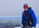
I arrived suddenly at the summit, emerging from the last few rock steps to a much more exciting view. The broad, nearly flat expense of the Fremont Glacier was visible below. The rock ended abruptly, with sheer cliffs and big exposure down to the glacier. The waves of peaks to the south and east emerged from behind the upper reaches of Fremont. The top of Gannett was visible to the north, and behind that the flatter, less rocky ridges/terrain on the north side of the range. 5 other people were on top, perched on some of the flat rocks next to the empty air on the north side. The mountains to the south and east were quickly swallowed by clouds and a light haze. Pinedale was visible to the south. Beyond Gannett, the northern peaks were also obscured by the clouds. The Tetons are probably visible on a clear day. 
It was probably 40 degrees with a steady wind and no sun on top, so I pulled out a heavier jacket to ward against the cold. I looked through the binoculars in all directions, sent some messages on the GPS, ate and admired the view. A sliver of Seneca Lake was visible way below, and the nearly flat terrain back to the car unfurled even farther away. I looked at the clock and realized the day was probably going to take longer than I expected. To the north, the distant sound of rushing water under the Fremont Glacier was audible. The other people left a few minutes before I did. I traversed to the west, toward a rock that looked like it might be slightly higher than the one I used as a seat. I tapped the top of it but the height difference was probably negligible. 


It took 30 minutes to descend back to the bottom of the ridge. The upper section wasn’t as tedious as I expected. I stayed to the west, off the angled slabs, and tried to step on the larger, more stable talus. There were a few sections of slick dirt but I was always able to find a more solid way down. I never heard any rocks fall down the slope. I steadily weaved my way down, angling back to the east once I was below the big slabs. I found my ascent route on the lower section and followed the cairns down. There were maybe 3 vertical steps, but these were under 4 feet and didn’t have any exposure. I passed 3 of the people from the summit and encountered another 4 people on their way up near the bottom of the ridge. The climbing on the upper mountain was fun- steep enough to break up the endless hiking on low-angle trails, but not loose or exposed enough to be dangerous. The unobstructed scenery to the south and west provided quite the backdrop too. 
I stopped at the bottom of the ridge to take off my long layers. The sky was getting steadily darker to the east and north. I descended the lower slope back to the Indian Basin trail in about 20 minutes. I thought about cutting south over the tundra and rock slabs, but decided against this. There was a possibility I’d end up on the mini cliffs above one of the lakes, or wallowing through some small moraine. I moved quickly through Indian Basin, passing the lakes as a few distant rolls of thunder sounded above Harrower Peak. I ran down the hill by the creek and emerged into the sun at the junction with the Titcomb Basin trail. There was more rain and thunder around Fremont- I wonder how the people who were still up there fared. 
I ate at the trail junction, then stopped yet again at the Island Lake creek to fill up water for the hike back to the car. I mostly hiked back to camp. Running was difficult on this trip. The trails were rocky, though I’m sure I’ve run on trails with just as many rocks and uneven surfaces elsewhere. My pack was heavy both days and the general fatigue from carrying in all the gear on Thursday, and sleeping in the tent for 2 nights, probably kept my legs from fully recovering. The terrain itself was also deceptive. Lots of false flats and really gradual climbs. For being in the high mountains, with glaciers and exposed summits, there really wasn’t much vertical gain on this trip. 
I ate and drank on the move, passing some people going both directions and catching a horse train at Little Seneca Lake. Another big, dark storm cloud was bearing down from the south. I heard the thunder and saw the rain over the next ridge as I arrived at camp. I still had many hours of movement and focus to go, but I was glad I got to the top today. I think this summit would be a reasonable 1-day run from the car. It’s slightly shorter, both horizontally and vertically, than any of the Chicago Basin summits starting at Purgatory, and the only climbing is on the upper 1500’ of the peak. 
Hike to the car Strava: https://www.strava.com/activities/15496622657 This was by far the most miserable death march back to the car I’ve ever done. I arrived back at camp moments before the rain started and dove into the tent before everything got soaked. I packed up everything except the tent itself as rain, then hail, pounded down. The sky was clear again about 30 minutes later. The rain fly was wet so I lashed it on the back of the pack, but everything else stayed dry. I loaded up both packs and started down the trail. I split 30 minute miles to Photographer’s Point. It was horribly slow but I couldn’t make my legs move any faster. The sky was still dark in all directions and with a light wind it was slightly cold. I didn’t put on any layers because I figured I’d get too hot with all the weight, and I didn’t want to take the 5 minutes to take off both packs and dig around for a jacket. The clouds eventually moved on and the sun was out for the final 2 hours to the car. I stopped to eat somewhere around Hobbs Lake and somehow felt marginally more inspired for the climb to Photographer’s Point. I stopped there to eat again, and took a final look at the Titcomb Basin summits. 
It took 90 minutes to hike 5 miles and 900’ downhill from Photographer’s Point to the car. I have rarely moved so slowly. My heart rate was around 110, which often happens when I reach ‘as slow as possible while still moving’ territory at the end of a long day. The sun continued to slide to the horizon. There was very little scenery in the forest and nothing to occupy my mind. I tried to break up the monotony by checking the watch, drinking and eating every 10-15 minutes, and every time I was amazed at how little I’d progressed. My main thought was the 4.5 hour drive, in the dark, that awaited when I got back to the car. I thought today would be shorter than yesterday, but that clearly wasn’t true. The final 1.5 miles were brutal. The last curve on the trail was the longest quarter mile I can ever remember traversing. I kept thinking of perhaps my favorite line from The Sopranos, uttered by Paulie as he and Christopher are lost in the snow in the 'Pine Barrens' episode: “I ain’t stopping until I hit cement.” The parking lot FINALLY emerged from the trees around 7 PM. I was 2 hours behind my anticipated schedule but finally off the trail. Drive to Casper I threw the packs down on the ground at the car, completely exhausted and very ready to get the hell back to civilization. The mosquitoes were swarming so I threw everything in the back, put on clean clothes, sent a few messages on the GPS and drove down to Pinedale. I got gas and 2 sodas, organized the gear/clothes/food in the car, checked in on the phone and resolved to get home. The last light faded from the sky as I left town. Another dark, dense cloud of rain quickly swept over the central Winds. Fremont Peak was completely covered. I chugged 1 soda before Farson, then sipped on the other one to Muddy Gap. I was very alert for the whole drive home. There was nobody behind me from Pinedale all the way to Jeffrey City, though the other direction had fairly steady traffic. I saw 4 deer total next to the road, grazing and unaware of the traffic. The moon rose as I reached Muddy Gap. I got home at 1 AM. My next summit in the Winds should be Wind River Peak from the Lander side. That’s about 30 miles and a vertical mile of climbing, and it’s more accessible than the central mountains in the Titcomb region. Gannett Peak and the other big summits will have to wait. A longer trip, probably with someone to rope up with for the glacier crossings, will be necessary for those. Gannett is too far and too involved to attempt in a single day, I think. The rocky terrain and Bonney Pass climb on the south side would make travel slow, especially on the approach, which would be mostly/entirely in the dark. The north side doesn't have Bonney Pass, but the mileage from the car is even longer. The Tourist Creek route on the northwest side doesn't require any glacier crossings, but it has many miles of brutal off-trail talus thrashing. The mighty Anton Krupicka thinks that route is tough, so for us mortals it's surely a huge undertaking. Even with perfect snow/glacier conditions, perfect weather and excellent fitness, a 'day' trip of Gannett is probably still 30+ hours. I'll leave that for Kilian. I should also figure out how to pack better for multi-overnight camping trips. I'm fast enough on the trail that I usually climb/run routes in a single day. It's just easier to start early and cover 30-40 miles in 1 day than it is to haul camping gear and multiple days of food. But, these bigger and more remote mountains will require more camping and optimization of gear/weight. I also went up to the Big Horn Range while I was in Wyoming and attempted to run Cloud Peak, a 13er and the highest summit in the range. I got rained out well below the peak. I have no inclination right now to try all the Wyoming 13ers, but some are easier than others and merit an attempt at some point. Others require climbing skill I don't have, or are too risky. Francs Peak is like a Sawatch walk-up but has so many grizzly bears that the prevailing advice is to go up armed like a Navy SEAL! Hopefully I can return to the Winds for Wind River Peak and a few long runs in the next few years. Thumbnails for uploaded photos (click to open slideshow): ")
")
")
")
")
")
")
")
")
")
")
")
")
")
")
")
")
")
")
")
")
")
")
")
")
")
")
")
|
| Comments or Questions | ||||||
|---|---|---|---|---|---|---|
|
Caution: The information contained in this report may not be accurate and should not be the only resource used in preparation for your climb. Failure to have the necessary experience, physical conditioning, supplies or equipment can result in injury or death. 14ers.com and the author(s) of this report provide no warranties, either express or implied, that the information provided is accurate or reliable. By using the information provided, you agree to indemnify and hold harmless 14ers.com and the report author(s) with respect to any claims and demands against them, including any attorney fees and expenses. Please read the 14ers.com Safety and Disclaimer pages for more information.
Please respect private property: 14ers.com supports the rights of private landowners to determine how and by whom their land will be used. In Colorado, it is your responsibility to determine if land is private and to obtain the appropriate permission before entering the property.