| Report Type | Full |
| Peak(s) |
Wilson Peak - 14,021 feet |
| Date Posted | 06/24/2025 |
| Modified | 06/25/2025 |
| Date Climbed | 06/24/2025 |
| Author | masonzastrow |
| Exploring The Bilky Way Galaxy |
|---|
|
Exploring the Bilky Way Galaxy
(As an important disclaimer, I had one song in my head for almost the entirety of both of these hikes. So if you're imagining me hiking, please also imagine me singing and whistling "Guitar Man" by Bread) (Or the cover by CAKE if you prefer) The Idea A few months ago, I was looking over my remaining 14ers and realized that I might have trouble getting to Wilson Peak. For all its upside, my Nissan Juke would not be making it to the Rock of Ages Trailhead. And since I was more interested in approaching El Diente and Mount Wilson from the south, a backpack into Navajo Basin didn't save any time or effort. I was also interested in climbing Gladstone, and noticed that a significant portion of the spicy ridge-proper return trip could be skipped if you were able to descend down into the basin early, which looks seriously unpleasant if you're descending into Navajo (good on those who have) but pretty easy if you're descending into Bilk. Originally I planned on getting to the upper basin via Cross Mountain trailhead, which added some distance and vert, but was easily accessible by any car whatsoever. The other option, the Sunshine Mesa trailhead, is shorter, less gain, and a 2/6 on the 14ers difficulty ranking, which typically thwarts the Juke. I decided I'd give Sunshine Mesa a shot, with extra time allowed to head the extra miles if I had to resort to Cross Mountain. Trip 1: 6/21/25-6/22/25 The Trailhead Test The road to the Sunshine Mesa trailhead ended up being mostly an afterthought, I kept waiting for it to get worse and it never did! It definitely isn't paved, there are some real ruts, mud spots, and decent sized rocks. That said, anything bigger than a sedan can probably get there. I will say, it is a narrow road. Passing would be extremely difficult from the point where the road stops going straight south. At .7 miles before the trailhead, I encountered into a huge downed aspen. Obviously, I took out my trusty handsaw and tried cutting an eighteen inch trunk with my eight inch blade. After making it through the bark, I decided it was totally useless and did my first ever eleven point turn to get my car down to the nearest pull off. I checked On X, and moved down one more pull off to park on public land. There is very little parking on the road and I was lucky this spot was available, there really aren't alternatives.
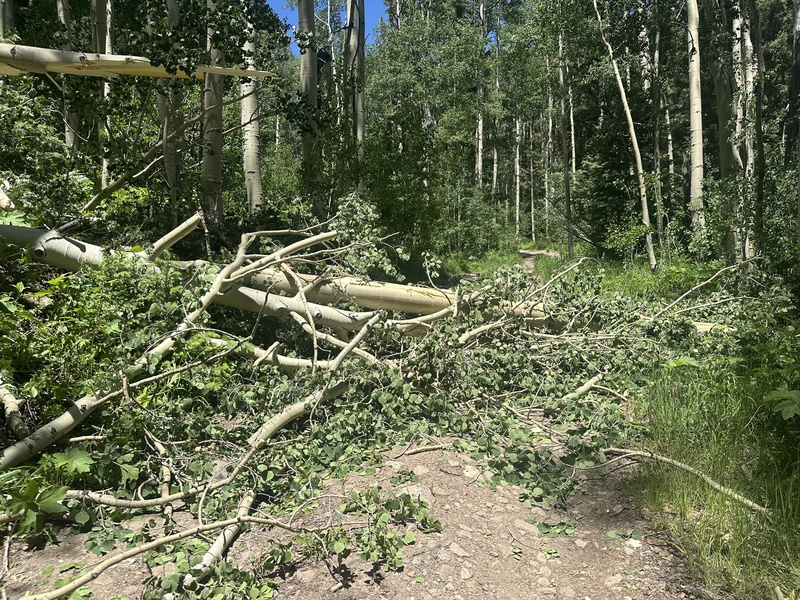
Getting to the Lake My goal for Saturday was just to get up to the lake at 12,000 feet. I'd camp up there, get an early start, and go for Gladstone as long as winds weren't too bad. They were forecasted to be blowing almost straight north at 35mph, which did not bode well for Gladstone, but I figured they'd follow the typical summer pattern of not getting really aggressive until somewhere in the 8-10 range, which would give me plenty of time to get Wilson and then make a weather call. After hiking the remainder of the road and starting on the trail, I was confronted with a ridiculous number of downed trees. Now, I am no trail snob. I love taking non-standard routes, and I recognize that means some bushwhacking. But on an established trail, I have never had such trouble moving past downed trees.
(imagine one of these every 400 feet or so, for 1.5 miles) With my 70 liter pack, it was difficult to get around these. But after breaking some branches, I made it to the next challenge: the creek crossing. Previous reports from Bilk Basin have indicated that this is a tricky crossing, and I figured that coming in June was doing myself no favors. This is why I brought along my handsaw. I really don't know what I was expecting to do with it. Maybe create a beautiful dovetail jointed work of architecture that would be revered not only as a utility to the trail, but also as a standalone piece of art, drawing tourists from every corner of the nation to admire the craftsmanship. Maybe there would be one perfectly sized teetering dead tree which only require a couple of scratches to topple, and then I confidently lead a troupe of forest creatures over their new superhighway. Neither of these scenarios happened. The creek is too wide and I just took my boots off.
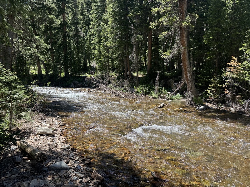
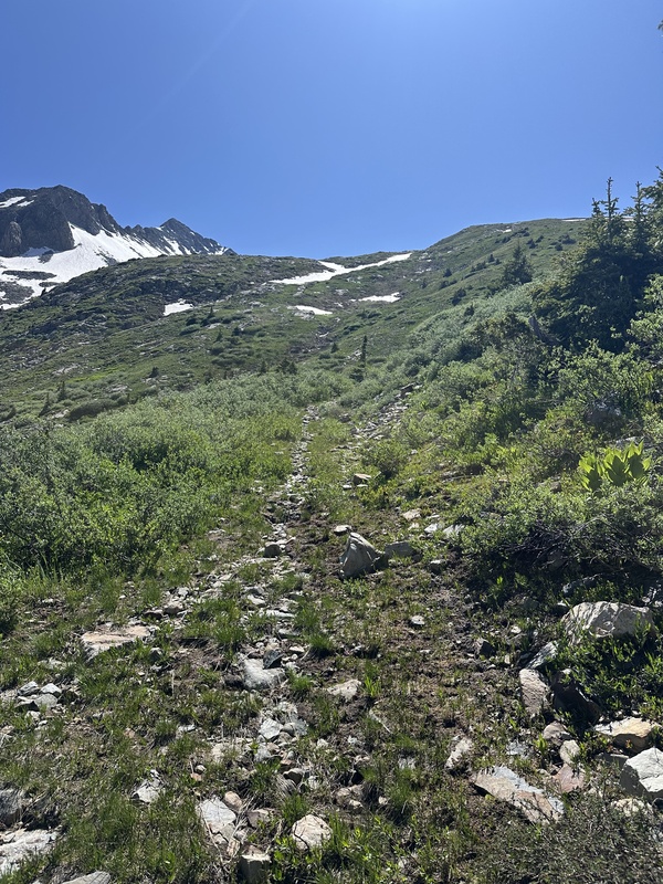
You'll really feel the current as you cross, but with poles, it isn't much trouble. My one warning is that it's really easy to miss on the way back. If you see this sign, you've gone too far! After the creek crossing, you'll head south for a bit before switchbacking up 700 feet, compensating for a period where Bilk Creek has some spectacular waterfalls.
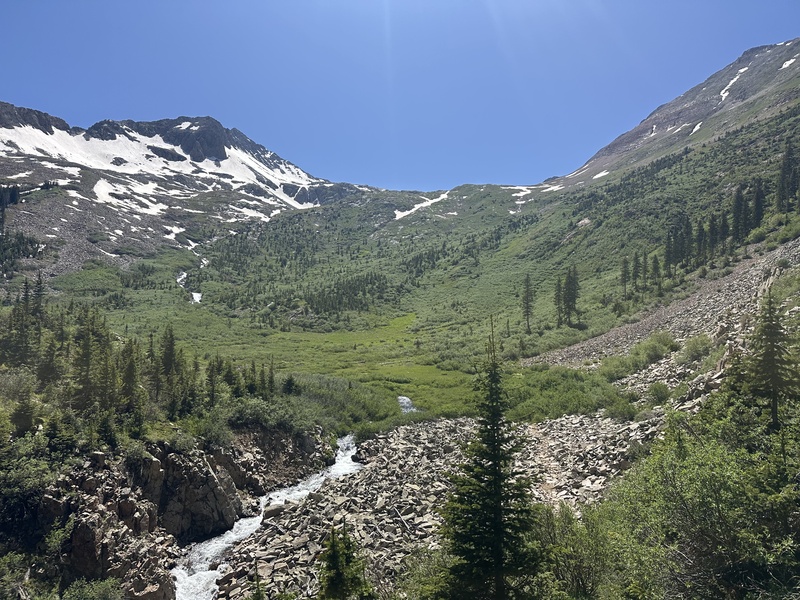
There are more falls that photos don't do any justice. At this time of year, the higher waterfalls are something you feel just as much as you see. You'll have to go experience them yourself. After the switchbacks, you get your last stretch with tree cover for this route. Then you enter a... healthy... bramble of willows. I didn't get any photos here because I was mostly holding my hands above my head. It's not as muddy as the descent from Sawtooth Ridge, but it's about as thick. I lost the path at one point and completely missed a switchback, which I didn't even notice because for plenty of the time, it doesn't feel like there's a trail through these. Eventually, you'll come to the point where the trail begins to climb into the upper basin on an old mining road. Right before the road begins, you'll meet the northern terminus of the Cross Mountain section of the Bilk Basin trail. In June, coming from that side will cause you real trouble. From my viewpoint, this crossing is entirely unsafe right now. I think you'd have to go straight up the mountain and cross up by the lake to avoid the rapids this stream has.
The Bilky Way!
Creek "crossing", if you're coming from Cross Mountain TH. The gap between the two big rocks is probably 3-4 feet.
The old road Camping at 12,000 feet in 25 mph winds Everyone has to learn their lesson at some point, here's where I learned mine. This really doesn't work. The forecasted winds overnight were 25mph going north, so I set up my tent with a wall to the south.
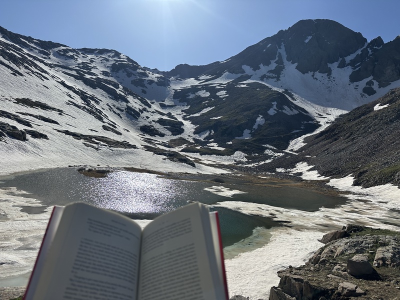
There were a ton of marmots up here, and they were VERY interested that they had a new friend. They'd come within a few feet of me to check me out. After I set up, I got out my book and read for a couple of hours.
Sidebar: My Book I'm currently reading "Crying in H-Mart" by Michelle Zauner, AKA the Indie-Rock artist Japanese Breakfast. My friend Molly leant me the book for my summer in Montrose, and with 50 pages left, it's a favorite. The story is Zauner's memoir, chronicling the period where her mother is diagnosed with cancer. It goes through how her relationship with her mother has evolved over her life, her initial reaction to her diagnosis, how her complicated family handled treatment, and her mother's eventual death (I promise this is not a spoiler). It is equal parts painful and beautiful, and I was grateful that there was nobody but the marmots to see me ugly cry. Back to the story The experienced, the learned, and actually anyone with common sense on this site can tell you how this story ends. After the sun set behind the ridge, the winds picked up and started ripping my tent stakes out of the ground. The northern winds curved around my southward shelter and hammered the lake coming straight from the east. After hunkering down in my $26 tent off Temu for about 45 minutes (this is the same model, for those interested), I decided there was no way I could sleep with the flapping and the constant re-staking of the tent. And even if I slept up here, it was hard to believe it'd be safe to climb class 3 the next day in winds even stronger than these. Some trips don't work out. A little after 8, I recalled a great camping spot down by the river and packed up everything. I arrived around 10 and rebuilt up my tent by the light of my headlamp. I'm thankful this happened to be on the solstice, giving me as much sunlight as possible to rectify my mistake.
Hard to believe this is after 8! Sunset on Sunshine. The next morning, I decided to enjoy my peak-free camping trip, sleeping in until 8 and reading for a couple more hours. On my way out, I used my free time and my hand saw to chop branches off those downed trees to make traversing over them a little less of a hassle. I figure there's no glory in keeping dead trees on the trail. Little did I know, I'd be doing myself a favor just two days from then! Trip 2: 6/24/25 So why was I so quick to return? Well, I was planning on climbing the Bells on the 24th and 25th, but sometimes trips just aren't meant to be. My climbing partner for the bells got stranded in Frisco with car trouble, preventing him from joining me. Shortly after I got that news, I was told that I had an unexpected work obligation that meant I needed to be in Gunnison on the 25th for most of the day. But my Tuesday was still free! With Wilson Peak being my only remaining 14er that I can easily day trip living in Montrose, I decided that I might as well head back over Dallas Divide. Changing Strategy I decided that this time I would take a different approach. Instead of camping up in the basin, I would move fast and light. Given my previous pace to the lake, A 3 AM start should allow me to hit the saddle somewhere in the 6-7 window, which would mean I'd have a good chance at having the time to go for Gladstone as well. I'd go light and fast: trail runners instead of boots, micro spikes instead of crampons, and about 10 lbs less of camping gear. Your Plan Will Never Go How You Want It To And That's Okay Obviously, Mother Nature had other ideas. I drove back to my single parking space on the road without incident, and hiked to see if the tree had been cleared. It had! I messaged San Miguel County about the tree Monday morning, so good on them for getting it so quick! Or if it was just a good samaritan, thank you as well. I was ready to sleep in my car when I realized that I did not bring a sleeping bag. Luckily, I had a blanket in my car! Unluckily, it was filled with cactus needles from a stint of reading on some BLM land where I was a little careless where I lied down. I folded it just so that the quills were underneath layers and used it as a pillow, and took my coat out of my backpack to put on my legs. This was good enough for about six hours of sleep, which is all you can ask for with these early starts. I had boots on the trail at 3:15 after slamming a pop-tart. And at about 3:30, I had rain on my head too. What? The forecast said it would be clear until about 9, then a slight chance of showers. Such is life. I kept hiking. It drizzled on and off for the first two hours of the hike, and I was starting to get worried that I'd be too wet to comfortably climb above 12,000. Although I wasn't facing the 35 mph winds of Sunday morning, I was still facing about 20mph and from the rate clouds were moving, I could tell it might be even higher. The dense willows left me with no option to stay dry, my shorts, leggings, and jacket were waterlogged. I decided that I needed to dry out before going higher. It is what it is. At about 11'900, I got my first glimpse of direct sunlight and took off everything but my base layers to lay out. After about 30 minutes, I felt good enough to keep going. Above the lake, navigation was more difficult. On the way up, I mostly stayed on snow, with micro-spikes on my trail runners and my axe in my hand. This worked pretty well, but my feet got soaked doing so. I decided to keep my one change of socks for when I met with the standard route to give myself the best opportunity to have feeling in my toes for the last 800 feet of gain. I made it to the saddle and left my soggy socks there, with the ankles under a rock so they wouldn't blow away.
The options climbing from 12,100 at the lake to 13,200 at the point where Bilk Basin intersects the standard route. I briefly found a trail here, but it only was above snow for a couple hundred horizontal feet. This is mostly freestyle.
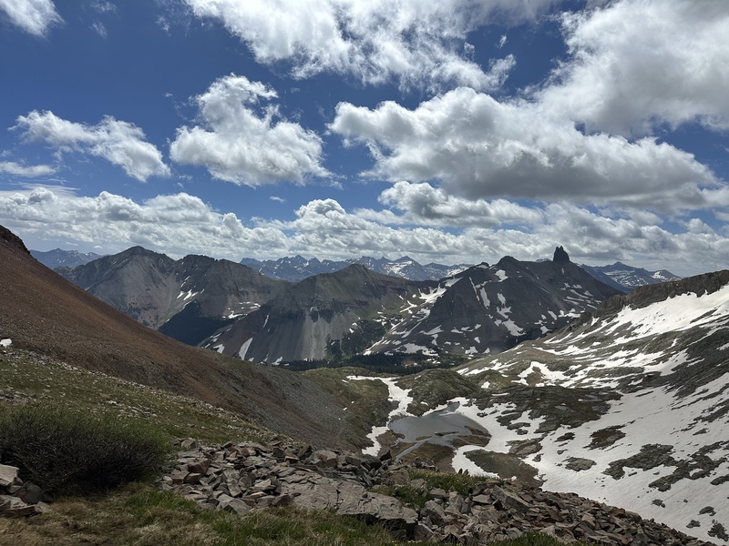
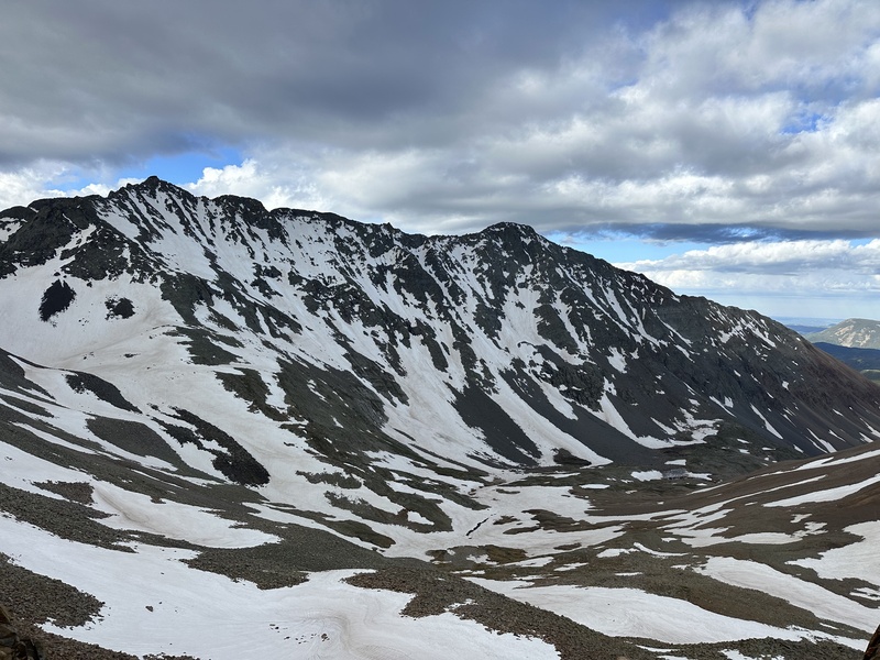
At the saddle, viewing Navajo Lake, Mount Wilson, and El Diente I was pleasantly surprised at how dry the ridge was and how fun the climbing was. I have heard other climbers talk about the Wilson group as this choss pile that had the misfortune of making the 14,000 foot list. Frequently using four letter words. Or 13 letter words, if you're Virtual Sherpa. I actually found the rock to be generally stable, both on the talus fields above the lake and on the stretch above 13,200. I thought the climbing in the notch was a blast, with fun angle-y moves that were creative but never scary.
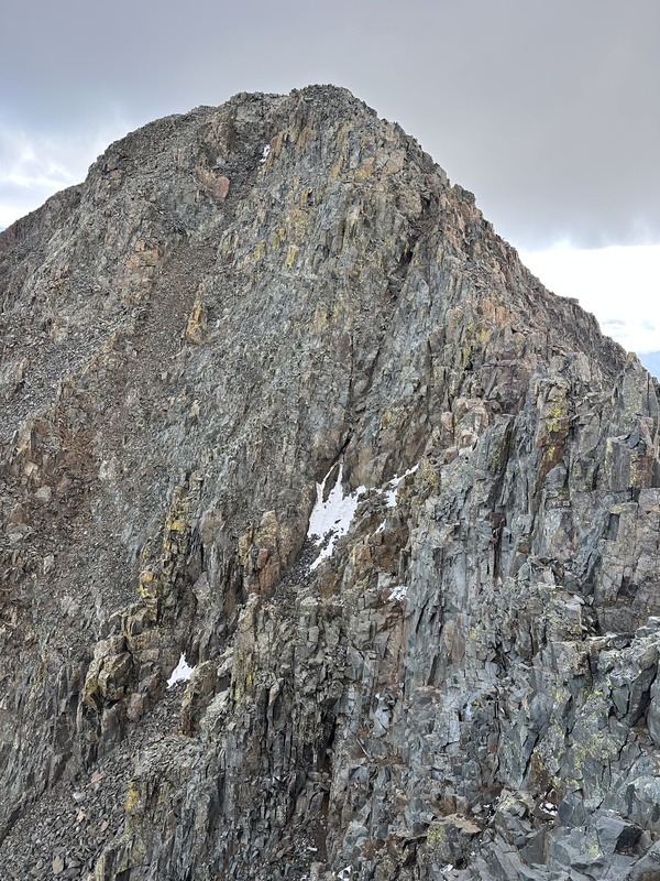
From the false summit
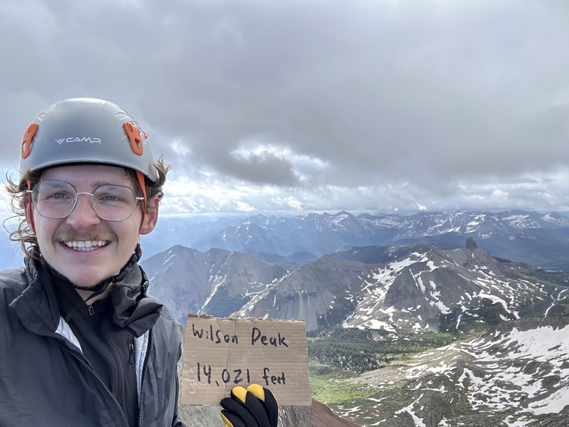
Success! 9 more to go! All in all, this summit was fantastic. There was only one blemish on the day...
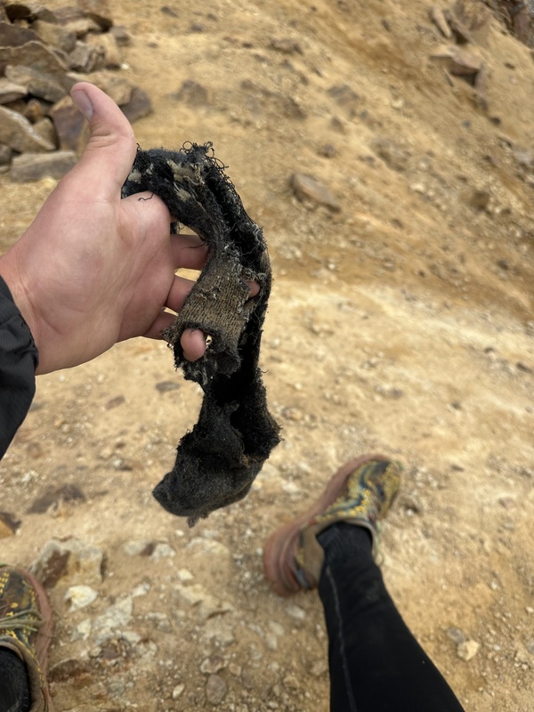
It never even crossed my mind that the very same marmots who had kept me company two days before might betray me like this. I wonder how generous that Darn Tough warranty is... I decided against going for Gladstone. It took longer than I expected to get to the standard route from the lake, which combined with my 30 minute drying out break meant that I'd be really pushed for time. And Gladstone is certainly not a peak I'm looking to be rushed on. I have no complaints returning to Bilk Basin, it is one of the prettier places I have been in Colorado. I'll welcome the excuse to come back.
The return to the car was uneventful, aside from one completely unexplainable moment where I hit dirt. These Merrils are amazing shoes for scrambling but I am guaranteed to trip or roll an ankle about three times a hike in them. On my way back to Montrose, I stopped at Sawpit Mercantile for a bite and enjoyed an Elk Brat titled "The Wilson". I figured I earned it. And I bought one more special treat there as well...
Hey, I climbed that! Total time: 10:25 car to car Total distance: 14.4 miles Total gain: 4,600 feet Thumbnails for uploaded photos (click to open slideshow):  There are one million streams of this size crossing the trail")
 Wildflowers coming out!")
 There are some beautiful water features along this trail")
 If you see this sign, you missed the creek crossing!")
 Hey I climbed that!")
 Clouds were really moving along today")
")
")
 Rest in peace, Bilk Basin Cabin")
")
")
 Sunrise was lovely")
")
")
")
 There are a lot of these")
")
")
 The crossing required to go from Cross Mountain trailhead to connect to the upper Bilk Basin trail")
")
 Well, it was nice for a while")
 Sunshine Mountain is well named")
|
| Comments or Questions | |||
|---|---|---|---|
|
Caution: The information contained in this report may not be accurate and should not be the only resource used in preparation for your climb. Failure to have the necessary experience, physical conditioning, supplies or equipment can result in injury or death. 14ers.com and the author(s) of this report provide no warranties, either express or implied, that the information provided is accurate or reliable. By using the information provided, you agree to indemnify and hold harmless 14ers.com and the report author(s) with respect to any claims and demands against them, including any attorney fees and expenses. Please read the 14ers.com Safety and Disclaimer pages for more information.
Please respect private property: 14ers.com supports the rights of private landowners to determine how and by whom their land will be used. In Colorado, it is your responsibility to determine if land is private and to obtain the appropriate permission before entering the property.