Download Agreement, Release, and Acknowledgement of Risk:
You (the person requesting this file download) fully understand mountain climbing ("Activity") involves risks and dangers of serious bodily injury, including permanent disability, paralysis, and death ("Risks") and you fully accept and assume all such risks and all responsibility for losses, costs, and damages you incur as a result of your participation in this Activity.
You acknowledge that information in the file you have chosen to download may not be accurate and may contain errors. You agree to assume all risks when using this information and agree to release and discharge 14ers.com, 14ers Inc. and the author(s) of such information (collectively, the "Released Parties").
You hereby discharge the Released Parties from all damages, actions, claims and liabilities of any nature, specifically including, but not limited to, damages, actions, claims and liabilities arising from or related to the negligence of the Released Parties. You further agree to indemnify, hold harmless and defend 14ers.com, 14ers Inc. and each of the other Released Parties from and against any loss, damage, liability and expense, including costs and attorney fees, incurred by 14ers.com, 14ers Inc. or any of the other Released Parties as a result of you using information provided on the 14ers.com or 14ers Inc. websites.
You have read this agreement, fully understand its terms and intend it to be a complete and unconditional release of all liability to the greatest extent allowed by law and agree that if any portion of this agreement is held to be invalid the balance, notwithstanding, shall continue in full force and effect.
By clicking "OK" you agree to these terms. If you DO NOT agree, click "Cancel"...
Abrams Mountain [LoJ], North Face, Mod. Snow AI2-3
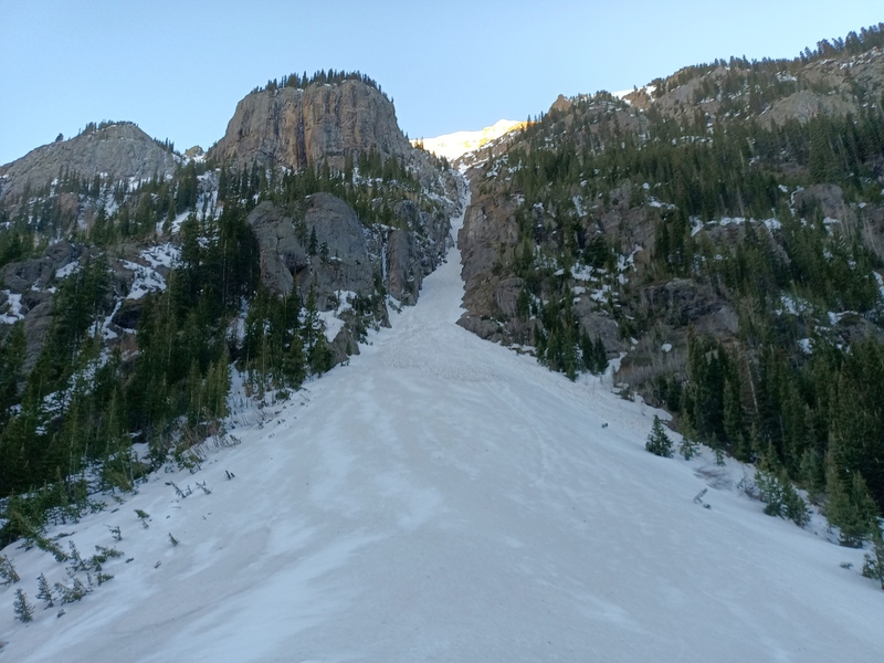
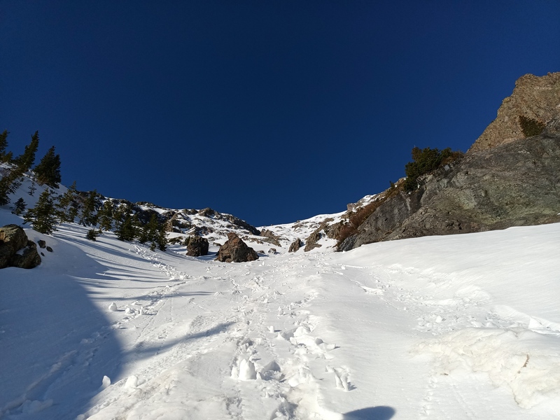
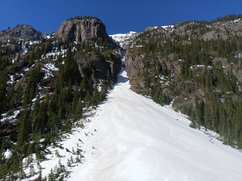
This is another itch I've been wanting to scratch for years; always, it seemed, several weeks too late for conditions in the inset lower couloir, which harbors a short drop that tends to be a waterfall by early June. The line starts immediately off the Engineer Pass road (CR 18 south of Ouray, as for Poughkeepsie Gulch and Mineral Creek)--often avalanches run full track down it and cover the road into spring--and goes for 2,900 feet directly to the summit, making a rare prize of firm snow from the starting elevation at 9,900' all the way up.
Recent experience on aspects with sun exposure was positive, so despite a system bringing a few inches of new snow to the range, we decided to go after the first clear night. Arriving on target at 6am, we could see ice on the drop--a good sign. We parked right at the base of the couloir and walked 10 feet to gear up on the apron, then started cramponing up the galley. The snow had an excellent hard-freeze crust on the latest avalanche interface and we made quick work of the first 1,000 feet approaching the ice step.
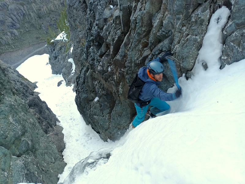
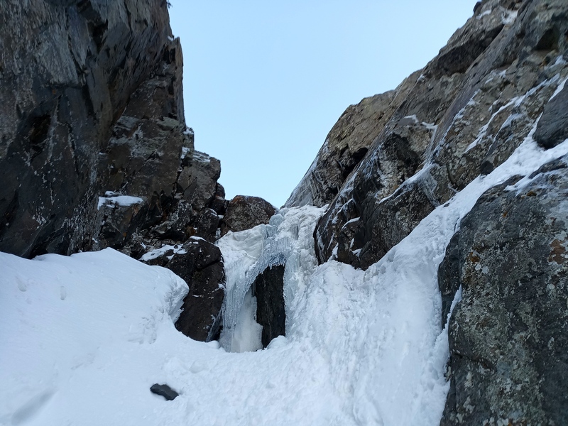
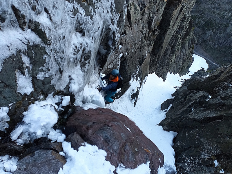
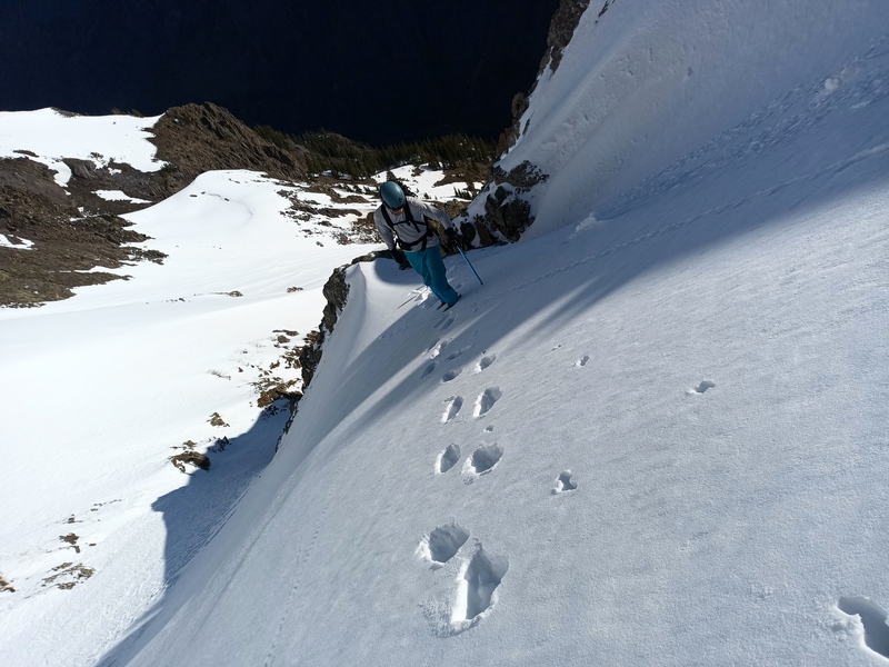
There we found a 20-foot cliff capped by a chockstone, with a standard alpine mess of delaminated ice and water running behind a lens down the center into a rocky moat. The only reasonable line was right of the flow, traversing back into the watercourse at the top. It was mostly unprotectable, and we hadn't brought gear anyway.
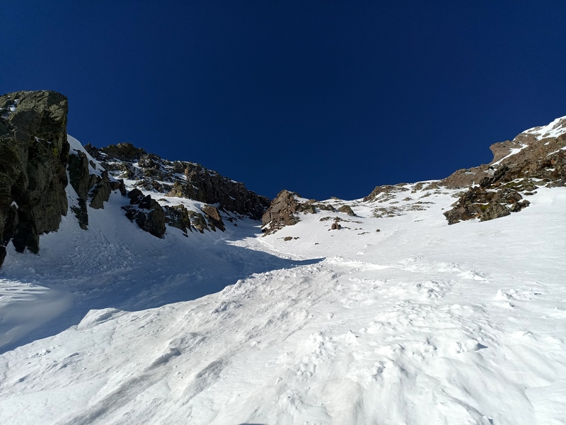
After that fairly gripping sequence, the couloir opens up to the face, and early sun. The snow became more variable, but still good as we passed through piles of snice balls from the previous day's localized avalanches in the new snow. Just over 900 feet led to a shallow fork where we trended left into the well-defined, shaded upper couloir.
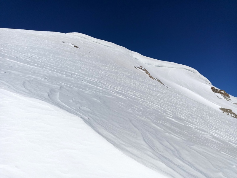
Here snow conditions became unsurprisingly blue-collar for the better part of 500 feet before the couloir opened again to the sunny slopes of the upper face. We strayed a bit left and could have met the east ridge shortly on that trajectory, but the snow on the face was supportive and the proper apex of the climb, found another 500 feet up at the left edge of a relatively mild cornice wall (this year), was directly off the summit.
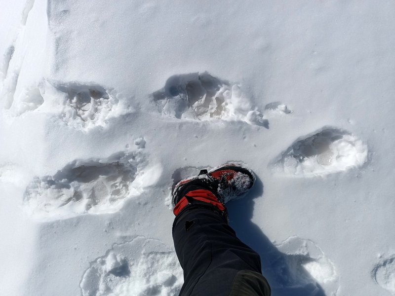
We descended the south ridge to the first obvious saddle at 12,500', which had been recently used by a snow-climbing fool of a bear, and glissaded most of the 2,200 feet down to the Poughkeepsie Gulch road for a largely snow-free hike back to the truck.
Route notes: Snow steepness is mostly 40 deg. or less with a few steeper rolls. Difficulty of the ice step could vary from AI2 to wet M-awful. Though we didn't have an issue with the early start, any rock or other debris falling down the face funnels into the lower third of the route. Look for this one mid to late May.
Road notes: CR 18 is rough and sucks even more in the spring. Bring a 4WD with decent clearance, and there's an obstacle just before the couloir that your vehicle may not enjoy. Parking just below this doesn't really incur an approach penalty.
Starting up
Dylan on lower steepness
Ice step
Dylan up ice. Overview of parking below.
Above the ice
Upper couloir
On the upper face
Summit
Bear
Parting shot from the truck
My GPS Tracks on Google Maps (made from a .GPX file upload):
If you get hit with falling ice, it's your own fault and based on the ice fall path seen here on Abrams Mountain should multiple parties get in the mix how would you rate the situation based on the petition from the unauthorized climbing boss bitch who normalizes sharing beta?
From the totally unofficial icefall awareness coordinator this climb can fall into one of 4 categories:
--If icefall nukes the whole climb, get up before everyone else and sprint ahead or bail if already occupied.
--If icefall is predicted to stay in place, a latte start is the norm. Line up in queue.
--If icefall will drop bombs, wear NFL shoulder pads, helmet and mouth guard for the predicted chaos.
--If you have no idea what's going to happen just make sure your CORSA, WFR and SAR are up to date.
Now I'm not telling anyone what to do. I'm just here holding this clipboard, wearing this imaginary badge, and waiving this petition sign, totally not issuing commandments. This is not a trick question this time, which category does your climb fit into so I can tally the data and report to Boss Bitch who strongly recommends you not die under someone else's ice chunks.
Haaaaa! Having seen the top of the face from the highway 20 miles away I can say with certainty that it supports multiple parties juuuuuuust fine.
Latte start sounds like the right program.
Caution: The information contained in this report may not be accurate and should not be the only resource used in preparation for your climb. Failure to have the necessary experience, physical conditioning, supplies or equipment can result in injury or death. 14ers.com and the author(s) of this report provide no warranties, either express or implied, that the information provided is accurate or reliable. By using the information provided, you agree to indemnify and hold harmless 14ers.com and the report author(s) with respect to any claims and demands against them, including any attorney fees and expenses. Please read the 14ers.com Safety and Disclaimer pages for more information.
Please respect private property: 14ers.com supports the rights of private landowners to determine how and by whom their land will be used. In Colorado, it is your responsibility to determine if land is private and to obtain the appropriate permission before entering the property.
 Starting up")
 Dylan on lower steepness")
 Ice step")
 Dylan up ice. Overview of parking below.")
 Above the ice")
 Upper couloir")
 On the upper face")
 Summit")
 Bear")
 Parting shot from the truck")


