| Report Type | Full |
| Peak(s) |
Capitol Peak - 14,138 feet |
| Date Posted | 05/02/2026 |
| Date Climbed | 07/10/2024 |
| Author | drewharrellrtr |
| Capitol Peak |
|---|
|
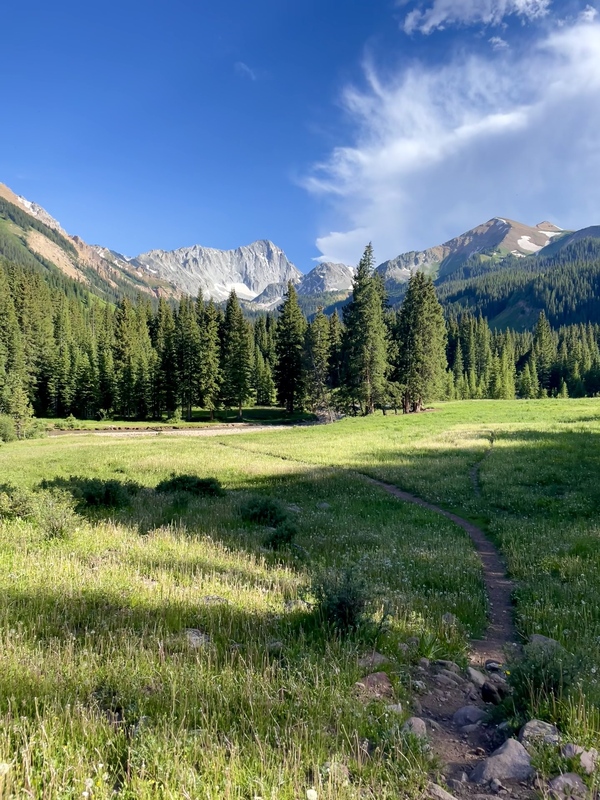
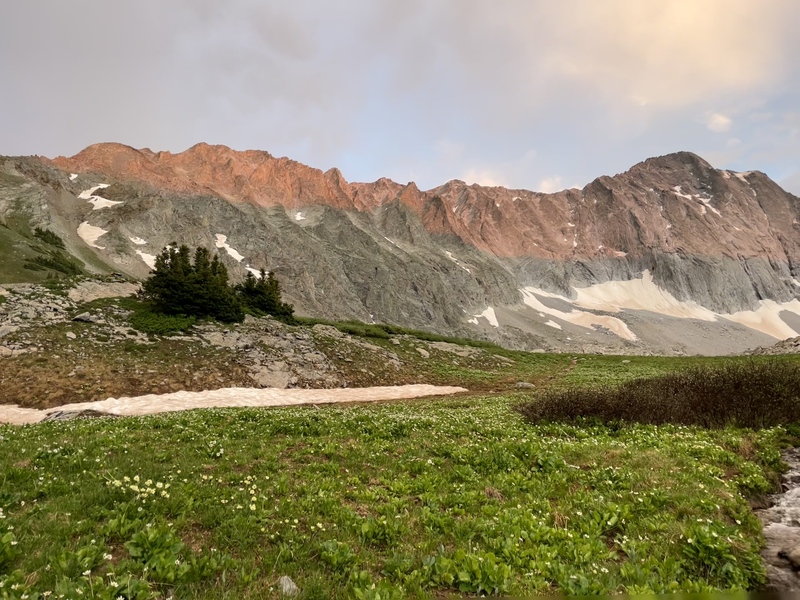
Intro The trip for this report is now almost 2 years ago from posting this. It is something I wanted to write about for awhile, put off for awhile, worked on sporadically from time to time, put off for even longer, and have finally got around to proof reading it and posting it. This story is about my dad and I's summit of Capitol Peak, learning to prepare for literally anything in the future, and gratitude in a God that works things out for His glory. I hope you enjoy! Background In the afternoon of July 9th, 2024, my dad and I set out to climb Capitol Peak. We have a goal to summit all 58 of Colorado's 14ers, and if we're being honest, we never originally thought we would be able to fully accomplish that when we first set out hiking Colorado's 14ers. And that was valid, given that we are Texans that are blessed to get to spend a couple weeks every summer soaking up the beauty of God's creation in the mountains of Colorado. So, let's first recap how we got here. My dad began his journey with his dad before I was born. He has told me of how they had Gerry Roach's book and started with some of the easier ones, not giving any realistic thought to the challenges of class 3 and higher. Then I came along. I spent many summers in the shadow of Long's Peak (the only class 3 peak my dad had done to that point in time), and having looked up at it for years, I finally got 14er fever. Unfortunately, my first attempt stalled out in the Trough of Long's Peak, about half a mile from the summit. I was 13 years old at the time, in the summer of 2011. My next attempt at a 14er came on Mt. Sneffels where I was turned around by some snow in the Lavender Couloir, about a quarter mile from the summit. My first 14er summit finally came in the summer of 2013 on Quandary Peak (I finally attempted a more beginner friendly peak). There was a mountain goat family with a baby waiting to greet me at the top! How much better can it get!? And so I was hooked, and I wanted more. I got Long's Peak the next summer. My family began exploring other areas of Colorado besides Estes Park, which led to time spent in Ouray and the San Juan mountains. I got to tackle a few more easier 14ers, which included Handies Peak on July 11, 2015. That was a day I will never forget, as we got snowed on while regaining the pass on the approach from the Silverton side. Fast forward a little more and I had some more class 2-3 peaks with the Sawtooth Ridge and Mt. Sneffels via the SW Ridge. The last peak in the Lake City area that we could access at the time was Wetterhorn Peak (Nellie Creek was too rough for any vehicle we had at the time). We had some class 3 experience, but none of that seemed to compare to the steepness and exposure of the Wetterhorn summit pitch. To prevent this background info from running too long, we made the summit quite easily. My dad would later tell me that he fully expected us to turn around at the summit pitch that day and only went because I was determined to at least try it. This marked the turning point in our journey, the moment where we began to realize we might actually be able to do them all. We began checking more and more peaks off the list with increasing difficulty, working up to the Crestones, Wilson Peak, Kit Carson & Challenger, Lindsey, El Diente and Mt Wilson (our 1st great traverse), Pyramid, and then the Bells Traverse (our 2nd great traverse). But there was still Capitol Peak out there... Capitol Peak Even with the class 4 and 5 experience, the difficulty and reputation of Capitol Peak still loomed large. This wasn't a sure thing we were setting out to do. It is all too easy to just assume everything is going to work out and go to plan. The plan was to pack in Tuesday afternoon and camp at Capitol Lake, summit on Wednesday, and pack out that same day. We got a little bit of a late start, around 4:45pm. Delay number one was getting halfway to the trailhead from the campground at Reudi Reservoir and getting a call from mom informing us that we forgot to pack the tent poles. Oops! We definitely need those. So we turned around met about halfway with the family to pick those up. Delay number two was getting about 5-10 minutes into the hike and realizing we left the tent poles in the backseat of the car where they got put when we picked them up after forgetting them the first time. Off to a great start here! So, I ran back to the car to grab them. Now we're ready to go! We took the Upper Capitol Creek trail, commonly known as the "Ditch" trail. This is currently my favorite approach of any peak I have done to date. The view you get of the peak from the trailhead and almost the entire hike in is so unique and ominously displays the rugged grandeur of the ridge route to Capitol's summit. 


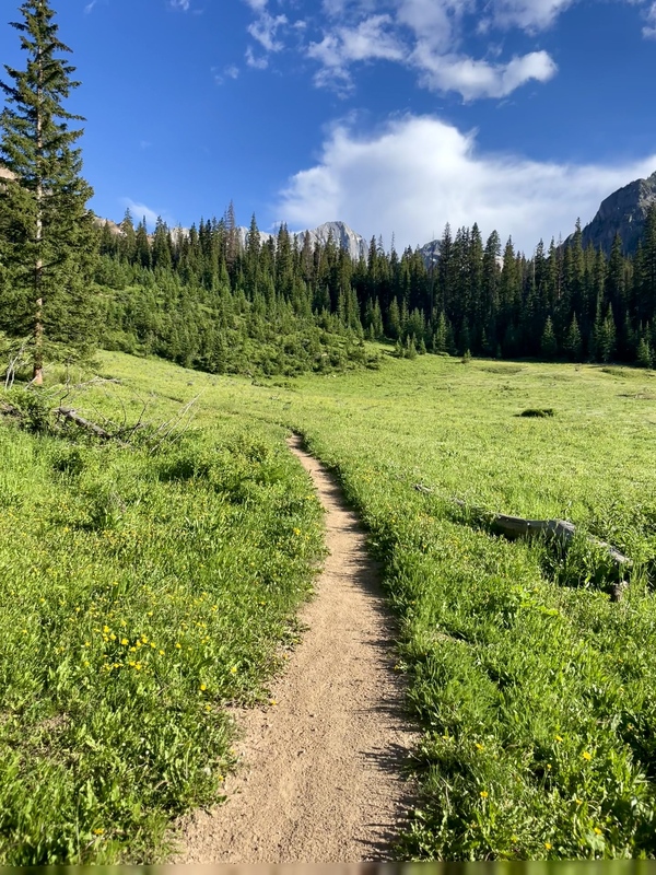
The hike in wasn't all that bad. Unlike most 14er routes, the first half is relatively flat, as promised in the route description. This is very convenient given that all the gear being packed in for camping is much heavier than a typical daypack. 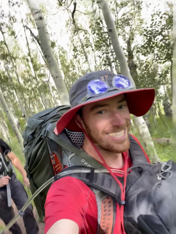
This was a tough crossing if the goal is to keep your shoes on and stay dry. There was one log to walk across that was not stable. We managed to cross without taking off shoes by using a long stick for balance. From this point on it is all uphill to the lake. After making really good time early in the flat sections, we lost pace a little bit and ended up taking around 3 hours to reach the lake and barely beating sunset. 
By this time it was almost 8pm, the sun was going down, and a light rain shower was blowing through. We raced to set up camp, and got started filtering water into the daypacks for the summit push the next morning. We also got a pot of water heating on the stove for dinner. 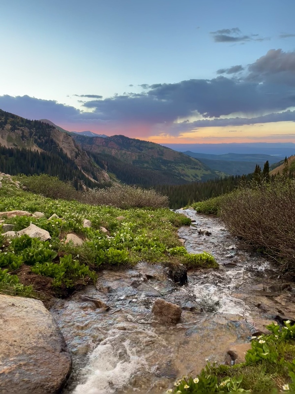
With the sun now gone, the temperature quickly plummeted. We quickly ate dinner, got settled into the tent a little before 10pm, and set an early 3:30 am alarm with the plan to reach the Daly saddle by sunrise. 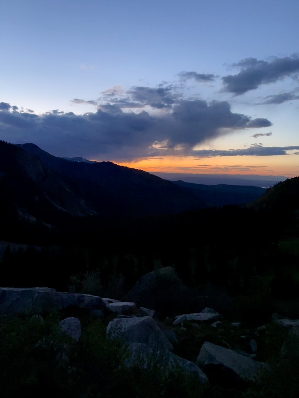
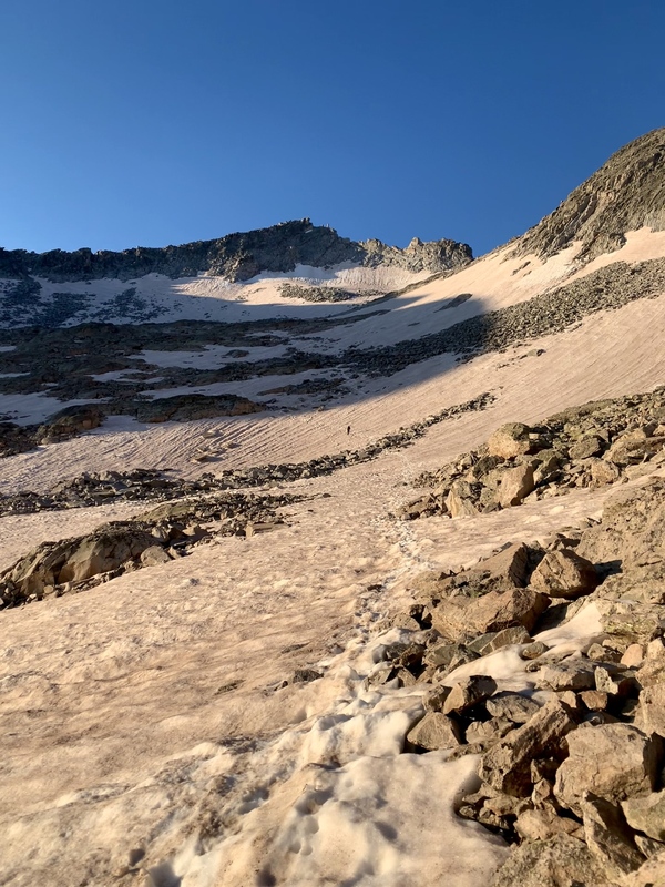
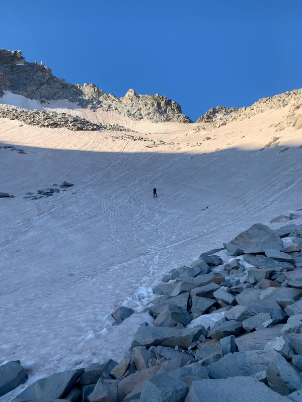
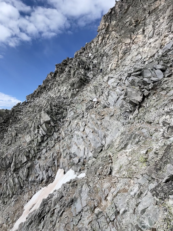
The alarm came super quick. We got up, got ready, and got moving on the trail around 4:45 am knowing we had a long day ahead of us. It is about 2.5 miles to the summit from the lake. However, this isn't just any 2.5 miles. These would be very slow going. There is a clear and obvious trail up to the Daly-K2 saddle. After that however, not so much. We made the Daly-K2 saddle just before the sun broke the horizon (5:25 am) and met a group of 3 hikers. They were headed ridge direct to K2. This route was appealing as it avoided dipping down the valley beneath the ridge and cut distance down by heading straight for K2. In hindsight, we probably would have joined them, but we didn't know anything about that route and hadn't studied it, so we decided to stick with the information we had. We didn't find the route finding to be all that bad on the back side of the ridge This was mostly due to the large amount of snow still hanging around providing an obvious boot track. This snow made the trek much easier (with spikes) than it would be if it was dry which would have required more route finding more methodical foot placement on the talus. If I remember anything from the early parts of this hike it is that it seemed a lot further around and up than I realized it was going to be just to reach K2. We wouldn't get to the K2 headwall until 7:40 am (over 2 hours since reaching the saddle). 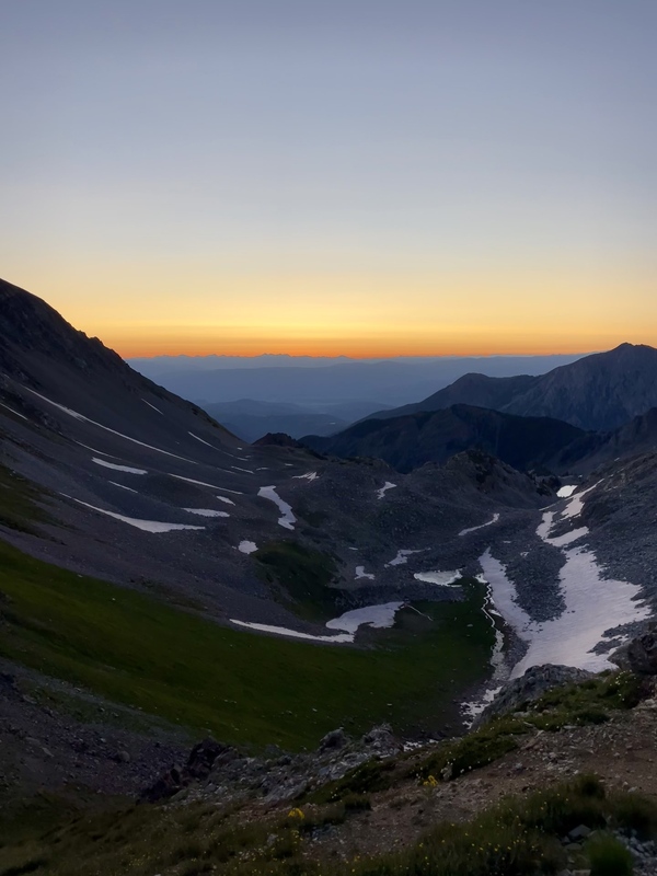
I don't have any photos for K2 on the way up. We chose to go up and over K2 rather than around the side. It was straightforward getting on top. The rock is solid, minimal to no exposure, and just not overly difficult relative to anything we had done in the past or do later in the day. The descent on the other hand was a different story (route depending). I took the slabs on the way down the backside. The difficult spot as described in the route description is a very long reach (I am 6'2 for reference). I managed to make it down with my long reach, but advised my dad behind me to go down off the ridge of K2 on descending climbers right and then crossing over near the bottom. 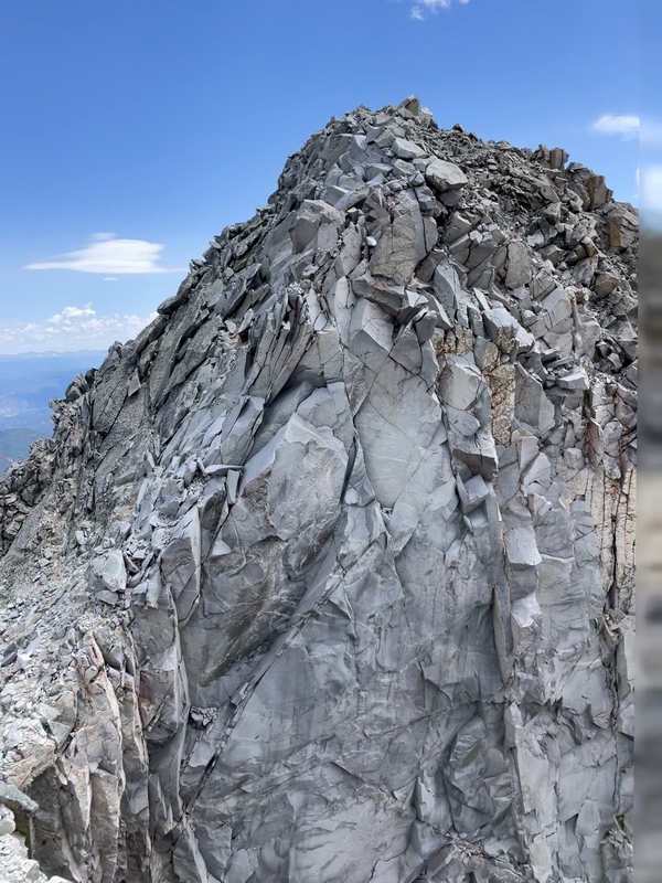
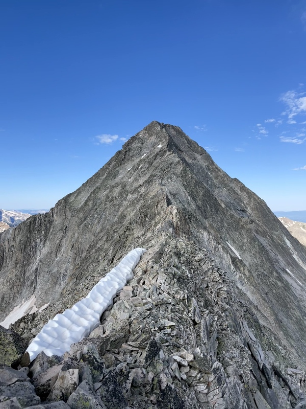
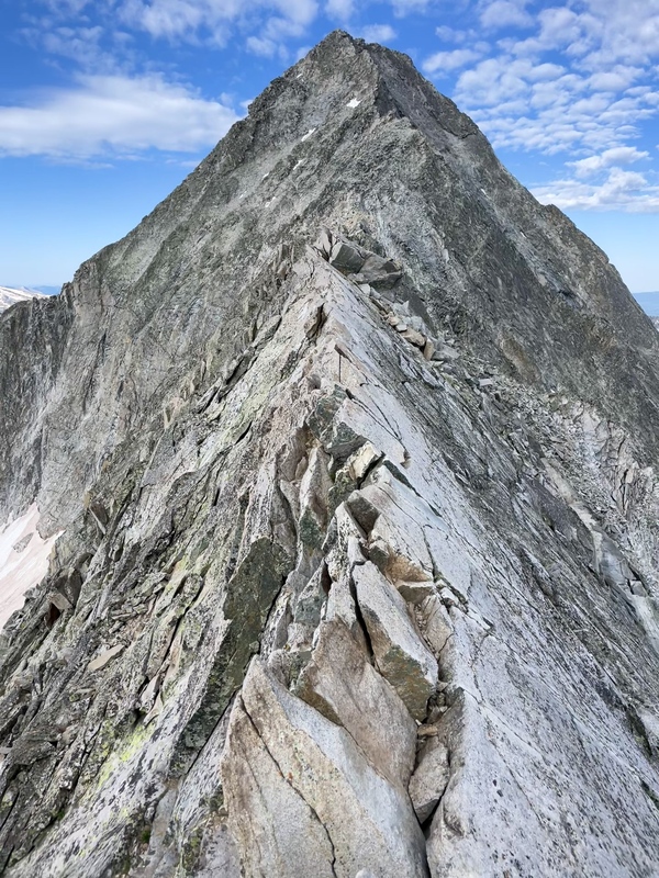
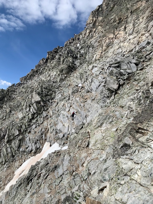
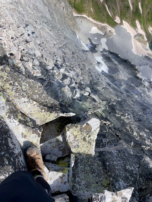
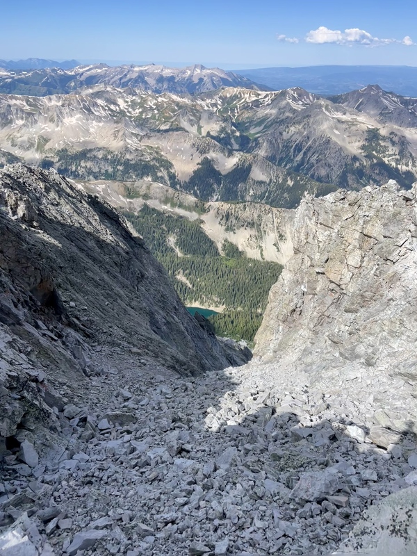
The rest of the route now looms large. It is almost all class 3 and class 4 from here. The exposure is real. The exposure isn't necessarily the difficulty at hand, but rather, the consequence of a mistake. For some, exposure is the difficulty and can keep them from attempting an easy move, and for others, it is just the background of the task at hand. And that is how I view it. If one is careful and can handle the rock in front of them, the exposure becomes an incredible view rather than an obstacle. From K2, the knife edge is about a 15-20 minute scramble away. Again, the exposure is real, but, the rock is solid. We took our time getting across, going one at a time. I led the way, working both sides of the ridge at times. There was a spot in the middle that I didn't feel there was a safe way to keep my feet, and ended up straddling the ridge like riding a horse, scooting myself forward. It took about 10 minutes for the both of us to make it across. 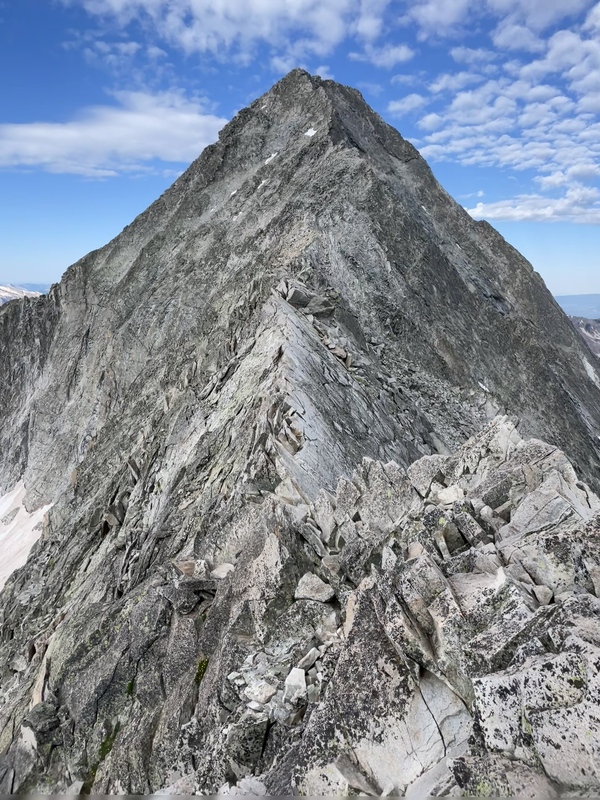
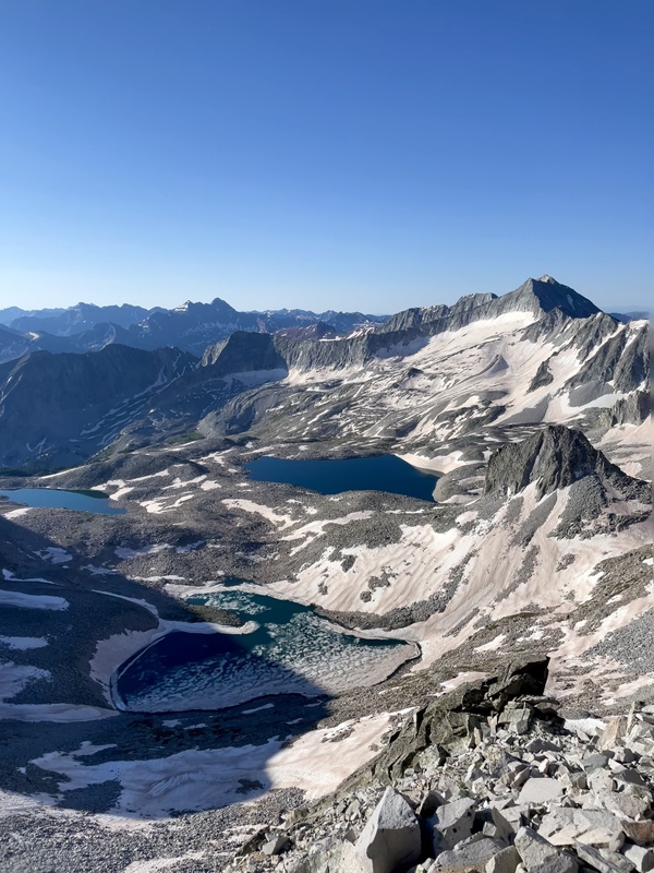
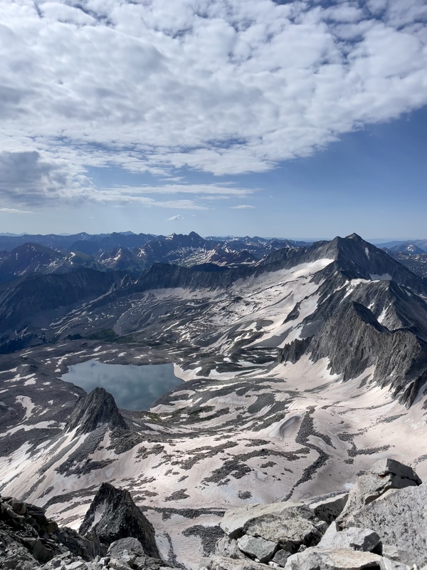
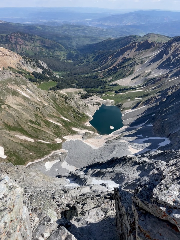
Something that I feel doesn't get enough attention, and rightfully so given the difficulty of the route, is the view of Pierre Lakes basin. It is absolutely stunning and so I took plenty of picture of it. Here is a quick dump of my favorites. 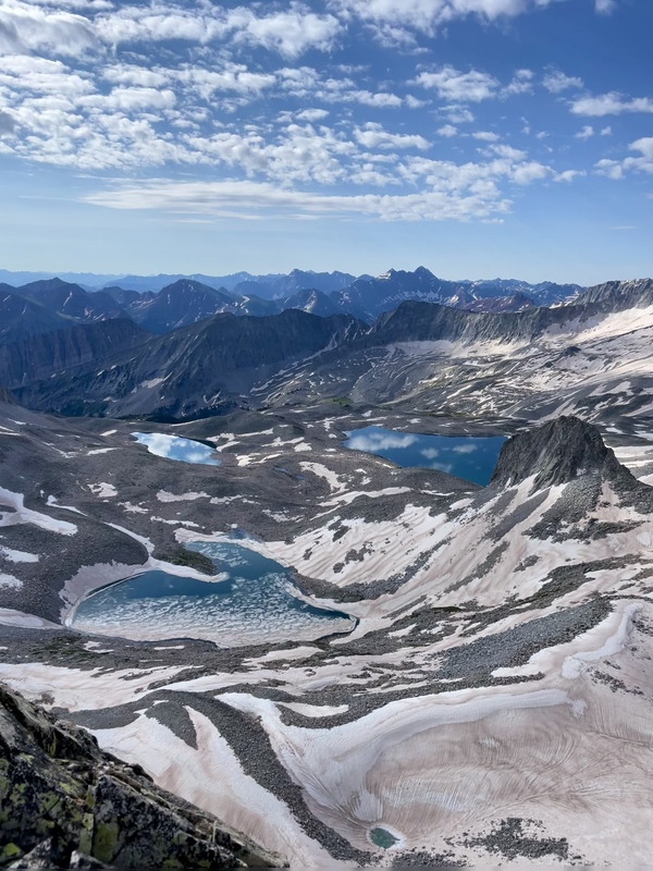
From the knife edge, another 20 minutes of picking our way along the ridge lead to the notch (8:45 am). To play touch and go with this one, this is not an alternate route down. There are no shortcuts. 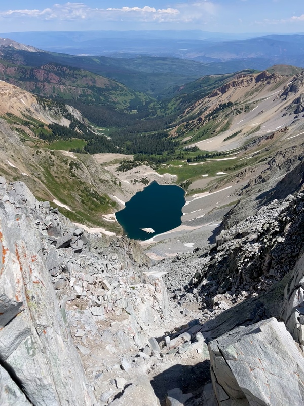

From the notch the route climbs up to the right, almost gaining the ridge, before continuing to parallel the ridge toward the East Face. The East Face is widely considered a crux of the route along with K2 and to others, the knife edge. We had passed the first two with flying colors, and just needed one more. We continued picking our way below the ridge, one move at a time, until we reached the East Face at 9:10 am (almost 4 hours from the Daly-K2 saddle and 1.5 hours from K2). This part was a bit of a blur. There is a lot of beta on this section, and I don't remember much about the route we chose or why. We just aim to find the easiest path forward and I feel the two of us are good at making those calls. There are plenty of other trip reports out there that do a GREAT job of detailing this information, and mine isn't quite up to that level. 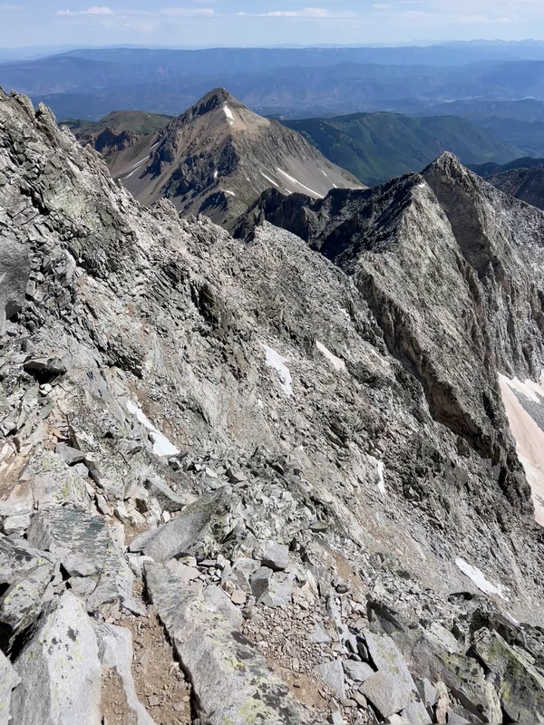
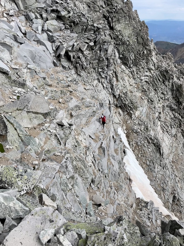
Once past the East Face, we still had a few minutes of scrambling up the ridge to reach the summit. The exposure is absolutely unreal, and exhilarating for those not afraid of heights. 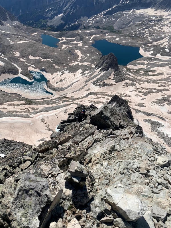
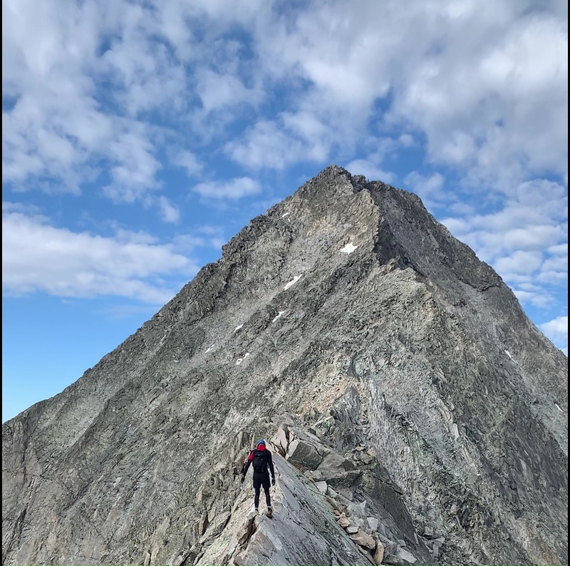
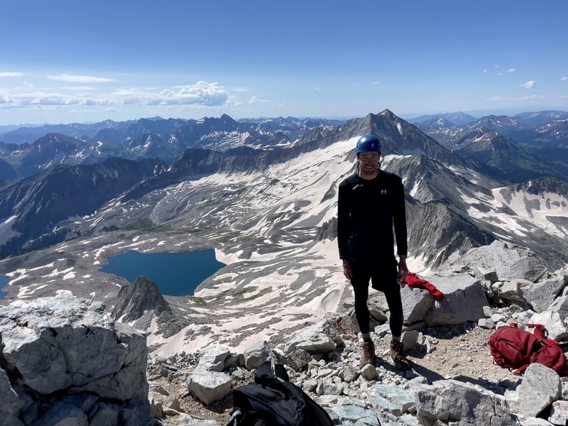
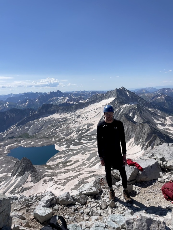
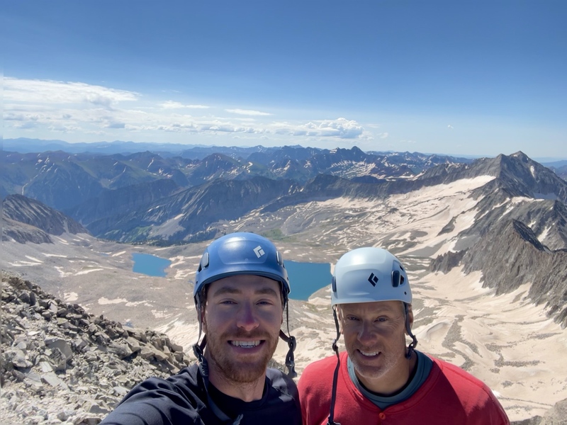
By nature of age, I tend to get ahead of my dad at times. So, once we were both got past the East Face, I took off for the summit, and reached it at 9:35 am. It made for a really cool moment getting to watch my dad crest the ridge and make the final walk to the summit. And it always makes for a really cool picture. 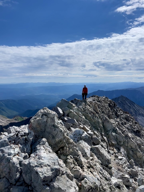
We'd done it! We had done what we once thought to be way out of our league. There aren't many things this side of heaven that can beat sitting on a summit, and this summit may currently have them all beat. We had the summit all to ourselves for all but 5 minutes while another hiker was up there. The weather couldn't have been any better, so we got to take a little extra time to rest, recharge, and refuel. Keep in mind we've already been at it for 5 hours and still have the entire hike out. But for now, we were enjoying the summit. 

With over 8 miles left to hike back to the car, we couldn't stay much longer. It would be just as slow getting back to K2 as it was getting to the summit. Because of the technical difficulty, this hike isn't really over until you get back over K2. You cannot afford to mentally check out and let gravity walk you downhill like the class 1-2 peaks. We left the summit sometime around 10:30 am (almost an hour was spent on the summit) and picked our way down the ridge back to the East Face. We made it back across the East Face by 10:50 am, and that was difficulty one completed on the return. 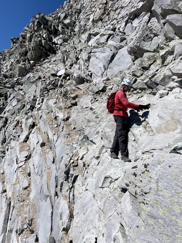
We continued along the ridge, working back down to the notch. My dad snagged this really cool picture of me somewhere along this section. 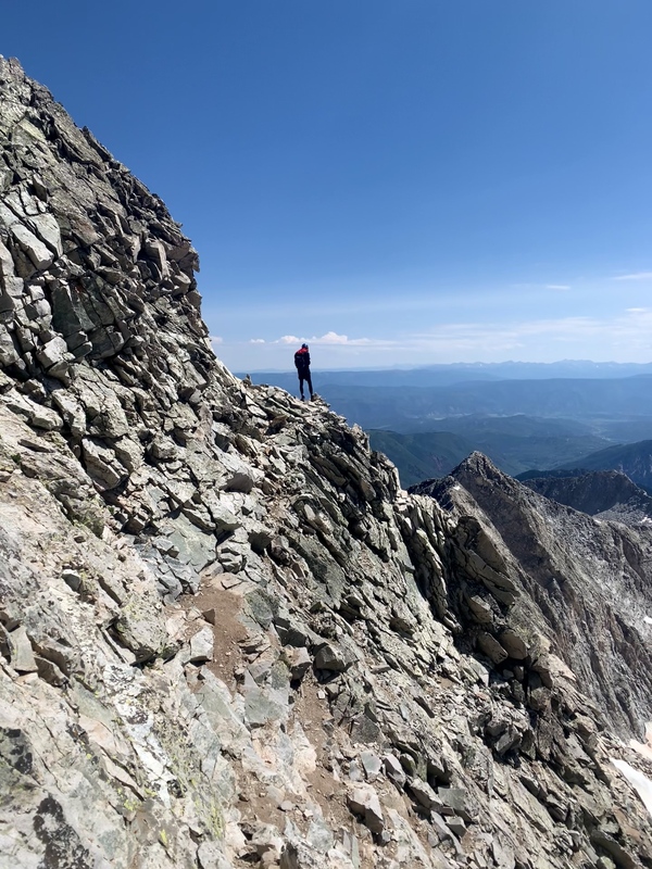
We got to the notch at 11:20 am, 30 minutes after leaving the East Face. Then another 25 minutes of scrambling got us to the knife edge around 11:45 am. I was across it in 3 minutes. 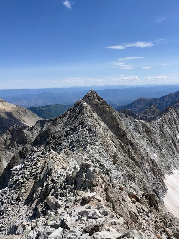
As mentioned earlier in the report, we re-summitted K2 by way of the ridge, climbers left of the class 4 slab descent. We were back on top of K2 by 12:15 pm. We called the family to let them know where we were, that we were okay, and a time estimate on when we would be back. We thought it would be around 7pm. 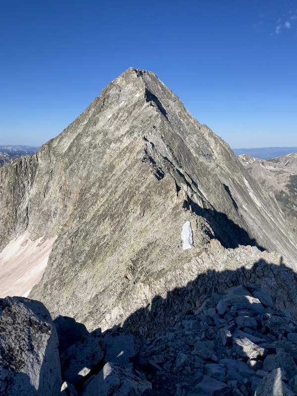
After a quick snack, we were back on the move, leaving K2 around 12:35 pm with the task of finding our axes and spikes where we had stashed them. We got back to the top of the snow fields just before 1 pm, grabbed our gear, and enjoyed some glissades back down that saved time and energy on the return trip. We made quick work from here back to the saddle, taking only 40 minutes. 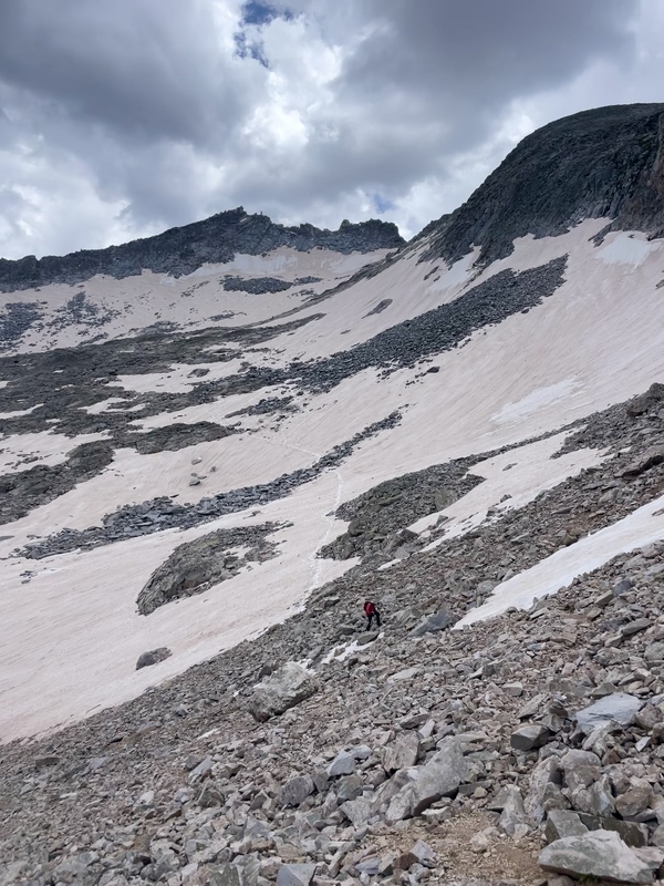
From here, we got our first real good look at Capitol Lake, from up close, in the daylight. I snagged some really cool pictures of it on the way down from the saddle. 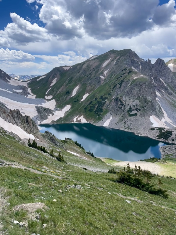
We made it back down to camp by 2:30 pm . We were both out of water (it had been almost 10 hours since we started). So, I let dad filter us some water for the 6 mile hike out while I started packing up camp, which included stuffing the sleeping bags and rolling up the sleeping pads. 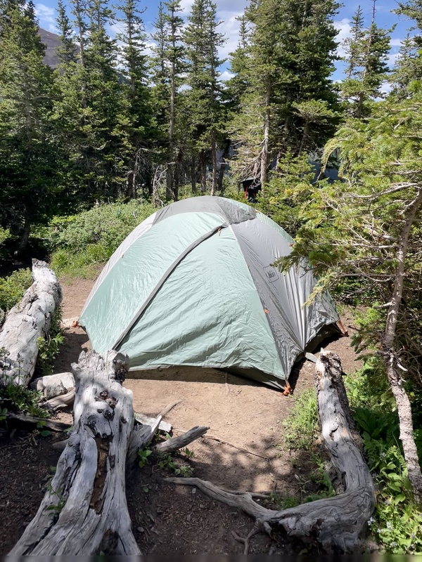
With those tasks done, we refueled one last time and we both got pictures taken with Capitol Peak and the ridge in the background. This one might be my favorite from the day... 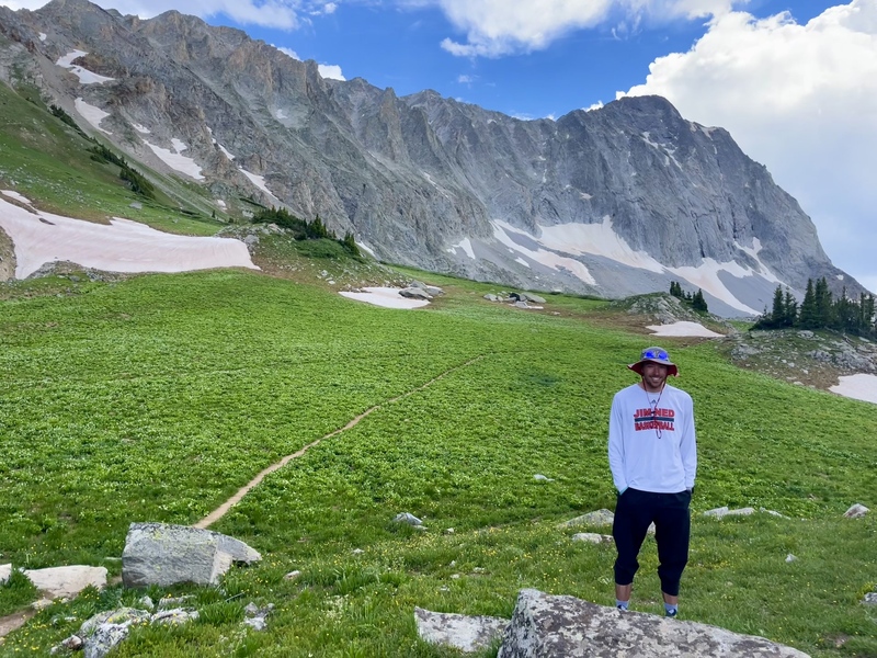
The hike is basically over, so what am I still doing here? It was now 3:30 pm as we departed camp. Normally, this is the part of the hike where you mentally check out and make the trudge back to the car that always feels ten times longer than the trip up did. However, this day proved to be far from over. Unfortunately for me, my stomach began to ache as soon as we left camp. Like actually right once we started walking I first noticed the initial discomfort. I immediately started making mental checks of possibilities as to why. I had eaten plenty of food and drank plenty of water during the hike (which is really good for me, sometimes I am lacking in that area), so I wasn't really sure what the issue was. As we kept walking down the trail, the pain in my stomach continued to intensify. I still didn't think too much of it yet, assuming just a standard stomach ache that would soon go away. After all, it wasn't initially really painful. It was more just a discomfort and I just assumed it would be a trip to the bathroom later in the day. So we kept on hiking. We made it over a stream crossing (the one closest to the lake) where we had to go off the trail to find easy and dry passage across. Just after getting back on the trail on the other side, we informed a solo hiker going up of where we crossed to keep our feet dry, and continued on our way. As we kept walking, my situation kept deteriorating. I soon let my dad know my stomach was feeling off and I needed to stop and go to the bathroom. So we stopped and I wandered a little ways off the trail. After a few minutes, nothing happened. In fact, being in a sitting position had somewhat relieved the pain I was feeling. However, once I was back upright and walking again, my stomach went right back to feeling bad again. I don't believe we made it much further before I called for another stop. Suddenly I began to feel really hot, like my body temperature shot up, so much so that I took my shirt off and was sweating. Then just a couple of minutes later my body did a 180 and I felt really cold, put my shirt back on and my hoodie. We even pulled out one of our sleeping bags for me to cover up with as well. While all this was happening my body rapidly lost all of its energy. So, there I was, curled up on the ground, under a sleeping bag, just 2 feet off the side of the trail. If I had to guess, we were probably only a mile and half down from the lake. I don't think we had passed the no camping zone fence yet. My dad's phone battery was dead and my phone battery was running low. We still had an unused portable charger that we had brought, so I gave my dad my phone and had him plug it in just in case we were going to need it (I had cell service for about the first 3 miles of the hike in). Some of the details get a little blurry at this point as I know a lot of time passed without a whole lot happening. To attempt to describe the situation a little better, I would rate the pain/discomfort at a 6 to 6.5 out of 10. I wasn't in extreme pain but not being able to relieve myself and my energy being zapped was a little odd so I just had a gut feeling that something wasn't quite right but had no clue what. All I knew for sure was that in my current state I could not carry my gear the remaining 4.5 miles to the car. Even walking without carrying anything was doubtful. We had to start contemplating potential next steps. For all we knew this could just be a bad stomach ache, and so my dad decided he would shuttle our backpacks down the trail. The thought was maybe I start feeling a little better and be able to walk some. We also thought in a worst case scenario we could set up camp for the night and hopefully sleep off whatever was wrong. So my dad began took off with his packs down about a half mile or so and then returned. I was not feeling any better. I continued to feel worse. I now had that awful all over feeling you get when you just feel like you need to throw up. It was beginning to set in that I was not going to be hiking out that evening. Eventually my dad took off with my phone to go find some cell service (roughly a mile or two down the trail). Again, I don't really remember the timing of everything but it was probably closing in on 6pm, and possibly even later. It felt like my dad was gone for a long time as I just remained curled up on the ground the whole time. For a fleeting moment, the possibility that I might not make it off the mountain crossed my mind. I mean, how could it not when you're curled up in pain on a mountain by yourself? Could I just fall asleep and not wake back up? To be honest, it didn't really scare me all that much to think about. I would love to quickly explain why. I believe that Jesus Christ is real, and that he died on cross to pay for my sin (and anyone else that would believe in him) and to make a way to be with him in heaven for eternity. And for that reason, I have hope beyond the grave, that there is more than just this life on Earth. And so if that was going to be my last moments on Earth, I knew I'd soon be somewhere better. But that thought was fleeting and pretty soon a couple arrived as they were making their way up to the lake. They stopped to check on me, and the guy was very kind. He thought I might be bonking, which just means that my body is completely depleted and that it just needs some carbs and water to give me some energy. He explained he had experienced something similar in the past, and that refueling his body helped. He gave me 2 chewy granola bars, a Clif bar, a pack of honey stinger energy chews, and refilled my nalgene water bottle. He had also talked to my dad further down the trail and used his Garmin InReach to send a text to my mom regarding the situation. I think it read something like "call your husband, your son is sick." I ate 1 chewy granola bar and the energy chews while sipping on the water and the couple then continued on their way. I was slowly working on the Clif Bar when I suddenly puked up everything I had just eaten. As unpleasant as throwing up was, it was also a relief because it cleared my head a little and relieved some of the overall discomfort I was feeling. Shortly after this, the man that we passed by the stream crossing walked up. It just so happened that he day hiking rather than pursuing Capitol Peak. This may be a miracle as most people hiking back here are doing Capitol Peak. He stopped to check on me and pulled a kit out of his pack. He had a legitimate medical kit with him. Like not just your basic outdoors emergency kit. He had a kit with a lot of things. This man's name is Greg and he became an integral part of the rest of this story. Turns out Greg was an EMT (currently retired, but keeps his license up to date). Greg pulled an oximeter out of his kit to check my pulse and blood oxygen level. Both were reading really well. He asked me questions and I explained my symptoms, what was going on, and what had happened so far. Greg was also carrying a SAT phone and started using that to communicate with search and rescue about the situation. We were currently in a wooded area which caused him to lose connection frequently. Again, at this point I was feeling a little better since throwing up and I only have the stomach pain, lack of energy, and chills. My dad eventually returned and we decided that I would try to walk without any gear and see how I felt. Walking was more difficult than it had ever been in my life. The lack of energy my body had showed in the shaking of my legs with every slow step I took. And when I say slow, think like 1 step every 2 seconds. I probably looked pathetic! The stomach pain while lying down and curled up was not as bad, but once I was back upright and walking the pain immediately returned. We barely made it quarter mile before we concluded this wasn't going to work for another 4+ miles. The one positive was that moving got us out of the wooded area and into a flat, clear, and grassy area. 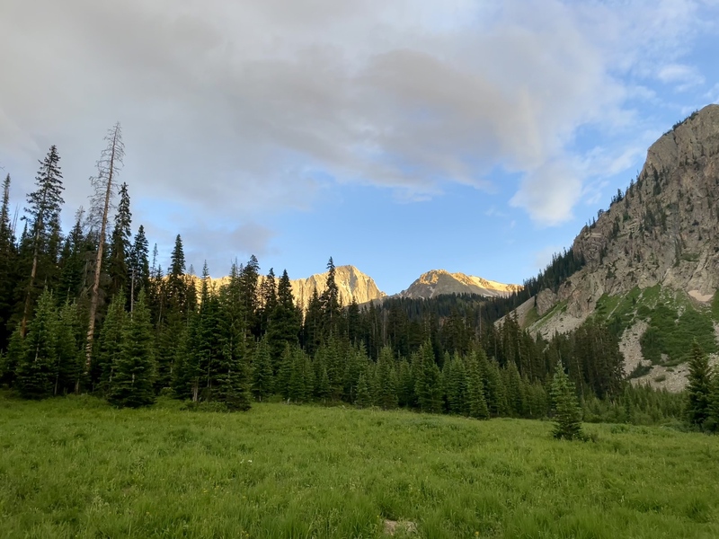
Greg maintained communication with SAR on the situation the whole time. It was probably 7:30-8pm and a ground team was on their way to the trailhead. However, Greg was still pushing for a helicopter. He got into a somewhat humorous back and forth as the other end of the phone was thinking the area was too slanted for a helicopter to land and he became very adamant that it was possible, stating he had seen helicopters land on worse. Finally, a helicopter was on its way to us from Frisco. We waited about 30-45 minutes for the helicopter to arrive while I remained curled up under the sleeping bag. When the helicopter arrived, Greg took my blue sleeping bag to signal where we were and it circled around and landed nearby (this is why it was good that I got up and walked a little because it got us to a spot the helicopter could get me). They got out and checked on me and I walked over to the helicopter and got in on the little gurney it had, and we lifted off just before 9pm. The flight to Aspen Valley ER offered stunning views up the Maroon Bells valley and only lasted only about 5 minutes. Now, let me stop and rewind here for second. If you recall, the guy with the Garmin InReach sent a text to my mom. We had also communicated with our family that we would be back to the campground around 7pm. Ruedi Reservoir does not have cell service so our family was completely in the dark about everything that has happened so far. I believe around 7:30-8pm my mom and sister began to get worried. However, my brother had been telling them to wait a little longer, that once they started driving down to Basalt we would just pass them on our way up. More time passed, so eventually my mom and sister drove down to get cell service. I think at worst they were just worried about car troubles because we had already told them we were through all the technical terrain. However, they received a text from an unknown number (the Garmin InReach) that read, "Call your husband, your son is sick" and "Hold off 911 for now." While he had hiked down, my dad had also gotten ahold of my mom's dad, seeking some advice, as he is a former firefighter and was wondering if an appendix issue was a possibility. So my grandparents had been in contact with the Basalt PD and my mom found that out as well. They got hit with a lot of serious but vague information and the realization that we were no where close to being back. Meanwhile, back in the ER, a doctor performed what is called a rebound test. He applied pressure to my abdomen on my left side and asked about a pain response, and then the right side, asking about a pain response again. There was a light pain kind of in my central abdomen when pressure was applied on the left side. When the pressure was applied on my right side, the pain was immense. Immediately, the doctor believed I had appendicitis, and set up a CT scan just to confirm. This was the worst moment of the day as I was required to lie fully reclined on my back and had to extend my arms out above my head. Fully stretching out my abdomen caused the most severe pain of the night, and this was after they had administered some pain meds upon my arrival. The ER also got my mom's phone number from me before taking me back and so eventually my mom and sister were on their way to the ER with the relief of knowing that both dad and I were alive. While waiting for my mom to arrive, the doctor came back with the results of the CT scan. To the surprise of the doctor, I did not have appendicitis. He stated I had cecal volvulus. For those not familiar with medical terms, my large intestine had twisted on itself causing an obstruction. This was only possible due to a congenital defect where the large intestine is not secured to the abdomen wall. Therefore, it was able to move around freely. This can happen often, but it can usually resolve itself so quickly that you may not even have symptoms or only have discomfort for a short period of time. Unfortunately for me that was not the case. 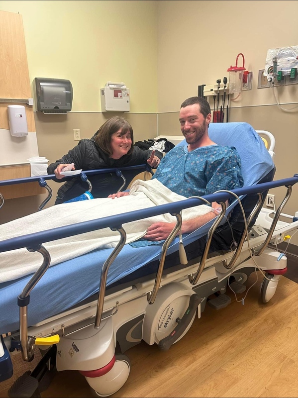
My mom and sister finally arrived at the ER and to the room I was being held in and I got to tell them everything that had happened and we had a little laugh about it. We laughed about how this was going to get a page in the picture book my sister makes for every Colorado vacation we take. The surgeon then came in and explained the situation to us and that I would need an emergency surgery to fix my large intestine. To switch gears again, when I left the mountain in the helicopter, none of my gear could go with me, so Greg, being the outstanding human being he is, shouldered my big backpacking pack while my dad had his gear plus my day pack, and they hiked the remaining 4+ miles back to the trailhead together, reaching it around 11pm. We are both extremely grateful for the way Greg went out of his way and sacrificed so much time and energy to help me and my dad. It is very possible I would not be here today if it wasn't for Greg's help and his SAT phone. It wasn't until the surgeon talked to my mom after the surgery that we found out how serious things really were. The surgeon told my mom that the right call was made in getting a helicopter evacuation as he estimated that I only had about an hour longer from the time of surgery before the obstruction would have burst which would have complicated things to a whole different level (sepsis and then septic shock if not treated promptly). My intestine had been obstructed long enough that some tissue had started to die. This resulted in the removal of portions of both my large and small intestine. Thankfully though, by the grace of God, everything ended up okay and the surgery was successful. I found out later they wrote an article in the newspaper about the rescue. 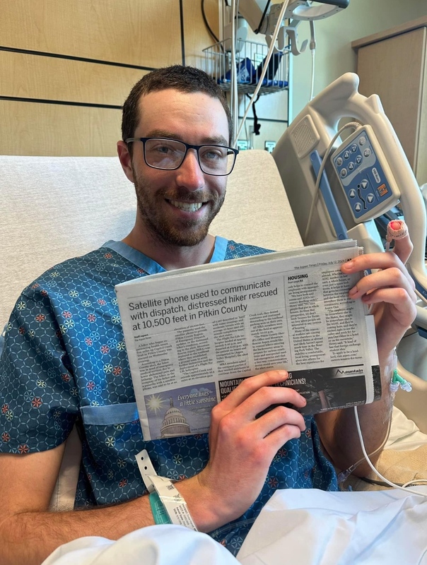
Looking back, I don’t believe any of it was an accident. I’m alive today by the grace of God, because of how every piece fell into place when it needed to. There were countless ways that day could have ended differently. In another place, or under different circumstances, I might have ignored the signs, tried to sleep it off, and never made it to help in time. But that’s not how it unfolded. Greg was there with a satellite phone, with the awareness to check on me, and with the willingness to step in without hesitation. Because of him, everything moved faster, and I made it off that trail. I’ll never forget his kindness, or the way he showed up when it mattered most. More than anything, I see God’s hand in all of it. In the timing, in the people, and in the outcome. I believe He had a plan that day, and still does, weaving moments like this into something bigger than I can fully understand. If my story can point to His goodness, His mercy, and His grace, then it has a purpose beyond just what happened to me. And when I think back to the mountains, I’m reminded not only of how fragile life can be, but also of how small we are in the presence of something so vast, and how, even there, we are never beyond His reach. Thumbnails for uploaded photos (click to open slideshow):  Views of Pierre Basin, Snowmass, and Bells")
 Camp")
")
 Summit ridge exposure; Capitol Lake below")
 Capitol from the trail")
 Capitol from the trail")
 Capitol from the trail head")
 Capitol Lake seen from above on the descent")
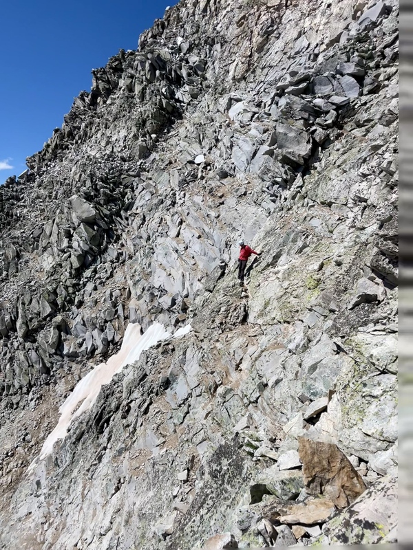
 Dad crossing the east face")
 Dad returning across the east face")
 Dad in the middle of the east face")
 Dad about to summit")
 Return route seen from above the east face")
 Moments before disaster")
 Empty east face")
 Looking down the summit ridge at Pierre Lakes with myself in view")
 Me on the summit")
 Me on the summit")
 Dad takes some cool pictures of me from behind")
 East face again")
 Evening sun hitting Capitol and the ridge")
 Later evening sun on Capitol")
 Exposure over Capitol Lake")
 Helicopter landing zone")
 K2 upon returning")
 Knife Edge")
 Knife Edge, a little closer")
 Just past K2, the route ahead")
 Pierre Lakes and the Bells")
 Pierre Lakes and the Bells")
 Pierre Lakes and Snowmass")
 Return route")
 Looking back on return route in the basin")
 The wrong gulley...")
 A cool secluded lake seen from the summit of Capitol")
 Packed and ready to go")
 Snow ascent")
 Snow crossings")
 Standing on the knife edge")
 Exposure on the summit ridge")
 Summit selfie with Dad and the Bells")
 Summit selfie with Dad and Snowmass")
 Summit snack!!!")
 Sunrise from the K2-Daly saddle")
 Sunset and time for bed. Big day tomorrow")
 I just really like picture that capture the trail in the foreground")
 Trail split before stream crossing")
 Water filter spot with a great sunset")
 Post operation")
 ER Room")
|
| Comments or Questions | |||
|---|---|---|---|
|
Caution: The information contained in this report may not be accurate and should not be the only resource used in preparation for your climb. Failure to have the necessary experience, physical conditioning, supplies or equipment can result in injury or death. 14ers.com and the author(s) of this report provide no warranties, either express or implied, that the information provided is accurate or reliable. By using the information provided, you agree to indemnify and hold harmless 14ers.com and the report author(s) with respect to any claims and demands against them, including any attorney fees and expenses. Please read the 14ers.com Safety and Disclaimer pages for more information.
Please respect private property: 14ers.com supports the rights of private landowners to determine how and by whom their land will be used. In Colorado, it is your responsibility to determine if land is private and to obtain the appropriate permission before entering the property.


