| Report Type | Full |
| Peak(s) |
Pilot Knob - 13,746 feet Golden Horn - 13,789 feet Vermilion Peak - 13,909 feet Fuller Peak - 13,777 feet Beattie Peak - 13,351 feet Unnamed 13302 - 13,302 feet "V 9" - 13,244 feet Rolling Mountain - 13,697 feet |
| Date Posted | 01/31/2025 |
| Modified | 03/03/2025 |
| Date Climbed | 09/09/2024 |
| Author | Ngrage1127 |
| Rollin over to Rolling - Pilot Knob to Rolling Mtn |
|---|
|
Back in September, I got to go up to the Ice Lakes Basin for the first time. I headed off on Friday evening after a busy week of class in Durango. The weekend prior, I had done a big day in the La Plata Mountains with my friend Jack, which I just recently posted a report on. After a week of rest, I felt like I'd given myself time to heal up and would be psyched to be back in the mountains. I had never seen the Ice Lakes before, one of the more popular outings around the San Juans, so I figured I would just go climb Pilot Knob and see how I felt. I'd heard that Pilot Knob was an interesting outing from a couple of friends the week before, and I've always admired the funky summit from surrounding areas. I car-camped right outside of Silverton and set my alarm for 4:30 am the next day.
Sunset above Golden Horn I got off around 5:30 after trying to hype myself up more than usual. I noticed I felt unmotivated in the dark, possibly a bit fried from recent efforts. My body felt great, but my head wasn't really in it. Deep down, I was wishing I'd slept in. Unable to shake this headspace off, I figured I would just go see the lakes at the very least. Considering I'd driven up here and slept in my car. I'm not great with sunk cost...
Sunrise on Golden Horn / Looking down into ~Silverton When I got my first peek of Ice Lake, with the sun warming me up and basking the cirque in orange light, I felt lighter! I was stunned by how deep blue the lake was, even though it hadn't been hit by the sun yet. These are some real gems. Unfortunately, there were a couple of guys camping right on the shore, not good-style boys! They were nice, and I didn't feel like altering their joyous morning, so I just kept it moving!
Ice Lake - Zero filters or camera work, it's really that blue! With a lot more pep, I carried on toward Pilot Knob. Getting up to the final scramble is a bit cryptic. The standard way up the summit outcropping is on the West side, while the Ice Lakes sit on the east side. My strategy was to aim directly under the summit of the outcropping on the East side; I followed an eroded and loose slope out of the basin, which put me just below the Summit on the east side. From here, you wrap around the North end of the peak and contour around for a bit until you reach an obvious and cleaned-off gully scramble. this brief section deposits you along Pilot Knob's Summit ridge.
Pilot Knob a few Weeks Later - Note the yellow/orange streak down the slope, directly under the highest point (right.) This was my path through this section.
Almost up to the ridge under the summit of Pilot Knob, looking northeast along the strange formation that spans over to V4
Views west to the Wilson group. At this point, contouring around the N side of Pilot Knob
Layer after layer - Looking into the Weminuche. Trinities/Vestal/Arrow on the left - Jagged in the center - Chicago basin right of center - Pigeon far right I made it onto the final summit ridge around 8:30 and made my way over to the distinct crux. The terrain here is epic.
Summit ridgeline - Golden horn, Vermilion, and Fuller in line along the ridge.
Summit of Pilot Knob. Feeling rejuvenated and proud of my decision to push through the early morning doubts. Sunshine feeling amazing.
US Grant dominates the view, V4 disguised in front of it. Another view of the wild formation between PK and V4. Wetterhorn/Unc to the left of USG
Nabbed a picture of the crux on the way back. Beware, you must downclimb a very exposed seam that can be seen just under the huge block. The crux is much easier to reverse than to initially downclimb. It is hard to tell right here, but if you blow the downclimb, it will be fatal. While only a measly 10-foot section, just make sure you're sharp! At this point, I decided to carry on with my day and go for an adventure. I spent a bit of time looking at a few maps, realizing there were plenty of escapes back into the Ice Lakes Basin. As well, there was a road stretching close to Rolling Mountain, which was kind of a natural termination of the ridge. It was good to know I had options if I lost my psych or the weather came through... (I did see a chance of storms around three on the forecast)
Contouring under the West side of PK's upper outcropping. This section really sucks... for anyone combining PK and Golden Horn, just know you will likely be on all fours and crawling sideways at some point. I can confidently say there is no graceful way to do this section. There is no REAL danger, but it didn't seem impossible to start rolling down the west side of Pilot Knob! San Juan Choss at its finest!
Saddle between PK and Golden Horn. Finally on solid ground. Easy traverse over to GH. Note the twin summits!
View of the East side of Pilot Knob. The summit is the farthest right point, and the giant block at the crux is just below to the left. Golden Horn went quickly, once off the ridiculous West side of PK it was smooth sailing. I went up both summits of Golden Horn as I was a bit unsure at first which was the highest. They are easy to combine, and I would recommend going to the farther east summit for a better view of the lakes.
View from the higher Summit, looking at the piercing blue Ice lake. From here you're unable to see the gash between the twin summits. I continued on to Vermillion, sticking along the ridgeline. I was able to stay direct until I had to cut left onto the N/NE face when the ridge became impassable. I grabbed very few pictures in this section. It was kinda gnarly, and an easier route likely exists. I remember being in a few semi-frozen dirt gullies and the movement being a bit desperate. I did come across a few tricker sections along the ridge from Golden Horn.
Looking back at the ground covered so far before I dipped onto the face and off of the ridge. I soaked up the beauty on top of Vermillion, trying to consider how I felt continuing on, and at which point I should bail off of the ridgeline. Around this point, my eyes became fixated on Rolling Mountain in the distance, as well as the Highway of a ridgeline connecting to Fuller. It seemed to be a logical extension for my day, with not too much hassle from the summit of Rolling back to the car. So, I set off down to the summit of Fuller, which wasn't the most notable peak in recent memory! By 11 am, I was on the summit of "Beattie" 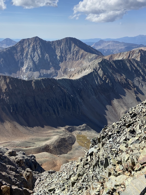 Rolling Mountain basking in the sunshine. That's where we're going!
Summit of Fuller. Beattie, V8, and V9 are the respective points along the upcoming ridge. V8 shining in the sun. Grizzly and V10 in the background. La Plata's doing their own thing in the distance. (Left)
Big Verm out left, Fuller on the right. The obvious trail descending from the saddle was better than I'd imagined and could run down most of it. Beattie to V8 was honestly amazing! While it's not necessarily interesting movement, it's a textbook ridgeline that is essentially flat. I thoroughly enjoyed this section, feeling like I was walking on an alpine sidewalk.
A couple of shots of this lovely section. To the Left of the ridge is Rolling. Off the right side is San Miguel Peak and the red body of Lake Point... as well as some building clouds. After the dreamy ridge, I was slapped in the face by a pretty wack and steep descent to the saddle of V8 and V9. Nothing redeemable about this section, would be a lot nicer to go up than down, I think.
Steep choss descent to the Saddle. Views of the Lake Hope basin make up for it. Grizzly - V10 - San Miguel - Lake Point - Dark Wilson's (L - R)
V9 was fine, a bit thoughtful and loose, honestly, but it felt nice to do a little bit of scrambling after a lot of leg work. I assume this ridgeline is what others have taken. Possibly, there is another route up V9, but this route was direct and went pretty quickly! Likely easier going up than down as well. From the summit of V9, I was becoming more and more aware of the buildup of clouds starting to envelop the San Miguels, I knew I could head back down V9 and descend to the road if I needed to... I sat with it for a moment and decided to hoof it up Rolling. I wouldn't recommend the North side of Rolling, nothing redeemable, really. It was a tad bit dicey, but I think it would be much worse with other people. There were a couple of instances of remotely triggered rockfall while I was going up. It's probably only class three, but there are sections with a steep angle that you really can't get any sort of footing. I wished I had my approach shoes in this section rather than my clapped-out pair of Ribelles with no edge.
Looking up at the rather nasty North side of Rolling. I went directly up the middle of the right "summit" I continued to the true summit (the left one) and found myself on top of Rolling Mountain at 1:30.
Rolling summit baby! I took a couple of pictures, had a brief snack, and started bombing down Rolling, trying to separate myself from the building clouds. By 2 pm, the rain and snow were in full force. Luckily, the terrain was perfect for downhill running, and I had already gained some distance from the upper reaches. I followed my nose, with a bit of bushwacking and willows, and found my way to a trail and subsequent road that heads up back to the Ice Lakes trailhead. The air was noticeably different from the previous few weeks. You could feel the chill of fall in the wind, see the first leaves on the ground, and smell the dying plants. I love fall.
By 3 o'clock, 9.5 hours after setting off, I was enjoying a nice brew and changing into a dry pair of clothes. I had a nice jog down the road, reminiscing on the terrain covered throughout the day. Thumbnails for uploaded photos (click to open slideshow): ")
")
")
")
")
")
")
")
")
")
")
")
")
")
")
")
")
")
")
")
")
")
")
")
")
")
")
|
| Comments or Questions | ||||||
|---|---|---|---|---|---|---|
|
Caution: The information contained in this report may not be accurate and should not be the only resource used in preparation for your climb. Failure to have the necessary experience, physical conditioning, supplies or equipment can result in injury or death. 14ers.com and the author(s) of this report provide no warranties, either express or implied, that the information provided is accurate or reliable. By using the information provided, you agree to indemnify and hold harmless 14ers.com and the report author(s) with respect to any claims and demands against them, including any attorney fees and expenses. Please read the 14ers.com Safety and Disclaimer pages for more information.
Please respect private property: 14ers.com supports the rights of private landowners to determine how and by whom their land will be used. In Colorado, it is your responsibility to determine if land is private and to obtain the appropriate permission before entering the property.


