| Report Type | Full |
| Peak(s) |
Crestone Peak - 14,299 feet Crestone Needle - 14,196 feet |
| Date Posted | 01/20/2025 |
| Date Climbed | 01/14/2025 |
| Author | daway8 |
| Winter Crestones: A Saga of Endurance |
|---|
|
When I set my sites on doing the Crestones in winter, little did I know that it would take me 5 attempts over the span of about a month to get these 2 snowflakes, and I never imagined that the successful summit of Crestone Needle would take just over 24hrs trailhead to trailhead. This is not an account of an elite mountaineer conquering peaks. This is not a textbook of how to properly scale class 3 and 4+ mountains in winter. This is the tale of someone with an obsession for the rugged and wild beauty of alpine winters who got in over his head but managed, despite many blunders, to summit and not die. I intend to be honest about where I made mistakes, informative about where I learned useful information, and detailed enough in my descriptions that those who may want to try these peaks themselves in winter can learn from both my observations and my blunders and those who already know, or decide after reading this, that they never want to do them in winter can at least experience the thrill of defeat and the agony of victory as I try to vividly recreate the breathtaking beauty, soul-crushing effort, and bone-chilling cold that make the Winter Crestones an unforgettable experience! Stats: Crestone Peak successful summit 12/26/24: 11.5mi RT, 6,100ft gain. From Cottonwood Creek Trailhead, then connect to standard summer route below Red Gully. Time trailhead to trailhead: ~16hrs (phone died near the end) Crestone Needle successful summit 1/14/25: 12.25mi, 5,900ft gain. From Cottonwood Creek Trailhead, then connect to standard summer route at Broken Hand Pass. Time trailhead to trailhead: 24hrs 20min (including blunders) Team: All these hikes started and ended solo but for several of them I ended up meeting up with other people for at least some portion of the hike. In addition I feel it appropriate to give credit for the "temporally displaced teamwork" involved in these efforts - that is, even though in some cases I never even saw other people, I benefitted to varying degrees from their trenching and/or beta. In particular, prior to and during CP attempt 1, credit is given to bigfoot1 (Emily) for both beta and trenching. Luis (grizel) and Mike played leapfrog on the approach for CP take 2, with Mike taking special credit for plowing steps up the Red Gully. Also somewhere around that time, Alec and his teammate had put in some tracks first to CP then to Needle. Emily caught up to me again on trail on my second Needle attempt. Then the final success on Needle was as solo as it gets, but not without the benefit of all those who helped keep the approach trail trenched. Thanks to all of you and anyone else who helped trench, and retrench the approach! Included in this looong report will be the following sections (click the blue hyperlinks to quickly jump down to the section of interest if you don't want to read the full TR - thanks Tiff for showing me how to use anchors and links on the TR page to put hyperlinks to a section within a report! Very handy for a long report like this where someone wants to quickly get to specific info...)
DISCLAIMER: Winter 14ers are difficult and dangerous! For the harder 14ers, avalanche danger is basically never zero - there is always some risk. Additionally, wind chills in winter often reach negative double-digits, which can cause frostbite in less than 10 minutes. Slipping hazards are far greater on class 3 and above in winter. In short, it is much easier to die in the mountains in winter in many more ways than you will typically encounter in summer. Anyone attempting to climb these peaks based off of information in this report assumes the full risk of death as an inherent possibility in such an endeavor. Stay safe folks - preferably safer than I stayed! 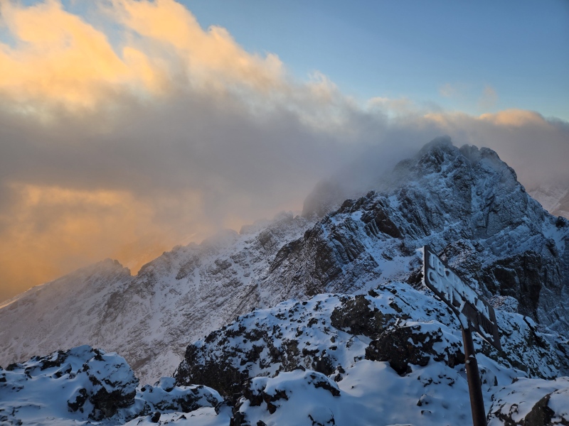
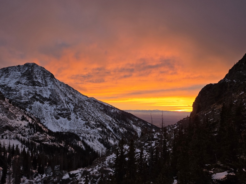
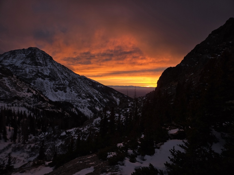
The Elements (by TobyMac - excerpted) I lace the boots up, it's straight to the door And I'mma go down swinging, if I go down Backstory So why would anyone subject themselves to the degree of suffering that you've already been given a foretaste of in the intro? Well, the photo above is one answer - you just don't encounter the same degree of awe-inspiring beauty in summer - it's almost like the difference between a lady sitting on her couch in her pajamas vs decked out in the most elegant wedding dress - sure, the beauty is still present in summer, but it's far more eye-popping in winter! There's also a much greater challenge involved in winter. Trenching through snow. Scrambling over rocks covered with snow and ice. Negative double-digit wind chills. Shorter daylight hours. All these aspects and more transform the experience even for a normal summer walk-up peak, and all the more so for ones that require some degree of scrambling/climbing even in summer. But no honest answer could exclude the word obsession. How could you not get hooked on the drama, beauty, and challenge - the complete separation from the rest of the world and its troubles and cares; the total wild freedom and majesty of mountains that can literally kill you with their beauty? Well, very easily, some of you might say. If so, you apparently aren't infected with the same delightful disease I have. No worries, I'm happy to help those of you who will never go up these peaks in winter to experience a small taste of what fuels my addiction. Lastly, although list-chasing is now very low of my list of things to do, it must be stated that I am indeed eyeing the possibility of trying to finish all 58 (well 59 actually, if you include North Massive) 14ers in calendar winter. In fact, I had originally planned to make an attempt on Capitol at the start of this winter, but schedules, weather and avalanche danger didn't align for that to happen, so upon seeing favorable conditions in the Sangres, I set my sites on the Crestones instead. In retrospect, I'm very glad it worked out this way because I feel like these two peaks, and everything I experienced while attempting and eventually doing them, are an excellent preparation for Capitol in winter - which I'm still hoping to possibly fit in towards the end of winter, if/when avalanche conditions stabilize and hopefully after getting some more winter camping under my belt (since Capitol will very obviously not be a winter day hike for me). Avalanche Danger and Weather This is a very critical topic in winter, especially for these routes. You're basically going up couloirs on these peaks and one oft repeated fact about winter climbing is that couloirs are generally not considered safe until spring. I certainly did not ignore that fact as I prepared for these climbs. But I concluded that given the specific circumstances of this particular winter, I felt like I had a window of opportunity. As stated in the disclaimer near the top of the report, avalanche danger is almost never zero on the harder peaks, even if the CAIC forecast map is green. I want to highlight some of the reasoning I used to conclude that the level of risk was tolerable for my situation. In doing so, I hope to highlight some of the considerations which I highly encourage anyone considering these peaks to carefully take into account in trying to assess the level of risk on any occasion you might attempt these peaks. Some principles to consider:
In my case, the entire Sangre de Cristo range had been solid green across all aspects and elevations and with no avalanche problems listed and this condition was persisting for several weeks. This is very unusual in winter and so opened up the possibility that these routes might be safe. In the specific case of my final, successful attempt on Crestone Needle, there was a last minute snowstorm that most of the weather stations didn't call out in advance. But CAIC saw it coming and spiked the Sangres yellow (moderate) in advance of the storm only to drop it back to green after seeing it wasn't delivering much and then went to an odd yellow stripe near treeline after it was done. It was a highly sporadic storm. CDOT webcams showed hit and miss areas that were totally dry on the west side of the Sangres (the direction I would be coming from) but decent snow on the east side and mixed results to the north and south. But the problem identified of Persistent Slab was listed as "small" "possible" danger near treeline only on NW to N to E slopes - basically on the opposite side of the ridge from where the East Gully going up Crestone Needle is, and down at lower elevations than where the gully is. There was, however, some verbiage in the discussion about cross-loaded gullies, which is essentially what the routes up the Crestones are. But the gullies for both peaks are facing such that they get hit with sun and wind pretty good. 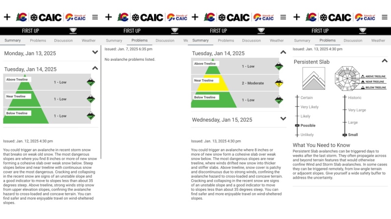
I did also have some concern about crossing from Broken Hand Pass to the base of the East Gully on Crestone Needle, especially after encountering a stiff slab on the slopes under one of the gendarmes coming over from the pass. But I concluded that fit the description in the discussion section below that said "In some places, like wind-hammered alpine terrain, that slab and the old snow below it may be too stiff or stuck in place to fracture and avalanche..." But again, avalanche danger is basically never completely zero if there's enough there to slide, so there's always some degree of possible risk. However, I believe I recently saw the stat that 95% of avy incidents match with where CAIC specifically highlighted those slopes in the problems section, and I stayed well clear of those identified areas at all times. 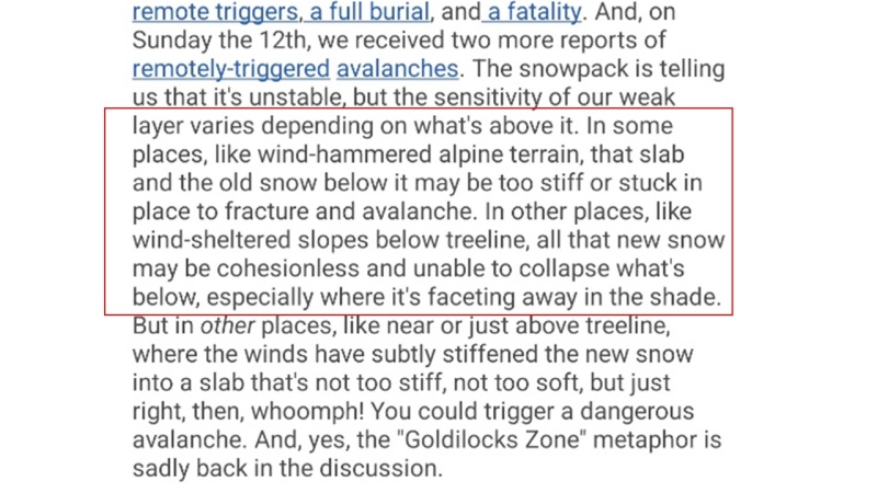
Lastly, one more component of many to consider is the weather. My first attempt at Crestone Peak was aborted in part due to concerns about how hot the sun was getting and seeing water trickle down the Red Gully. I didn't want to test what that level of heat might do the the stability of the snow. Contrast that with the forecast for Crestone Needle on the day of the successful summit where the temperature even at the trailhead never got above freezing and the high on the summit barely ever made it out of sub-zero range. With such bitterly cold weather, I knew I could at least take the melting snow card out of the pile of variables and thus remove at least one of many possible triggers. So to sum up, all indications were that avy conditions in the Sangres were about as low as you can reasonably expect to ever see them in winter and the small, possible issues that crept up on CAIC at the last minute were on the opposite side of the ridge from where I would be. I also stayed alert throughout the day and did not ever see any signs of concerning conditions (though, of course, avalanches don't always give warning signs first...). As such, do you homework and take the danger seriously. If the gullies on either of these peaks did ever slide while you were on them you would almost certainly die. Be warned! Staying on top of the weather can be as critical as staying on top of the avy forecasts. My preferred weather services to check are: OpenSnow: You can click on the map to get weather at the summit, trailhead or anywhere in between (temperature and likely wind at different elevations, etc). Shows temperature, wind chill, wind speed, cloud cover, etc as a graph across the day. Also shows snow predictions for coming week and accumulations over the past week and over the season, etc. NOAA: This is the service linked from the 14ers page - gives concise written descriptions with temp, wind chill, highs/lows, etc. Can scroll down and click graph for hourly plots. Mountain-Forecast: This website is my least favorite of the 3 but I like the drop-down for summit, base and middle elevation forecast to look at temperatures, winds, etc at different elevations. Sometimes useful to have another opinion if OS and NOAA differ. CAIC: Mainly think of them for avalanche forecasts but since the avy forecast is so dependent on weather forecast, they do have a weather tab in their app which can be useful as another source. 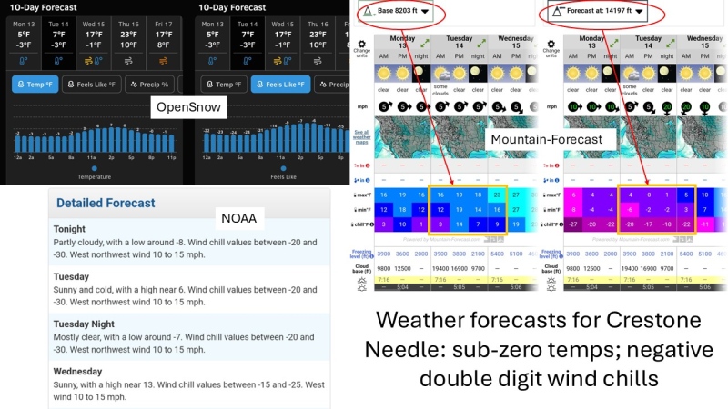
Beta Overview This section is intended mainly for those who take the "save the drama for yo mama" approach and just want a quick overview of the most useful beta. In other words, the sterilized basics that are very useful to known, extracted out from the raw, experiential descriptions in The Journeys section below. Trailhead: Cottonwood Creek Trailhead is an easy 2WD lot in summer with room for at least half a dozen cars, maybe more with careful parking. You drive through neighborhoods to get here and are very close to private property, so please be respectful. In winter, the first time it was totally dry but on later ventures I actually ended up engaging 4WD because there's just enough of a slope with a couple large rocks at places that I had some slight traction issues with my 4Runner and the lazy fix was 4WD. Probably not needed if you're careful but it simplified things. The Approach: There's a sign and a post marking the start of the trail and a pretty clear established path for the first couple miles or so. Then you'll start having some trivial stream crossings to step over, but be aware that on the last trek one of those overflowed and spewed water that soon turned into ice and slush on the trail. Waterproof boots are highly advised. A little over 3 miles in you'll come to a steepish hill then soon a short little scramble up between a huge boulder and a large tree - see photo below. 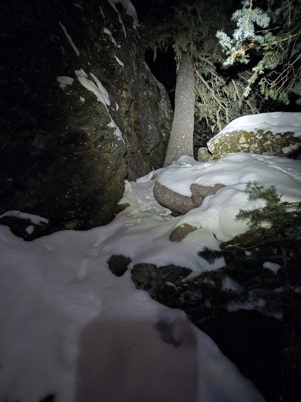
After this, the route starts getting more interesting. The trail becomes harder to follow, unless you're lucky enough to follow tracks of someone who knows where they're going. You'll encounter some slabs to scramble up - microspikes are highly recommended here. Later, as you cross a frozen pond, you'll want to cut to the left at the far side and find a weakness in the willows that goes under some cliffs/boulders on your left then up a steep but short snow covered hill that bypasses tricker slabs that are off to the right. At around 4.2mi you'll run into some cliffs with a waterfall that's likely to still be flowing. Follow a path bashed through the willows to the base of the falls and then go up a rock chimney that's maybe 20ish feet high? Swing around a large rock on the right near the top and up some steep slopes in between pine trees until the ground levels out and you'll catch your first views of the Crestones - if there's enough light you'll be able to see the most likely snow filled Red Gully to your left and Needle off to the right. Pick the best path up over rolling hills and around/over willows. There are a few cairns here and there but you may have to wing it. The goal - regardless of whether you're going for Peak or Needle, is to keep going up the valley until you intersect the summer trail for Crestone Peak. At that point you turn left for Crestone Peak and follow the summer trail from there or turn right and follow the summer trail for CP in reverse until you top out on Broken Hand Pass and then follow the standard summer trail for Crestone Needle The Gullies: For either Crestone Peak or Needle, you'll most likely be going up a snow filled gully. For either case, you'll soon be dead and buried if avalanche conditions aren't really super safe. You might have some chance of going up rock next to the gully for Crestone Peak but, at least when I was there, it was pretty filled in and would be most likely class 5 to bypass the snow. Crestone Needle had better odds when I was there of staying out of the snow but requires class 4 and likely class 5 if you wanted to try to avoid all snow. In both cases, I strongly recommend mountaineering boots and real crampons. Some may think that's overkill, but if you ask my advice, that's what I'll give (read Section V: Threading the Needle - Crestone Needle Successful Summit from Cottonwood Creek; if you want to see some justification for why I make that recommendation - if something goes wrong, you might really regret using some half-ass footwear/traction). Also bring spare gloves!!! You might find it hard to keep your hands out of the snow for some sections and you can get frostbite through your gloves if you do that too much when temperatures are low - ask me how I know...) Make sure you have an ice axe and know how to self-arrest!!! These gullies get pretty steep in places and if you find really hard snow you may need those self-arrest skills. Lastly, for Crestone Needle in particular, many people screw up the descent and get cliffed out. I managed to even screw up the ascent (Section V) and almost cliffed out then. I strongly advise downloading GPX tracks and checking them periodically. I'm including my GPX tracks for Crestone Peak but not for Needle since I botched the route so bad. Please just use the GPX provided for the approach then use the standard summer Crestone Peak GPX on this site to BHP then the standard summer GPX for Needle from there to the summit. 14ers Mario Kart profile graphs This is mostly a just for fun interlude where I got to pondering what it would be like if the various folks on the forum were Mario Kart figures and you ranked people by their stats for various abilities similar to how in the popular game Mario Kart (which I used to play with my nephews) it gives charts for speed, etc for the different Karts. I say mostly just for fun because in real life it does sort of help to know the "stats" of potential partners and how your strengths and weaknesses do or don't play well together. 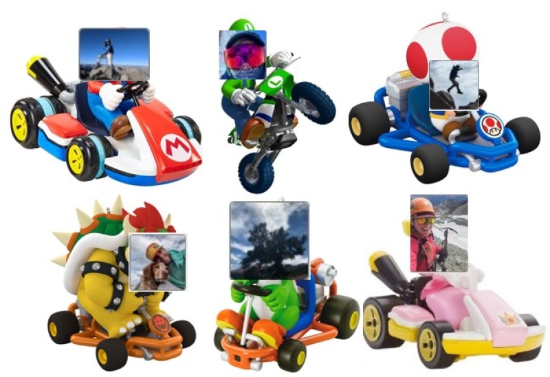
To belabor the analogy just a little bit longer, I got to thinking about what sorts of general categories people fall into, especially in regards to winter mountain climbing where some additional factors come into play. Here's a nerd's look at some categories. 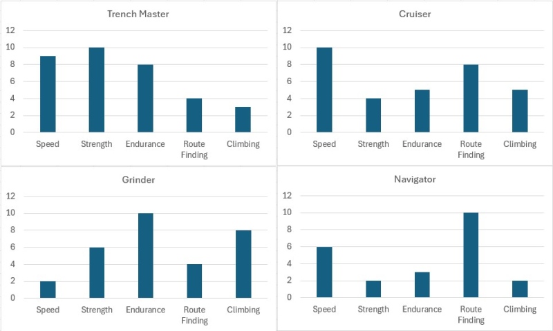
Trench Master: These are the folks with both the speed and the strength to plow through deep snow like it was nothing. They may or may not be good route-finders as well because they may or may not need to really care too much since they can just bash ahead to the right location. Cruiser: These are folks who are good at finding the route and blasting along it and who do great in summer but might not have the strength and endurance to excel with trenching in deep snow - they do much better if someone else puts in a trench first. Grinder: These are people who aren't especially fast and might not always be the best at finding the right route but they can keep grinding on all day long (I kind of graphed out my perception of myself here after finishing my 24hr+ Needle climb) Navigator: These are people who are fantastic at picking out the right path and are decent enough with speed if they have a broken trail but may really struggle with deep trenching if solo. All of these graphs are random and imaginary, though I could think of various folks who more or less fit one category or another. But it might be a useful exercise to graph yourself when considering your goals and ask if maybe you need to try to make friends with a Trench Master to plow the route, a Navigator to keep you on course, a Cruiser who can go for help if needed or a Grinder to come up the rear and make sure the return path is stomped down flat for an easy exit. Or alternately, plot out your strengths and weaknesses and then see if you can "level up" your character - like I'll be trying to level up mine... The Journeys Now for the full story-telling recounting of taking on these peaks. Curl up on the couch with your warmest blanket and hot beverage of choice - you're going to get cold just reading about this! Section I: Crestone Peak Attempt from Cottonwood Creek Date of climb: Saturday December 21, 2024 It was 8:48pm on Friday December 20, 2024 - the night before the winter solstice. Per the rules established by community consensus, I couldn't start the hike prior to 2:19am on Saturday in order to get credit for a snowflake. So I buried myself in a zero degree sleeping bag in the back of my 4Runner at Cottonwood Creek Trailhead as all the warmth inside the vehicle slowly seeped out into the cold abyss outside. All my hiking gear, except for my boots, was already on so that I wouldn't have to change clothes in the bitter cold of the pre-dawn morning hours. There was one other vehicle at the trailhead in which I assumed was buried another would-be snowflaker, though it turns out the occupants of that vehicle returned later than night. But no matter, it sounded like they came down the trail I would be taking, so I was glad to have someone refresh the tracks that bigfoot1 has posted about making the week prior. Upon awaking from far less sleeping than I had hoped for, my body had no desire to emerge from the warmth of the 15lbs sleeping bag it was buried in. I took my time eating my Pop Tarts and peanut butter crackers and was happy to see I had just enough signal to complete my daily Duolingo lesson at 2:29am, keeping my streak alive and helping to ensure I didn't start on the trail too early. But I still needed to pull out the Jetboil and boil some of the water that I had stashed in my sleeping bag to keep it from freezing in order to make some hot apple cider that I hoped to enjoy on the summit. It was 3:12am by the time I finally hit the trail - well past the official solstice - but long before sunrise. The trail goes up a valley through which the stream was still running with exposed water, despite temperatures being well below freezing. Anyone who has hiked near a flowing stream before sunrise knows the bitter chill it adds to the air. The cold was so all piercing this morning that the normal technique of just warming up by hiking wasn't working. Before long I had added nearly every layer I had and was still struggling to stay warm even moving as fast as I could. The first couple of miles went fairly quick and easy but then came the first of the ice - and soon large sheets of ice coating entire hillsides! I had to stop once again to put on spikes and grab an ice axe. Each time I came to a full stop, sacrificing the generation of precious body heat. It was starting to get light by this point but due to being down in a valley, I would not feel the warmth of the first rays of the sun until 8:49am. Yes, I know the exact minute those first rays of life saving warmth hit. I can't remember ever watching with greater anticipation for the warmth of a ray of sun! 
The difference that the sunlight made that day was shocking. In a short period of time I went from struggling to stay warm to massively overheating. I stripped enough layers to expose some bare skin and flush away the sweat before it could become a greater problem, then re-layered in a more conservative fashion. Before long I was faced with obstacles that I failed to properly research beforehand - cliffs and waterfalls and rock slabs spread out across the valley. I suddenly realized I had no clue how exactly to get beyond these obstacles, and they didn't look very inviting in winter. I ended up being lured up a small, snowy couloir to my left in the hopes of getting up onto some dry-ish looking rock and hopefully past the difficulties. But in the end all I did was add a lot of extra effort to gain elevation that I was forced to immediately surrender on the other side of the rocks that turned out to only drop down in front of the difficulties I had seen. So I was forced to slowly approach the challenges ahead and eventually blundered my way up a haphazard path of snow covered slabs. The exact path I took that day is a bit of a blur now after the many treks up that valley. Suffice it say that on later trips I was able to take a more refined version of that route I blundered through that day. 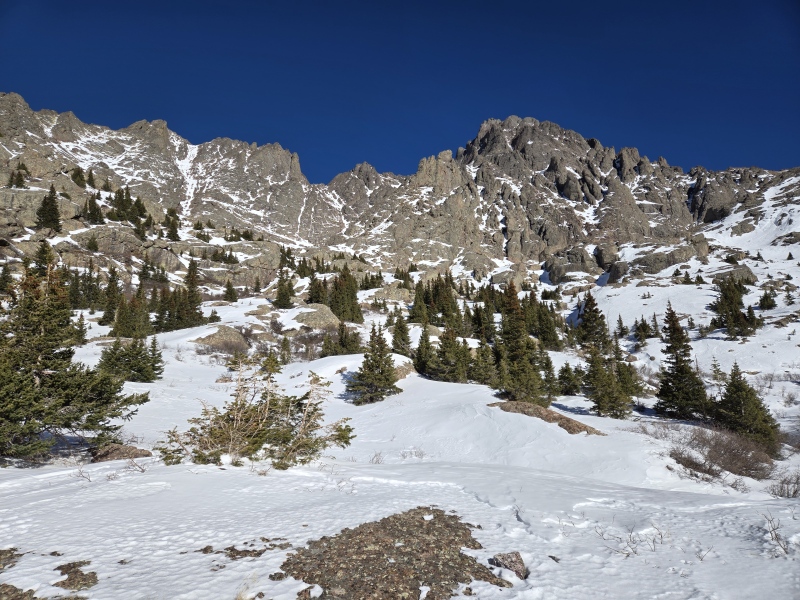
Upon finally getting up to where I could catch the first views of the Red Gully, I had already exhausted myself - having not been at all prepared mentally or physically for all the route-finding and scrambling this earlier in the hike. I was about to give up for the day when I heard someone approach from behind. It was bigfoot1 (Emily) who had attempted the route the week before and posted a conditions update. After a short chat, Emily took the lead and started plowing ahead through the snow with periodic curses as the snow would go from a firm crunch to suddenly a knee-deep plunge among the willows. I grinned and followed, happy to have someone else take over the cursed job of cursing the willows. Soon Emily started to get smaller and smaller, despite being the one doing the hard work of trail-breaking. The lingering remnants of chauvinism in me whispered "dang, I just got chic-ed!" But the motivational power of knowing someone else is busting through the hard work helped reinvigorate me and I eventually caught up to Emily at the base of the Red Gully. 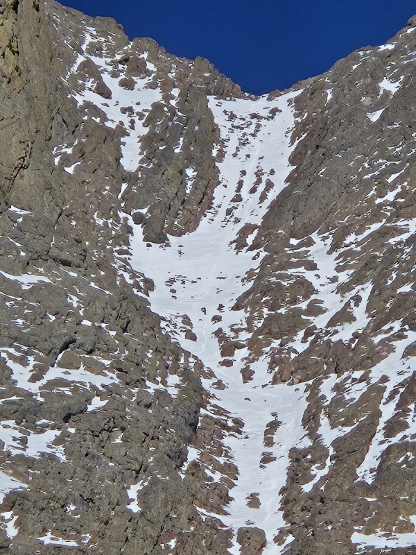
We had noticed that even from a distance we could see tracks going up the Red Gully. That meant someone, at least, seems to have made it to the top. But we were both acutely aware that just because a slope already has tracks on it, that doesn't mean it's safe in terms of avalanche danger. The CAIC forecast for the day was green on all aspects and elevations, with no avy problems listed, but the sun was shockingly warm that day - enough so to make us both uneasy about what effect that might have on the steep snow. Besides, we had both burned a great deal of energy just getting to that point and Emily decided she wasn't comfortable with her selection of gear after having laid eyes on the Red Gully. So we finally both decided not to try that gully under the hot sun after having gotten tired just on the approach. Emily soon blasted out of site, as I slowly plodded back to the trailhead, but was happy that Emily had avoided some of my worst route choices and left tracks to follow a better return path. Section II: Crestone Peak Successful Summit from Cottonwood Creek Date of climb: Thursday December 26, 2024 Christmas Day, 2024. It was a smaller gathering for Christmas this year and so, without the nephews or other out of town relatives visiting, after we finished all the typical Christmas activities, I loaded up the 4Runner for the 4.5hr drive to Cottonwood Creek Trailhead. This time I didn't get settled into the back of the 4Runner until 9:51pm. As a result, and hoping to have better sleep than for the last attempt, I set my alarm for 3am. By the time I extracted myself from the sleeping bag, boiled water for some hot cocoa, etc, it was 4:04am when I finally hit the trail. A couple guys had shown up and left from the trailhead while I was getting ready. Having gotten much better sleep this time than last, I was moving at a much better pace and eventually overtook them. Turned out it was Luis (grizel) who I had hiked with on a trip I led up Massive, and another guy named Mike. We played leapfrog for a while as I periodically stopped to put on microspikes or switch to snowshoes. This day the first rays of sun hit me at 8:53am by which time I was already nearly at the base of the Red Gully. 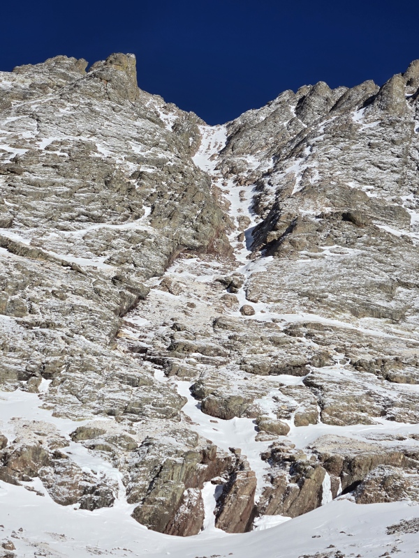
I made it all the way up to the Red Gully that day without needing to use my snowshoes. Mike overtook me as I paused to switch to crampons and let me know that Luis wasn't feeling it and had bailed. Despite the fact that I was moving a lot faster today than last time, Mike proceeded to confirm for me that I am not a Trench Master as he powered up the Red Gully, blasting in footholds up ahead of me - for which I am immensely grateful! 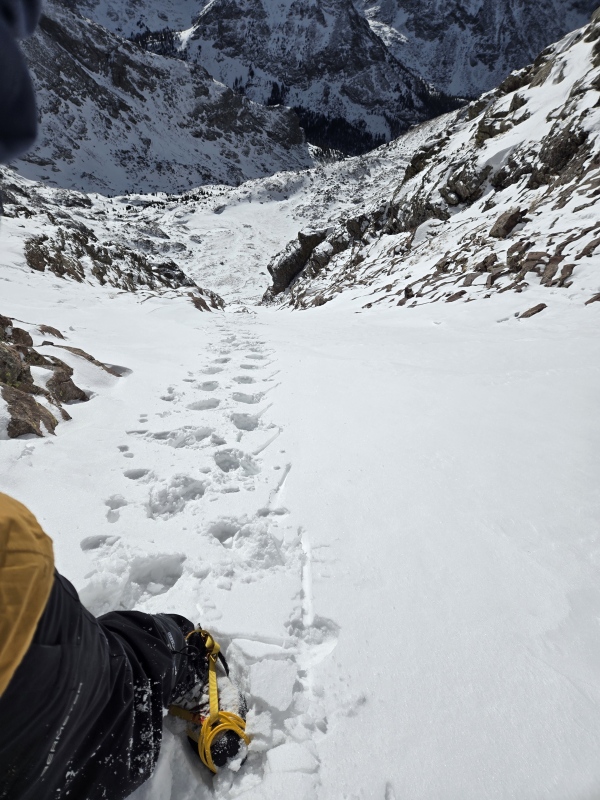


However, even with someone else setting good tracks to follow, it was still far from trivial going up that gully. Even in summertime this gully feels like it goes on forever (my friend Geo who finished the 14ers on Crestone Peak still sometimes jokes that everything since that time has just been a delusion and we're in fact still climbing up that Red Gully - it's an argument that I've been unable to compellingly refute...) Anyways, Mike had already summitted and was heading back down as I got to the saddle. 
I was looking down into the valley with a mix of awe and unease as Mike dropped back down to my position... 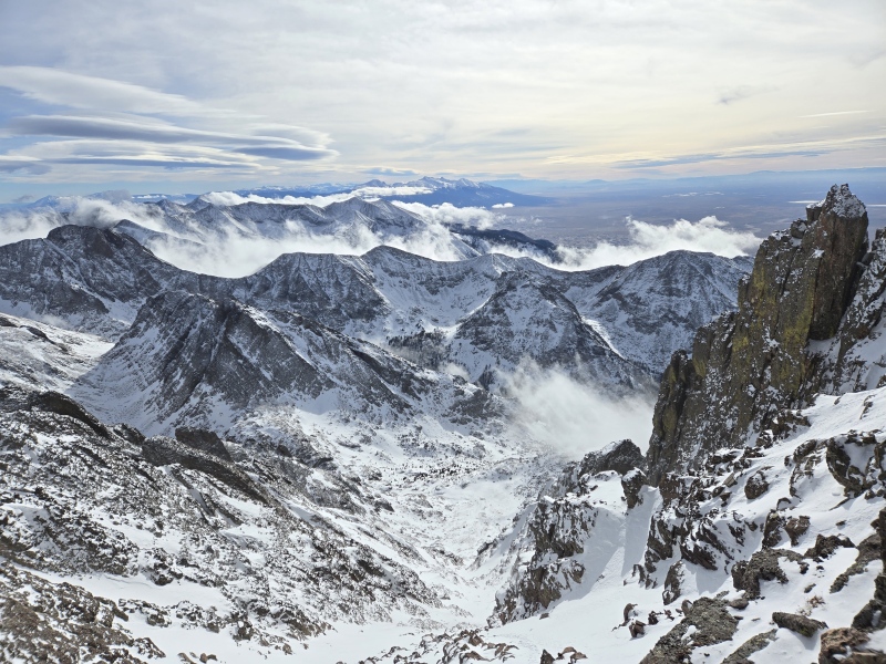
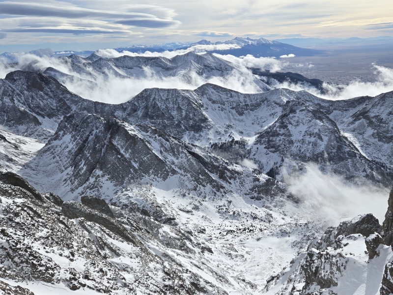
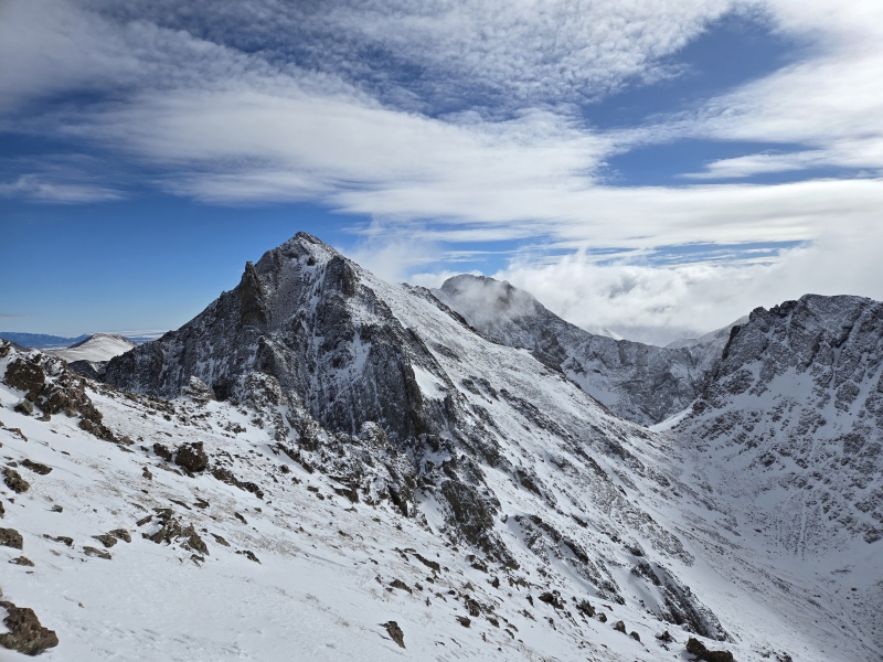
There were clouds starting to slowly fill the valley below. I've seen this effect a time or two before - most notably on Longs peak where clouds filled the valley and then slowly rose to cover the mountains. So I was a little uneasy about being up this high as the clouds rolled in, but I was way too close to the summit to quit. Mike briefly chatted with me and assured me that I could easily tag the summit but agreed that I should then waste no time in getting down. Tag the summit I did indeed - and what a cool summit in winter! I had originally planned to summit nearby NE Crestone and East Crestone that day as well, but besides the concerning clouds showing up below, the wind just past the saddle was roaring like a jet engine so I figured I would be ripped off the mountain if I tried to go over to my favorite 14er sub-summit. Besides, I was starting to feel fatigue already and knew that adding some scrambly summits might push me too far. 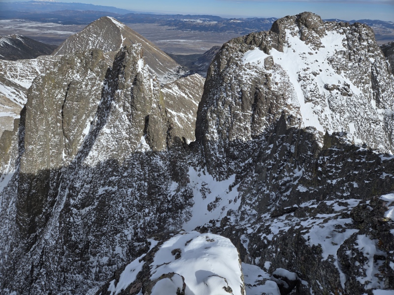
I paused long enough to get some photos of the surrounding area, including the famous Kit Carson Avenue on that nearby 14er. 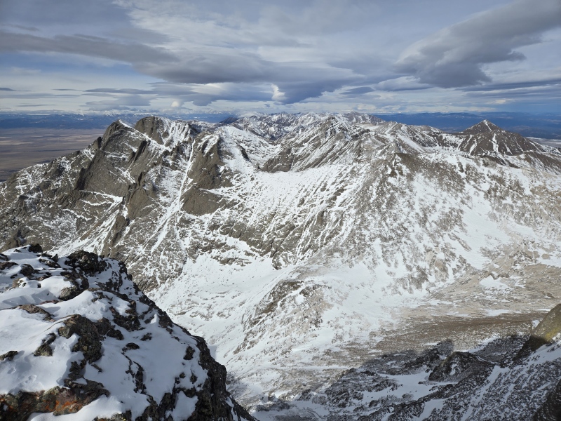
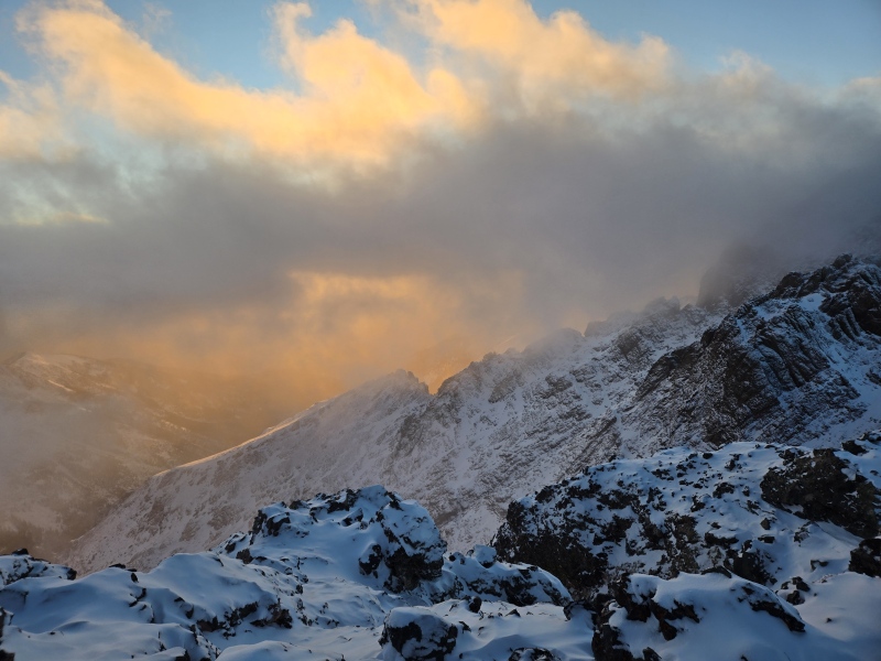
After getting the photos, I wasted no time in getting back down. The foreboding clouds below never did turn into anything menacing, but given the insane winds blasting the nearby sub-summits, I still think I made the right choice to descend without flaking them. Going down the Red Gully took forever, especially since I wasn't feeling confident enough to try glissading, especially up near the top. I had neglected to do my annual field refresh of self-arrest practice and so just wasn't feeling safe letting it rip on such steep snow of highly variable quality - some places you could sink a good bit, others that were bulletproof. As a result, I burned a lot of daylight slowly trekking back down the gully. But the upside was I later got some nice sunset shots on the way back to the trailhead! 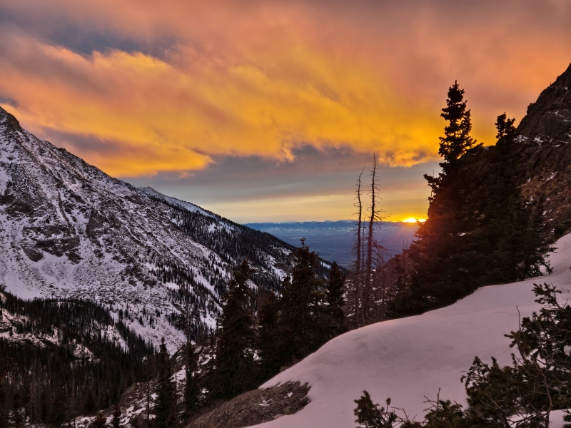
Despite having moved relatively quick on the way up (I had left the trailhead almost an hour later than the previous time but was already on the summit by the time I had previously only made it to the base of the Red Gully) I was not able to maintain that speed on the way out - I think in large part because of the slow punishing descent out of the Red Gully. I did eventually get some glissading practice on lower angle terrain but had already burned a lot of energy by then. I'm usually much faster on the return but not this time. I didn't reach the trailhead until around 8pm - my phone battery died maybe 30 minutes or so out from the trailhead and I didn't feel like pausing to take off my pack and pull out my battery pack. Section III: Crestone Needle Attempt from South Colony Lakes Date of climb: Saturday December 28, 2024 You'll note this climb is dated only 2 days after the successful summit of Crestone Peak, but is now on the opposite side of the mountains, coming in from the east (Westcliffe side) from South Colony Lakes. This is because I assumed big back to back days would be too much and, after doing 2 hikes from Cottonwood Creek Trailhead I wasn't really feeling like hitting that long approach a 3rd time in a row. Besides, I was also planning originally to go tag a comparatively easy 13er that Will_E and others had already nicely trenched. But after getting a hotel in Salida with a hot tub and relaxing all day Friday, I felt like I could maybe take on Needle. NOAA was calling for annoying but not horrible wind gusts up to 30mph. OpenSnow though was calling for gusts in the 60-70mph range. I decided to take a chance on the NOAA forecast and also take a chance that the old 4WD road to South Colony Lakes would be trenched out. Plus, taking a queue from my later start on the successful summit day of Crestone Peak, I decided to start even later for Needle to allow for more sleep and less bitter cold. I started from the 2WD TH at 4:52am. Within the first half mile I could see evidence of vehicles that tried to get up the road but couldn't. 
But indeed, the old road to SCL was tracked out by some manner of snowmobiles or such. This made moving along very efficient, for a winter trail. 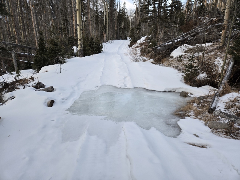
But alas, OpenSnow won the battle of the wind forecast - even down low the wind was killer. It wasn't even so much the force of the wind but the fierce, bitter intensity of the wind chill. I thought I had worked out a pretty good layering scheme over several previous winters but this wind was piercing right through multiple layers of Merino wool, Gore-Tex, etc as if it was nothing - and this was still down below treeline!!! This was going to be a no-go. I was totally discouraged and ready to give up. Just then TobyMac showed up. Any fellow church-goer familiar with the Contemporary Christian Music scene (CCM) will appreciate how impressive it is to have TobyMac join you on a hike (while folks not familiar with that genre will probably be like "Toby who??"). That was just the motivation I needed to turn the day around. With Toby by my side, I started pulling out backup layers and improvised a way to cover my face without fogging my glasses (a perpetual problem for near-sighted mountain climbers in winter). I had on my Eskimo hat for extra warmth, a Gore Windstopper neck gaiter pulled up over my nose and under my goggles but left the top of my jackets unzipped to not bounce the air I breathed out back to my face. Then I finished with my signature scarf wrapped around below to help keep the heat in and the wind out. It worked!! Once I got moving, I was generating enough heat that it didn't matter that the lower half of my face only had the somewhat thin neck gaiter over it - that was enough to eliminate the bite of the wind, while the extra nearby layering compensated for the heat loss without trapping heat in such as way as to fog my glasses! Success! Now me and Toby were charging ahead full steam together (ok, ok, Toby wasn't actually there on the trail, but I put his song, The Elements - see partial lyrics right below the first photo of the report - on loop and powered up the trail). 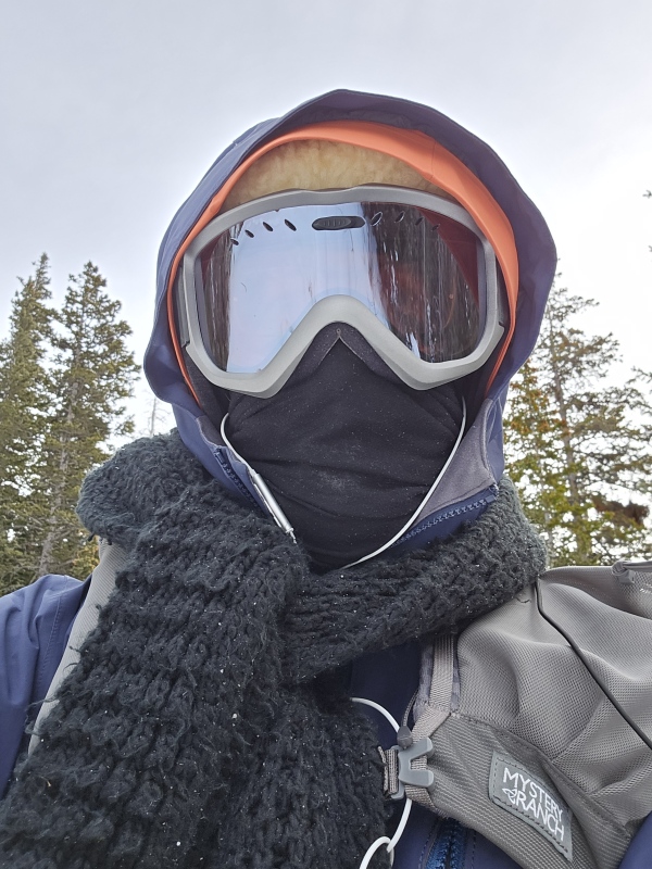
This setup was so incredibly successful at warming me up that, together with the large burst of speed I broke out, I probably shouldn't have been surprised that I flipped the tables too far and starting sweating heavily. Oops. Stop, find some pseudo-shelter, strip off layers and blow away the sweat. I was perhaps a little too pumped at this point (it's Toby's fault...) so I actually ended up bare-chested and stepped out into the wind to thump my chest at it (only possible in that weather because of the immense body heat I had built up with all the layering and the heavy exertion). With all the sweat dissipated in the first couple of microseconds, I soon decided that was quite enough chest thumping and quickly shook out the layers I had carefully secured against the wind and then got dressed - with no longer a drop of sweat anywhere to be found. 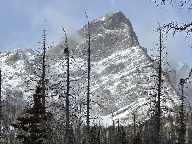
Being fully invigorated and de-sweated (is that a word??) I now continued on at a more measured pace, keeping better track of my body temperature and adjusting pace and/or zips to maintain a stable body temp that was neither too hot nor too cold (which is what I should have been careful to do from the start, but I think this was a negative double-digit wind chill kind of day - at least up at the summit - and so it was pushing my normal setup past its breaking point). Eventually the old 4WD road snowmobile tracks ran out. The summer trail was covered with huge drifts and when I tried to trench out a shortcut, I quickly sank waist deep not far from where I knew there was a stream because I had crossed the downstream version at a place with exposed, running water. Not wanting to take a swim in that weather, I backed up and found the sign pointing out the trail to the far side of Humboldt, which would also serve well to get to Broken Hand Pass. The trenching and route-finding through the trees was tough but not altogether horrible since I had done that route in the past year and could kind of pick out the way. Finally, by the time 1pm arrived, I was still only at about 11,500ft and had plenty more trenching to do just to get to BHP - not to mention going up the gully from there and hiking all the way back. My late start plus all the time lost in dealing with layers and trenching the wrong path, then the right one, etc was just too much. Plus, looking up, I could see the wind on Needle was absolutely ridiculous. Even if I did make it up there I would get blown off. 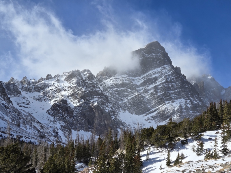
So despite all the chest thumping and all the help from Toby (I think I left The Elements on loop for at least a couple hours...), in the end the wind won the day and I decided to retreat while I still had time to comfortably make the 4.5hr drive back to Fort Collins. 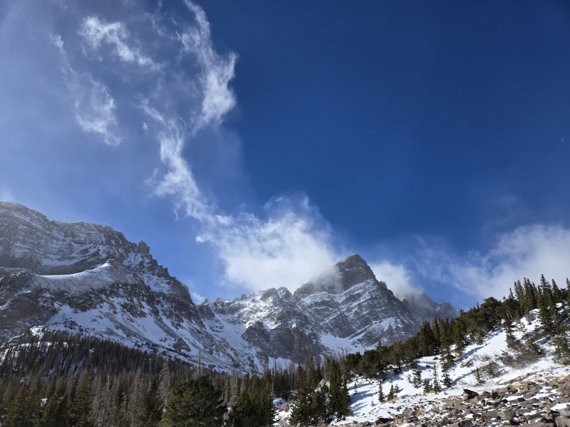
Section IV: Crestone Needle Attempt from Cottonwood Creek Date of climb: Wednesday January 8, 2025 After the last attempt from South Colony Lakes, I took some time to analyze my tracks from that attempt and from doing Crestone Peak and realized that I had gotten much closer to Broken Hand Pass when doing CP than when I tried to get there from SCL. So this time I made the wise decision to approach from Cottonwood Creek again and picked a Wednesday where the wind wasn't too terrible to try it. But foolishly, I thought I could work on Tuesday, slipping out a bit early to drive to the trailhead, then climb Needle on Wednesday and get back to FTC in time to go to work at 8am on Thursday... Bad plan. That did not work... at all. This time I started at 4:47am (using the better sleep = better hike theory). Below is an excerpt from my Conditions Report from that day: "Started solo in bitter cold with enough fresh snow to cover all previous footprints. Trail was still easy to follow except a couple spots where the new snow made me briefly lose the trail. Also some areas with boulders and fallen trees that filled in just enough to hide trap doors. This all contributed to making me much slower than when I did this same approach for Crestone Peak. Bigfoot overtook me at Cottonwood Lake and led the charge up to BHP." We made the mistake of going up to the pass in snowshoes because it seemed like the snow was deep enough to need them (on the way down I discovered that microspikes were actually preferable because it was generally not all that deep and/or was firm enough that snowshoes weren't needed). I was glad that Emily had arrived and joined up just in time to put in tracks up to BHP. I grinned again as the periodic cursing alerted me to the places that Emily's snowshoes were not getting enough purchase to prevent slipping, despite having ascent bars up - once again happy to have someone doing some of the hard work and not feeling bad that I couldn't keep up. By the time we got to the top of Broken Hand Pass, it had been another butt-kicker of a day and the wind was really, really annoyingly strong. Emily had had enough and decided to bail, while I used the new layering configuration I had developed on the other side of the mountain a week or so before and decided to press on. 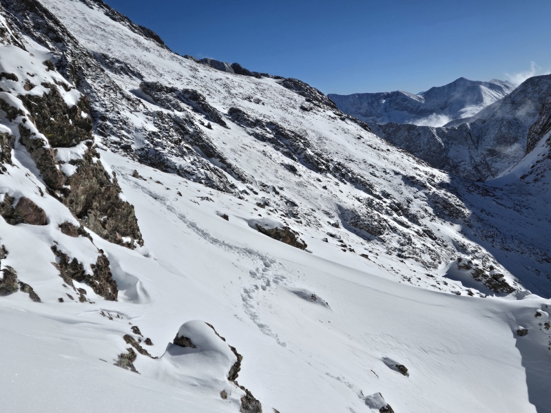
But I had forgotten the way the summer trail dips so far down below the ridge. Even though the avy danger was still low (and had been for most of the last month or so), I was still nervous about being out on such steep slopes, especially when I could sometimes walk on top in boots and then suddenly punch down knee-deep or more. So I tried to get up higher and do more scrambling but that only burned a lot of time and energy only to leave me still ending up in places where I had to cross some steep slopes anyways. 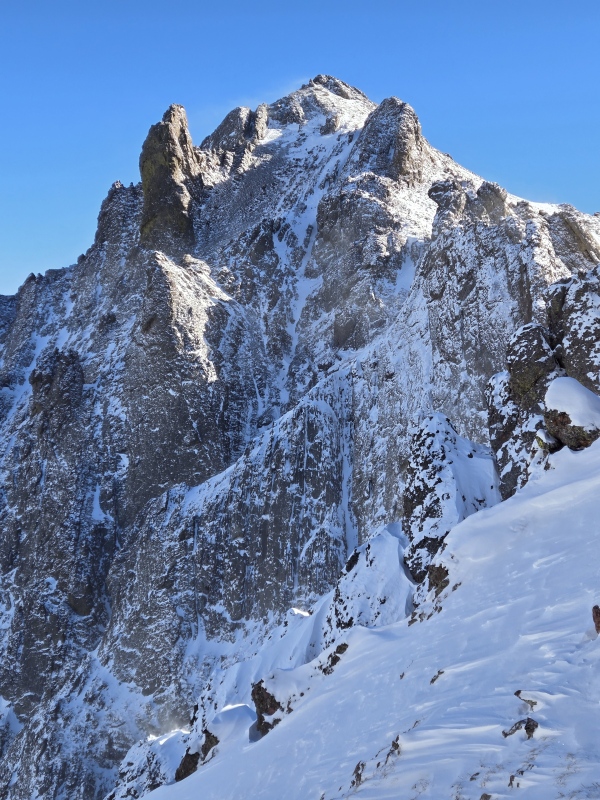
At one point, as I was coming around some rocks, I smacked my thigh on a slab of snow so stiff that it felt like rock. I gently tapped it with my foot and discovered there was a slab several inches thick, but when I kicked below that it was just loose fluff. This made me rather nervous. Seeing how much time and energy I was wasting just trying to get to the base of the gully, I knew it was going to take far longer to get up and back down the gully. Plus I still had to make the 4.5hr drive back to Fort Collins so I could be at work at 8am the next day. Well this was a stupid plan. Who's idea was this?!? Given the constraints, I decided against pushing on and instead opted to try to get back at an early enough hour to actually get some sleep before going to work the next day. I took a few reference photos on the way out. There was one spot where I was a little nervous about the snow slope. My footprints poked deeper there than some of the other sections as I had come across it. Avy danger was very low but it still gave me pause. So I decided to go up to the very top of the snow slope where I could hold onto rock as I passed along over it. I get up to the top and grab onto a sturdy chunk of Crestone conglomerate and then take the first step out onto the top of the steep snow slope... A deafening roar fills the air. Oh my goodness - I never suspected an avalanche would sound this loud!!! But wait, nothing is moving... Holy smokes, that not an avalanche, that's the wind ripping over Broken Hand Pass! I'm going to be ripped off the mountain when I get over there!!! Then I look up just in time to see a fighter jet buzzing BHP - it seemed like it couldn't have been more than hardly 100ft over the pass. If I was not so horrified by the timing I would have been amazed by the up close view of a fighter jet out in the mountains... I continued across the slope without incident and then back down the pass. 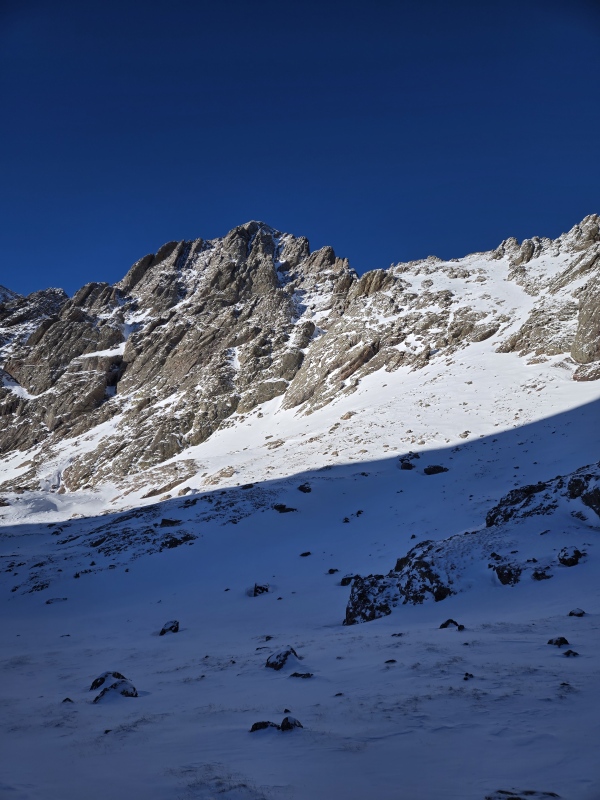
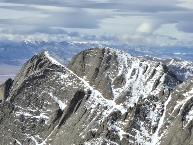
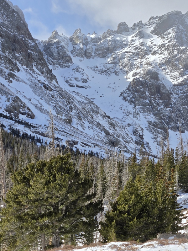
Before concluding the write-up for this second unsuccessful Crestone Needle attempt I'll pause to give some ominous foreboding of what's to come in the next section... In the photo below you'll see a zoomed in shot of the East Gully in the middle of the image. On the left side of the image is the West Gully. Follow it down to where the snow thins out and you'll be at the point of the former cross-over to the 3rd class route that used to be the standard summer route. Continue to sweep your gaze across from there to the right side of the photo. You'll note a large V-notch in the ridge. Return your gaze to the East Gully running up the center of the photo. Notice how it goes up and curves to the right before gaining the ridge at a location where you have to walk up a ways before reaching the summit. Now move your eyes to the bottom of the photo. Drop in fresh snow to cover more of the rocks. Move the sun far to the left, dropping the entire region into shadows. Move in low hanging clouds and a light snowstorm to limit visibility... Now track your eyes up and notice how the gully goes up and curves to the right before gaining the ridge at a location where you have to... walk up a ways before reaching the summit... (keep in mind the growing shadows, low clouds and light snow limiting visibility and growing fatigue from an already long day that began with limited sleep). Now you've reached the top of the... oh crap!!! (To be continued...) 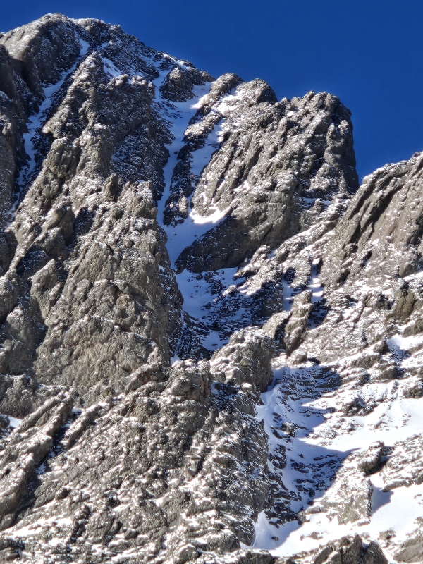
Section V: Threading the Needle - Crestone Needle Successful Summit from Cottonwood Creek Date of climb: Tuesday January 14 - Wednesday January 15 I want to preface this final chapter by pointing out some of the precautions I took based on the previous expeditions. With all the foreshadowing in the final paragraph of the previous section and all the blunders I've mentioned on and off throughout the report, it might be easy to get the impression that I'm highly reckless and careless in my decision making. While far from perfect, I do make a lot of effort to be safe in the mountains and always encourage others to take all possible precautions. So before I proceed to tell you how badly I nearly screwed this all up, let me balance that with some of the things I did right, which demonstrate I was at least attempting to avoid a lot of common issues. I had already learned that this route starts out in a wickedly cold valley with a stream running through it. I had already learned that the temperature swings this time of year after you hit direct sunlight can be large. As a result, I had come better prepared to deal with the temperature fluctuations. I had already dialed in my layering system to deal with negative double digit wind chills, which I knew I was likely to again face at least on the ridge, if not before - though with winds not as strong as before. I had already been working on increasing my overall level of fitness to handle big days like this (to the extent possible in a short time frame). I had already been paying extensive, excruciating attention to some last minute changes in the avy forecast (see Avalanche Danger and Weather section above) and had decided it was ok to continue. I had already learned my lesson on leaving too little buffer room before/after a trip - this time giving myself 3 days off work to tackle just one peak and getting a hotel 18 minutes from the trailhead in order to hopefully help deal with the sleep issues. I literally took this effort to the Fifth Dimension in order to give myself every possibility of success (Bliss Inn in Crestone has a room named the Fifth Dimension - great little base camp!) 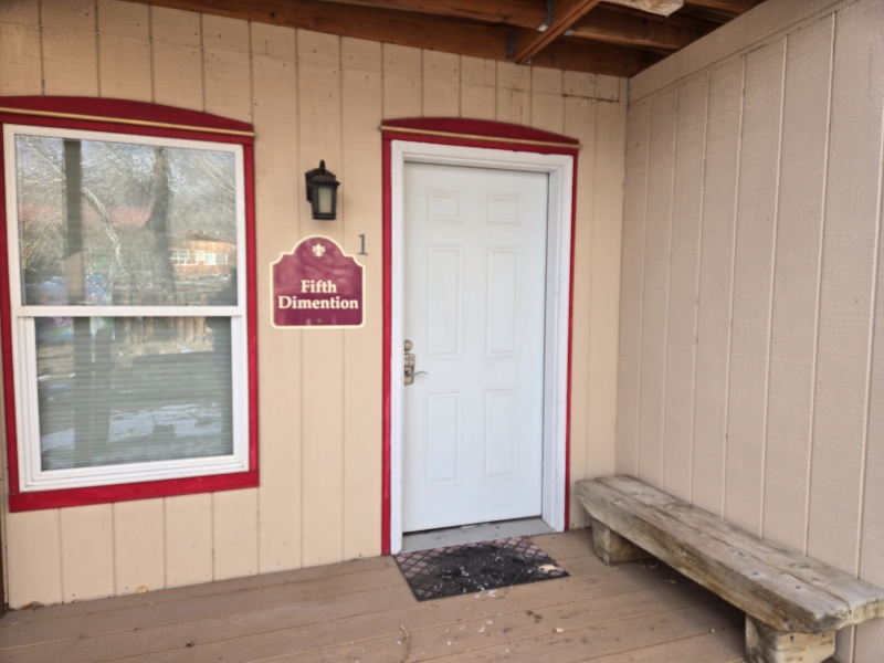
In addition to all this, I used my Scheels gift cards from Christmas, along with additional funds and went to town on stocking up on the best gear. I replaced my old emergency puffy that was too small and had spent too much time squished in a pack. It's replacement was an XL with better zipper system and some inside pockets along with a very useful chest pocket on the outside. I got a balaclava with an exo-hinge to swing the mouth covering out of the way to deal with fogging of glasses. Also picked up a Merino wool neck gaiter, brand new liner and mid-weight gloves, etc. I was now stocked up with all the right gear to extend my safety margins by keeping me warm even during a bitter cold start and when dealing with negative double digit wind chills up high. This day's forecast was going to be the coldest yet, but I was counting on the extreme cold to help freeze the steep snow in place and had extra layers to deal with it. I paid attention to every last little detail that could improve my success... well, almost. Nobody's perfect. It's the small assumptions and the little oversights that can get you killed. Thankfully that didn't happen this time, but my safety margins got cut way too thin before the day was over. In the end, I lived to be reminded how those small errors can turn big really fast. This recounting will therefore hopefully both entertain and inform as I try to give a vivid recounting of what went wrong and right - and since this was a more than a 24hr endeavor I shall begin with... Hour 0 Tuesday 2:08am; start hiking from Cottonwood Creek Trailhead. 4th time on this trail since late December. Needed more buffer time at the end of the day so I started nearly 3 hours earlier than the previous time. Had hoped that driving down on Monday and spending the night in a hotel would eliminate the issue of limited sleep. But for whatever reason - maybe nerves, etc - it didn't. While I rested in bed for a full 8 hours, I probably only got 2-3 hours of actual sleep. Not the start that I had wanted, but hopefully the multiple hours of rest will supplement the actual sleep... Also, just had fresh snow but extremely inconsistent around the region - some areas nothing, some a dusting, some 6 inches or more. Hour 1 Overprepared for the brutal forecast - sub-zero high on the summit, never above freezing at any elevation at any point of the day. Started too warm again, though corrected more quickly before getting sweaty. Occasional small breeze makes big difference in temperature. Normal pit zip, leg vents, etc adjusting is inadequate to control temperature. Loose time and energy stopping to swap layers. Inconsistent snowfall is apparent along the trail - some areas almost no new snow since last time, other areas 6 inches or more. This contributes to some slight slowdowns to not lose the trail, but by this point pretty familiar with the problem spots. Put snowshoes on earlier this time to deal with trapdoors. Hour 5 7:48am topped out on the waterfall climb for which I left my snowshoes on in the hopes of loosing less time with gear transitions since I was already moving slower than desired (more than an hour and a half behind the pace of my successful Crestone Peak summit). Scaling the chimney in snowshoes was a little awkward but worked fine and I think it did save time. Hour 7 9:28am Cottonwood Lake. Now running roughly 2 hours behind my pace from when I summitted Crestone Peak, but since I started that much ahead of the start time on that trip, I was not yet overly worried about the slow pace. Slow and steady wins the race. Hour 9 11:17am On top of Broken Hand Pass. Had already switched to crampons before starting up the pass and already had face coverings and other wind gear on, ready for the expected increase in wind on the ridge, but forecast for lower winds proves correct and I'm actually able to vent my layers to keep a stable temperature rather than needing to seal everything up. I left my snowshoes by a rock at the bottom of the pass, banking on not needing them based on my experience from the previous attempt. I knew the weight savings would be well worth an occasional post-hole. Beautiful blue skies, minimal wind. Perfect winter day. Feeling strong, alert and encouraged. 
Hour 10 High noon. 13,000ft. Getting enveloped in fog/clouds. There are no storms forecast for the day by any of the weather sources. It will lift. I'll be fine. 
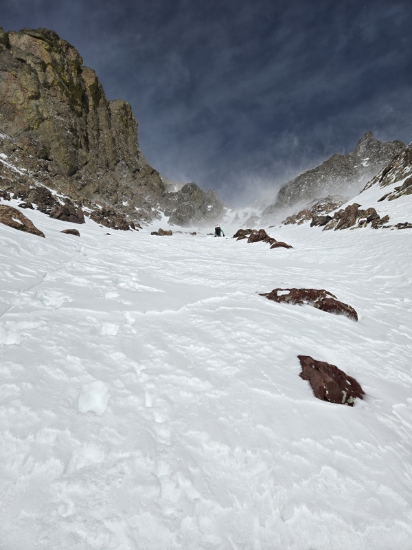
Hour 11 1:30pm Took a long break at the base of the East Gully to rest and fuel up. Visibility remains patchy and inconsistent. Check GPS to confirm entry point to the gully matches previous tracks. Occasional light snow, sometimes the clouds break. Hard part of the navigation is over - going up will be easy; will just need to be careful on the descent to drop into the proper gully... Nothing left now but a long grind up the gully to the ridge. Time to settle in for the long, dull push to the ridge, then short walk up to the summit. Engage auto-pilot. Hour 12 2pm Switched out of crampons and into microspikes since the snow quality is inconsistent and going up along the rocks next to the gully seems more efficient - but crampons are too awkward on rocks, thus the switch to spikes. Take one more look at the GPS and previous photos - gully goes up with slight gradual veering to the right. Visibility patchy but ok - see gully veering to the right with ridgeline up above. Push on. This is getting really tiring. I already feel like I've been in this gully forever. Climbing is becoming more difficult. I'm ending up with arms and legs spread out in funky positions to get the best holds amidst the snow and occasional bits of ice. This is starting to feel harder than class 4... maybe I should double check my GPS... but my hands aren't exactly free at the moment - and a quick upward glimpse tells me I'm nearing the ridge. Focusing strongly on my holds now - just need to push up this last bit. Must have veered slightly off route onto some class 5 but just need to hit that ridge and walk up to the summit and I'll be fine. Can look for the easier route on the way down. Just watch those holds - a few more tricky moves and I'm home free... 
Hour 13 3pm Finally reached the ridgeline as the clouds in front clear out but... wow, what a heck of a view! Why don't I remember a view like this from the last time? Well, I just have to walk up the... oh crap!!! Where the heck did that come from?! That's not a walk-up - that's beyond class 4, probably at least mid 5th class!! What the heck, what the heck?!? I pull out my GPS to check the elevation - oh no way, you've got to be kidding!!! Only 13,600ft?!?!? No, no, no, no, noooooo!!!! Oh crap, oh crap! 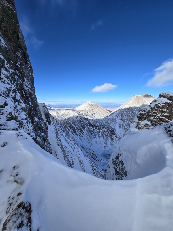
I look back down what I had come up to get to this spot and get a sick feeling in my stomach - I think I might have already violated one of the number one rules of climbing: "Don't climb up what you can't climb down" and vice versa. I thought I was ok not worrying too much about what I was coming up because I was so sure I was close to the easy top of the ridge where I could stroll to the summit and then just reposition the descent slightly to end up in easier terrain on the way down. Now I was in a spot where I couldn't safely go up and I was extremely uncertain about downclimbing what I had just come up. I'm not making the summit today. Damn. I might have trouble even getting out of here. This is bad. Really, really bad. This is exactly how SAR missions start... 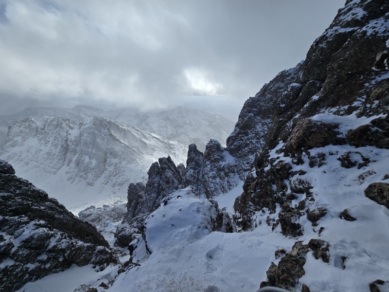
I looked around to study the area more completely to see if I had any options. On a rock next to me was someone's old belay gear left wrapped around a rock. In summertime I always find it kinda neat to solo up some fun route and climb past some old belay gear or webbing or whatever. But encountering that in winter when I'm alone and with no ropes was very disconcerting. 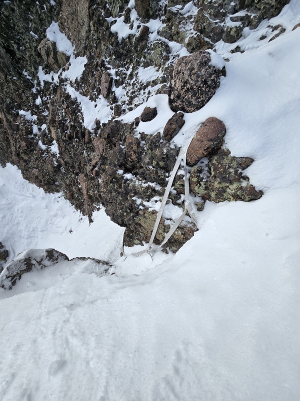
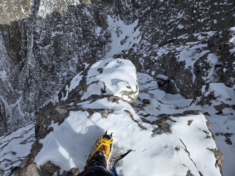
Now what do I do? How do I get out of here? Do I need to pull out my Garmin InReach and signal an SOS while I still can, before something goes even more wrong? This was the first time I've ever had serious thoughts about hitting the SOS button, but I knew it would, best case, take hours and hours for anyone to reach me and it was way too stinking cold out to sit motionless for hours. Plus that would disrupt and potentially endanger lots of other people, etc etc. No, SOS is an absolute last resort, after all other safe options are fully exhausted. I decided I needed to check around some more before taking that drastic step. Downclimbing what I came up would be extremely risky and extremely slow going - to be avoided if at all possible. Going straight up was out of the question - it looked to me at the time like something I would be very, very reluctant to attempt even in summer. Under the current conditions it seemed like total suicide. But that left one more option - straight across towards the gully I was supposed to be in. There appeared to be a small ledge covered with very steep snow going over sideways to a rock wall with a notch in it. The notch appeared to go over into the East Gully, though I couldn't tell if it cliffed out at the side of the gully. But it was my best chance. [For story telling purposes, I wish I had taken some more photos to help show what this area was like, but I was in full life-or-death survival mode at this point and so didn't take any more photos for a good while, so I'll just have to try to be descriptive, although I can fill in with some topo map shots snapped from the warmth of my home: spoiler alert - I don't die!!] Over the years I've often heard the refrain on the dot com that "if you don't have the beta, be the beta!" It's directed at those always asking people for beta on current conditions with the idea being, why don't you go out and gather the beta to share with others like yourself? Well in this case, I came up with a new moto: "If you don't have the SAR, be the SAR." (I know, I know... all SAR members are groaning and saying, "dude, that's exactly how people get in trouble." You're not wrong, but in this case I felt like I had very limited options due to the extreme conditions and with it being late enough in the day that no one could be reasonably expected to reach me before sunset). Please understand this is not a moto I suggest anyone pass along or live by - I'm just relaying the mental strategy I used to help extricate myself - namely, to pretend that I'm a SAR member going on a mission to extract someone else. That way the focus is off of me and my predicament and instead zeroed in on safely getting to the "victim" on the other side of the notch. So, with that mindset, I set off slowly and carefully over a ledge covered in snow much too steep for comfort and not nearly wide enough to be fully at ease (scroll 2 pictures up for a slight sense of this as it's the area a little to the right of that photo). I kept my straight shaft ice axe in self belay position, thrusting down into the snow, making sure my crampons made full purchase before entrusting any weight to them. After a very long minute or two, I made it over to the notch. At first I couldn't even bring myself to look over the other side. If I was cliffed out in that direction, then my only remaining option would be to try to downclimb the snowy/icy class 5 I had come up - why, oh why did I ever push up through that, despite knowing there shouldn't have needed to be class 5 on this route??? I took a few deep breaths and then finally stood up to look through the notch. The breath I let out next was half sigh of relief, half whistle of amazement/fear. The good news was that there was snow connecting from my position to the location I needed to be in to get back into the gully proper. The bad news was it was steep. Really, really freaking steep!!! [You'll note that I've only uploaded GPX tracks for Crestone Peak - none for Crestone Needle, because I don't want anyone to accidentally follow my blunders. But I'm including some snapshots below which show my mistake compared to the proper route so anyone reading can be careful not to make the same foolish blunder I made here. If you stay alert and aren't fighting variable visibility, and don't keep pushing upwards if you hit class 5, then you'll likely be fine. But note in the snapshots below how I passed through some black shaded regions for a bit (60+ degrees) then through different shades of purple (46-59 degrees) before getting back to the proper location in the East Gully.] 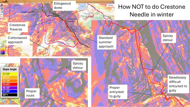
[It took a long time at home reviewing photos, gpx tracks, topo maps, etc to figure out exactly what went wrong but you'll note in the snapshots above that I failed to drop down far enough to hit the proper start of the gully, which put me on needlessly hard terrain from the get go, altered my angle of approach and generally threw off my orientation just enough to get me messed up - it was a perfect storm of conditions, assumptions and small mistakes that grew larger... but in the meantime, I'm still stuck above the gully - so back to the story...] I stood there for a moment looking at the steep snowfields. I knew that was the most reasonable way to get out of the mess I was in. I had on legit mountaineering boots (Nepal Cubes) with proper crampons and ice axe in hand. Boy, was I glad I didn't skimp on using proper gear!! I had been on very brief little spurts of slopes at a similar angle but this felt like a bigger, broader and taller stretch of crazy steep snow than I could remember being on. The first option was to head straight down to the bottom of the gully - abort this climb post haste! But as I looked down, it seemed the snow was even steeper that direction! Which led me to the idea that I needed to go straight across... and that's when it happened... No rational person would continue on at this point. The sun would be setting in less than 2 hours. I still had around 600ft of vertical elevation to get to the summit. But the best way out of my predicament was to cross over to where I would be exactly on course again - I couldn't turn back after all this effort and stress! But I quickly brushed aside all such thoughts: "Dude, you have to get yourself out of this mess first." I said to myself, "this snowfield is no joke - and if it's not stable you're screwed!" So I focused on the task at hand, being acutely aware of the position of every limb, the grip I had on my ice axe, the position I would need to be in to self-arrest as rapidly as possible if needed, etc. Everything I had slowly picked up over the years about snow climbing was about to be put to the test... With a couple more deep breathes I stepped out onto the snow. It was hard. Very hard. But I took that as a positive sign. That's what I need - snow that's been so blasted by the wind that it's not going to budge when I put my weight on it. That's what crampons and ice axes are for - giving you purchase on steep, firm snow. Step by step I moved out onto the snow. There was a sense of it being unreal. If only there was a freaking drone to fly by and get some sick video of this - this must surely look totally bad-ass from an aerial view! (says the dumb-ass who got himself stuck there in the first place). Little by little I worked across the snowfield and as the angle eased my hopes arose: "I can still do this!!!!" "Shut up and stay focused," I barked at myself. But slowly, ever so slowly, I finally got to reasonable terrain in the gully proper. Now the dilemma was real. I had already made a major screw-up. I had wasted a ton of time and energy. Sunset was fast approaching. Temps on the summit were sub-zero with wind chills as low as -20 to -30F forecasted. I had a very, very long return hike to do. But I was soooo freaking close. This was my 3rd attempt at Needle. I wasn't sure if I could bring myself back up here if I bailed. All of this was sounded a bit too much like the sloppy thinking that got me in the first mess. But I also realized that there was continuous snow all the way down the gully. I had revamped my glissading and self-arrest skills earlier on Crestone Peak and now felt confident I could make much better time on the way down by taking the snow. Plus I still had back-up layers I could add if needed to stay warm. And... I'm... so... freaking... close... Plus I'm feeling surprisingly good despite the long day... Hour 14 It's somewhere around 4pm. After cutting over from my spicy detour at 13,600ft I decided I was all in - I couldn't turn back. So I went up... and up... and up... 100ft of elevation; 200ft of elevation gain; 300ft of elevation gain - I was mentally estimating my progress. Dang, how much longer until the ridge?!?? I pull out the GPS - still not even at 13,700ft!!!! No, no, no, no, no, no, no, nooooooo!!!! This stupid thing has to be broken! That can't possibly be right!!! Oh good grief, no!!! I look around very carefully to make sure I've not gone off route again. I double check my GPS. Everything checks out except that it feels like I've been going up this stupid gully forever. I again consider turning back. Again no. Even harder no now. Not after all this! I'm getting this dang, stupid summit!!! Then I decide it's high time to call in the backup. TobyMac. The Elements. Wait, what the heck??? Where is it? I can't find the stinking song!!! Dang it - you've got to be kidding me! Well screw it, just hit the workout playlist - I could've sworn I added that song to it but I can't find it anywhere on my device now. Toby abandoned me in my hour of greatest need. That hurts man... Various tunes from the harder side of CCM start pumping through my earbuds. I push upwards with renewed passion. I concentrate on my form, focus on technique. Rest step, rest step. Legs, lungs, heart. Focus. Push. Keep going. Rest step, rest step. At looooonnnnnggg last, I reach the true ridge. Now just a true walk-up remains. My body is both weary and invigorated at the same time. I force myself up those last one or two hundred feet or so of gain and slowly see the familiar site of the "technical only" sign coming into view. It was like catching sight of an old friend you thought had died - I was almost in tears at the sight of that sign. 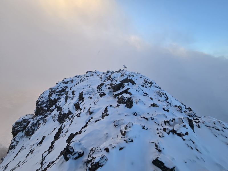
And as I walked up the last little bit I gaped in awe and wonder. I reached the summit at 4:54pm, just as the sun was going down behind the clouds that were partly covering nearby Crestone Peak. The photos unfortunately don't do justice to the vibrancy of the yellow and gold that filled the clouds. I felt almost like I was standing at the very gates of heaven. 
Hour 15 I had actually done it - I had made it to the summit of Crestone Needle in calendar winter! But now I had to get down safely and on my own two feet in order for it to count. The sun was literally setting below the horizon as I was standing on the summit. I knew I had to get moving fast. The further down the mountain I could get while there was still some lingering light, the better. I follow my tracks back to the top of the gully. I check visually. I check my GPS. I double check the landmarks and scan the route on the GPS. I can't screw this up. The descent is where countless people have messed up and gotten cliffed out. Everything checks out - I'm at the top of the correct gully. I have continuous snow now till the base. I double check my crampons - it's very dangerous to glissade with crampons if you get any speed up but I'm planning to keep my speed under control and want the crampons on in case I suddenly hit a really stiff patch of snow. Black Diamond ice axe is in hand in self-arrest position with a death grip on the shaft. The gully is pretty dang steep but I refreshed my arrest skills on Crestone Peak so I'm ready for it now. I had already plunged my hands into the snow too much on the way up - I knew I needed to minimize that on the way down, even with gloves on since it's so stinking cold. I sit down on my butt, heels of the crampons in the snow, ice axe gripped off to the side to slow progress and/or flip into full self-arrest if needed. It's now 5:20pm. Here goes nothing... I shoot off fast but I was ready for that and keep the speed in check with my axe. I'm churning up half inch chunks of wind slab plus the loose powder on top of the gully. It's starting to build into a moving pile so I bring myself to a full stop and watch the pile slid down 10 feet or so then stop. So I continue sliding down. This process of triggering mini-slides and stopping to make sure nothing picks up out of control continues for a few repetitions. Slide. Stop. Watch. Slide. Stop. Watch. Gradually the snow hardens and I'm not churning up much snow. I'm pushing the ice axe in harder now to keep my speed in check. Eventually I reach a section where I can tell it's about to get steeper and the snow is seeming pretty firm. Glissading feels too risky now. I get to my feet and spin to face down at the snow and commence a reverse front-pointing descent where my crampons are now controlling my descent and I'm holding the ice axe in dagger position to plunge into the snow for some extra security. But this arrangement has me pushing my right hand repeatedly into the snow and I know the cold and possibly some dampness is likely to eventually penetrate. I try to position myself to minimize the contact my gloved hand makes with the snow but I don't want to slow my descent and I know I have extra gloves packed specifically for the purpose of swapping out in the event of just such a scenario as this. Hour 16 6pm. I've finally reached the base of the gully. Thank goodness that went fast. Now I just need to cut over to where I can get back up on Broken Hand Pass. I move across some easy terrain then start dropping down a little scramble. This is getting kind of steep. Did I really start out on something this steep? I had my headlamp on reduced power with dispersed light to conserve batteries. Now I set it to full power with direct beam. Ah, there we go! There are my footprints in the snow at the base of the gully - almost there! Just need to climb down a bit more. I go down further, confident that I'm now almost finally done with this stinking gully. I get to within about 30ft above my tracks at the base of the gully. You've got to be kidding me... Oh crap, I think I just cliffed out. No, no, no, no, no, not again!!! Not this close! I'm so freaking close!!! I try slowly working down a little further where I see the angle isn't too bad, but as I get near the edge all I see is blackness - looks like it must be a sheer vertical drop for at least 15 feet or more. There's a less steep section between me and my tracks at the bottom of the gully but it looks 5th class and covered in snow with a little ice here and there. Briefly I start to entertain a really stupid idea: "How close to the bottom do I need to get before I can just fall the rest of the way and be ok?" No. Absolutely not. No. No No. Finally I tell myself the only thing to do is go back up to the correct point where I can regain my tracks and get out safely. I know there should be snow continuous all the way to the bottom, even though I had started out on some rocks because I hadn't wanted to drop all the way to the snow at the start of the climb. But after regaining 50ft or so and looking for a way to get back over to the snow, I'm unable to find a safe way to get over there. I'm no longer sure where exactly I came up - my tracks show I'm really, really close to where I came up but it sure feels much steeper than what I remember. Fatigue is starting to set in. I know I'm going to start getting cold if I spend too much time not moving. There is no question at all that I'm seeing my tracks from the way up in the snow below. I just have to figure out how to deal with that 30 feet of class 5. Well... same way as in the climbing gym, I suppose. Find a bomber hold. Maintain 3 points of contact. Search for that one extra hold to lower the left foot to. Ok, found one. Lower down to it. Now I need a hold for my right hand. I brush snow off of rocks looking for something solid. Found it! Ok, now right foot. I still have my ice axe strapped to my wrist - I extend it down to scrap away snow looking for the next foothold. Found one! Lower down to it. Now I need my hands free - I drop the axe and hear it clang against the rocks and then dangle by the strap. I use my left hand to brush away snow but I found a little ice underneath, so I pull the ice axe back up by the strap and chip away the ice. Now I have a hold for my left hand, so I drop the axe, letting it clang against the rocks and then dangle by the strap. Left hand now has a secure hold. Rinse repeat. Left foot. Right hand. Brush away snow. Right foot. Left hand. Pull the axe up - clear the route. Axe clangs on rock. Left foot. Brush snow. Right hand. At long last I realize I'm close enough to step down onto solid ground by my previous tracks. Hour 17 I take a long break at the what is the actual base of the gully. I realize that in the haste at the summit, I never took time for my special summit celebration - I had brought along a handful of Toffee Crunch Oreo's. They were intended to be my victory celebration - my Vict-Oreo's! I eagerly pull one out of the pack and bite down. Sigh. Apparently even Oreo cream freezes in sub-zero temperatures... I have to warm it in my mouth for a moment before biting it in half, then letting it sit in my mouth for a moment before being able to properly chew it. I leave the remaining Oreo's for later. It's now 7:27pm. I have one more sketchy climb up to do because I think I slightly missed the class 3 drop from higher up on BHP and came down something that felt harder than that. But compared the what I had just descended it now seemed easy. I'm not sure exactly what that descent was rated. Someone may go out to where the snapshot of my tracks runs and say it was only class 4. Or who knows, maybe they'll conclude it was mid 5th. I don't really know what to rank it. I only know that doing it as a downclimb, in the dark, covered in snow and ice, more than 16 hours into a day that started with only a couple hours of actual sleep, it sure felt like class 5 to me. Now I still had to navigate along or below all the gendarmes and such to get back over to Broken Hand Pass. Thankfully I had tracks in the snow to follow. Until I didn't. Damn wind. Ah, there are tracks again! Dang lost them again. Check the GPS. Ugghhh, why did I leave every GPS track ever visible on the map? Which one am I supposed to follow? I don't feel like messing with this - there was some track here at some point - just keep moving. Found footprints again. Lost them. I see some more over there... Hour 18 It's 8:48pm. It felt like it took forever, but I'm finally dropping down Broken Hand Pass. I'm having trouble spotting my snowshoes. That's when I realize that I had bumped my headlamp up to full intensity near the bottom of the gully and had never lowered it back down. Now the light is fading fast. I push ahead to anywhere where I can see a hint of darkening in the snow, checking any exposed rock for my snowshoes, but I can't find them. Dang, I knew I should have dropped a waypoint... I stop at a random rock so I can put in fresh batteries for my headlamp - my entire backpack and all my gear is coated in a layer of frost. I brush things off as best as I can and swap out the batteries. Now, with strong light again, I look and easily spot my snowshoes propped up against a rock a short distance away. I lug everything over there and switch from crampons to snowshoes and trade ice axe for trekking poles. A full moon has now risen over BHP and is shining on Cottonwood Lake, Crestolita and the Crestones. There is a mesmerizing beauty and serene peacefulness to the scene around me. Part of me wants to stay there and soak it in longer. Part of me wants to just go to sleep. But my survival instincts tell me I need to get moving. Hour 19? 20? Time plods on and so do I. I stopped taking notes on my phone after reaching the base of BHP. I just want to get this hike done. I make it to the top of the chimney by the falls. Briefly consider trying to downclimb in snowshoes but figure that would be much more difficult than the climb up was so I swap out for microspikes which I keep on for the rest of the hike, despite some post-holing here and there. Hour 21? 22? 23? What time is it? What day is it? Seriously, is it still Tuesday, or is it Wednesday already? I don't care enough to pull out my phone. I don't want to break the seal of my sleeves pulled up over my gloves that keep the frigid air out in order to check my watch. Is it above zero down here? I don't know. I don't care. My layering system is working. My body temperature is stable. Hands are still a little cold. I stick my right hand under my armpit for a bit since it was punched into the snow the most frequently and still not as warm as I'd like. I had swapped out gloves at the bottom of the gully - or was that the bottom of BHP? I don't remember. I don't care. Just keep moving. It's a huge plus that I'm walking this route for the 4th time in less than a month. I can walk it in my sleep now. I am walking it in my sleep now. No, I'm still awake. I think I am. I'm not sure. I don't really care. Just keep walking. It's 11pm now. Or maybe it's midnight. Might still be 9:30pm. Could be 1am. Who knows. Who cares. Here's that one turn I almost missed on the way up. Got it - real trail is that way. There's one of the head banger trees leaning over the trail that I cracked my head on during the first return trip. Lean underneath without problem. Step over a fallen tree. Another one. Duck under the next head banger. Finally at the slabs. Watch the footing. Careful. Careful. Past the ice sheets now. Past a small stream crossing. Another one. Getting closer. Every exhale is creating a large cloud in front of my face. I'm breathing heavy enough that the cloud seems to never dissipate. Which is fine because it gives me something to distract my attention with. I... am... so... tired... I brush off a log and sit down for a brief moment. I can't go on. But I have to. I'm warm enough now but I won't stay that way if I stop for too long. I get up and plod along some more. I...... am...... so...... tired...... I pause and lean my head against a large tree and close my eyes for just a brief moment. I can't keep going. But I must. I keep pushing on. I............ am............ so............ tired............ At some point I realize that I don't have any music playing. Somewhere along the line I had unplugged the earbuds in order to plug in the battery pack so my phone wouldn't die. The charger was working pitifully slow because of the extreme cold, even with it kept in a pocket next to my chest in the layer underneath my puffy. But it had enough charge now that I should be able to get back to the trailhead. I pause to unplug the battery pack and plug the earbuds back in - I think I had left the earbuds in and had just unplugged the USB-C cord. Now I've got music pumping once again. Hour 24 I had noticed when getting the music turned on that it was indeed Wednesday already, though I didn't really pay attention to the specific hour. The music was a lifeline - the motivation my wearied body needed to keep plodding along; a distraction from the agony of this victory I was in the process of winning. The last mile of any trail is always the longest. It equates to 3 or 4 or 5 normal miles. Science have proven that space/time distortions actually lengthen the distance on the return journey. This is a proven fact - you can trust me on this; I've been hiking for 24 hours straight and so my logic is impeccable... I don't remember exactly what songs were playing as I strode those last bits of distance - a little Matt Maher, some Danny Gokey, maybe NeedToBreathe... but the music fueled me to the finish. Finally, all of a sudden, my 4Runner pops into view. Wednesday 2:28am. I hug my 4Runner. It had been 24 hours and 20 minutes since I had seen it last. I quickly de-gear, load into the 4Runner and take the 18 minute drive to Bliss Inn where I quickly proceed to find my bliss... Conclusions All in all, this was one heck of a journey. I pushed myself harder than I've pushed before. I succeeded in getting the summit of both of these peaks and I also succeeded in having the right gear to allow me to stay safe and warm despite intensely cold temperatures. I did make some initially small mistakes that compounded very quickly into what could have become life-threatening danger. But, with some effort, I kept my cool and used the skills I've developed over the years to safely extract myself from danger. Having not died, I'm now a little wiser and will know to watch out for those nasty little assumptions (oh, the ridge is just right up there...). I know now the importance of not assuming that I'm familiar enough with the route that I don't need to stop and double check my position. I realize now that even for familiar sections where navigation is expected to be easy, all it takes is a little bit of fog, a little bit of snow, a touch of impatience and suddenly things can go really, really wrong. I'm extremely glad I did these peaks before attempting Capitol in winter - and, yes, that is still on my radar. But you can be sure that I will be taking route-finding very, very seriously on that one. I won't likely be doing it any time soon given the nasty avalanche conditions that part of the state has had most of the winter but perhaps come the end of winter... At least one other thing I learned - despite trying to keep my hands out of the snow while going up and down the gullies, and despite bringing extra gloves to swap out, I did end up with some degree of frostbite on the tip of the middle finger of my right hand - there's a slight bit of numbness remaining as I type this, but thankfully no blisters or discoloration (I did do a quick connect with my doctor to check it out). The #1 goal I had listed in the 2025 Goals thread on the forum was:
I think I can already mark that one a success now, though I look forward to adding some more in the months ahead! Final note to my homeboy TobyMac: man you let me down!! You left me hanging on the way up Crestone Needle! But hey, we'll call it all good if you give me free tickets to your next show! ;-) GPX NOTE: Just to reiterate down where it will show up near the map, I'm only loading the GPX tracks for Crestone Peak. Crestone Needle uses the identical approach and then you take the Crestone Peak trail back to BHP before joining the standard route for Crestone Needle. Those files can be found on the peaks pages. I did include snapshots of my Needle route (4th from last photo above) but won't be posting the GPX so that no one accidentally thinks it's the proper route to take. Thumbnails for uploaded photos (click to open slideshow): ")
")
")
")
")
")
")
")
")
")
")
")
")
")
")
")
")
")
")
")
")
")
")
")
")
")
")
")
")
")
")
")
")
")
")
")
")
")
")
")
")
")
")
")
")
")
")
")
")
")
|
| Comments or Questions | ||||||||||||||||||||||||||||||
|---|---|---|---|---|---|---|---|---|---|---|---|---|---|---|---|---|---|---|---|---|---|---|---|---|---|---|---|---|---|---|
|
Caution: The information contained in this report may not be accurate and should not be the only resource used in preparation for your climb. Failure to have the necessary experience, physical conditioning, supplies or equipment can result in injury or death. 14ers.com and the author(s) of this report provide no warranties, either express or implied, that the information provided is accurate or reliable. By using the information provided, you agree to indemnify and hold harmless 14ers.com and the report author(s) with respect to any claims and demands against them, including any attorney fees and expenses. Please read the 14ers.com Safety and Disclaimer pages for more information.
Please respect private property: 14ers.com supports the rights of private landowners to determine how and by whom their land will be used. In Colorado, it is your responsibility to determine if land is private and to obtain the appropriate permission before entering the property.