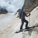
Started from Zapata Falls Trailhead and headed up the trail to Zapata Lake, I won't add too many details since Ben (Supranihilest) has a good report for Twin Peaks. I tagged Twin Peaks A North then headed over to South which is a 5 minute walk. The view up here of the Blanca Massif is quite lovely, and you can see the Sand Dunes and Crestone area which is quite nice as well.
From the summit of Twin Pk South I dropped down the east ridge heading towards recently added unranked 'Crossfire Ridge'. The ridge starts off easy enough with some class 2 talus before becoming a neat broken knife edge ridge for a good distance which was fun to scramble along, there was some loose rocks to watch out for since this ridge is probably relatively untraveled. While still descending the ridge starts to have some small notches which have some scrambling going up and down each side, it was mostly class 3 except the downclimb on maybe the 3rd and 4th notches which were both class 4 and maybe 10 and 25 feet respectively while trying to stay as close to the ridge crest as possible (I am sure there are work arounds but I did not look for them). Once you get to the low point of the west ridge the route goes back to tippy talus as you head up the broad subsummit to the west of Crossfire, this subsummit looks higher from just about everywhere, but I had added the GPS coordinates from LOJ on my CalTopo and knew it wasn't the correct summit in spite of the small cairn constructed at the top, so I continued over to the true summit which had a small amount of class 3 but was mostly 2+ as well.
Leaving the summit of Crossfire and heading east, the route joins up with the Ellingwood Ridge north ridge route from Zapata Lakes briefly in a loose talus field, so following the beaten in path was kind of nice in this area. Once at ~13600 ft at the top of the east to west ridge I headed down a north east facing class 3/4 chimney, then followed the ridge crest north down some class 3/4 slabs. This area was some of the more difficult and most exposed climbing of the day, but it was still pretty fun and easy enough climbing in my opinion. I skipped some of the scrambling along the ridge at this point and followed a grassy slope on the west side of the ridge about 100-150 ft from the ridge crest to expedite my travel, but headed up and over the south sub-summit of 13656 and a long the ridge crest to the true LiDAR summit of 13656 which I failed to tag a few years ago while doing California-13660 (prelidar). I love the view to the south from this peak and I was happy to be back here and on the true summit this time. I didn't stay for to long as I wanted to get down and back on the road before dark and still had a ways to go.
There is a little more scrambling mostly class 3 to the old summit now called UN 13654, which I briefly walked over but did not stop before heading east down this ridge towards the saddle with UN 13577. Once at the saddle I descended north into the North Fork South Zapata Creek basin towards the trail which is lovely grassy tundra up high in the basin before turning into talus trail and finally entering the forest. There is a really neat to see, airplane crash in this basin with parts of the fuselage scattered for probably half a mile, last time I was in the area I stumbled across some of the landing gear and cylinders from the motor, but I think I went slightly further east this time and missed them.
Overall my GPS said 14 miles (maybe a slight underestimate) and 10:15 round trip, including 1 hour spent on Teams trying to do work on a Friday. I think this route was a fun way to link together the newly added Crossfire Ridge and the new UN 13656 I missed as well as the Twin Peaks A group. There was a decent amount of scrambling involved and a lot of tedious talus slogging so moving was slow at parts. If you aren't comfortable with down climbing class 4 I would recommend reversing the direction since all of the class 4 was downclimbing starting with Twin Peaks A.
https://asn.flightsafety.org/asndb/332484 link to crash info and report.
")
")
")
")
")
")
")
")
")
")
")
")
")
")
")