Download Agreement, Release, and Acknowledgement of Risk:
You (the person requesting this file download) fully understand mountain climbing ("Activity") involves risks and dangers of serious bodily injury, including permanent disability, paralysis, and death ("Risks") and you fully accept and assume all such risks and all responsibility for losses, costs, and damages you incur as a result of your participation in this Activity.
You acknowledge that information in the file you have chosen to download may not be accurate and may contain errors. You agree to assume all risks when using this information and agree to release and discharge 14ers.com, 14ers Inc. and the author(s) of such information (collectively, the "Released Parties").
You hereby discharge the Released Parties from all damages, actions, claims and liabilities of any nature, specifically including, but not limited to, damages, actions, claims and liabilities arising from or related to the negligence of the Released Parties. You further agree to indemnify, hold harmless and defend 14ers.com, 14ers Inc. and each of the other Released Parties from and against any loss, damage, liability and expense, including costs and attorney fees, incurred by 14ers.com, 14ers Inc. or any of the other Released Parties as a result of you using information provided on the 14ers.com or 14ers Inc. websites.
You have read this agreement, fully understand its terms and intend it to be a complete and unconditional release of all liability to the greatest extent allowed by law and agree that if any portion of this agreement is held to be invalid the balance, notwithstanding, shall continue in full force and effect.
By clicking "OK" you agree to these terms. If you DO NOT agree, click "Cancel"...
I've been a little too connected as of late, and I needed to fix that. There's no place better than the South San Juans for disconnecting and feeling like the world is delightfully large. There's no month like September to go hiking in CO.
There's not much about my trip that contains beta that would improve your life. It's mainly a photo dump. But honestly, if you need my advice or input, you're probably fucked. This is not limited to the mountains.
Bennett Peak
Not a whole lot to say about this one. It was a fine hike, and I saw zero people, but trails popular with dirt bikes just aren't amazing hiking trails.
Highlights:
Clear skies eventually (though I was very sad "eventually" meant 4 AM).
Testing out my ~30ish year old 50mm 1.4 lens for astrophotography. Turns out that the materials science has improved significantly over the course of the intervening decades. I'm convinced it has the biggest disparity between attention and impact of all the past technological changes in the past 50 years.
Seeing some very large hawks (I'm guessing) take off.
Having a hawk discover that I'm having a beer at my campsite as it flew 20 yards over me, and screeching to let me know it had spotted me.
Platoro
I wasn't entirely sure I should've driven on the bridge over the Alamosa river near Stunner campground, given that it's partially under replacement and definitely looks sketchy. I didn't think about it too much and also didn't die. Also I learned that it's still functional as the new bridge will be built in parallel to the old one. Civil engineering: it's fine!
Highlights:
Rockfall that woke me up at 3 AM.
Seeing the mist on the reservoir with my headlamp at 4 AM.
Stupid condensation ruining a perfectly good night-to-day timelapse. The downside of the aforementioned mist.
Second rockfall at 6:30, when I realized what it was (and not actually some yahoos shooting guns at 3 in the morning, like I first thought). This video does not have the rockfall. Sorry.
So many birds. I took the wrong lens on the hike that day. Otherwise, just a very pretty valley.
Winston, who used me as a salt lick at the Gold Pan Cafe, then cleansed his palate by licking the table. They didn't have bread pudding at the moment, but I learned that the trick is "stale buns, Betty Crocker recipe, double the whiskey in the whiskey sauce".
Conejos
Man, I don't like that road. Easy 4WD but I'm just not great at exposure in a car. I did do way better at taking the easier but exposed line on the way down.
Trump Derangement Syndrome.
I'm sad that we've functionally ceded the San Juans to Texans. But I'll take the money they pay for the hunting tags.
Many, many Texans I've met along the way tell me how superior the state is. They always tell me this when they are visiting or living in a place that is not Texas.
Now I want to put a "Bernie Edition" badge on the Forester. I've never even voted for the guy, but if one wanted to lean into all things Vermont and we already have the Subaru...
(One of my friends is from Vermont and was actually staff for Bernie. She has a cheese drawer in her fridge with a selection of a half-dozen cheeses at any time. She's living life right.)
As I was walking up the road in the morning, I caught a glimpse of a bright light below the horizon. I did a double-take, and definitely saw eyes looking at me from ~30 yards away. I kept moving - I'm not good at species identification in the pitch black (or, in the daytime), and I'm especially not motivated when said identification could possibly include "mountain lion".
There's less "trail" on the stretch between Conejos and and Hansen Creek than one might expect. I'm used to trail-less hiking, but it was surprising to do at a place where the map indicated that there was trail.
Also, there is a game/social trail on the approach down to Saddle Creek that is definitely not on the map. If you're on autopilot at 4:30 AM and expecting it to be zero-choice hiking, and start to descend in the opposite direction from your objective...you're right that you're wrong.
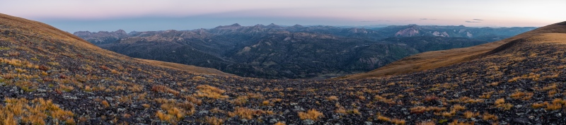
The expanse of it all. Being able to see the Sangres silhouette across the valley in the sunrise was pretty magical.
No, really. I maybe took a 250 megapixel pano at the saddle above Tobacco Lake, and that only scratched the surface of what it's like being back there. This is clearly not full scale. Come on now.
Caution: The information contained in this report may not be accurate and should not be the only resource used in preparation for your climb. Failure to have the necessary experience, physical conditioning, supplies or equipment can result in injury or death. 14ers.com and the author(s) of this report provide no warranties, either express or implied, that the information provided is accurate or reliable. By using the information provided, you agree to indemnify and hold harmless 14ers.com and the report author(s) with respect to any claims and demands against them, including any attorney fees and expenses. Please read the 14ers.com Safety and Disclaimer pages for more information.
Please respect private property: 14ers.com supports the rights of private landowners to determine how and by whom their land will be used. In Colorado, it is your responsibility to determine if land is private and to obtain the appropriate permission before entering the property.
")
")
")
")
")
")
")
")
")
")
")
")
")
")
")
")
")
")
")
")
")
")
")
")
")
")
")
")
")
")
")
")
")
")
")