Download Agreement, Release, and Acknowledgement of Risk:
You (the person requesting this file download) fully understand mountain climbing ("Activity") involves risks and dangers of serious bodily injury, including permanent disability, paralysis, and death ("Risks") and you fully accept and assume all such risks and all responsibility for losses, costs, and damages you incur as a result of your participation in this Activity.
You acknowledge that information in the file you have chosen to download may not be accurate and may contain errors. You agree to assume all risks when using this information and agree to release and discharge 14ers.com, 14ers Inc. and the author(s) of such information (collectively, the "Released Parties").
You hereby discharge the Released Parties from all damages, actions, claims and liabilities of any nature, specifically including, but not limited to, damages, actions, claims and liabilities arising from or related to the negligence of the Released Parties. You further agree to indemnify, hold harmless and defend 14ers.com, 14ers Inc. and each of the other Released Parties from and against any loss, damage, liability and expense, including costs and attorney fees, incurred by 14ers.com, 14ers Inc. or any of the other Released Parties as a result of you using information provided on the 14ers.com or 14ers Inc. websites.
You have read this agreement, fully understand its terms and intend it to be a complete and unconditional release of all liability to the greatest extent allowed by law and agree that if any portion of this agreement is held to be invalid the balance, notwithstanding, shall continue in full force and effect.
By clicking "OK" you agree to these terms. If you DO NOT agree, click "Cancel"...
My thanks to Amy (Blazintoes) for some beta on her trek up North Pole Basin, and the observation that a shuttle would make for a fun outing to ascend North Pole Basin and descend to Paradise Basin. Also, prior reports on the Treasure and Treasury peaks were helpful.
July 4 was a Thursday this year, and I drove to Crested Butte with my friend John that day for some hiking in that lush mountain paradise for the holiday weekend. In advance of Friday's point to point "Treasury Twosome Traverse," we parked my car at Paradise Divide, riding mountain bikes back down to our camp by the creek in Schofield Park. (This area was west of the creek in the area of the USGS topo between the creek and 10,400 on the topo line). This served as a decent camping spot for two nights, but the mountainside to our west cast us in deep shade by 6:30 each night, and the creek lowered the temperature significantly, creating frost on the grass and our tents, when areas much higher in elevation stayed dry.
In the morning, we headed up the old road that leads to North Pole Basin. This used to be private property (until 2016 I think) and has since become federal land for conservation and scientific research.
Heading up an old road, we didn't expect any navigational challenges, but we encountered a couple ponds, and the road disappeared. We somehow found ourselves in the densest stand of young fir trees I have ever encountered, on some steepening slopes, and I espied the road to our left. We extricated ourselves from the unplanned bushwhack and regained the road. To avoid this mishap, don't look for a way to cross the first pond - spend more time than we did looking around to find where the road might lead through this section.
The old road made for efficient progress up the basin. It was a clear, beautiful morning, and the hills indeed felt alive, if not with the sound of music.
As we continued up North Pole Basin, a prominent couloir on the east face of Treasury Mountain caught my eye. I'm sure many a local backcountry skier has done this one.
Our route for the day was not to go to Treasury Mountain from here, but to drop into Bear Basin and hit Treasure Mountain before Treasury. The flat ridge separating the two basins revealed itself to be a scenic spot. Below is the view north across lower Bear Basin and unranked Bear Mountain.
We turned our eyes south, to the first peak of the day: the twelver, Crystal Peak, sharing the same name as the river running by our camp.
Starting as a mere grassy walk, the terrain on Crystal became a bit more exciting as we advanced. We found some fun, sporty but easy class three sections before gaining the summit.
After spending a few minutes on the summit to get a snack and take in the views, we reversed our way. From the base of Crystal's west ridge, our way ahead was laid before us: down to find a way through the short cliffs into south Bear Basin, around Treasury's NE bulwark and through upper Bear Basin to gain Treasure's south ridge. Out of sight was our way up Treasury, since its connecting ridge with Treasure doesn't go. In the picture below, the camera cannot see what our eyes could see far, far to the right - the top of Treasure Mountain, our next summit.
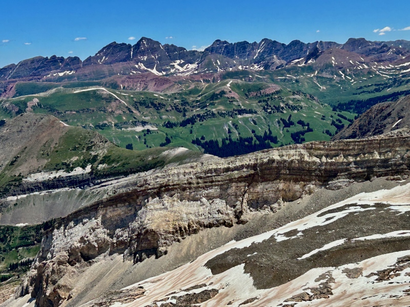
But before we started that next part of the journey, I glanced back toward Crystal. The sun had climbed a bit higher in the sky, affording better views of the fourteeners to the east of us, and I took a minute to enjoy the view of the Capitol-Snowmass-Hagerman massif.
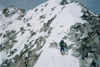
As we walked the flat ridge dividing the North Pole and Bear basins, I looked ahead for where I would find a good place to drop into the latter basin. I imagine there are many opportune areas, as John opted to drop sooner than I and that worked too, but just for an idea, below is what my view west looked like at the spot where I navigated a brief class 3 down climb through the cliffband into Bear Basin.
Here is a view back up of the descent through the cliffband:
This year was an average winter (for what passes now vs 20 years ago) followed by a solid spring snow season, so we had a mix of snow and rock as we traversed the basin. As we made our way northeasterly out of this eastern pocket of Bear Basin, I enjoyed a short section of grass and exposed slabs, which made me think of place like Garfield/Graystone basin in the Weminuche. Also, an aesthetic fin to the south captured my attention. @monster5, go climb it!
The way forward, to gain the western side of Bear Basin.The talus was pretty well set, so that it was not too slow to navigate, while the snow was firm and provided quick egress.
Once we got into the west side of Bear Basin, near that spur of ridge that juts north from Treasury to divide the two halves of the Bear, we found a long, moderate snowfield ahead of us. We donned our microspikes and broke out the axes for this section; it was low-angled and made for a pretty quick ascent. John was carrying too much gear for this day, so I outpaced him on this slope. Below is a view back to him and across to some splendor of the Elk range.
In order to continue on snow all the way to the saddle, we would have to deviate south (hugging the shadows of Treasury). We just kept a pretty much straight line, and so had a few talus spots. When completely dry, I think this basin is mostly talus and large slabs, and might afford more class 3 scrambling on said slabs. Bear Basin becomes slabbier and more alpine in nature the closer one gets to the east ridge of Treasure Mountain that confines the basin to the north. We were nowhere close to that part, but traversed the section of the basin right where the "12,000" appears below "Bear" on the USGS.
Upon gaining the Treasury-Treasure saddle (which I now dub the Treasure Chest), I scrutinized the ramparts of Treasury's north ridge. I guessed the troublesome notch that rendered this ridge a "no-go" must lie just out of sight behind the pointy section lower down in the sunlight, between it and the small dark shadow just above.
From the Treasure Chest, the route to Treasure mountain looked like this. The summit is at far right.
We made our way without incident up the ridge and to the summit of Treasure Mountain. Riches dazzled our eyes: views to the east of gorgeous (if treacherous) Elk ridges and famed/notorious fourteener summits.
Capitol and Snowmass, Hagerman (again - I know, how boring):
Sleeping Sexton, Maroon Bells, Pyramid and the Pyramidal traverse.
We indulged a little more time atop this summit, as no clouds threatened on the horizon. Once we decided it was time to move again, we descended swiftly down the easy ridge. Then we dropped into the wide Yule Basin to the south.
A look back up to the Treasure Chest from our descent into eastern Yule Basin.
From prior reports, we knew to look for the old mining cables, and they were easily located. We first found a grassy slope as the logical way to start contouring back up to Treasury Mountain, and stumbled across the cable.
The initial grassy part became rockier, and, characteristically of the Elks, many of these rocks were not attached to the mountain, so some care was needed.
The way ahead opened up, expanding dramatically, and it seemed that the summit was near. It wasn't, and this section proved much slower and tedious than expected. It took us another hour to the top.
As I moved upward (towards the snowfield in the preceding photo), I experienced a moment that happened so quickly that I was only terrified afterward. Looking ahead, I saw a black object hurtling toward me. It whizzed by my head, within two feet of my right ear, moving so quickly that I couldn't distinguish it. I estimated it was a cantaloupe sized rock and scanned the heights to see what had caused the rock to come careening so near to ending me. My heart was pumping and I forced my breathing to slow. At this point, John was some distance behind and far right of the course of this projectile. Upon reflection later, I concluded it was not a rock but a dive-bombing bird - raven or crow - because I never heard any crash of a rock falling behind me, and also because the slope didn't seem steep enough to launch the rock on that trajectory.
Following the cables en route to the summit (after the experience of the kamikaze crow) I came to the old mine. Below is the view south from the mine.
Some of the rocks around the mine featured small turquoise deposits.
Atop Treasury Mountain, we reveled once more in the spectacular views of the Maroon Bells wilderness to the east. Here's one more slice of heaven:
After soaking up the sun and serenity on Treasury, we headed down the much more benign south ridge. Quickly we came to the top of the colouir; I think this is the same that I saw on our walk up North Pole Basin.
Then the ridge presented a fun blocky constriction - nothing one can call scrambling, but interesting.
After that, we enjoyed the long easy stroll down to Paradise Divide.
As we made our way down, I took in yet another amazing view of Capitol, Snowmass, and Hagerman. Unlike the preceding photos of this group, this shot captures Crystal, our first peak of the day, the foreground.
We reached the car 10 hours and 56 minutes after we began. (Summit breaks summed to about an hour.) During that time, we had only seen one other person, a hiker heading up to the Treasure Chest from Treasury before we gained the cables. The sudden clusters of cars and groups of people felt like a crowd after such a day of solitude.
My GPS Tracks on Google Maps (made from a .GPX file upload):
Just an FYI, the couloirs are locally known as the "wine bottle couloirs" (there are actually 2 of them). You likely would have seen tracks in them on July 5th, as it's a very popular 4th of July ski and I know several people skied it this year. That's a nice tour you had!
I didn't see any tracks but we were too far away on the approach and then I didn't peer too closely at the top. I figured we had to be crossing terrain well-known by locals. Such a great place to spend a day.
Finished the Gores a couple weeks ago and the Front Range last night. Itll be a while until I finish the Elks because they arent fun scrambles like Gores or FRange.
Seeing White Mtn from Triangle last week had me thinking, yuck. Have you done the that one yet?
Loops are more enjoyable. Glad it worked out for you two.
This looks like a great approach. Not sure why we trespasswhacked up/down Bear Basin (in 2018) except for weak planning.
Caution: The information contained in this report may not be accurate and should not be the only resource used in preparation for your climb. Failure to have the necessary experience, physical conditioning, supplies or equipment can result in injury or death. 14ers.com and the author(s) of this report provide no warranties, either express or implied, that the information provided is accurate or reliable. By using the information provided, you agree to indemnify and hold harmless 14ers.com and the report author(s) with respect to any claims and demands against them, including any attorney fees and expenses. Please read the 14ers.com Safety and Disclaimer pages for more information.
Please respect private property: 14ers.com supports the rights of private landowners to determine how and by whom their land will be used. In Colorado, it is your responsibility to determine if land is private and to obtain the appropriate permission before entering the property.


")
")
")
")
")
")
")
")
")
")
")
")
")
")
")
")
")
")
")
")
")
")
")
")
")
")
")
")
")