Download Agreement, Release, and Acknowledgement of Risk:
You (the person requesting this file download) fully understand mountain climbing ("Activity") involves risks and dangers of serious bodily injury, including permanent disability, paralysis, and death ("Risks") and you fully accept and assume all such risks and all responsibility for losses, costs, and damages you incur as a result of your participation in this Activity.
You acknowledge that information in the file you have chosen to download may not be accurate and may contain errors. You agree to assume all risks when using this information and agree to release and discharge 14ers.com, 14ers Inc. and the author(s) of such information (collectively, the "Released Parties").
You hereby discharge the Released Parties from all damages, actions, claims and liabilities of any nature, specifically including, but not limited to, damages, actions, claims and liabilities arising from or related to the negligence of the Released Parties. You further agree to indemnify, hold harmless and defend 14ers.com, 14ers Inc. and each of the other Released Parties from and against any loss, damage, liability and expense, including costs and attorney fees, incurred by 14ers.com, 14ers Inc. or any of the other Released Parties as a result of you using information provided on the 14ers.com or 14ers Inc. websites.
You have read this agreement, fully understand its terms and intend it to be a complete and unconditional release of all liability to the greatest extent allowed by law and agree that if any portion of this agreement is held to be invalid the balance, notwithstanding, shall continue in full force and effect.
By clicking "OK" you agree to these terms. If you DO NOT agree, click "Cancel"...
I set out at 4:45AM from Durango and pulled into the Kendall mountain rec area parking lot around 5:45AM. Loitering in my car for about 15 minutes, I ate a hard boiled egg and a donut while lacing my shoes. It was just before 6 when I started hiking.
I knew from other trip reports that combining all of these peaks would be possible, but it is most often done with a 4x4 vehicle. I am no stranger to road miles but I wanted to avoid walking the Kendall gulch road twice. So to this end I mapped out a loop utilizing the Swansea gulch “trail” for my ascent and the Deer park/Kendall gulch roads for my descent. Most of the route is gentle save for a stretch between Kendall Mountain and Kendall Peak.
Back to hiking, I set off on the hardrock 100 trail by headlamp. My time on the hardrock trail was brief, as I soon intercepted CR20, which initially switchbacks up and then away from Swansea gulch. I left the road at a switchback by a nice, newer cabin. Investigating the cabin area I quickly drew the conclusion that it was definitely the lair of the infamous Silverton sourdough cult. They vehemently believe that bread is superior to the tortilla. Moving on, following the Swansea gulch “trail” is a fools errand. The semblances of trail leaving the cabin area are both mismarked and quickly swallowed by growth - likely seeded years ago by the bread cult in an effort to thwart my progress. No matter, the bushwhack wasn’t too bad. Soon after breaking treeline I did rediscover the trail but it again disappeared into the talus. Travel upwards was steep at times but easy.
Ice Lake peaks
After reaching the upper basin I turned right to head up a broad, grassy gully. There is a long abandoned road grade here that switchbacks partway up the gully, ultimately connecting to the saddle between Kendall BM and Kendall Mountain. I ignored this road as it was just as grassy as the slopes. There were some cool sealed mine adits a third of the way up the gully which I stopped to admire. I summited Kendall BM just after 8:30. I enjoyed a snack break and then continued along the ridge to Kendall Mountain, which I reached at 9:30.
Mining history is so interesting.
All of the beta I had read indicated that staying on the ridge between Kendall Mountain/Peak would be challenging if possible. Being stubborn, and not wanting to drop the elevation into Kendall gulch, I elected to investigate. The ridge here was gentle initially, innocently luring me towards its ugly surprise.
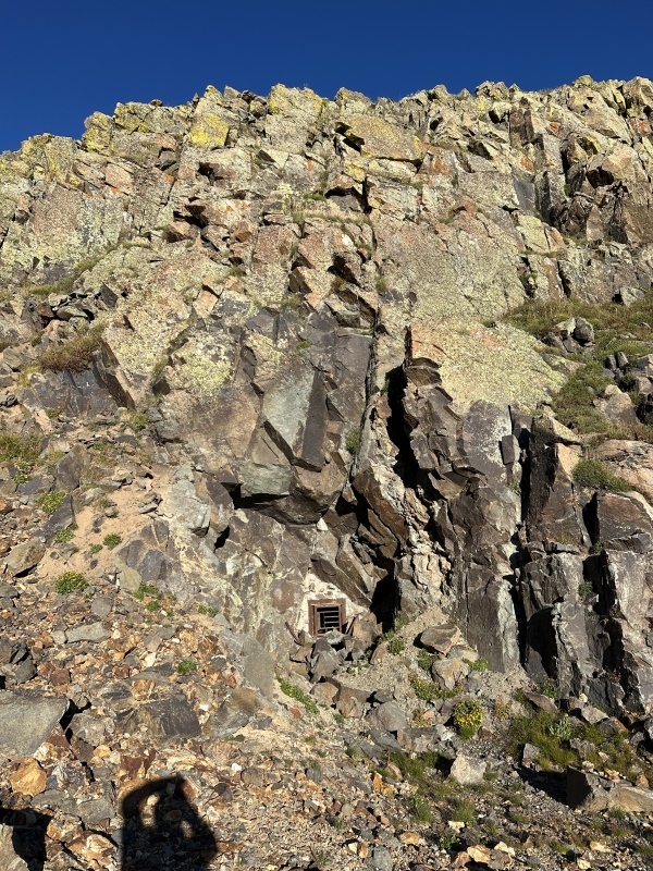
After passing a neat high point the ridge changes nature very quickly and dramatically. I spent a good 10 minutes here, eyeing the decomposing rocks before me. The eastern, opposing side looked more solid, albeit steeper. There was a headwall guarding the upper ridge, bisected by what appeared to be a steep, blocky gully. The gully angled into the headwall, hiding behind a corner, so I couldn’t see the top of it from my perch. Beneath me was a terrifyingly magnificent system of decomposing cliffs. The rock was rotten. Straight dinner plates, with the occasional bowl thrown in for structural inconsistency. Perhaps I am too gentle with that description, for these plates had been shattered, glued back together and re-stacked. In the middle were two adjacent towers, both composed of the same heinous rock. Between the two towers I spied a gap, teasing me with the idea of viable passage.
My initial vantage of the obstaclesA closer look at both the ramp system and the gap between the towers.
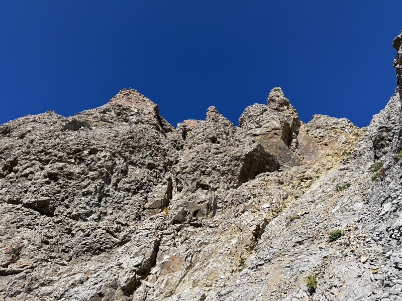
The gap was a magnet and I was lured down a sinuous, mostly class 2 ramp system towards the tower. The terrain here is complicated and hard to describe, but I snaked down the ramp system before entering a tiny, dirty North facing gully. I descended 5ish feet in this and then regained the ramp system. This brief detour from the ramp was to avoid a mini, exposed, decomposing rock formation blocking easy passage. Back on the ramp, I scurried down more broken rock into another short gully which yielded to scree. Time to check out the gap.
Below the ramp system, looking back at the rotten cliffs it avoided. Don't look too long or they will fall apart.
After entering the gap I was ecstatic to find a narrow slot which permitted access to the eastern headwall. It was a cool squeeze, I had to turn sideways to get through. One class 3 move deposited me down onto more loose rock beneath the headwall. Moment of truth. Finally gaining line of sight around the corner, I was stoked to see a blocky, solid-ish, ~20 foot class 4 line which would deposit me onto the talus above the headwall. The scrambling here was fun and the rock much better, albeit some blocks still being loose. I romped up the large, stable talus towards Kendall Peak’s summit; taking care initially as I was traveling above cliffs. I topped out just before 10:30. The rest of the hike reverted to the mellow nature of the day's beginning.
After squeezing through the slot you are greeted by the headwall.Looking up, I climbed just right of center.Looking down.
I enjoyed Kendall Peak for a while, feeling smug that I had managed to stay on the ridge. Ironically I did leave the ridge soon after, using the tail end of the Buckeye trail to cut around the north side of “Spencer peak.” The trail here is good for San Juan standards and it was nice to not sidehill talus. I left the trail as it fizzled out, turning south and heading across beautiful fall tundra. The tundra here was occasionally interrupted by strips of scree and talus. Travel was easy and enjoyable. Eventually I regained the ridge and followed it up “Mountaineer Peak.” Eyeing Rhoda, I didn’t stay long.
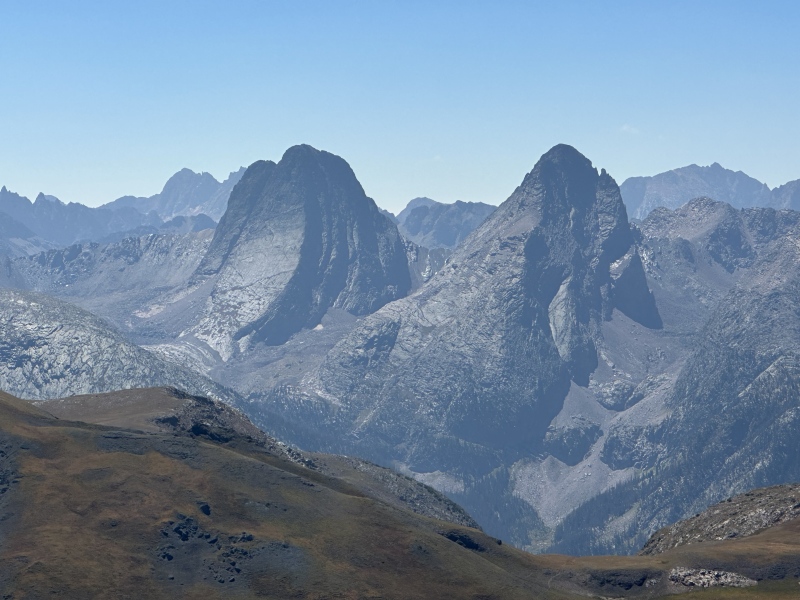
The ridge to Rhoda was short and sweet, with the ever looming views of the Grenadiers growing larger. Vestal and Arrow are seriously impressive. Rhoda’s summit block offered opportunities for scrambling, but can be walked up as well. After climbing what was in front of me I was surprised by a very strange looking sheep. No wait, that’s a dog. And two people! And a second dog. I was surprised, it was the first human interaction I had had all day. They were camped down in the Highland Mary lakes area and decided to hike up Rhoda/Whitehead to enjoy the views. Good call!
After a short exchange of pleasantries I ran away as fast as I could towards Whitehead. I suspected they were disciples of the loaf, and if I had stayed to talk any longer they surely would have seen my true nature. Only my closest friends know that I am but a tortilla disguised as a man. What? The ridge to Whitehead was gentle and short, culminating in a grassy summit with mind-bending views of the Grenadiers. Wow! I took a lot of pictures here while I ate a granola bar.
Astounding.Look more closelier
After relishing in the view I headed down and then up UN 13,117 aka The Ocho. The ridge here is also uneventful, although there is one narrow portion just below the summit. Sweet, 7 peaks and it’s only 12:30! Here I found my first summit register of the day. I added my name and read through the others. Wanting hot food, I didn’t linger long and headed down towards my descent gully. As I neared my descent gully, I spied another which I could see went. I would later be upset to realize that I missed the opportunity to see an open mine shaft at the head of my planned descent gully. Bummer!
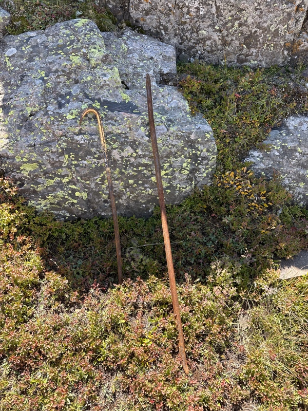
The gully was easy and I headed down grass and scree towards Deer Park and the remnants of the Montana mine. There are some cliff bands and willows to negotiate en route, but I was able to scope a good route by gaining a vantage point atop one of the cliff bands. This kept the willow bashing to a minimum. Plus I found some old mining tools up there, neat!
Said tools
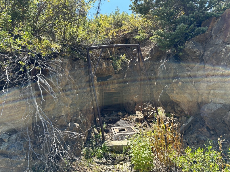
I slunk through gaps in the willows which yielded to open trees. I headed north-NE and eventually intercepted the Whitehead trail just before it terminates at the Deer Park road. After nerding out at the sealed Montana mine I pulled out my headphones. Poor choice there as Spotify served me with some Sheryl Crow, immediately dictating that I run down to my car. Everyday is indeed a winding road. There are a few short uphill portions headed down but the road isn’t bad to run. Plenty of dirt to step on. After leap frogging a Tacoma a few times the driver was kind enough to let me pull ahead, and I got back to my car at 2:45PM. What a stellar day in the mountains.
Sealed entrances to the Montana mine.
My GPS Tracks on Google Maps (made from a .GPX file upload):
Did this route a few weeks after you. Really appreciated your write-up. It was nice to see a few pictures of the section between Kendall Mtn and Peak. It was covered in a bit of snow when i did it, and it was a tad tricky. Found all the same sneaks and such! The headwall isn't as bad as it looks. Nice effort out there! Pretty epic to start and finish in Silverton.
How difficult would you say the traverse between Kendall Mountain and Peak is? Is it super exposed? Could you compare it in difficulty to another route, like Capitol?
Caution: The information contained in this report may not be accurate and should not be the only resource used in preparation for your climb. Failure to have the necessary experience, physical conditioning, supplies or equipment can result in injury or death. 14ers.com and the author(s) of this report provide no warranties, either express or implied, that the information provided is accurate or reliable. By using the information provided, you agree to indemnify and hold harmless 14ers.com and the report author(s) with respect to any claims and demands against them, including any attorney fees and expenses. Please read the 14ers.com Safety and Disclaimer pages for more information.
Please respect private property: 14ers.com supports the rights of private landowners to determine how and by whom their land will be used. In Colorado, it is your responsibility to determine if land is private and to obtain the appropriate permission before entering the property.


")
")
")
")
")
")
")
")
")
")
")
")


