Download Agreement, Release, and Acknowledgement of Risk:
You (the person requesting this file download) fully understand mountain climbing ("Activity") involves risks and dangers of serious bodily injury, including permanent disability, paralysis, and death ("Risks") and you fully accept and assume all such risks and all responsibility for losses, costs, and damages you incur as a result of your participation in this Activity.
You acknowledge that information in the file you have chosen to download may not be accurate and may contain errors. You agree to assume all risks when using this information and agree to release and discharge 14ers.com, 14ers Inc. and the author(s) of such information (collectively, the "Released Parties").
You hereby discharge the Released Parties from all damages, actions, claims and liabilities of any nature, specifically including, but not limited to, damages, actions, claims and liabilities arising from or related to the negligence of the Released Parties. You further agree to indemnify, hold harmless and defend 14ers.com, 14ers Inc. and each of the other Released Parties from and against any loss, damage, liability and expense, including costs and attorney fees, incurred by 14ers.com, 14ers Inc. or any of the other Released Parties as a result of you using information provided on the 14ers.com or 14ers Inc. websites.
You have read this agreement, fully understand its terms and intend it to be a complete and unconditional release of all liability to the greatest extent allowed by law and agree that if any portion of this agreement is held to be invalid the balance, notwithstanding, shall continue in full force and effect.
By clicking "OK" you agree to these terms. If you DO NOT agree, click "Cancel"...
Hidden paths and how to feel like a poser in the Grenadiers
It's late in the year, but I thought I'd contribute a little info from my climbs around Vestal Basin earlier this summer in case anyone else who is NOT an ultra athlete or rock jock ever makes a trip back there. Seems others like me are a dying breed—we've been replaced by better, more efficient climbers. Nearly everyone I ran into was there to either climb Vestal via Wham, or climb the Trinities via 4th/5th class routes. I made my trip over the 4th of July weekend, 2024 during a perfect weather window. I was expecting quite a few other people, which there were. I was blown away by the capabilities of nearly every person I ran into. I didn't think I was old and washed up until this trip. I guess I'm just an old retro grouch now :)
If anyone else wants to follow in my footsteps and feel like a poser among legends, here's what to do:
Pick a busy, perfect weather weekend.
Go by yourself so that any negative thoughts have more time to percolate silently in your head. Pairs well with the misery of backpacking.
Obsessively plan and obtain new gear to lighten your load. Take pride that you got your pack under 40lbs for a measly 4-day trip. Silently grimace when other backpackers make snide comments about how you're obviously not going light, even though that's exactly what you're trying to do. Snarkily remind them you don't have anyone to share the load with.
Hike down the Molas trail with a full pack like the forest is on fire because you didn't budget time well. Get a good set of blisters before reaching the river.
Wave at all the happy trail runners who just completed a 18+ mile day trip to Vestal basin, bagging multiple summits with nothing but a running vest, and wonder how it's even humanly possible to cover that kind of distance with so little food or water.
Pause briefly to wonder if you're making a terrible mistake.
Soldier on with the single-minded goal to make it to a high camp at all costs. Damn the torpedoes (or feet)!
Slog up past all the other campers looking for a perfect marmot-free camp spot until it's too dark to see where you're putting your tent. Pitch said tent on top of tree roots. Ignore the perfect camp spot tucked just out of view in the trees 30 yards away. Filter water in the cold and dark so that you're frozen stiff while strange eyes peer at you from the forest.
Run to your tent so the security of a few microns of nylon protect you from the glowing eyes and eschew eating any kind of dinner to replenish your strength.
Wake up way too late in the morning because the sun doesn't rise in Vestal Basin until 8:30, try to ignore Charlie horse in leg and cramps in foot, put on boots, and hike. Ibuprofen and something resembling food for breakfast.
Hike. Downhill. Back to where all the smart people camped by the trail you actually need to follow. Then, uphill. Like really steep uphill. Ignore blisters, cramps, and wonder why on earth you're climbing at ½ speed.
Hope and pray you run into someone. ANYONE. Because you realize that after 24 hours of being solo, your own company is turning rather surly and the inner peakbagger egging you on is really just a selfish prick trying to ruin your life.
Run into other foolish climbers starting after 8am and realize they're all heading for Wham Ridge. Accept the feeling of failure that as a lowly peakbagger, such objectives are too lofty and you don't have the time, skills, or energy for such tomfoolery.
Slog to summit #1 (Arrow). Obsess over the route since you're alone and imagining your body bouncing down the long ramp is a great way to pass the time.
Meet another climber. Rejoice!
Enjoy the boost another soul provides and share the experience of suffering for self-imposed objectives.
Summit, descend, and relinquish other peakbagger from your methodical pace and set him free.
Slump down on rocks, chew food, and contemplate how your plan will crumble if you don't drag your tired butt up at least one more peak. Hike more.
Realize that you're scrambling up a peak that at least a dozen other people are on, but you're the only fool not climbing solid rock and clipped into a rope as you grind uphill through relentless talus.
Keep climbing.
Climb more.
Summit. Encounter other humans and rejoice again!
Lead strange other humans who can somehow climb up 5th class terrain, yet be trepidatious descending class 2+ down the mountain and relish any moment you're not left alone with the surly peakbagging prick who brought you up here in the first place.
Depart company, wander through rocks, tundra and trees, find hidden trail leading down from Vestal lake right to camp. Collapse.
Remember that you're alone and no one else is there to help filter water, cook, or do anything. Spend all remaining daylight tending to basic needs.
Blow up sleeping pad, break valve.
Sleep?
Ignore alarm. Wake up whenever, because.... tired.
Host internal debate. Participants: one selfish peakbagging prick who MUST summit and complete stupid goals; one lazy bum who doesn't want to move. Somehow the peakbagging prick wins. His plan dictates three summits for the day.
Eat food-like stuff, bandage feet, find miracle rock to cross creek, then bash through willows to hidden trail (look to the white boulder field across the creek).
Follow trail into pretty basin. Briefly enjoy the moment, then look at clock and realize that a snail would have lapped you already.
Encounter crazy human descending cliffs from West Trinity solo and running (RUNNING??!!) across the basin. Say hello.
Wonder what it's like to have that kind of stamina and energy. Ignore feet, legs, and lungs telling you to just lie down and take a 6-hour nap in the tundra.
Climb easy talus. Curse writer who ever said it was easy.
Get horribly off-route and contemplate all the ways to die alone on a mountain.
Drag self to summit, host another debate. Participants: 1 solo climber; tired, afraid. 1 peakbagging prick who has two more peaks to climb.
Allow debate to be interrupted by surprise human appearing from cliffs below.
Assume human must be an angel sent to guide the peakbagging prick and join forces to conquer the Trinity Traverse.
Traverse.
Try not to defecate in pants out of fear.
Summit.
Descend, upclimb, summit again.
Cell service? Where did that come from? Call home and talk to other humans who for some reason encourage this bizarre behavior. Assure them of your safety and relish the brief moment of contact.
Reset attitude. Peaks climbed. Family contacted. Peakbagging prick goes wherever he runs off to hide once the objective is complete. Now I'm just up here with me and some cool dude who saved my skin on the traverse.
Enjoy the view, hike down, and take it all in.
Bash through willows and trees looking for some kind of trail down into Vestal Basin. Find it halfway into the trees.
Meander back to camp.
Tend to basic needs. Wave to the eyes in the forest that haven't eaten you yet. Find amazing camp site 30 yards away and curse as you shuffle around in your tent with a half-deflated sleeping pad that you can't re-inflate.
Climb onto broken sleeping pad and SLEEP.
Ignore alarm again. Leisurely pack up until you're the last human in the basin.
Hike down. Lose trail, repeat.
Reach beaver ponds and swear to never return to this horrid place.
Eat food, swallow miracle pills (Ibuprofen), give up on hiking boots, don running shoes, and get the heck out of here.
Blitz up Molas trail making the best time all trip, feel wonderful.
Reach car, talk with other hikers, reminisce about all the fun that was had, and get sad when you have to leave.
Drive, record notes, drive more, eat, and swear off ever backpacking solo again (the peakbagging prick is a total pill to deal with alone).
Announce plan to family to never backpack alone again.
Wait two weeks.
Start hatching plans for more backpacking.
Stare longingly at pretty photos and recall with nothing but fondness the wonderful experience you had. Ignore all previous resolutions and plan another one!
On a more serious note, this was my first solo backpack. It was harder mentally than I was expecting, and I did myself no favors by wrecking my feet on the way in trying to make up time, then eschewing dinner after the long backpack. Lesson learned. In the future, I'll definitely make more of an effort to ease into it and also find a partner. Next year's objectives include Jagged, Pigeon/Turret, and Jupiter/Grizzly/McCauley. If anyone is interested, please hit me up :)
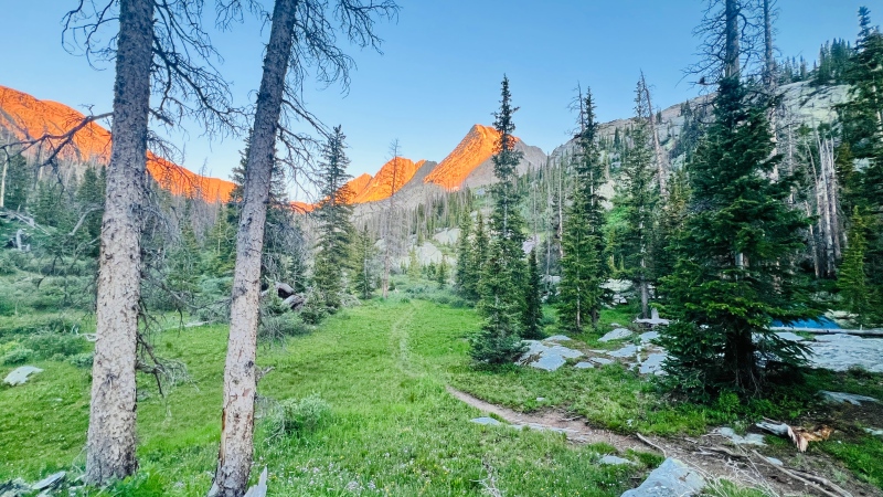
View from camp.
Here are a few notes other peakbaggers may find helpful:
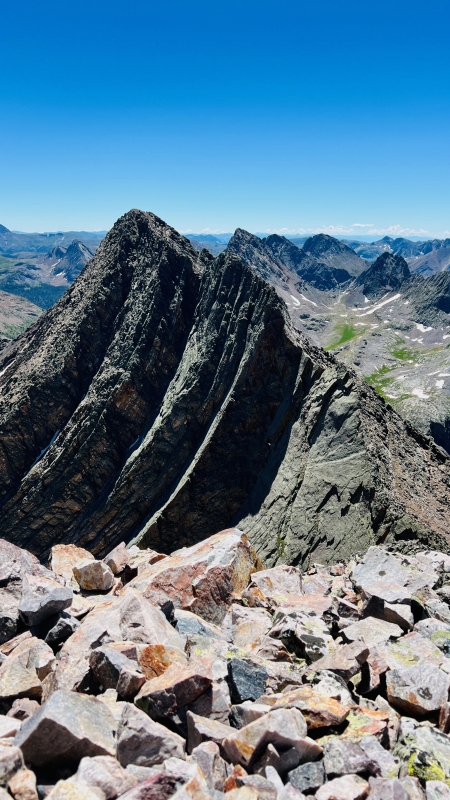
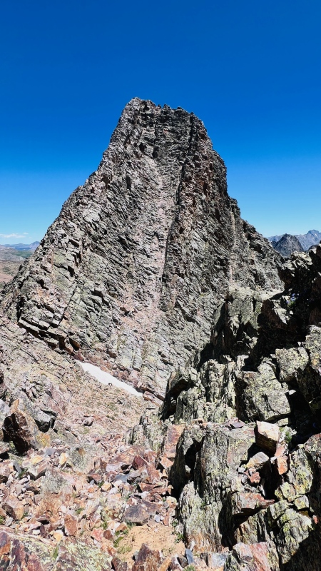
ARROW
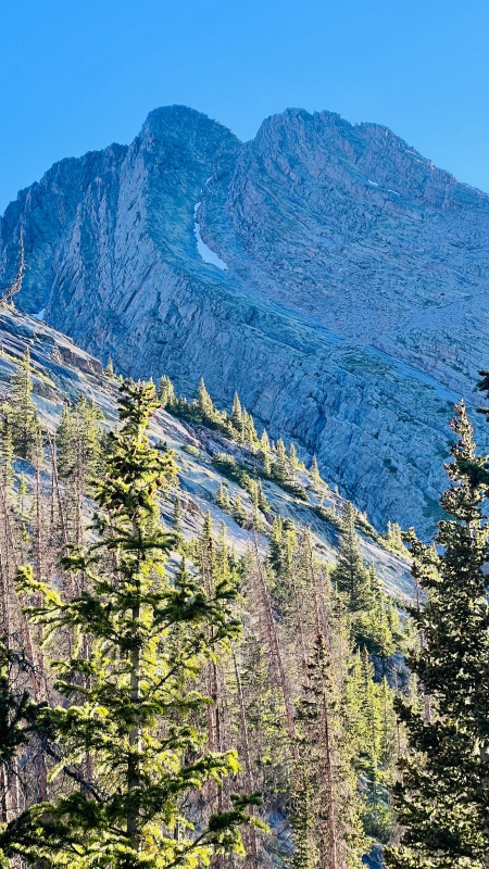
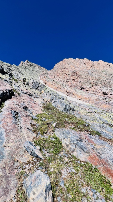
I found the route instructions in Roach's book a bit confusing. There's a simpler way to express the route. From Vestal Basin, Arrow has two fairly prominent ramps that obviously go toward the summit and not past it. Take the large, lower one up until the point the upper one takes off and there's easy access to it. Follow that up more or less on the crest.
View of Arrow from camp. Take the large, main ramp up until the snow. Then take the smaller, secondary ramp above the snow up to the ridge.
The ramps from on Arrow near the point where I started transitioning over to the second, upper ramp.
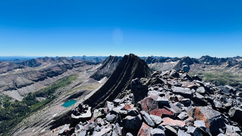
Next objective: Vestal. I was the only person that day who did NOT summit via Wham.
VESTAL
Almost no one seems to climb it via the back side "standard" route anymore. It's not particularly well marked, but Roach's instructions were adequate. Climbers seem to favor the eastern-most options for descending the scree to the saddle, but there's better terrain more to the middle of the saddle between Arrow and Vestal. If climbing up, go that way. If descending, go that way too.
TRINITIES
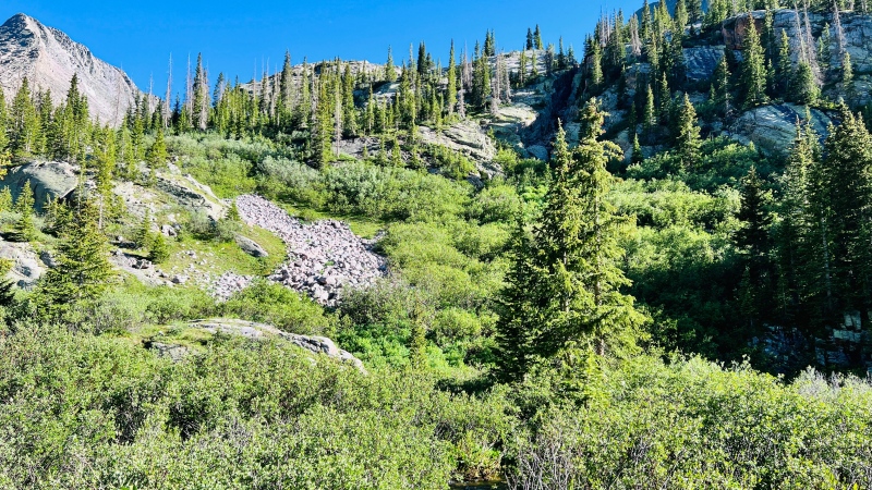
There's a great trail taking off from Vestal Basin that you can use to get into the basin between Vestal and West Trinity, but it's rather hidden to start. At about 11,750' in Vestal basin if you look across to the other side of the creek, there should be a very white looking boulder field. There are cairns around this area that direct to a fairly strong trail leading up through the willows, I assume toward Vestal lake. You can reach the boulder field by either following a sketchy trail out of the meadow to a low creek crossing or by wandering down the creek a bit to where a large rock provides an easy, dry crossing. Once you get to the boulder field, the trail climbs fairly steeply and eventually turns slightly to the west, going by a small tarn nestled amidst some trees. I split off from it around the tarn and was able to meander over toward West Trinity with little problem. I also connected with this on my descent from climbing Vestal.
Head to the white boulder field left of center. There's a trail in there!
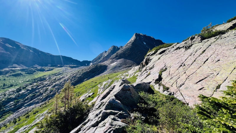
On the way to Trinity Basin.
On the way up West Trinity, I wandered way farther east on the south slopes of West Trinity than I should have. Turns out that's a nice way to keep the route at about class 2. I never ran into anything that I'd call class 3, but it felt long and annoyingly tedious.
Traversing over to Trinity Peak is definitely quite a bit of class 3, punctuated by some solid class 4. I was incredibly glad to not be on this part alone. The moves weren't too bad, but it is exposed (and isolated). The route was fairly well marked, but cairns were sporadic and took some effort to find.
Middle Trinity. Uff da.
The traverse between Middle and East was dicier than I'd expected. The descent was looser and more annoying that I was hoping for. The climb up East was ledgy and involved a lot of class 3. There was also a steep snow gully to cross. I was glad to have an ice axe. Going up East Trinity, the guy I met on the route followed a line more to the right that he said went at easy 5th class. He was a rock jock out looking for pristine wilderness climbs, so he was seeking out that kind of terrain. I was trying to avoid it.
The prominent crack near the right edge goes at 4th/low 5th according the guy I linked up with. I took the chicken route to the left, which was mostly 3rd class. I hate this kind of stuff solo in isolated environments and was thankful to have some unplanned company.
On the descent back to Vestal Basin, just below the large lake beneath the Trinities, there are some of the most beautiful grassy slopes I've ever seen. If you make it into Vestal basin, take the time to come here. It's a magical place.
CAMPSITE
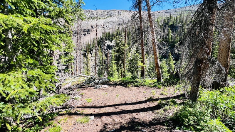
As the Vestal Basin "trail" levels out around 11,750' in a small meadow, there's an excellent campsite hidden nearby. To find it, backtrack to the very small hill you just descended and look for a large tree trunk that's broken off at about 5' height. Opposite of this should be a small rib of rock. Scamper over the rib of rock and generally in a NW direction. There should be surprisingly strong trail nearby leading to an excellent campsite near a small tarn. The deer like this place. If you stay, you'll likely have company—either from them or the marmots.
Hidden campsite around 11,750'
CalTopo Map › (note that my markers were placed when not fully zoomed on Global Imagery. CalTopo has a strange bug where if you zoom in all the way, the imagery shifts out of alignment).
Thumbnails for uploaded photos (click to open slideshow):
Just got back from doing the Trinity traverse a few days ago and I feel this trip report in my soul. Everything hurts and I might be dying but the traverse was amazing. The number of times we said "people do all of this in a day????!" to ourselves was beyond count.
As someone who ran this route in a day in July (well, Vestal-Kurzhorn-West-Middle-East; I did Arrow on a previous trip) I can assure you it isn't any easier, it's just over quicker. The Molas Pass-Vestal Basin approach is much shorter than Purgatory-Chicago Basin (which I've also done in a day, 3 times now.....I should really take the train) but the terrain on the upper mountains is slow and tedious. I got wildly off route on the west side of Trinity Peak and had a few "oh shit" moments trying to get out of that cliff band and back to the sneak above them on the west side. The descent off East Trinity was also way harder than I expected, and the willow thrashing back to Vestal Basin was highly unpleasant. I ended up doing the entire Molas Pass ascent back to the car in the dark and I was out for 19 hours. But it was fun, I guess....?
We found the descent off East Trinity to be incredibly poorly described as well. We got off route (I guess) to the east and I nearly busted my ankle falling/sliding down a crack trying to get back to the ridge and the scree descent.
I thought the whole descent down to that small col (is that Trinity Pass?) would be like it was near the top- tippy but mostly stable talus. I also drifted to the east and I had to traverse-downclimb some of those horrible slabs back to the west to get to the pass. I had no idea there was so much exposure below that section either. I wonder if it's better to descend a ways, then go directly north and down those larger slabs to come right down on the pass. All the trip reports I've read don't really mention any difficulties so perhaps you and I just didn't find the best route.
For doing peaks depends so much on the individual. I'm too slow (especially on more technical terrain) to day trip some of this stuff; but I am a terrible backpacker and really struggle to get any meaningful sleep in a tent. It's a conundrum for sure. After coming away with No Cents on my last 2 Wemi trips I am starting to wonder how I am going to finish the cents.
The dogs and I hoped to do this a couple of weeks ago, but my back was cranky and the forecast wasn't good, and indeed, I'm glad we didn't pack in as there was no weather window to climb. But as a beat up older climber, I can relate to the frustration/envy of having the "younger me's" totally blow past me. (I was fast and agile, - a long time ago.) And I have the dogs with me, so Class 3 or + leads to debates, And with the dogs, packing in less than 40 lbs for 4 days means skimping in other areas. I plan to try this the week after next, back and weather willing, but it will be at my pace. (The eyes after dark don't bother me much, - I have backup.)
57. Announce plan to family to never backpack alone again.
58. Wait two weeks.
59. Start hatching plans for more backpacking.
I was thinking of this very trip for the end of July this past summer but life got in the way and I didn't get it done. Maybe I can enjoy the misery next year!
Thanks for posting!
I'm planning the TT this summer and wondering if it matters clockwise or counter clockwise? Is one way better than the other?
Also can you drive over Hunchback pass and come from the north with a stock 4runner?
Caution: The information contained in this report may not be accurate and should not be the only resource used in preparation for your climb. Failure to have the necessary experience, physical conditioning, supplies or equipment can result in injury or death. 14ers.com and the author(s) of this report provide no warranties, either express or implied, that the information provided is accurate or reliable. By using the information provided, you agree to indemnify and hold harmless 14ers.com and the report author(s) with respect to any claims and demands against them, including any attorney fees and expenses. Please read the 14ers.com Safety and Disclaimer pages for more information.
Please respect private property: 14ers.com supports the rights of private landowners to determine how and by whom their land will be used. In Colorado, it is your responsibility to determine if land is private and to obtain the appropriate permission before entering the property.
")
")
")
")
")
")
")
")
")
")