Download Agreement, Release, and Acknowledgement of Risk:
You (the person requesting this file download) fully understand mountain climbing ("Activity") involves risks and dangers of serious bodily injury, including permanent disability, paralysis, and death ("Risks") and you fully accept and assume all such risks and all responsibility for losses, costs, and damages you incur as a result of your participation in this Activity.
You acknowledge that information in the file you have chosen to download may not be accurate and may contain errors. You agree to assume all risks when using this information and agree to release and discharge 14ers.com, 14ers Inc. and the author(s) of such information (collectively, the "Released Parties").
You hereby discharge the Released Parties from all damages, actions, claims and liabilities of any nature, specifically including, but not limited to, damages, actions, claims and liabilities arising from or related to the negligence of the Released Parties. You further agree to indemnify, hold harmless and defend 14ers.com, 14ers Inc. and each of the other Released Parties from and against any loss, damage, liability and expense, including costs and attorney fees, incurred by 14ers.com, 14ers Inc. or any of the other Released Parties as a result of you using information provided on the 14ers.com or 14ers Inc. websites.
You have read this agreement, fully understand its terms and intend it to be a complete and unconditional release of all liability to the greatest extent allowed by law and agree that if any portion of this agreement is held to be invalid the balance, notwithstanding, shall continue in full force and effect.
By clicking "OK" you agree to these terms. If you DO NOT agree, click "Cancel"...
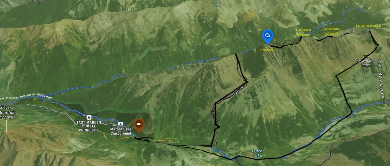
The Grand Pyramidal Traverse(Len Shoemaker->Lightning Pyramid->Thunder Pyramid->Pyramid Peak).
A general route line.
The reason I am writing this trip report is because of the lack of beta on the web on the traverse. I think 7 summits and a few others are a great and in depth, but I just wanted to add my opinion as an extra resource.
In short, this ridge is the hardest day objective I have had in the mountains thus far. I have only been hiking for two years, so my experience is decently limited. My comparable knowledge of technical ridges is only the "4 great traverses".
Ok getting into the meat and potatoes, we started from the car at 4:15 am. Moving up towards West Maroon Pass, you will make a left at a bent tree. It is just past the turnoff for the standard route for South Maroon Peak. The short section on the other side of Maroon Creek is extremely bushwack ish and quite steep, but it only takes 5-10min until you are at the beginning of Len Shoemaker Basin. From here, we continued up until we were below the northeast saddle of Len. It is a quick scree scramble to the saddle, and maybe 3 minutes of class 3+ until we were on the top of Len Shoemaker.
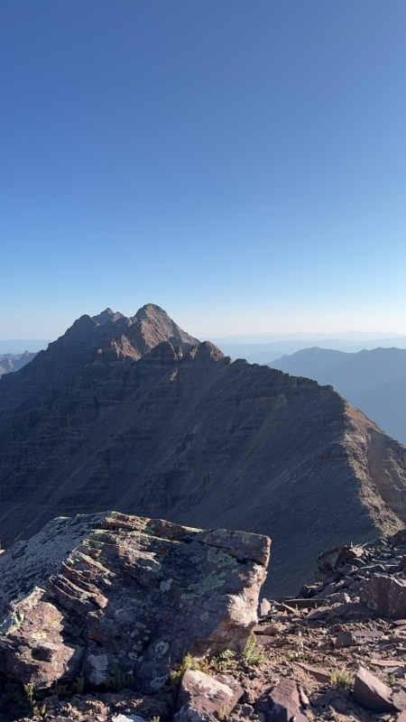
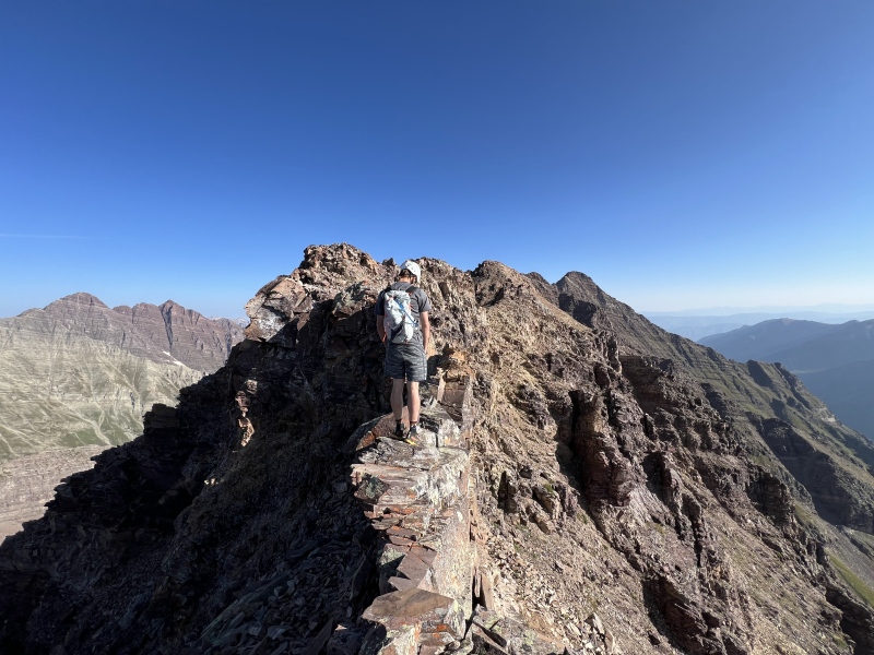
A long view of the ridge ahead. Thunder Pyramid dominates the view, with lightning in the forefront and pyramid as the trailing point.
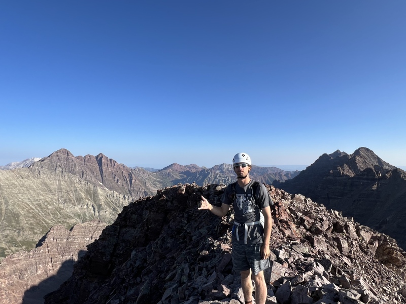
Up on Len!
Moving back down and onward toward Lightning, mostly stay on the ridge direct if possible. The moral of this story is that this route is going to require a LOT of your own judgement and a metric ton of gaining and losing the ridge. I couldn't tell you how many times you will drop down into a little gulley or whatever to avoid stuff you think you shouldn't climb. If you see a 40 ft wall, you can climb it, but I sure am not.
Things to note on this traverse. 1) This is probably the single longest part of the day, it is slow-moving, extremely loose, and tedious. 2) It stays mostly class 3 for the whole way, there is one significant gulley to note before the summit of lightning that is extremely loose. We dropped down into it to avoid climbing the massive tower(pretty obvious) and it SUCKS. Cannot stress this enough this is the worst gulley we touched all day. It is super loose and full of sneaky giant rocks that will fold you. Plant your feet and take it with caution.
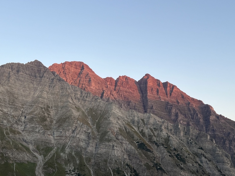
Sunrise on the bells. Wowzers.
Hugging the east side of the ridge when needed and direct when you don't, you should soon be on the summit of Lightning. Woohoo.
This section(between lightning and thunder) is probably the most touched section of this ridge. Notable features on this section is the catwalk, and lots of class 4 ledge traversing. Just like before, stay ridge direct when you can, and east when you cannot.
"Catwalk" more like an elephant walk. Pretty fat and pretty short.
We got off the ridge for a while and then climbed up a relatively solid and grassy gulley on the east side(surprise surprise) and soon we were standing on the summit of Thunder Pyramid.
OK, now here is the most fun, and the most difficult, section of the ridge, traversing to Pyramid Peak! There are some sneaky secrets about this section that are actually different than the rest of the route. Also, it is class 5 whaaaaat.
Ledges.
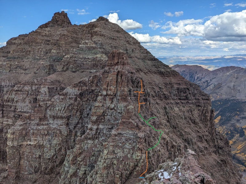
Coming down the ridge is quick, and you will run into fat ledges that go to the WEST(left) so crazy. This is near the unnamed high point. Continue traversing around the left side until you get back on the ridge. You will be doing a lot of ledge traversal for this section, then scramble up and over the top of the ridge. Continue down to the Col(idk if it's a col or a saddle fight me). In front of you will be a gigantic tower that looks decently impassable. Secret tip move around the tower to the left, onto a small dirt ledge, and then go up the class 4 rock gulley thing. Okay next, move around to the right side of the ridge. Here is the 15 foot 5.2-5.3 ish dihedral. Climb it. Now, continue along the right side below the ridge and then climb up one of the later gullies. You will cross through a few before the obviously climbable one that puts you back on Ridge Direct. Now you are staring at your final summit pitch.
The final summit pitch was two, short, but decently technical chimneys that we traversed slightly around the summit block of pyramid to access. I am not totally sure if these were "on-route" of the Northwest ridge, but nothing on this whole traverse felt on route either. Whatever we climbed felt more like a 5.5-5.6 range, so maybe they weren't totally correct, but they went. When you top out you also put your noggin right over the thousands of feet of air that is the eastern face. Super awesome. Then, it's just a few more steps to the summit. Yippee.
Hope this report is decently helpful, I now realize how much information I forgot as I was traversing, and how much harder it is to write one of these than I thought. If you take anything away from this know that this ridge is committing, long, loose, and fun. But, I would not do it again. Cheers.
Thumbnails for uploaded photos (click to open slideshow):
Well done, gents. Too much sketch for me, and your last sentence is telling: "I would not do it again..." But congrats. FYI: For comparison sake, how did this rate compared to the Bells Traverse?
Nice work! I'm super impressed if you found the final chimneys before Pyramid difficult that you were able to get through the Pyramid / Thunder Pyramid saddle climb / headwall with ease. I would very much like to know more as I couldn't follow your text description!! I just traversed from W. Maroon Pass to Pyramid over the weekend and scrambled a lot of those "40 ft walls" to stay on the ridge but even with a bunch of exploring different lines I'd say my climb up the wall from the Pyramid / Thunder Pyramid saddle was 5.6 and it was risky garbage. I think I understand where one line near the top of that headwall reported at 5.4 in other reports is. It looked spicy from below. But your description of the saddle climb at low fifth compared to a mention of those following chimneys along the traverse at 5.6 I'm extremely confused! I stayed on the ridge proper the rest of the way after the headwall and agree on two distinct chimneys - the tan one of solid rock on the climbers' right that was vertical but not exposed and the one of stacked brown blocks with the occasional window through to exposure very close to the Pyramid summit. Anyway, I've annotated where I spent my time back on that headwall searching for an easier route. The dirt saddle is marked in blue, the climbing I consider 5th in orange and 4th in green. Did you touch any of that terrain? Roughly where is the "class 4 rock gully thing"? Thanks and again, nice job and nice report!
Caution: The information contained in this report may not be accurate and should not be the only resource used in preparation for your climb. Failure to have the necessary experience, physical conditioning, supplies or equipment can result in injury or death. 14ers.com and the author(s) of this report provide no warranties, either express or implied, that the information provided is accurate or reliable. By using the information provided, you agree to indemnify and hold harmless 14ers.com and the report author(s) with respect to any claims and demands against them, including any attorney fees and expenses. Please read the 14ers.com Safety and Disclaimer pages for more information.
Please respect private property: 14ers.com supports the rights of private landowners to determine how and by whom their land will be used. In Colorado, it is your responsibility to determine if land is private and to obtain the appropriate permission before entering the property.

")
")
")
")
")
")
")
")