| Report Type | Full |
| Peak(s) |
Gray Needle - 13,446 feet |
| Date Posted | 09/26/2024 |
| Modified | 12/10/2024 |
| Date Climbed | 07/11/2024 |
| Author | Anima |
| Additional Members | Esturtz617 |
| Gray Needle and its Secrets Revealed |
|---|
|
The Story of the Gray Needle: One of Colorado's Greatest Mysteries Above 13,000 Feet
Not so often is a peak shrouded in mystery, especially one that has already seen a first ascent. For the Gray Needle, its early tales bear no living witnesses nor route diagrams. Three separate written accounts exist of the first ascent in 1953, but it is unclear as to what pinnacle they climbed and what they deemed the summit. Due to the peak's solitude along Noname Creek, it’s crumbling walls see little interest beyond the gazes of passing climbers. Few have ever attempted the Gray Needle, and it's unclear if it has ever even seen a second ascent.
The fate of the Gray Needle is tied closely with the waters below it for if the peak wasn't so difficult to access, it may have found more willing climbers, perhaps who could have questioned the then still-living first ascentionists as to exactly what tower they climbed. Without any definite description, the only way to identify the tower is to search for traces left during the first ascent. Fortunately, a series of expansion bolts were employed to reach false summit of the peak, and these bolts, if found, would illuminate the the route of the first ascent and would reveal the tower that they deemed the summit. In this report my purpose is two fold: to provide a general history of the mystery of the Gray Needle and recount our trip that lead to the re-discovery of the bolts some 71 years later after the first ascent. First, however, I must extend my gratitude to the 14ers.com users "BoggyB" (Micheal) and "GoreGalore." The information these two contributed to the mystery was essential to finding the bolts. Had Micheal and his partners not already searched the towers northeast of Noname Needle, I would have focused my efforts in that area rather than the western part. GoreGalore researched and found the original trip report and composed a brilliant forum post on the Gray Needle. I could never match his writing and account of the mystery, so I refer the reader to the forum post for the complete description:
https://www.14ers.com/forum/viewtopic.php?t=60638
Lastly, I must thank my partner Elan. I had tried to go to the Gray Needle alone before, but the climbing was simply too hard and the approach too difficult for me to carry enough gear to solo. My list of partners for this sort of thing is small and Elan was the only one willing to join. I'm not sure he knew exactly what he was getting into, but his patience and resolve where sine qua non to finding the bolts. On the final pitch, it was his idea to courte echelle the difficult crack. Everyone else I know would have favored a decent rather than forcing a way upwards. Without him, the bolts would not have been found.
1953: The First Ascent
In 1953 the American Alpine Club an the Colorado Mountain Club held a joint outing to Noname Creek. At least three different pieces were published from the trip: two were published in the American Alpine Journal, one of which was a a general summary of the outing and another was a very brief description of the first ascent of the Gray Needle. Lastly a substantial trip report was written about the first ascent of Gray Needle. However, this report was unknown until 2021 when a 14ers.com user "Gore Galore" posted it to an online forum.
During the outing, 94 people attended from the age of 7 to 70. The basecamp was established in a meadow at 10,700 feet. This is likely the same general meadow that stretches for three-quarters of a mile and hosts the remains of an old cabin. Three attendees of the trip were Barry Bishop then of Cincinnati, Ohio; Bob Ulmer of St. Louis, Missouri; and David Bidwell of Arlington Heights, Illinois. It was these three men who made the first ascent of Gray Needle. Bidwell wrote the account of Gray Needle:
“The camp was situated about 10,800 feet in a grassy meadow where a number of small streams join to form the main branch of No-Name Creek. Monitor and Sceptre peaks rose above us to 13,700 feet, and we were surrounded on all sides by peaks of 12,500 – 14,100 feet. Certainly a good week's climbing here.”
“That night around the campfire, I heard the name 'Gray Needle' whispered about,- - 'Barry Bishop wants to try the Gray Needle again.' Turned back on this unclimbed peak several days before, Barry was anxious to tackle this tough one again and Bob and I decided to go along. Told that anything would be easy after this one, we decided that it would make a fine conditioner.”
“Off at seven the next morning, 3 hours of hard climbing over boulders and grassy meadows brought us to the base of the Needle and from there we saved time following some easy ledges that Barry had discovered on his descent several days before. By 10:30 we were about 400 feet below the summit and at this point, we roped up, donned rubber soled shoes, and left our packs. Little did we suspect it would be another 8 hours to the summit.”
“The first couple of hundred feet was slow going over crumbly rock, and we spent an hour working our way around the Needle to the point where Barry had previously turned back. From here on we had to fight for every foot. Barry led off on a 60 foot lead, tension climbing almost all the way, using the one small crack that was the key to an otherwise smooth, near vertical face. Unable to belay securely from above, we proceeded with extreme caution and about 2 hours were consumed on this face and in the rotten chimney above. At this point, the 3 of us wedged ourselves between two giant blocks on the sharp summit ridge and congratulated ourselves on a job well done. The rest looked easy. I led on out and much to my disappointment, after turning a corner, came face to face with a 20 foot vertical wall, the only possible route to the summit. Not a crack or a blemish showed itself on the wall. We debated for some time whether to turn back but finally decided that by using 4 expansion bolts and stirrups we might make it.”
“A long 4 hour ordeal, alternating in the stirrups, unable to drill fast due to the exceptionally hard rock and difficult balance, more than once we almost gave up. A broken drill on the second hole dashed our hopes completely. A spare, carried by Bob, revived them again equally quickly. Again we almost gave up when we couldn't get the piece of broken drill out and had to begin the 2nd hole all over again. The new drill dulled fast and we babied it along, praying it would last. Finally, with the last bolt in, I was able to go over the top by standing on the bolt- -the only foothold in sight. The thrill of success was cooled slightly by the fact that we were on a false summit. A fixed rope got the others up the wall and together we moved on to the summit. Dropping down 50 feet, a courte echelle put Barry within striking distance and at exactly 6:30 we reached the top. For a first day's climb, We couldn't have enjoyed ourselves more and we shouted across the valley to companions descending Peak 10 saying we'd be down into camp after dark. We stayed only a moment to enjoy the view and then rapelled off in 3 long 120 foot rappels to the ledges below and our packs. From there we literally ran back to camp until darkness overtook us and forced a slowdown. The thought of a rest the next day kept me going as we stumbled along through the woods and windfall in the darkness.”
After Barry Bishop made the first ascent of Gray Needle, he went on to make the first Ascent—in winter—of Ama Dablam. He also became the second American to climb Mt. Everest as part of the fabled 1963 American Expedition. After reaching the summit he bivouacked alongside Tom Hornbein and Willi Unsoled at 8,500m, losing all of his toes and pinky fingers to frost bite. In 1951, two years prior to the first ascent of Gray Needle, he participated in the expedition that made the first ascent of Denali's now-standard west buttress route, making the fourth ascent of the peak. He died in 1994 in a car crash. Little is known of Bob Ulmer and David Bidwell.
Post 1953: The Mystery Develops
Another Colorado Mountain Club outing was held along Noname Creek in 1960. A feature deemed "Noname Ridge" is listed as having been climbed by 15 people. Noname Ridge is the general ridge like feature that contains both the Gray Needle and Noname Needle. It is unclear which point they reached, but it wouldn't be unreasonable to assume the highest and thus Noname Needle. Gray Needle, given the technical difficulty, was unlikely to have seen 15 people reach the top .
A route description appears for the Gray Needle in the first edition of Robert Rosebrough's “The San Juan Mountains, A Climbing and Hiking Guide,” 1986. Jon Lawyer reports of a climb of “an eighty-foot pitch of 5.5 climbing (that) was encountered just below the shallow col between the twin summits of the Gray Needle.” Lawyer did not see any sign of the expansion bolts placed by the first ascent party. Lawyer, however, did not climb the Gray Needle, Rather, he confused it with Noname Needle, which is now known to be a separate entity.
2012: Steve and Jim
In 2012 as Steve Galdbach neared climbing all of the named points over 13,000 ft in Colorado, him and Jim Dinapoli came face to face with the Gray Needle. However, the pair did not make an attempt to summit the illusive tower, favoring an ascent of the known "Noname Needle" to the east. Dinapoli detailed their thoughts in a report titled "Secrets of Gray Needle and Other Stories." Sadly, both Gladbach and Dinapoli passed away not to long after their trip. This is the first written account where it became clear that the Gray Needle was a mystery. Steve and Jim offer theories as to where the bolts may be located and what the first ascent party climbed, but only in speculation. At this point, it appeared that no one had climbed Gray Needle, nor knew of anyone who had. In the 59 years since the first ascent, the Gray Needle and the 1953 route was lost to time.
2020-2023: Micheal
In 2020, Micheal Davis, who was also close to climbing all the named points over 13,000ft in Colorado contemplated the Gray Needle. In the report "The Real Gray Needle, Noname Needle and The Mystery of the Missing Tat", Davis details the ambiguity present in the USGS maps. He determined that the middle tower (third from west) is the true USGS Gray Needle—that it is the intended named point. During his ascent, he finds no evidence of the aid bolts left by the 1953 party.
In 2023, Davis returned with two partners to search for the bolts. They scoured a prominent tower to the north of Noname Needle to no avail. He also noted that between the three of them, they had climbed every major tower west of Jagged's summit and the bolts had yet to reveal themselves.
2024: The Secrets of the Gray Needle Revealed
Determined to solve the mystery, Elan Sturtz and I were dropped off at Needleton by the Durango-Silverton Narrow Gauge Railroad on the morning of July 10th. Burdened with a large amount of technical gear and four days worth of food, we began the march north along the Animas River.
In the mid 20th century, when train-provided wilderness access was less popular, a series of permanent cables stretched across the Animas near the outlets of major creeks. People and gear could be easily transported to the opposite shore via human-powered tram cars. One such cable existed at the mouth of the Noname Creek and was used during numerous expeditions to the area. The remains of the cable still exist and can be found just south of the Noname-Animas intersection, hanging from an old fur tree.
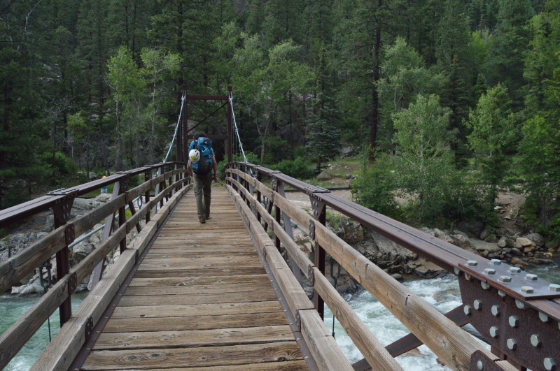
Presently the train regulates wilderness access to Needleton and Elk Park where large bridges provide access to the eastern shores. Noname Creek, two and a half miles north of Needleton, is best accessed via this bridge, with no access from Elk Park. After crossing the bridge, the main trail heads south towards Needle Creek and Chicago Basin. However, a faint trail leads north toward a number of meadows and the creeks north of Needleton.
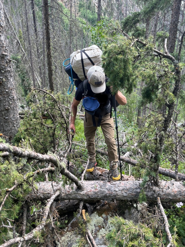
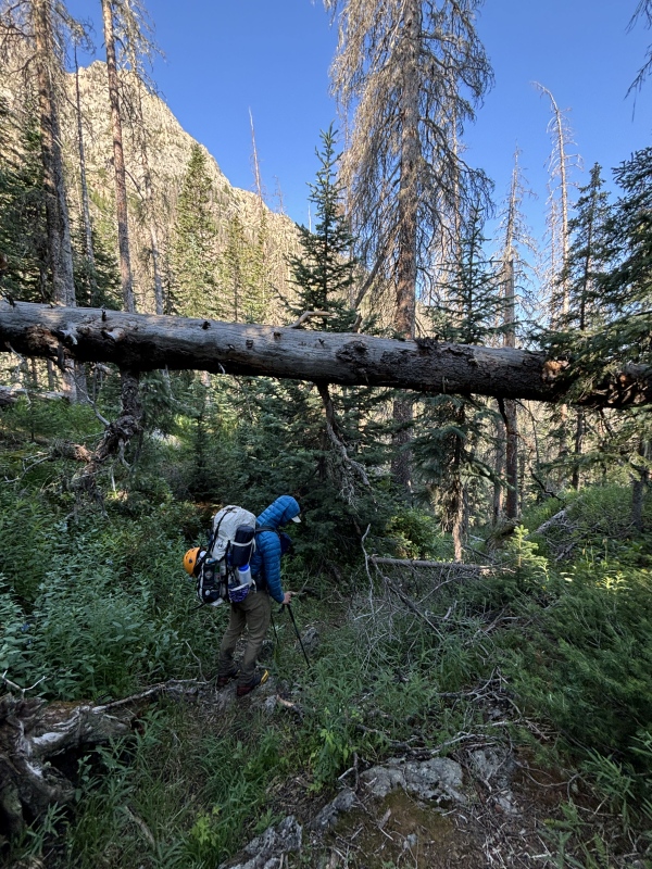
The "trail" along the Animas is primitive and hard to follow, entailing a steep 200 foot climb and decent of the infamous Watertank Hill. If one can tolerate the overgrowth and uncertainty of whether the trail actually exists, they are rewarded with the cold and clear waters of Noname Creek.
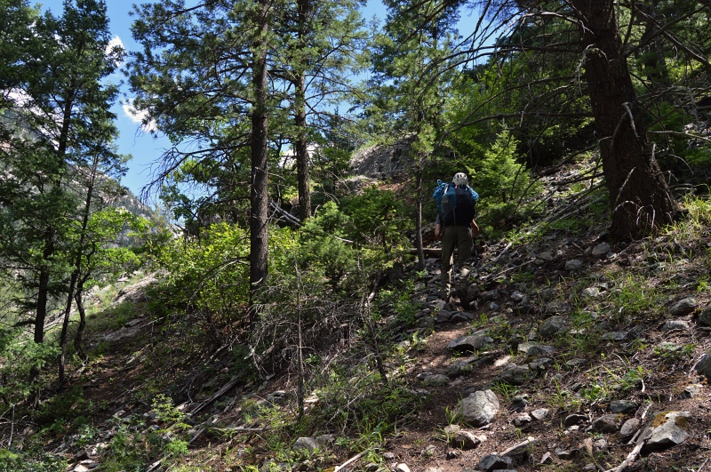
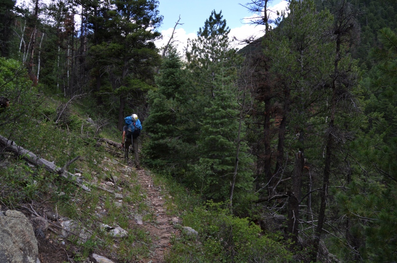
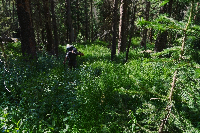
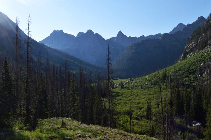
Just north of the Noname-Animas River intersection the old Noname trail takes off east, marked by a small carin. In the subsequent meadow a telephone still pole stands, complete with an insulator. It is a sure indication that one is in the correct spot. The follow six miles into the upper meadows of Noname Creek have a special place in the hearts of many climbers. "Unrelenting" and "unrepeatable" are a few of the terms used to describe the section. The first few miles are on a fairly good, very steep trail—evidence of the large expeditions that took place in the area many years ago. After that the trail fades and underbrush and deadfall obscure all.
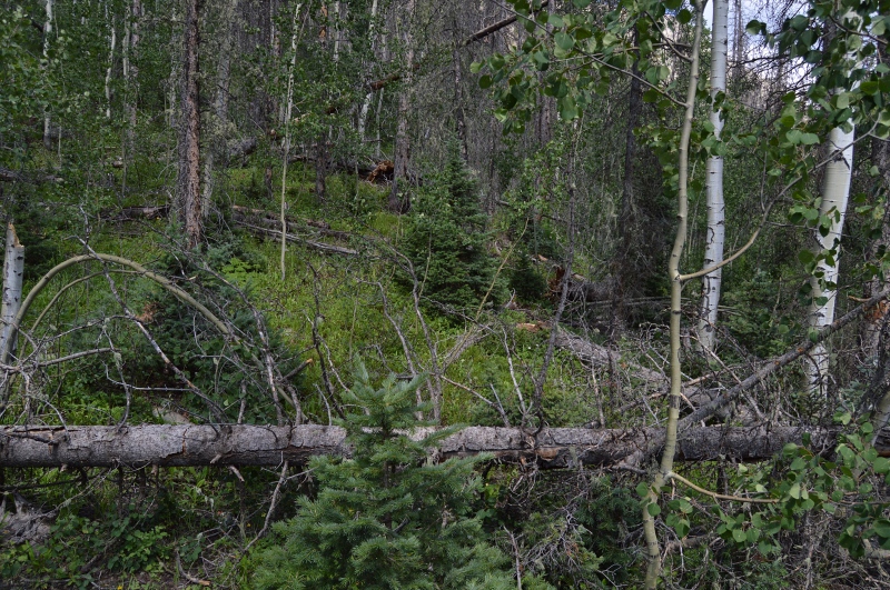
The trail continues all the way to the old cabin in the meadow at 10,800ft, but is incredibly difficult to follow. One closer to the cabin, deadfall takes over with stacks of fallen-logs taller than the average person. Underbrush overtakes the already-faint trail and a keen eye is needed to follow the small indentation. Two new avalanche paths, complete with heinous log piles, provide some of the final obstacles before any respite.
Having fumbled my way up Noname Creek twice before, I have learned where the trail does not go. Using this knowledge, Elan and I slowly made our way up the drainage. In 2016 someone illegally used a chainsaw to clear all of the dead fall of the trail to an elevation of 10,700 feet. In late 2021 or 2022, more clearing efforts were made but only on the lower portions of the trail. There are still 200-some trees to be navigated, a few of which seem impenetrable.
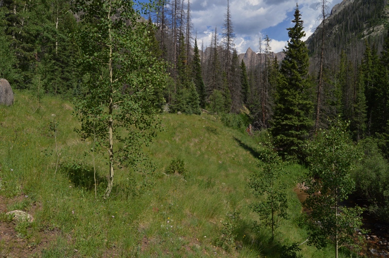
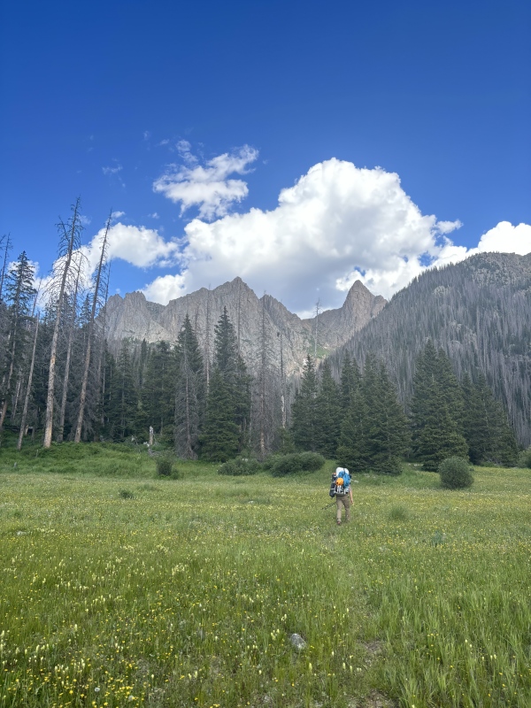
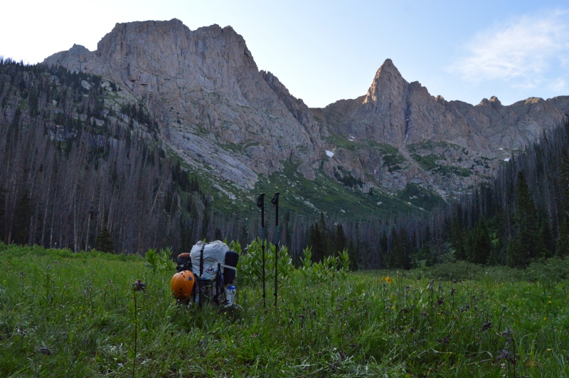
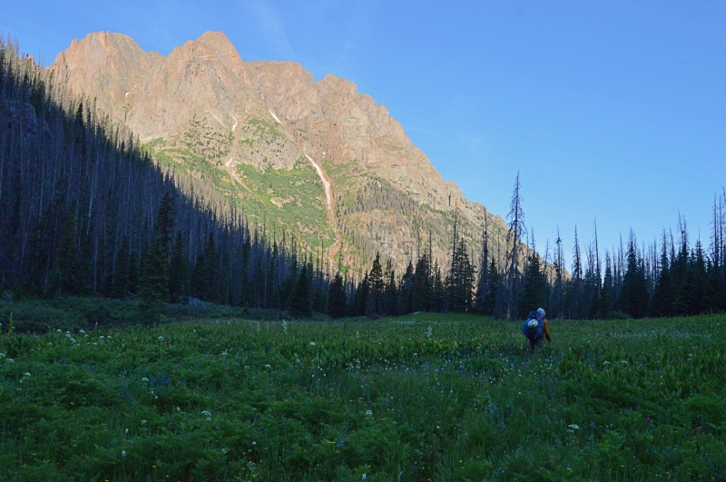
By 5:00pm we found ourselves sitting next to the ruins of Jagged Cabin having survived the toils of lower Noname Creek. Another mile of walking took us to the pristine upper meadow at 11,000 feet where we established camp for the next three nights.
Around dusk a porcupine emerged from the forest on the north side of the meadow. After a quick visit to the river, we found it chewing on a log no more than 15 feet from our tent. Worried it would soon find interest in our gear, we attempted to scare it off to little avail. I was quite on edge given the number of porcupines that have attempted to disable my car at trailheads, but with no one to attend to the camp during the daytime, we would have to leave the tent and its contents under the care of fortune.
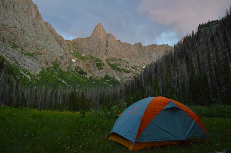
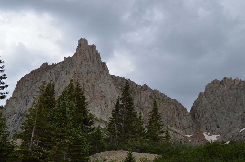
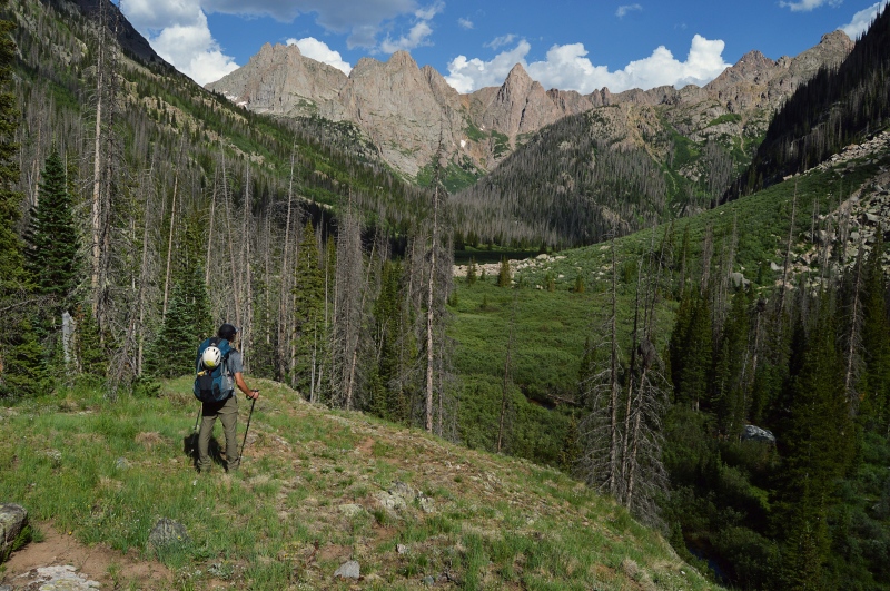
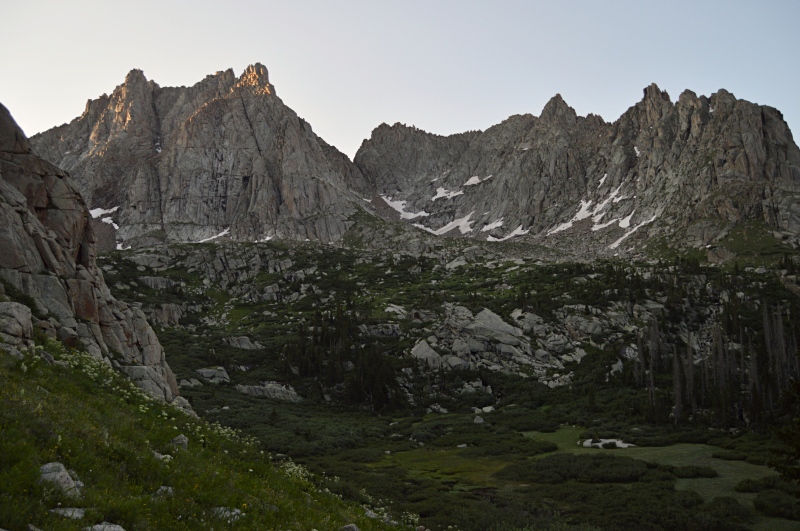
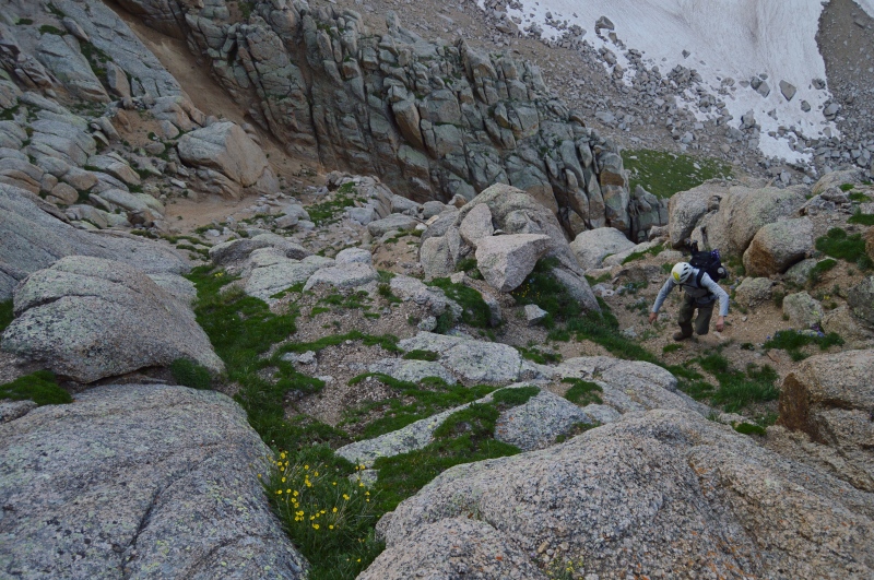
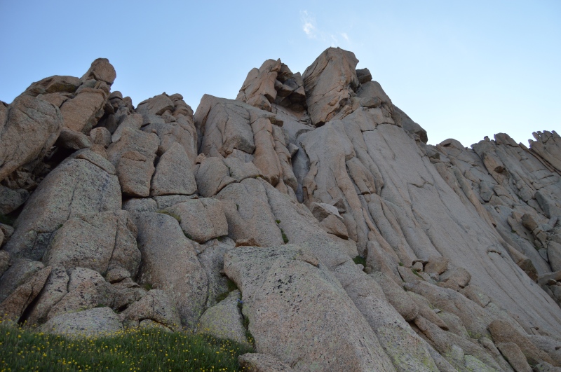
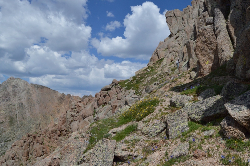
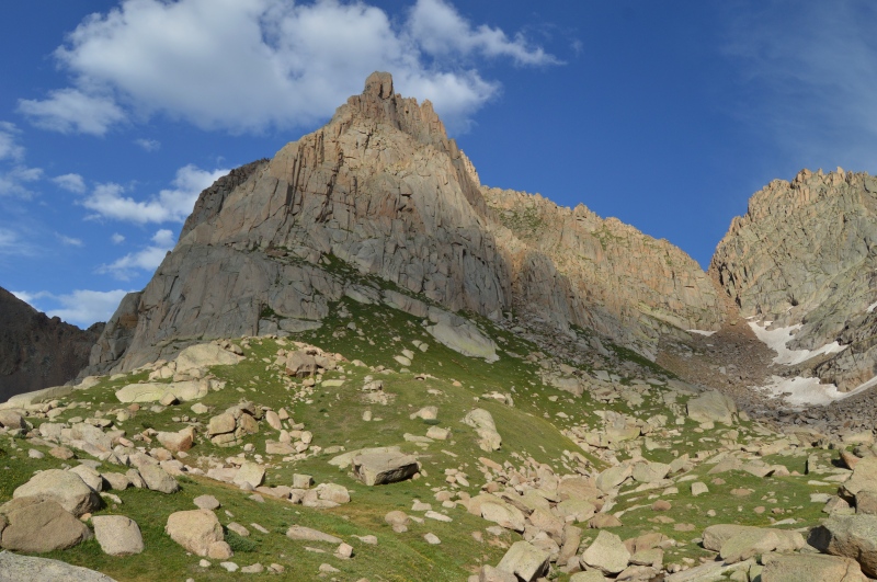
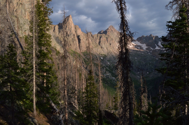
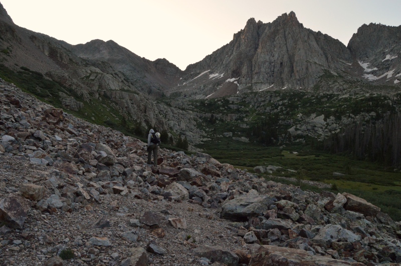
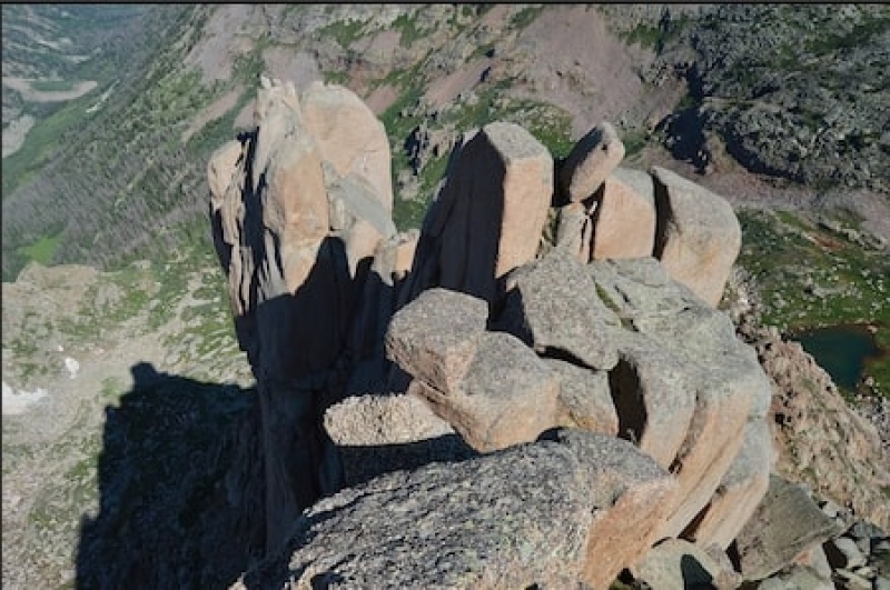
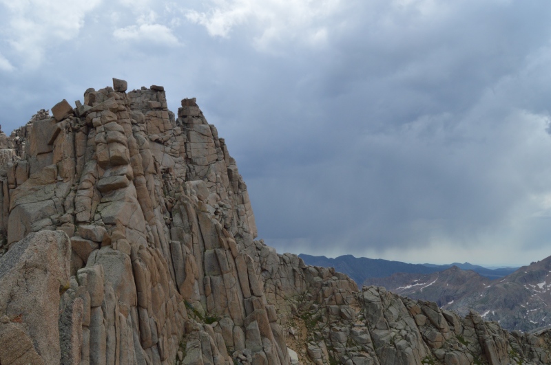
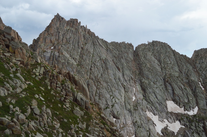
Off at dawn the next morning, we made quick work of the steep section of forest to the marsh at 11,800ft. Skirting along its north side through talus piles and steep grass brought us to the tarn just below the Gray Needle. From this vantage point, the peak intimidates. There appears to be 800ft of scrapy climbing over crumbling ledges to reach the summit towers. However, It's weaknesses are all hidden on the south side where a series of grass-covered ramps provide easy access to the upper reaches.
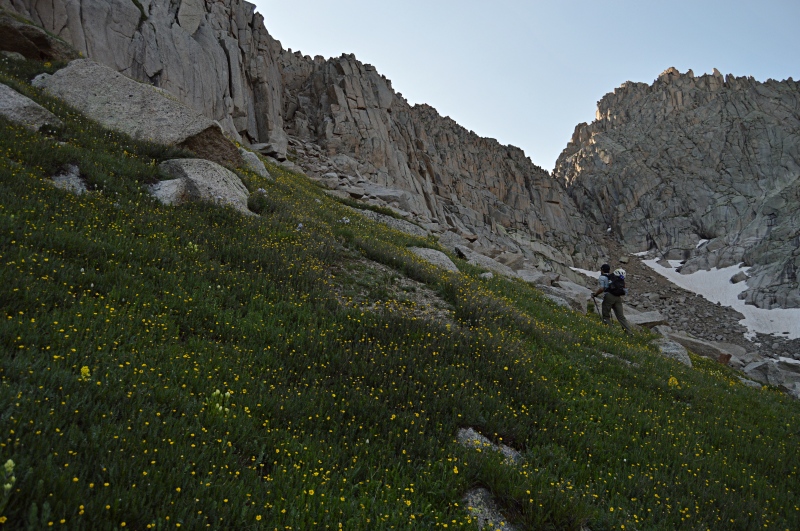
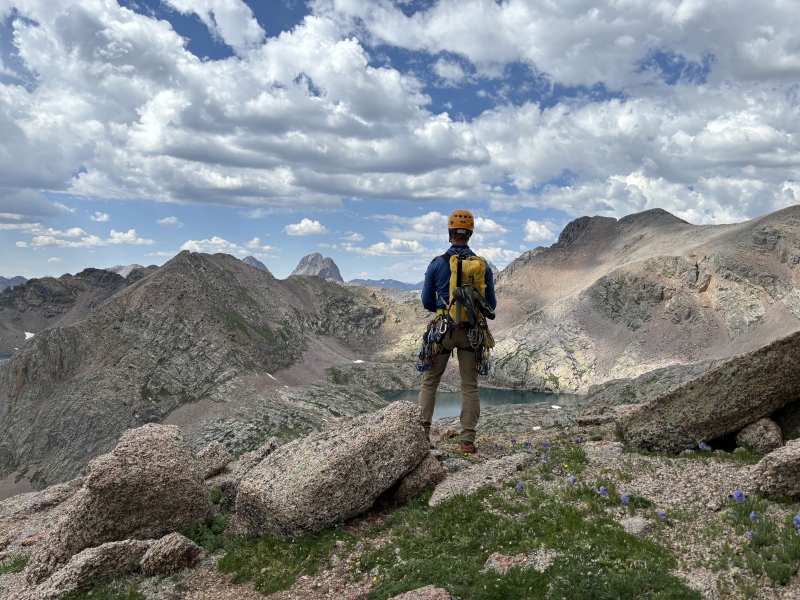
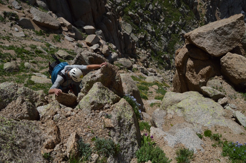
The two of us contoured around the western edge of the wall, where a number of decent looking routes lead upward. Favoring the search for the bolts, we dismissed the tempting climbs and continued working our way toward the weaknesses on the south side. With little information on the area, we found a gully that broke the face and appeared to reach easier terrain above. Figuring it would work just as well as the grassy ramps, a few 5th class moves over a choke stone and many vertical-feet of kitty-litter later we reached the upper slopes to see the easy grass ledges further east. Noting their location and laughing at our poor route finding, we found ourselves on the very upper reaches of the approach ledges with the summit block of the Gray Needle directly above us. Another 50 feet of easy scrambling took us to the final ledge were we roped up and dawned climbing shoes.
While roping up, we found a single black diamond nut sitting on the ledge. It looked as though had someone had placed it there. Both of us were unsure what to make of it given the lack of recorded ascents in the area. BoggyB (Micheal) thinks the nut was left by Steve and Jim. I put the piece on my rack and used it as a rappel anchor later that day on the north side of the mountain.
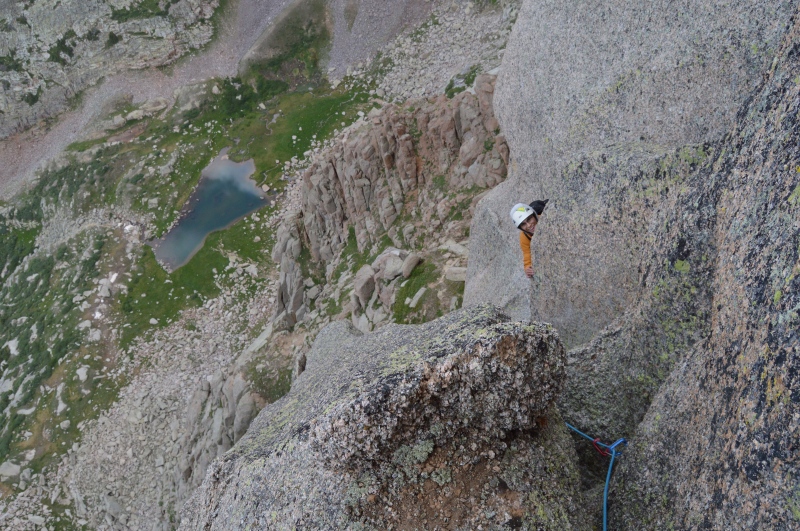
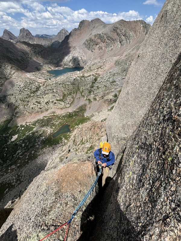
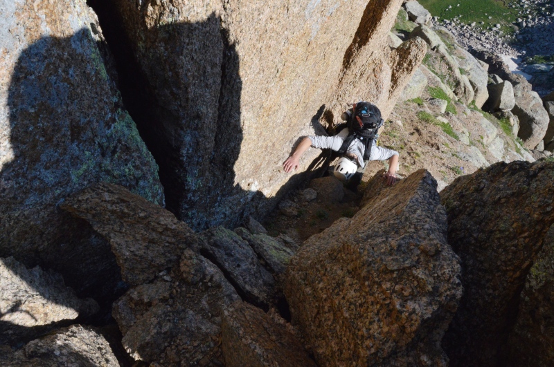
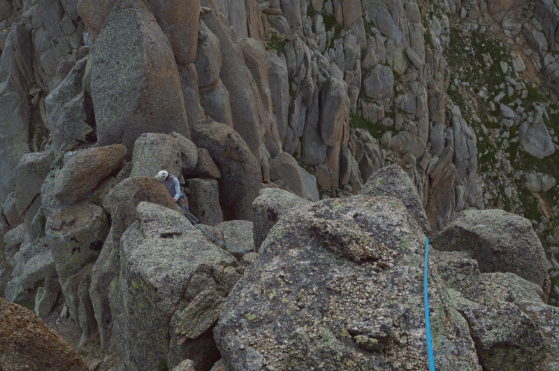
Although Elan is a highly merited rock climber, regularly ticking off grades most of us can only dream of, he has little trad climbing experience, putting me on the sharp-end for the entire trip. A few feet west of our roping-up point, a large chimney took me 30 feet up to another ledge at the beginning of the ridge. Traversing back east across some angled slabs I found myself directly below the bishop. Using a #5 and #2, I built an excellent anchor and brought Elan up.

At the belay ledge we contemplated the remaining climb. A large, off-width crack took off up the bishop, leading toward a narrow ledge with a narrower crack above it. The climbing looked hard and armed with only one big piece which was currently engaged in the anchor, I would risk a serious fall onto the ledge and hope the smaller crack would take smaller pieces. However, the elusive north side of the Needle proved tempting. I doubted the off-width crack was the route of the 1953 party given the difficulties above. A narrow ledge lead slightly downward and around the north side of the tower. Hoping to find easier options and get a glimpse at the elusive north side, I made the traverse. Once onto the north side a small crack lead into a rotten chimney above—in hindsight this was likely the route of the 1953 party. I continued traversing west, climbing up a delicate pile of balancing boulders where rope drag limited my exploits. A few moments later Elan joined me at the new belay.
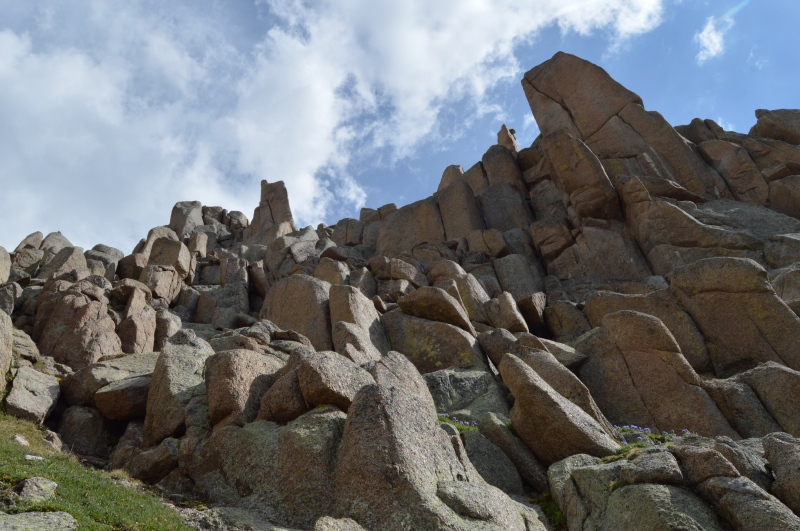
Two cracks took off above us, but neither appeared easy. Knowing the true summit of the bishop was still to the east, I contemplated more traversing. However, an awkward slab with limited exits foils my plans, and the two of us are left to ponder the options just above our belay. The rock is crumbly and what lies above is uncertain, but it appears they will provide access to featureless face near the summit of the tower—a place where aid bolts might prove useful.
Building a new anchor in one of the cracks, I am unable to free climb the lower moves, risking yet another awkward fall back onto the ledge. Somewhat disillusioned, Elan offered to stand on my shoulders and sink a nut in the finger sized crack above. I gladly accept and five minutes later we have an excellent piece to protect the lower moves. The finger crack above fails to inspire confidence with all of the little texture-providing crystals failing at the slightest force. I aid five feet of the crack on a few cams and nuts before it roles over into a featureless bulge and a ledge above. Spreading my body out to provide as much friction as possible, I swam and floundered my way onto the ledge. Hoping the greatest difficulties were behind me, I set off upward into a series of cracks and chimneys that would constitute the scariest 25 feet of climbing of my life. Nothing was to be trusted, pieces of the mountain failed at the slightest touch. I spent a long time balancing my way up this crumbling chimney.
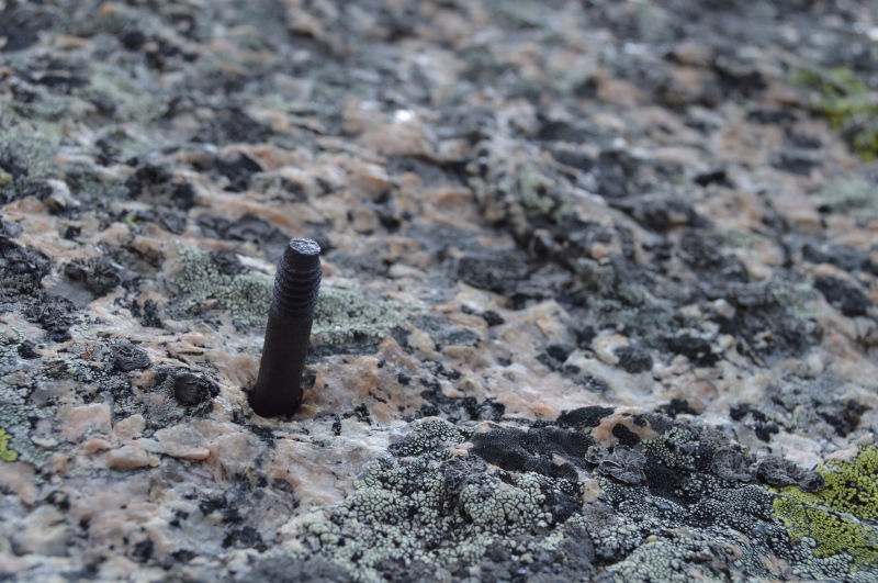
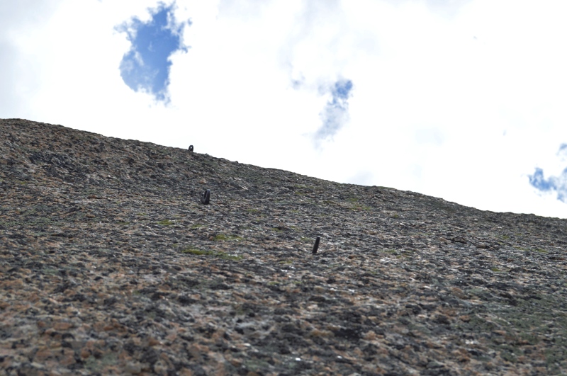
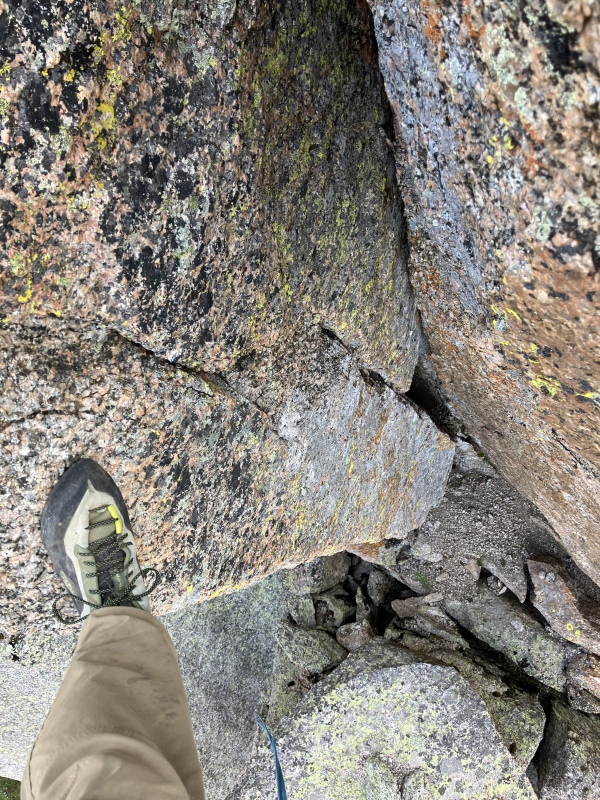
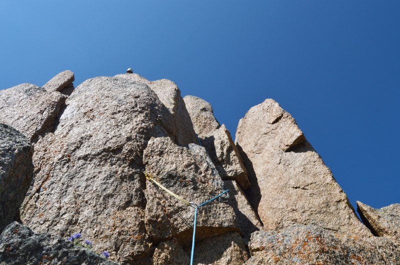
After lots of soul-searching I found myself five feet from a large ledge where I would be able to build an anchor and get the hell off of this thing. I had nearly forgotten about the search for the bolts. A few moves of disgusting pressure climbing later, I pull myself onto the ledge just in time for the only handhold to fail. I stood up, and looked around. To my disbelief, the bolts loomed directly above.
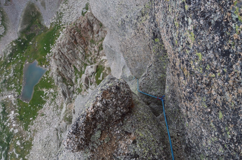
The rusted edges of the old bolts broke apart an otherwise smooth face. The bottom two were missing their hangers while the top two appeared to be completely intact. I shouted down to Elan in pure excitement. At first, he didn’t understand me and just heard screaming from above. Sure that I had found my way into some predicament—having finally reached my limit on the crumbling face—he braced to catch a large fall on very questionable gear. It wasn’t until I came over the radio with the fact that I had found the bolts, and that such a revelation was the origin of my excitement, that he too became excited.
I quickly slung a massive block on the ridge using cord (a 240 cm sling was too small) and backed it up with a cam in a crumbling crack above. Soon enough Elan was on his way up. After aiding a few moves lower down Elan was greeted with the final crux of the pitch where I had left no handholds. By pulling on the rope he joined me on the ledge where we both took stock of our findings. Elan described the climb, especially the final crux, as “canyoneering” with some decent climbing lower down. I couldn’t agree more. The final grade we gave our route to the bolts was 5.9 C1, 3 pitches.
We spent a moment enjoying our revelation. For that moment, we were the only two people who knew the secrets of the Gray Needle A work, a mystery, in progress… completed. I sent a message to my good friend Kyle (known as shepherdkyle on 14ers.com) that we had found the bolts and they were located on the western-most tower—the one Steve and Jim had speculated about all those years ago.
I climbed up onto the highest ledge and reached up to touch the remainder of the first bolt. The rusted metal was still threaded and it seemed to be in good condition, lest its missing hanger. Giving the crumbling nature of the rock (many, many large flakes were loose on the sharp summit ridge we were perched on) Elan opted to observe the bolts from the anchor below.
For a moment the two of us thought about trying to use the bolts. Such labors would require us delicately hang carabiners from the remaining bolt stubs and hope they wouldn’t slip off, or try to rodeo clip one of the higher bolts. The former seemed dubious and the ladder risked the destruction of fragile history. Happy with our findings, we decided to head down and explore routes to the summits further east. In the moment, we speculated that the fourth tower (or one tower east from our location) was the point the first ascent party had deemed the summit. But after conversations with BoggyB, (Micheal), it is likely that the true summit block of the Bishop, just above the bolted slab, was what they deemed the summit.
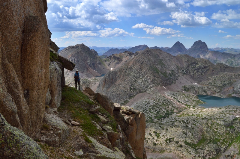
A 90 foot rappel took us to an overhanging, slanted crack where I built another anchor. 50 feet below brought us back to the approach ledges on the north side. Wondering if the ledge was a continuum of the ledges on the south side, I walked to the western apex where there was a large flat area and the southern approached ledges became visible. Knowing we could simply walk off from this point. Elan and I turned our attention to the second western-most tower, or what we had thought to be the true summit of the Gray Needle.
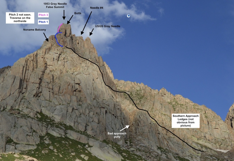
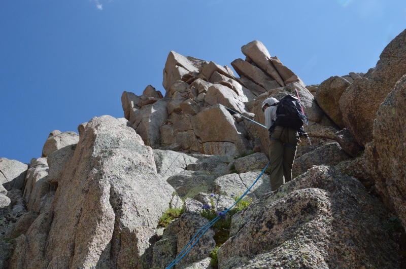
At this point it was midafternoon, but the weather seemed to be holding. A few clouds were building so we headed east toward the fourth tower. A few hundred feet of grass ledges and 4th class scrambling over crumbling rock brought us close to the saddle between the 3rd Needle (the USGS Gray Needle) and the 4th Needle. In the few minutes it had taken for us to reach this point, a storm was building violently overhead. Being so close, we decided to see if the weather would hold.
From our point close to the saddle, I started traversing back west toward the summit of the further needle. A mere 40ft from the top and 20 minutes from our fair-weather stance on the approach ledges, I began to hear buzzing coming from the needles to the east. Burdened with a large amount of metal gear, a position high on some granite towers is not a pleasant place to be in an electric storm. The buzzing sent the two of us scrambling back to the approach ledges lower down. Sure enough, the sky’s began to rumble as we began our feverish decent.
Back on the south side of the Gray Needle, we took shelter under some cliffs. With good weather to the west, we thought another attempt at the fourth needle might be in order. 20 minutes of waiting and the skies cleared. We made our way back to the western apex of the approach ledges which we deemed “Noname Balcony” for its position overlooking Noname Creek. Not sure if the weather would hold and on edge from the electricity before, we decided to call it for the night, stashing all of the technical gear on the balcony. On our way back, we went around the south side of the marsh at 11,800ft through pleasant forest with minimal deadfall (for the area.) That night back at camp we enjoyed a pleasant fire, an orange sunset, and another visit from the porcupines.
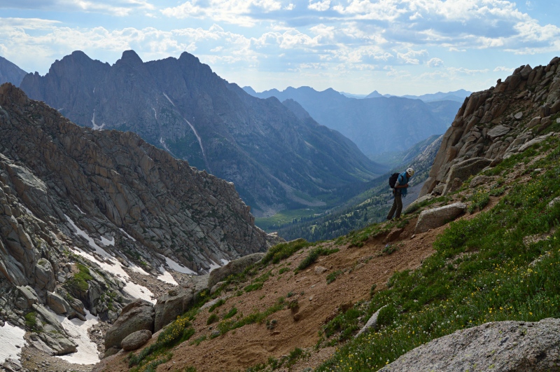
Up just before dawn the next morning, we made the lonely commute back into the basin between Gray Needle and Peak 10. By 8:30 am we were back at our high point on the fourth Needle.

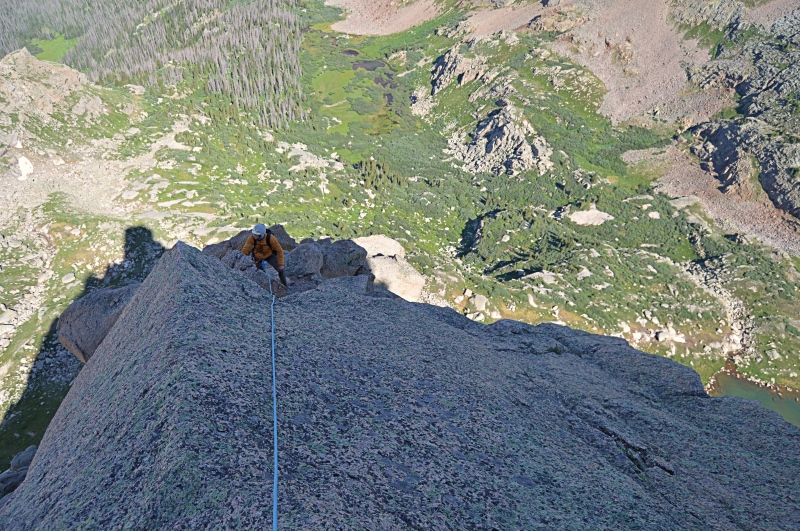
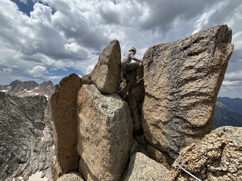
I lead off and only encountered crumbling rock for the last 20 feet. Protection was good and a #3 proved useful for the final moves onto the summit. The top was just large enough for one person to stand on, so Elan lowered me down and then I belayed him up. There was no good anchor on the summit and not wanting to leave my #3, Elan down climbed on belay while pulling gear. This tower is considerably easier than anything on the Bishop, a mere 40ft 5.4 pitch.
We thought about exploring routes to the true summit of the Bishop, but with weather building we opted for an ascent of the USGS Gray Needle via the 5.6 Route described by BoggyB (Micheal). Back on the south side we made good time scrambling up to the southern slopes below the lizard head. I took off on lead and a few fun chimneys took me 40 meters up where I built an anchor. Another few fun moves to the ridge brought me to the summit block where I found webbing and a summit register. We took turns signing the register, which had signatures from Micheal's Party in 2020 and another group in 2023. This Needle was also considerably easier than the Bishop—the two of us never even put on climbing shoes. It is a worthy scramble that goes quickly. I agree with their rating: old time 5.6 / v0. 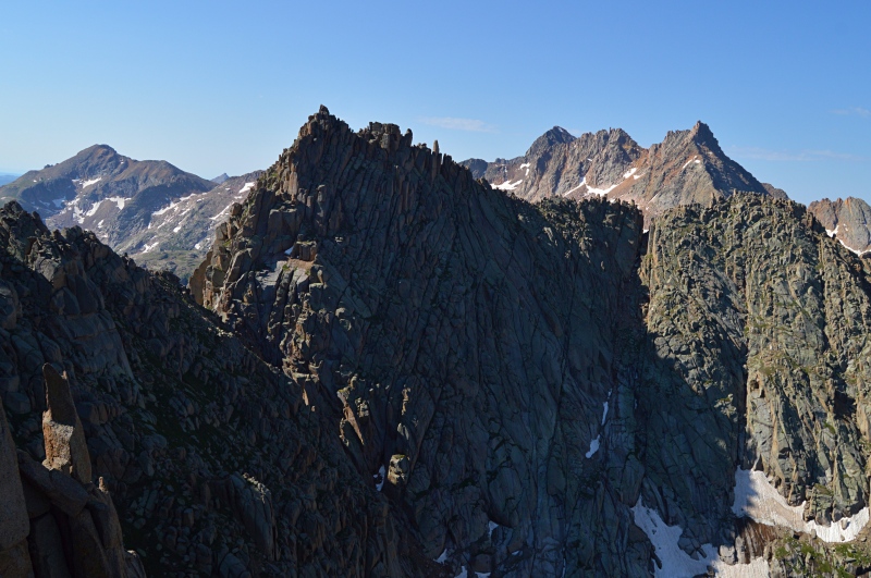
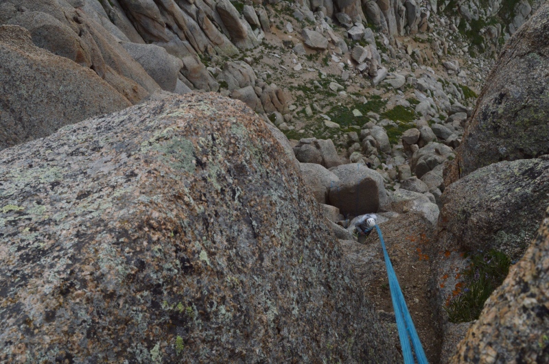
At this point significant storms were building. Two rappels brought us back to ledges were we descended into the basin. Thunder boomed directly overhead as we moved for the trees. Following our route from the day prior, were we found our way around the south side of the marsh, we made it back to to camp just in time for the rain.
The porcupine once again joined us for dinner. At 7:00am the next morning we had camp packed up and were making our way west toward the Animas River. Having not seen a single person since we left the train station four days prior there was a sense of melancholy as we made our way back toward society. By 11:00am we were back at the Animas and by 1:00pm we were walking across the Needleton bridge, carrying the secrets of the Gray Needle.
Thumbnails for uploaded photos (click to open slideshow): ")
")
")
")
")
")
")
")
")
")
")
")
")
")
")
")
")
")
")
")
")
")
")
")
")
")
")
")
")
")
")
")
")
")
")
")
")
")
")
")
")
")
")
")
")
")
")
")
")
|
| Comments or Questions | ||||||||||||||||||
|---|---|---|---|---|---|---|---|---|---|---|---|---|---|---|---|---|---|---|
|
Caution: The information contained in this report may not be accurate and should not be the only resource used in preparation for your climb. Failure to have the necessary experience, physical conditioning, supplies or equipment can result in injury or death. 14ers.com and the author(s) of this report provide no warranties, either express or implied, that the information provided is accurate or reliable. By using the information provided, you agree to indemnify and hold harmless 14ers.com and the report author(s) with respect to any claims and demands against them, including any attorney fees and expenses. Please read the 14ers.com Safety and Disclaimer pages for more information.
Please respect private property: 14ers.com supports the rights of private landowners to determine how and by whom their land will be used. In Colorado, it is your responsibility to determine if land is private and to obtain the appropriate permission before entering the property.


