| Report Type | Mini |
| Peak(s) |
Uncompahgre Peak - 14,318 feet |
| Date Posted | 08/18/2024 |
| Date Climbed | 08/18/2024 |
| Author | Ptorstadactyl |
| Uncompahgre with a Bike Approach |
|---|
|
My Dad and I knew we wanted to climb Uncompahgre, but since we no longer have a 4WD vehicle, we were somewhat stumped on what to do, as the lower trailhead would lead to a 5,500 vertical day, which he was not willing to do. However, our solution was to bike up the road until the upper trailhead, where the wilderness started, and hike up from there. This is that story. We pulled up to the lower trailhead and started riding uphill at 6:30. It took us an hour and 36 minutes to pedal up to the upper trailhead. We do have plenty of experience riding uphill, having both done the Mt Blue Sky hill climb earlier in the year (6,600 vertical), and my dad had done the Leadville 100 MTB race the previous weekend. We were also on downhill mountain bikes, so the bumpy road wasn't much of a concern. Suffice to say, we were prepared as far as gear and physical shape went. The road was steep, and quite nasty. We were very glad to have left our Subaru Outback at the 2WD trailhead. The 4 miles, 2,500 vertical of climbing was tough, no doubt, but also definitely quicker than hiking, and likely about the same effort. I spent a majority of my time in my second to lowest gear, with many times dipping to the lowest, and a few times getting off and pushing the bike, just to get a rough idea of what it was like pedaling up. There were two creek crossings on the road up. The creek was definitely fuller since it had rained a bunch the night before, so it may not be much of an issue this time of year under normal circumstances. I'm imagining this is about what the creek would look like earlier in the summer with snowmelt. I wish I had snagged a picture of the route I took through the first, which was the trickier of the two. Since we had a long day of hiking ahead of us, I didn't want to get my socks wet already, so I picked up my bike and carefully walked across the rocks that either poked up or were barely submerged along the uphill rider's left side. It was a little sketchy, but I made it across with dry feet. My dad chose to pedal straight through the water, getting his feet a bit wetter than mine, but taking a fraction of the time. Either way works, make your decision based on timing and personal preference. 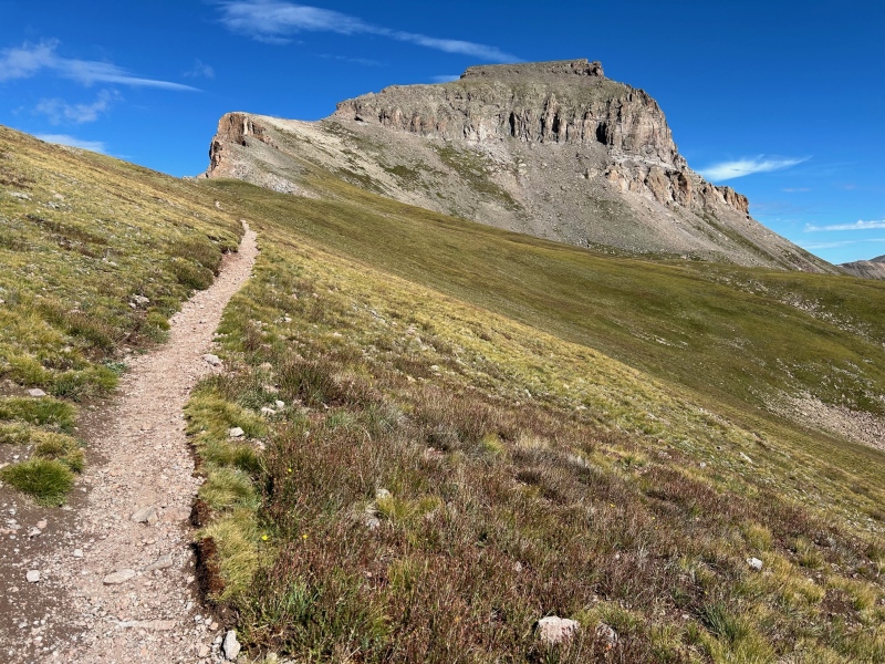
Once the ride was over, it was time to hike. We locked the bikes up at the trailhead, and began the adventure. The trail is beautiful, but uneventful, all the way until ~13,800 ft. This is where the trail crosses over the ridge to the west side of the mountain, after a face of some switchbacks. It was class 1 climbing until here. This part is definitely the crux of the route, just as the website says. It becomes loose talus in the blink of an eye, and suddenly you are traversing across some rock that really wants to slide. We took the route beyond the rock tower noted on the main page (which by the way is visible the moment you cross to the other side of the ridge, this just caught me by surprise). In my opinion, the climb to the stable ground above this rock tower was a very difficult class 2 rating. It didn't last for too long, but I was genuinely concerned that I was going to start a rockslide. My dad waited on the other side of the rock tower while I ascended, just in case I knocked a bunch of rocks loose. There wasn't much exposure, but it was just surprisingly steep, and really, really loose. I can see why the 14ers website calls the whole route class 2, as it is extremely chill until this one spot, but I wasn't too convinced when we were on the slope. It isn't class 3 though. I think pretty much anyone could do it, provided they take their time, test every rock, and stay far enough apart to not knock rocks on their friends. From the top of this, it is still surprisingly far to the top, but easy class 2 with a decent trail. 
All told, it took us from 6:30 until 10:40 from lower trailhead to summit using our method. Storms were coming in real fast, so we hightailed it out to get off of that one spot before it got wet (and it was surprisingly easier on the way down than the way up, which I was not expecting). From there, we got back to the car by 1, owing to the very nice trail, and of course flying down the road on our bikes. The only downside was getting extremely muddy, but hey, that's the sign of a good time. Since I didn't drive the road, I can't comment exactly on what vehicles could or couldn't make it. All I'm going to say is that I was very glad to have not attempted it in our Outback, and there were some spots that I felt like I was downhilling at Trestle Bike Park on the way down (I have been downhilling for ten years btw). If you are going to attempt the road, read trailhead reports, watch videos, and really know what you are getting into. 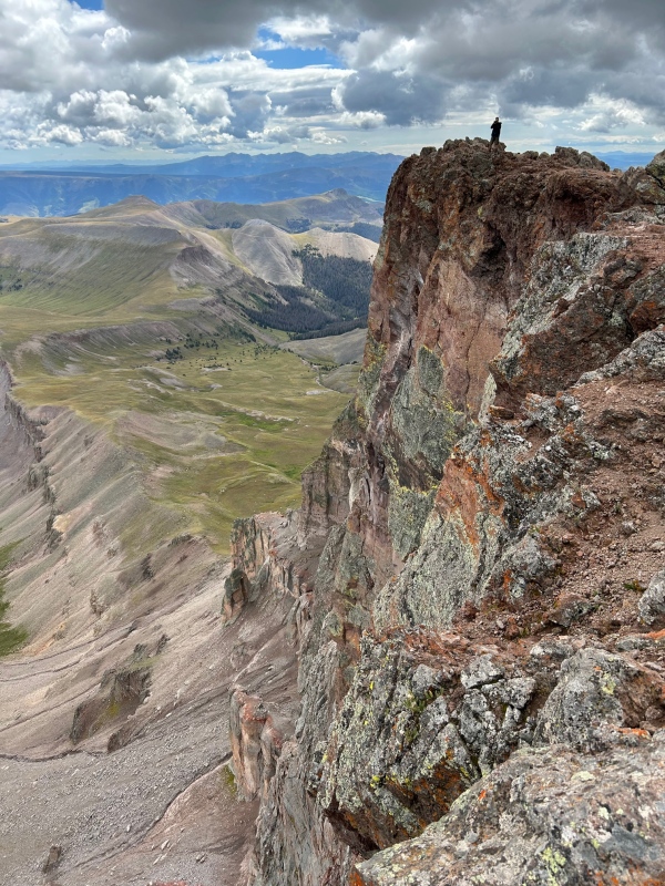
Out of the 21 14ers I've climbed, this was my favorite. This mountain is so beautiful, and the views are absolutely incredible. Be cognisant of the fact that you will be the tallest thing around for 80 miles, and while that is extremely rewarding, it also raises the stakes. Be smart with the weather, and don't get injured, cause I'm pretty sure the nearest hospital is in Gunnison. If you do not have a 4WD vehicle, I would highly recommend what my dad and I did today using a bike. Have fun, and hopefully this was helpful! Thumbnails for uploaded photos (click to open slideshow): ")
")
")
|
| Comments or Questions |
|---|
|
|
Caution: The information contained in this report may not be accurate and should not be the only resource used in preparation for your climb. Failure to have the necessary experience, physical conditioning, supplies or equipment can result in injury or death. 14ers.com and the author(s) of this report provide no warranties, either express or implied, that the information provided is accurate or reliable. By using the information provided, you agree to indemnify and hold harmless 14ers.com and the report author(s) with respect to any claims and demands against them, including any attorney fees and expenses. Please read the 14ers.com Safety and Disclaimer pages for more information.
Please respect private property: 14ers.com supports the rights of private landowners to determine how and by whom their land will be used. In Colorado, it is your responsibility to determine if land is private and to obtain the appropriate permission before entering the property.

