| Report Type | Full |
| Peak(s) |
Grays Peak - 14,275 feet |
| Date Posted | 07/28/2024 |
| Date Climbed | 07/23/2024 |
| Author | RichardHallKY |
| Grays Peak - Ordinary Dude! |
|---|
|
I am a 38 y/o male from Kentucky who hiked Grays on 7/23 with several friends. I have no previous experience with elevation or hiking long distances. I am 5'11", 230 lbs, and probably considered below average in physical condition. I can hold my own in a friends/church volleyball or soccer game, but no one would ever look at me as "athletic" or in "good shape". I say all this personal information for your context of my experience. We arrived at 6am on Tuesday July 23rd. We had two cars and both were able to park at upper lot, with a few more spots available. Plenty of road parking was still available. Facilities in parking lot are adequate with a single toilet. We started the trail around 6:15am. The first mile is a steady incline that whooped my butt. I was not proud of this, but I had to ask the group to stop for breaks about 30 minutes into hike. I realized quickly that I was not in the proper shape to do this hike, which was exclusively my fault. My biggest recommendation is to go at your own pace from the very beginning. The group I was with was definitely going faster than I personally should have been going. One item that struck the group was how quickly you get above the tree line on this trail. It felt like we were out of the trees within the first hour, so you spend the rest of the day completely exposed to sun. The sun rises behind you as you start the trail and illuminates the mountains ahead. Somewhere around the 1 mile point you turn a corner and can see both peaks up ahead. Grays is a rounded top mountain on the left and Torreys is much more pointed on the right. 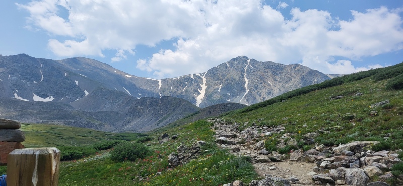
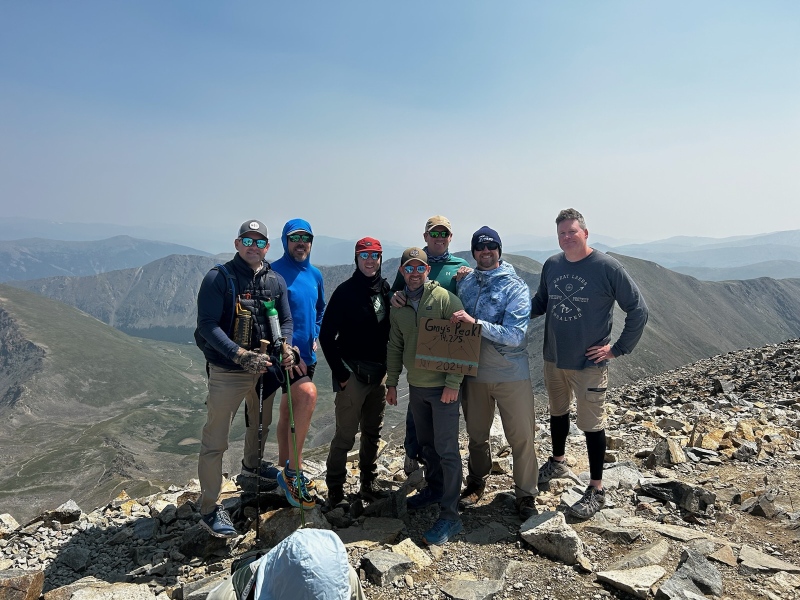
It is mostly a gravel trail consisting of dirt and rocks you must avoid stepping on as you go. It was tough for me to take in the surroundings due to having to watch each step. But I did take plenty of breaks in the first 2.5 miles. Around 2.5 miles you come to the first split, with Grays being to the left and Torreys going to the right. Our initial plan was to do both, but at this point in the hike I was completely dead and dragging the rest of the group down with me. I told my group to go on to Torrey’s, and I would slowly make my way to Grays alone and meet them there. BEST DECISION I MADE ALL DAY!! I then continued to Gray up the switch-back style approach. This last mile or so was extremely difficult for me as it’s at a high incline and the air quality is tough. Apparently, the wildfires in CA were contributing to lower-than-normal oxygen as well, but this was first time hiking at this elevation so hard for me to know. My pace up Gray’s approach was about 50-100 very small steps (think sobriety test) and then a couple minute break to catch my breath. I was struggling very hard, but honestly so were most people. Everyone was extremely nice on the way up, and the people coming down at this point were super encouraging about how close I was to summit. I summited Gray’s peak at 10:10am MT, so just under 4 hours for a single peak. The view over the peak is INCREDIBLE, and completely out of sight until summitting. My overall pace was very slow, but it was honestly as fast as I could go. The summit at Grays is expansive, with multiple areas to sit or gather. I would say size wise it was probably 30 feet wide and 100 feet long (roughly the size of a neighborhood cul-de-sac). The people at the summit were extremely nice, ranging from first timers like me to people with 4-8 14er’s. The temperature at the top was mid 40’s I believe, but it felt comfortable due to sunlight. Surprisingly to me and the rest of the group was the lack of wind at top of Grays. It may have been just our specific day but it seemed like most of the wind was being blocked by Torrey’s. Reports from the rest of my group who came from Torrey’s said it was much windier on that peak. 
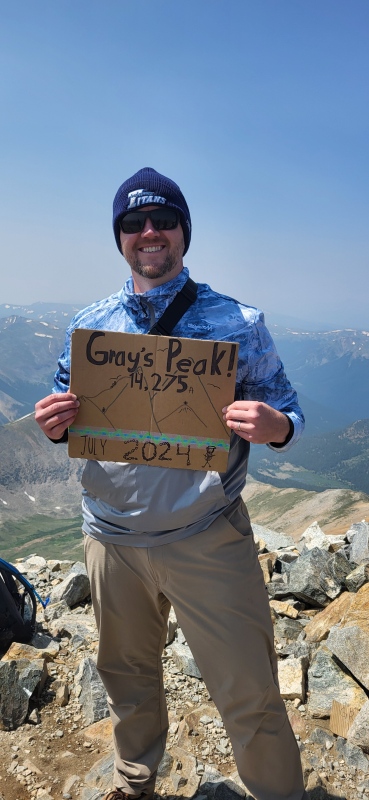
We could not locate the official elevation marker on either peak. From speaking with others it has been missing for a while, with speculation it was possibly stolen. There is also no “ledger book” or anything to sign as some websites suggested, although that seems like a cool idea. We enjoyed our ceremonious snacks and pictures at the top. I asked my daughter to make my “peak sign” and I was so proud of it when I got to top. People commenting about how great the sign looked and asking to use it (as opposed to leftover signs under rocks) made my heart full, and honestly the whole hike worth it. Highly recommend having something sentimental like that at top to put experience over the top. After snacks and pictures, we began our descent. The descent was overall much easier than the climb, although we had a few people in our group with joint problems. I am weak and out of shape, but joints are still ok so I did about average in the group on the decent. Although my boots were a bad choice, so my toes/feet were killing me (see below). The initial 1.5 miles decent off the summit was back down gravely switchback trail. After that it turns back into a fairly smooth decline trail. Again, not physically exhausting but constant steps down or decline, so feet and joints are a concern. We rounded the corner of the final ¾ mile, and I could spot the parking lot through the trees. I have never been so happy to see a rental car in my entire life!! Luckily the final mile or so is extremely easy and puts you back to parking lot in a positive mood. Total time car-to-car was 7.5 hours, with me undoubtedly slowing down the rest of the group. That time also accounts for roughly an hour spent at peak as I had extra time waiting for rest of the group to come from Torrey’s. Provisions: I started the day with 2.5 liters of water (accidentally left a filed 1L Nalgene at the house). I finished all of the water on our way back roughly a mile from the car. In hindsight, 3L would have been just about right in terms of balancing starting weight with necessity. Total calories consumed is estimated around 900 for the hike. One turkey and cheese wrap (only actual food) and snickers bar consumed at summit, and then two cliff bars and two fruit snacks were consumed while actually hiking. People were also giving out jerky and various other snacks at summit that I tried, so maybe another 75 calories consumed there. Some of our group had various “chews and goo’s” as they called them, which may have come in handy. I personally didn’t think this hike was long enough to prioritize speed or calorie denseness anymore than Cliff Bars or Fruit Snacks. Mistakes I Made: I believe I overdressed and possibly overheated slightly. I had on two layers, one full base layer (Under-Armor) and cargo pants and long sleeve windbreaker hoodie. Some people in our group only had shorts all day with no base layer and said they were comfortable. Looking back, I should have gone a bit lighter, but honestly so hard to tell just looking at temps. The sun keeps you warm more than you would think, but again you can’t always count on that. I wish I wore comfortable walking shoes!! This hike, at least in our weather conditions, did not require boots. I don’t have any “trail shoes”, so my options are trail boots or running shoes. Looking back, running shoes with a decently new outsole/tread on them would have been more than adequate, and way lighter. Key Takeaways: Elevation training is a must ahead of this type of endeavor. For anyone outside of the mountains, this probably means intense treadmill incline or Stairmaster. In addition, downward elevation training should take place as well. Weighted vest step-overs would have been helpful. Walking outside in normal terrain/elevation, even with a weighted vest and for the total distance you will travel, does NOT adequately train your body. Go at your own pace, even if you are with a group. I wish I had spoken up a bit earlier and not exerted myself so much in the first 1.5 miles. As mentioned, breaking from the group and going at my own pace was the best decision I made all day. I am deathly afraid of heights, but at no point during this hike or any others during the week did that come into play. You are never off the ground during the hike, and there are no spots where you must “clear a drop” or in any way be near danger with respect to heights. 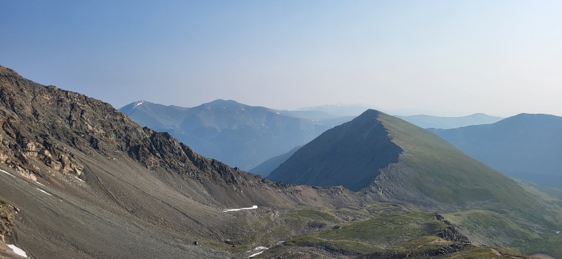
Thumbnails for uploaded photos (click to open slideshow): ")
")
")
")
")
")
|
| Comments or Questions |
|---|
|
|
Caution: The information contained in this report may not be accurate and should not be the only resource used in preparation for your climb. Failure to have the necessary experience, physical conditioning, supplies or equipment can result in injury or death. 14ers.com and the author(s) of this report provide no warranties, either express or implied, that the information provided is accurate or reliable. By using the information provided, you agree to indemnify and hold harmless 14ers.com and the report author(s) with respect to any claims and demands against them, including any attorney fees and expenses. Please read the 14ers.com Safety and Disclaimer pages for more information.
Please respect private property: 14ers.com supports the rights of private landowners to determine how and by whom their land will be used. In Colorado, it is your responsibility to determine if land is private and to obtain the appropriate permission before entering the property.

