| Report Type | Full |
| Peak(s) |
Golden Horn - 13,789 feet |
| Date Posted | 07/09/2024 |
| Date Climbed | 07/05/2024 |
| Author | kyrawhitworth |
| Additional Members | cloudkicker, Leereatiraza |
| The Horn of the Gold: All that Kitty Litter is Not Gold |
|---|
|
The Horn of the Gold: All that Kitty Litter is not Gold While perusing information for Golden Horn I found that a lot of great info exists but that this peak is very often looped with Pilot Knob or Vermilion. I wanted to provide a concise route summary from Ice Lakes for those interested in doing a less committed single peak route. I was a bit nervous about this peak as I felt that the info and photos I had may not be enough to give me confidence. I hope that what is here provides a helpful summary that is not overly redundant with existing info. I would still check out other existing trip reports like the one from pgres and Wild Wanderer for a complete idea but just this just skims everything down to one peak of focus. Preface (scroll on down for the info) While celebrating our anniversary in Vail, my husband was messing around on some rocks in the water fountain in the town and managed to break his leg. Spiral fracture fibula; really makes one wonder... Enter a dark depression/anxiety spiral of lost summer and fall plans. If you read my Gladstone report, the timing of me recovering from a knee injury couldn't be much worse. My husband told me that it is OK for me to keep hiking things while he recovers. The week of the 4th, I text Lee and cloudkicker and to my surprise they are both free, willing, and able to do my original Ice/Island Lakes itinerary. We have some preparation calls and soon enough we are on the road to Silverton looking to the west. We packed in on the 4th, dropped packs, summited V4, US Grant, and V2 and spent the the night at Island Lake. Grant was great and my only remark was the the descent to connect with the ridge to V2 saddle does indeed go but it may be less effort and time to go back the way you come up then head up to the saddle as that descent had a lot of route finding and some more difficult moves. On the 5th, cloudkicker got up early and trail ran down to the car and headed to Silverton for a work day. Lee and I would climb either Vermilion + Fuller or Golden Horn and decide based on conditions once we got into the basin. Cloudkicker even brought us dinner back from Silverton that evening which I thoroughly enjoyed after taking a nice post hike lake dip of which I have ample photos suited to fake influencer instagram world and not a trip report. Essentials for Kyra Helmet, microspikes, mini gaitors, poles. Trust me, descending without spikes would have made me cry super hard (which if you know me, I cry a lot so maybe not the best barometer there...) and at least one pole makes the looseness more tolerable. 
The Climb Lee and I slept in a bit and were off from camp around 8am. To get from Island Lake where we camped to Ice Lake you have to descend a few hundred feet and because it is so heavily trafficked there are slick spots in the dirt. The trail near Ice Lake was a bit muddy so we watched our steps and made our way past Ice Lake and followed the trail that leads to Fuller Lake. Before reaching Fuller Lake, we ascended a short grassy slope and found a trail through the mining rocks towards Diamond Mine. Before reaching Diamond Mine, we descended into the basin. The rocks are good here and you can pick up use trail fragments. We reached the basin and it was decision time. We began poking around in the snow and discovered that even though the sun had been baking it since sunrise, it was still rock hard at 9:30am. The trail from there to the Vermilion saddle was still completely filled in (though clearly melting out fast) and we did not feel good about it. We looked over the access gully for Golden Horn. We could see some snow spots but overall things looked dry. I sighed, a bit frustrated, as I knew it meant orphaning Vermillion + Fuller for another time but one wants to be sure. (I'm not a super fast hiker and we also promised cloudkicker we would not exhaust ourselves so that we could all three do Pilot Knob together when the new day will dawn.) I do know that folks had done Vermilion that same week from the Ice Lake side but they traversed Vermilion ledges from Golden Horn and one person was able to find a dry access gully for Vermilion but noted that it was really involved and nasty. I will also note that it looked like a good spring clean snow climb if you want to bring crampons for earlier in the season and I've seen a few trip reports for this. 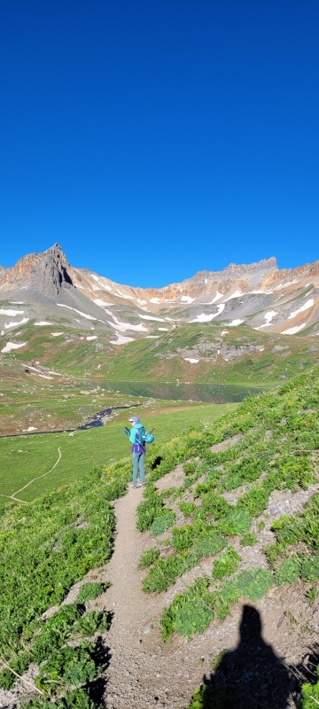
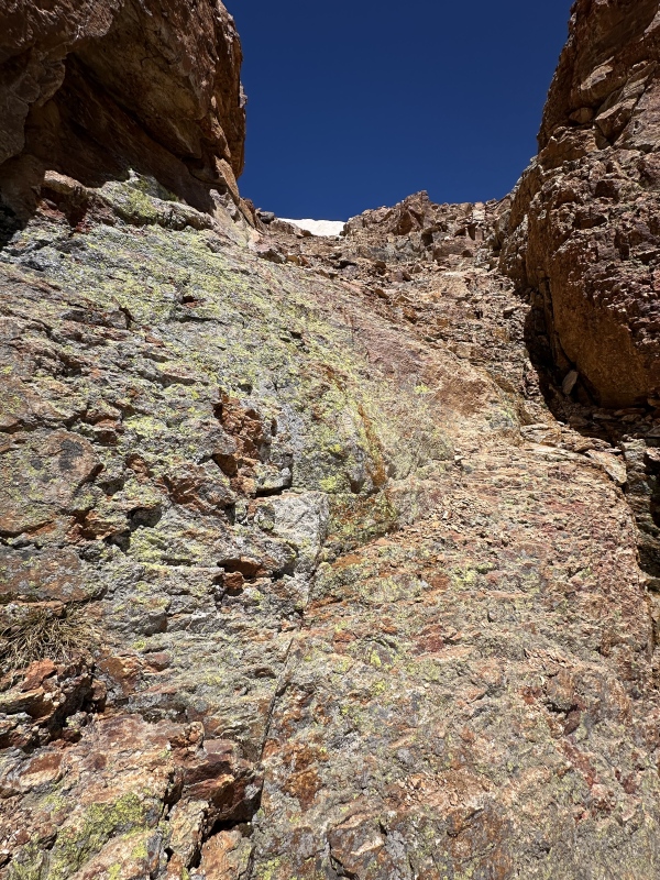
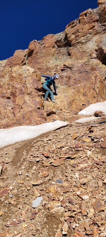
We headed towards Golden Horn and somehow I kept managing to find weird sandy mud sinking spots so my shoes were mud buckets (Lee joked that it was quicksand). The first section for Golden Horn is to access the cliff band and find an ascent spot through it. Getting up to the cliff band itself is just fine, a bit loose but I'll say "normal". From here pictures helped immensely as it seems like many places go but as you explore options, some go and some just won't go. What I will name as the "ascent spot" is the short gully described in pgres trip report. It is nice because it has distinguishable features creating a gap making it easier to spot when much of the terrain here all looks the same. I got up to the "ascent spot" and saw a lot of running water. We did bring spikes so I figured worst case, we just throw them on. As I'm in the spot I realized that some of the water is actually ice. Uh oh. I called out to Lee that he should explore a different ascent option. There had to be two paths we could go by. He poked around and found a couple ledges just to climbers left of this spot that went at Class 4. I evaluated the ascent spot and saw that the ice spots are all in the middle so I was able to find a couple footings on the far climbers left edge of this spot. The two weird moves went at Class 4. I met up with Lee above and we decided that both of our ways would not be good descent options and that we would need to take our time to find a work around on the way back. When dry, this "ascent spot" is definitely your best bet up and down. 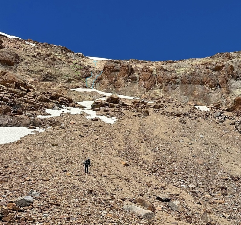
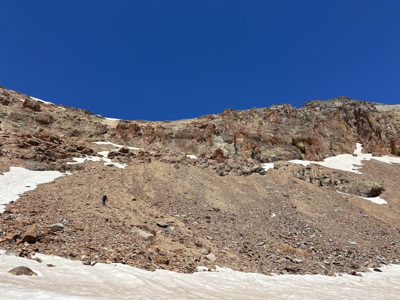
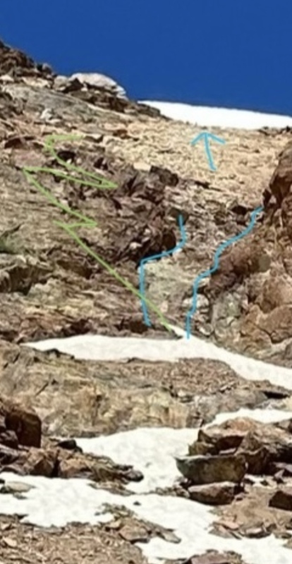
Up the gully to the saddle we go! To this point I had been blessed to have very little cursings for San Juan scree. That ended. The gully is a mix of the words most hardest impenetrable dirt (hardpan?) with embedded tiny rocks, loose dirt, loose kitty litter, loose bigger rocks, and just all around suffering. It was gross. The saving grace is that once you are above the cliff band, you are only a couple hundred feet from the saddle. We moved slowly and carefully. Lee and I were cautious to make sure we were never directly below or above one another. This was manageable with two people and I can see how larger groups or multiple parties could really compound things. The rocks here don't want to be and definitely want to roll. We took a break at the saddle before continuing along the ridge to the summit. 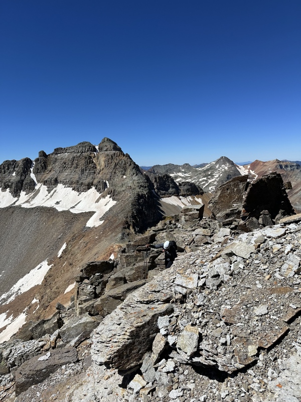
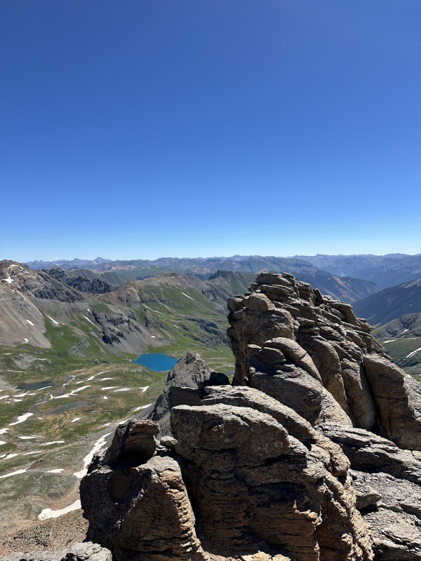
The terrain from the saddle to the summit is 2+ and honestly just fun. You can make it more scrambly by sticking close to the ridge or side skirt difficulties if you want and the stairways lie on the whispering wind. We ran into a guy on vacation descending who had somehow come up to the saddle from the Hope Lake side via a different basin than the route up to Vermilion from there (I have no idea as we did not get a view of him after that). We made quick work and ascended the blocky summit tower. It was 11am. The exposure on the pilot knob side is honestly astounding. Lee and I enjoyed a break with our heads humming and made a couple phone calls as we had good service. Looking down at the crowds of Ice Lake, we felt accomplished. We bumped over the other summit block and sure enough the first one is indeed taller. We could see a figure on Vermilion who had ascended from the Hope Lake side which just seems as though he is calling me to him. 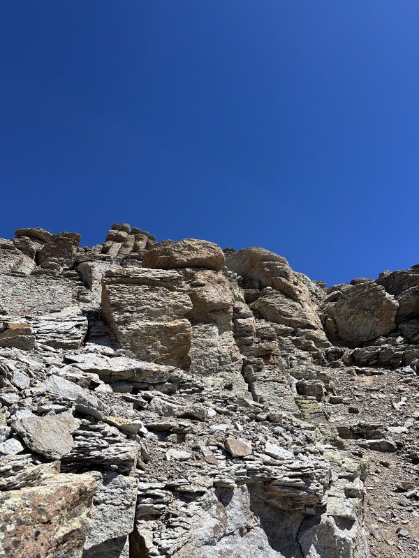
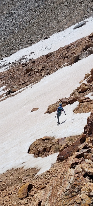
The descent to the saddle is straightforward and the same game of picking lines. Then it's time for suffering so we put on our spikes and game faces. We tried to trace our foot indents to find the least nasty way down. Spikes made this so much better than going up as a tumble from high on the nasty gully would not end well. We reached the top of the "ascent spot" much more quickly than anticipated (phew). I peered over and it still looked very wet. I didn't feel as though I could safety descend even with spikes despite it being short. Not to be alarmed now, Lee and I worked our way to the lookers right of this spot and found various ledges that went at Class 3. We had to scope several spots and change the road we were on before committing but thankfully found that some of the ledges with small loose rocks on them were just fine for butt scooting leading us to reason. We then were below the cliff band. I stubbornly decided to find a glissade since I'd brought the axe all this way. The snow was now supportive but nicely soft on top and I had a short glissade into the basin. "I'll be back for you, Vermilion." 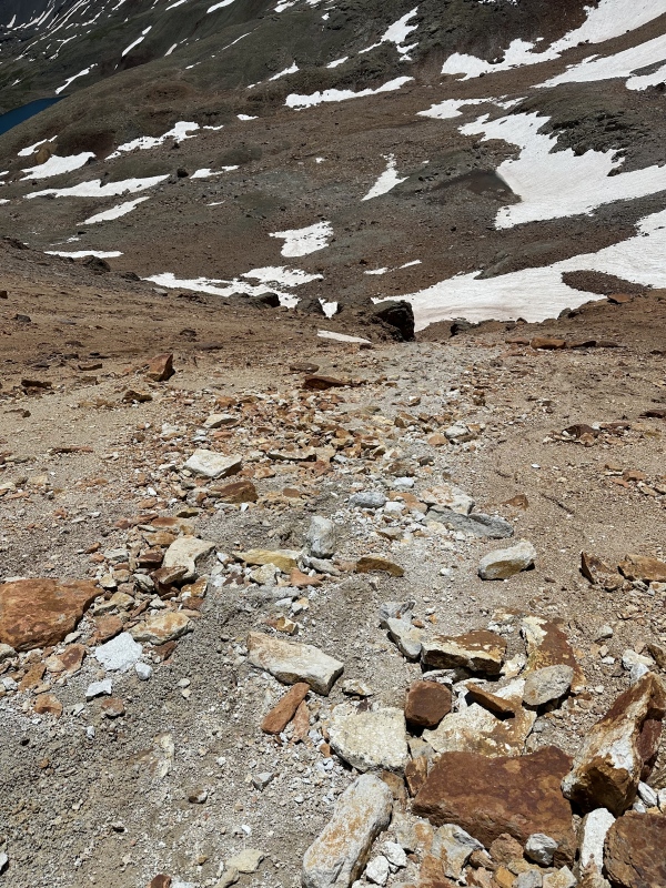
Once in the basin, it's easy to retrace steps up near the mine, towards Fuller Lake, and winding down the road/trail to Ice Lake. Due to crowds and echos of laughter, we did not stay long at Ice Lake but took some time to admire Golden Horn with a shadow taller than our soul that looks so impossible to climb yet has that nice backside ridge. I have included a gpx file as the RT distance and vert from camp was sort of unknown to me beforehand but I will say that it may be unhelpful as we found there's sometimes not enough definition to make sure you're in the right spot in terms of where to ascend through the cliff band. The pictures are likely going to be more helpful. I hope to bring my husband out here once he's healed up. Mellow is the man who knows what he's been missing after all. 
Thumbnails for uploaded photos (click to open slideshow): ")
")
")
")
")
")
")
")
")
")
")
")
")
|
| Comments or Questions | ||||||
|---|---|---|---|---|---|---|
|
Caution: The information contained in this report may not be accurate and should not be the only resource used in preparation for your climb. Failure to have the necessary experience, physical conditioning, supplies or equipment can result in injury or death. 14ers.com and the author(s) of this report provide no warranties, either express or implied, that the information provided is accurate or reliable. By using the information provided, you agree to indemnify and hold harmless 14ers.com and the report author(s) with respect to any claims and demands against them, including any attorney fees and expenses. Please read the 14ers.com Safety and Disclaimer pages for more information.
Please respect private property: 14ers.com supports the rights of private landowners to determine how and by whom their land will be used. In Colorado, it is your responsibility to determine if land is private and to obtain the appropriate permission before entering the property.


