Download Agreement, Release, and Acknowledgement of Risk:
You (the person requesting this file download) fully understand mountain climbing ("Activity") involves risks and dangers of serious bodily injury, including permanent disability, paralysis, and death ("Risks") and you fully accept and assume all such risks and all responsibility for losses, costs, and damages you incur as a result of your participation in this Activity.
You acknowledge that information in the file you have chosen to download may not be accurate and may contain errors. You agree to assume all risks when using this information and agree to release and discharge 14ers.com, 14ers Inc. and the author(s) of such information (collectively, the "Released Parties").
You hereby discharge the Released Parties from all damages, actions, claims and liabilities of any nature, specifically including, but not limited to, damages, actions, claims and liabilities arising from or related to the negligence of the Released Parties. You further agree to indemnify, hold harmless and defend 14ers.com, 14ers Inc. and each of the other Released Parties from and against any loss, damage, liability and expense, including costs and attorney fees, incurred by 14ers.com, 14ers Inc. or any of the other Released Parties as a result of you using information provided on the 14ers.com or 14ers Inc. websites.
You have read this agreement, fully understand its terms and intend it to be a complete and unconditional release of all liability to the greatest extent allowed by law and agree that if any portion of this agreement is held to be invalid the balance, notwithstanding, shall continue in full force and effect.
By clicking "OK" you agree to these terms. If you DO NOT agree, click "Cancel"...
June 5th, 2024 - Gray's and Torrey's Peak via Loveland Pass
Beautiful hike, beautiful conditions - at least for the first bit. This is a challenging route, as I'm sure most are aware. You begin by summiting two moderate 13ers (Cupid & Grizzly D), only then beginning to ascend Torrey's, which further connects to Gray's. Very clearly not the standard route to accomplish the two 14ers, but a fun one, nonetheless.
Torrey's Peak as seen from the summit of Cupid Peak.
The first thing I noticed today was that there are heavy snow drifts that hang on the east side of the ridge between Cupid and Grizzly D. I would only assume this is where the trail leads, but due to the snow and my unwillingness to drift toward overhanging snow drifts, I decided to hang right on the ridge. Hanging right is fun, but it will put you into some more technical scrambling with potential 4-points of contact. Be aware and take time to route-find well.
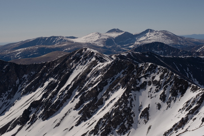
There is a fairly significant false summit as you approach Grizzly D, and the final pitch of Grizzly D itself is quite steep. Be prepared for the incline. Once atop Grizzly D, enjoy the views of Torrey's, Gray's, Sniktau, Lenawee, A-Basin, and so much more. Truly a beautiful area.
Cupid Peak as seen from the final pitch of Grizzly D.
The descent from Grizzly D to the west face of Torrey's is steep and should be handled carefully in the snow. Hang as far left as possible when descending the ridge. I made the mistake of drifting too far right into the basin itself and found myself on very slick and steep ice slopes. I had to utilize an ice axe to prevent myself form slipping down the entire slope. The descent from Grizzly D into the basin will drop you about 750-1000ft of elevation. Don't disregard this, you will have to come back up later should you choose to do the out and back route.
Grizzly D as seen from the saddle between it and the west face of Torrey's.
Approaching Torrey's from the west is a grueling hike, with approximately 2000ft of vertical gain over a short period of distance. With snow, a handy couloir allows for steady traction assuming the use of micro spikes and/or crampons. Besides that, you will find the rock will get considerably looser as you go up, which will be a challenge for coming down.
Once you reach the summit of Torrey's, the saddle to Gray's becomes quite obvious. Follow cairns if you need directions, but they're both fairly tame mountains.
Eastern ridgeline of Gray's Peak as seen from the summit of Torrey's Peak.
I ended up doing the route as a thru route and finishing at the trailhead of the standard route for Gray's and Torrey's, and I did this for one reason in particular. The elevation gain on this route from Loveland Pass is extreme, and quite steep. Unless you are in spectacular shape, it is an exhausting and painful route - yet rewarding, nonetheless.
The descent from Gray's back to the standard trailhead had a ton of wet snow that resulted in anyone being especially prone to post holing - plan accordingly.
Beautiful route, hard day, spectacular mountains.
Thumbnails for uploaded photos (click to open slideshow):
Caution: The information contained in this report may not be accurate and should not be the only resource used in preparation for your climb. Failure to have the necessary experience, physical conditioning, supplies or equipment can result in injury or death. 14ers.com and the author(s) of this report provide no warranties, either express or implied, that the information provided is accurate or reliable. By using the information provided, you agree to indemnify and hold harmless 14ers.com and the report author(s) with respect to any claims and demands against them, including any attorney fees and expenses. Please read the 14ers.com Safety and Disclaimer pages for more information.
Please respect private property: 14ers.com supports the rights of private landowners to determine how and by whom their land will be used. In Colorado, it is your responsibility to determine if land is private and to obtain the appropriate permission before entering the property.


")
")
")
")
")


