| Report Type | Full |
| Peak(s) |
Longs Peak - 14,259 feet |
| Date Posted | 05/10/2024 |
| Date Climbed | 05/04/2024 |
| Author | cpthefriend |
| Keplingers Couloir - Longs Peak |
|---|
|
Longs Peak Route: Keplingers Couloir Trailhead: Sandbeach Lake Distance: 16 miles Vertical Gain: ~5,900 feet Time Elapsed: 12 hours 30 minutes Knowing we were in for a Longs day, we got an early start: walking ~3am from the Sandbeach TH. We walked roughly 2 mi with skis on our back before putting on skis (at Campers Creek turn off). It turned out this was a little premature, and in retrospect, we probably should've walked around 3 mi. There was a little bit of on again off again snow between miles 2 and 3. Nonetheless we continued on and crossed a wooden bridge, then a snow bridge, continuing on towards Sandbeach lake. At the time we noticed some clouds around, although it seemed clear above us (nice stars!) 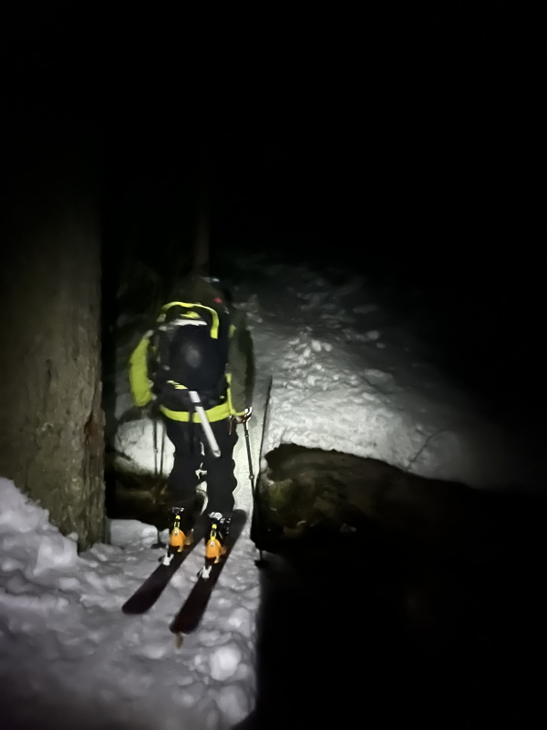
We continued to skin up the trail to the edge of Sandbeach lake. By this time dawn had broken and we began to see Longs. Contouring around wild basin, we kept high on the southwest side of the valley, above Hunters Creek. We eventually crossed the creek to approach the base of the couloir. This section was roughly 6-7am and as we hit tree line we started to feel the wind dropping the temperatures... hands were chilly! But we were rewarded with a view of our line for the day. Travel up to this point had been quite smooth and efficient 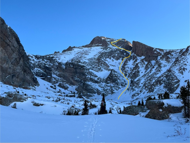
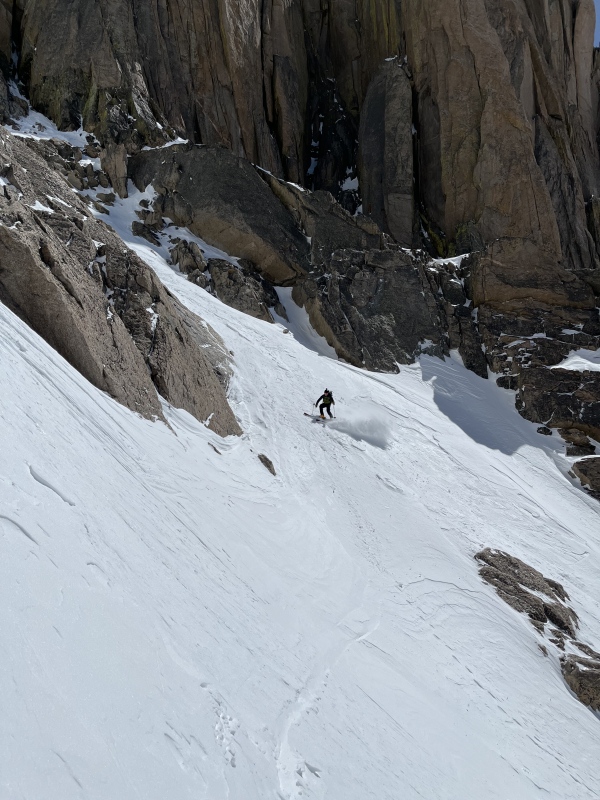
Around this point, another powerhouse group had caught up to us from the parking lot. This was convenient as they would essentially lay the bootpack highway up the couloir. We had certainly traveled some miles by this point, but it was from here on up that the real work started. We skinned up to the basin and then began the heavy lifting. My partner used ski crampons to continue up the apron towards the low choke point (roughly where the couloir's path takes a left hand turn - left on the way up that is). I on the other hand switched to crampons near the start of the couloir and began to boot. A rough estimate is around 2-2.5 hrs of booting, before we reached the top of the couloir. This was of course hard work but - hey thats what we were there for - included some great views. Looking back across the basin we had realized that the clouds we saw earlier were an inversion socking in the lower elevations. 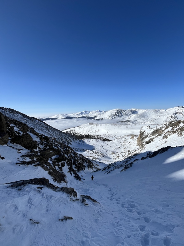
Snow conditions going up the couloir were pretty good with some variation in hardness of the snow (from toe deep to ankle deep footsteps), but nothing like the wallow-fest described by dedicateddave the previous week. Also of note, when we reached the top of the couloir - around 9:30 - we were only just exposed to the sun. The couloir stays in the shade relatively late into the morning (since the Palisades are tall and well situated). In our experience this meant it softened slower than we had anticipated. At the top of the couloir it was a bit windy, and after an assessment of time, weather, and snow conditions, we decided to continue on to the summit. This meant an exposed traverse of a steep snowy slope. I was grateful for my ice axe and crampons here. The snow was a bit deeper in parts (~knee deep), so we traversed at a slower pace. 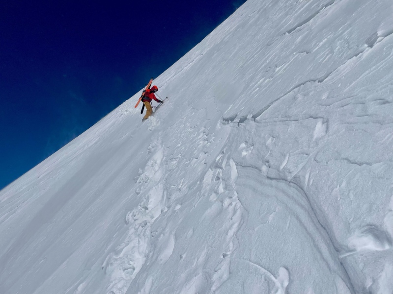
After this traverse we were on the Homestretch. This section was not completely snow covered, making for a couple of non-trivial mixed tooling maneuvers to cross rocks and connect snow patches. It was certainly windy, and I was feeling the altitude + 7 hours of adventure thus far, but we pushed on towards the summit. On the homestretch we ended of sticking further right than we originally anticipated. This was to follow a continuous snow patch, and in the end we saw some of the summer blazes on the rock, assuring us we were on the right section. 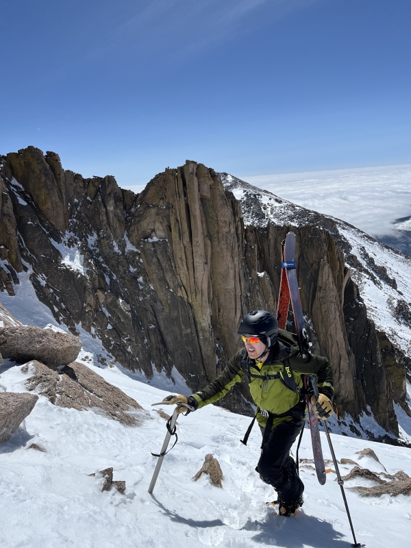
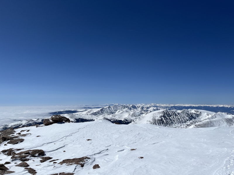
At roughly 10:20 we popped over the lip and onto the gracious and welcoming summit of Longs Peak. We were rewarded with truly stellar views. Clear skies to the west, with an expansive view of the Colorado rockies. We could pick out peaks like Pikes, Torreys, and others. To the east was a carpet of clouds: the largest inversion I have ever seen, stretching from the front range as far we could see. I would like to assume it went all the way to Kansas... 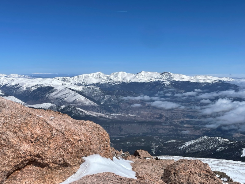
At the peak we ran into another party who had come up from the other side. They said the skied to the Boulder field and then hiked up with crampons from there to the peak. After a short break to catch out breath and appreciate the view, we began our descent. We retraced our steps down the homestretch and across the traverse to the top of the couloir. On the traverse we ran into another party who had come up Keplinger's. In the end they started after us and finished before us... another power team! We found a flat-ish spot just below the traverse and above the couloir in which to put on our skis and begin the fun stuff. Taking turns (leap frog style) we made our way down the couloir. It started out with a few hundred feet of safety skiing up to the top choke point. From there things softened up for some nice chalky spring skiing. The turns were good, but came with a healthy side of leg burn. There were a number of opportunities to stop in safe spots off to the side and wait for each other to catch up. 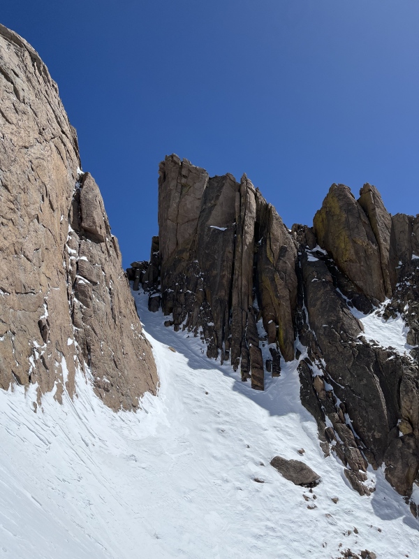
We skied down to the basin - loved it - and then looked back to appreciate what we had just skied. 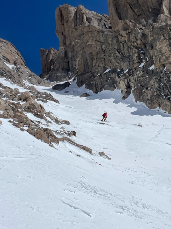
We then started to follow the up tracks back towards the trailhead. When we got to the Hunters Creek basin we reckoned that perhaps we could follow that back to the trail below Sandbeach Lake (instead of skinning back across the basin (with some up) and regaining the trail near the lake). This path took us along the creek, to the north east of our uptrack. This is way the bush whacking and mental disintegration hit us. This was the famed bush whack of wild basin... We estimated this detour added near 1-1.5 hrs to our descent. In retrospect, the uptrack near sandbeach had been remarkable smooth skinning with minimal bush whacking. We certainly should just stuck to this route on the way down. Consider yourself warned! Instead we wallowed about in the hot afternoon sun and flirted with the creek and the slush. We stopped to filter some water and snack to keep ourselves going. When we finally regained the trail, the descent quickened. Well that is until the snow ended. By this time in the afternoon, there was considerably less snow, and I was wishing we had stashed our shoes slightly higher up the trail. To trade ski boot hiking for shoe hiking would have been a generally positive trade. Made it down to the base to round out the trip in about 12.5 hrs all told. Overall the day went quite smoothly. We (and the other groups) had good weather that rewarded our hard work with some phenomenal views, a very aesthetic line, some great turns, and a little bit of slog. It was a highly rewarding day! For those looking to ski this route, my advice is to stay to the south west side of the basin near Sandbeach lake, and to hike farther than you think you need to before putting on your skis. Thumbnails for uploaded photos (click to open slideshow): ")
")
")
")
")
")
")
")
")
")
")
")
|
| Comments or Questions | ||||||||||||
|---|---|---|---|---|---|---|---|---|---|---|---|---|
|
Caution: The information contained in this report may not be accurate and should not be the only resource used in preparation for your climb. Failure to have the necessary experience, physical conditioning, supplies or equipment can result in injury or death. 14ers.com and the author(s) of this report provide no warranties, either express or implied, that the information provided is accurate or reliable. By using the information provided, you agree to indemnify and hold harmless 14ers.com and the report author(s) with respect to any claims and demands against them, including any attorney fees and expenses. Please read the 14ers.com Safety and Disclaimer pages for more information.
Please respect private property: 14ers.com supports the rights of private landowners to determine how and by whom their land will be used. In Colorado, it is your responsibility to determine if land is private and to obtain the appropriate permission before entering the property.


