| Report Type | Full |
| Peak(s) |
"Black Mountain" - 13,197 feet Grizzly Peak - 13,435 feet "Cupid" - 13,126 feet |
| Date Posted | 03/12/2024 |
| Modified | 03/25/2024 |
| Date Climbed | 03/09/2024 |
| Author | daway8 |
| Black Ops 1st Winter Ascent |
|---|
|
This was an absolutely awesome climb and, as far as the limited records I see indicate, it might possibly have been the first known winter ascent of this peak. But even if someone else has already done it in winter, I still went at it with virtually no beta and entirely invented the route myself on the fly so I think it still holds to the spirit of a first ascent even if someone else comes forward to say they've done it [Update: see comments - yep, not too surprised, turns out it has been done before]. In either case, this was a wildly fun adventure that I can't wait to share! There will be lots of storytelling in this report - jump to the large bolded BETA section if you're mainly interested in key features of the climb. If you're someone who likes tackling challenging peaks without beta then you might want to stop here and go do this one while it's still snow covered - but be careful, this is a very short but spicy route - please at least look at the warnings/alerts below! I won't be going into nearly as much route detail as I sometimes do (I don't want to spoil all the fun for folks) but I will share just enough beta to give interested people a head start, so don't look too close if you don't want too many spoilers! Included in this report will be:
Trailhead: Loveland Pass Route: Cupid to Grizzly to Black Mountain then reverse Total Gain: ~3,100ft Total Distance: 6.5 miles (yes, that's right - and that's the ROUND TRIP distance!) Total Time: Um, let's not talk about that just yet, lol. Difficulty: Class 2 to Grizzly and the Grizzly-Black saddle then Class 4, plus or minus for the final quarter mile or so, depending on the exact route and what snow conditions force you into (in chatting around, some say in summer it's no worse than maybe a stiff class 3 but it's safe to say in winter you can easily hit class 5 depending on what approach you take). WARNING: This route has some major avalanche potential - in fact, I realized after the fact that the route I ended up taking the second time was only viable because an avalanche seems to have ripped much of the snow off of exactly where I went up to gain the ridge. Had I tried to do that path on the first trip I would have been carried over half a dozen or so exposed rock bands by that avalanche - I shuddered when I put all those pieces together by analyzing the photos at home. In retrospect, I still feel like I made careful analysis of every bit of progress I made and my choices were risky but not insane given the observations I made on the ground. But in hindsight I seem to have threaded the needle more finely than I realized. As a result I will NOT be posting a GPX track because this route would NOT be safe under circumstances that were closer to my first trip than my second. So be warned: this route is not for the faint of heart in winter! It's a total blast if you're up for a short but intense burst of scrambling in the last quarter mile or so! Proximity Alert: Note also, that you're looking down on A-Basin ski resort from this peak. As best as I can tell, the main ski slopes are positioned such that, if you did manage to trigger an avalanche off the west side (not overly likely given how rugged and wind blasted that side is) you shouldn't have to worry about it running into the resort. However, there are sometimes backcountry skiers who make tracks under this peak so please be alert and careful not to put others at risk. The east side holds far greater danger of triggering an avalanche (including by triggering huge cornices) but that side goes into a typically deserted valley. 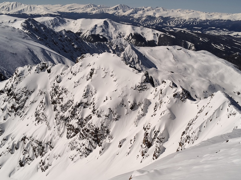
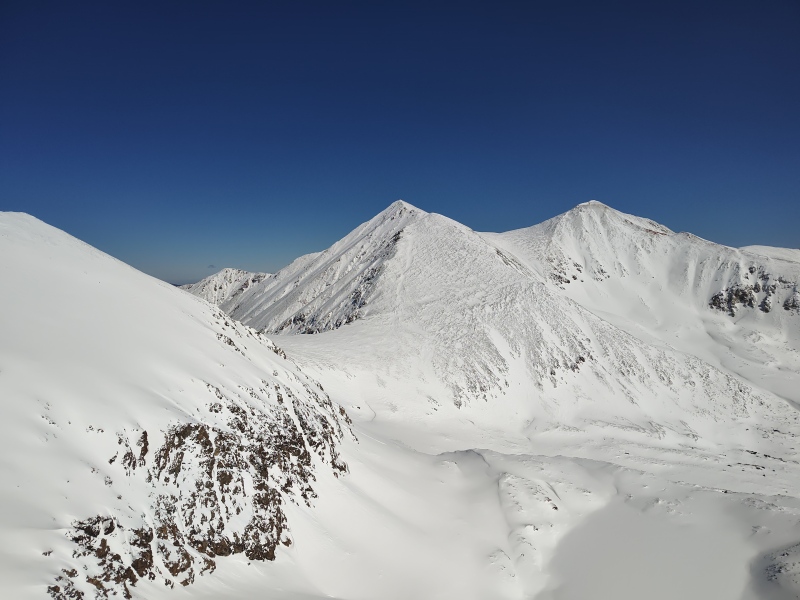
The New Kid on the Block - Lidar Updates Welcomes Black Mountain I had previously finished all the 13ers in this area of the Front Range so I was surprised one day to be scrolling across the map doing some research and spot a 13er without a check mark on it. It was only after Bill made all the Lidar updates that this unranked 13er showed up on the list - but don't give up on it just yet simply because it's unranked - this is a small but sweet peak! If you're looking for a good workout and good scrambling practice without going too far, this is a perfect route. The trailhead is Loveland Pass, which is plowed in winter (even if you sometimes have to wait a bit after a storm, as was the case on my first attempt) and the total round trip distance is an unbelievably short 6.5 miles! But within that short little distance you get a heck of a lot of ups and downs - check out the elevation profile below! 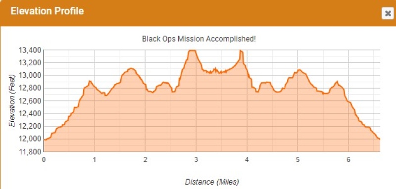
Why do this mountain in winter? So why would I go after this little unranked 13er and in winter? Several reasons actually. One was just the pure, rare novelty of spotting a Front Range 13er for which there were no reported winter ascents, no conditions report, no GPX tracks, in fact almost no beta out there at all. There are very few "firsts" of any kind left in the world of mountain climbing, unless your name is Alex Honnold. I'm no Alex, so I have to really scrounge around to find my own little micro-achievements and this looked like a fun one (even if, like I said, it's entirely possible someone else might have actually done this in winter before and just not recorded it since it hadn't even been on the checklist until recently - it still has all the exciting feel of a first ascent when you go into it basically blind in terms of beta). 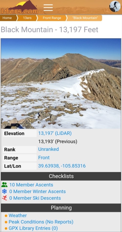
The other main motivation is that, with my winter 14er count now sitting at 24, I'm been pondering for a while now if I want to try to maybe actually go all the way and see if I can join the ranks of the Frozen Finishers. But in order to do that, unless I semi-cheat and only take on peaks in the driest of all winters, I'll more than likely have to do at least some degree of winter scrambling. Longs peak was a great place to level up my skills when I did first an intense spring climb in Snowy Longs up Keyhole down Cables and then did a proper winter snowflake in Longs Winter Keyhole. But, honestly, this short climb up Black Mountain felt far more intense than doing Longs in winter due to a combination of the especially rugged terrain and the fact that I had virtually no clue at all as to what sort of route to take. I only knew some folks had done it in summer. I had looked over at the ridge it's on in summertime and remember thinking even then that it looked rather gnarly. It winter it's eye-popping! Black Ops Recon - the First Attempt (Feb 17, 2024) It was Friday Feb 16, 2024. The forecast for the weekend was a little sketchy but not horrible - the worst part was the weather Friday evening. After much discussion I had finally settled on plans to go do Horseshoe and some of the surrounding 13ers near Sherman with Geo and Mary. But the drive out to Silverthorne proved somewhat sketchy and roads started closing all over the place. In the end, Mary decided not to risk the roads and Geo decided that the ski slopes around Aspen were calling. So that left me alone in Silverthorne wondering what to do with my Saturday. With so many of the surrounding roads/passes closed I took advantage of a rare opportunity to sleep in. Then I flirted with the idea of maybe going up Loveland Pass for at least a quick recon trip to scout out conditions on Black Mountain and maybe get a little conditioning in while I was at it. But by mid-morning the Pass was still closed. I used the COtrip Planner app to periodically check webcams and road closures and finally a vehicle showed up in the LP webcam, although it still claimed the road was closed. 10 minutes later there were several more vehicles present in the webcam and now the road shown as open. So I headed on out with the thought of at least getting eyes on the prize. 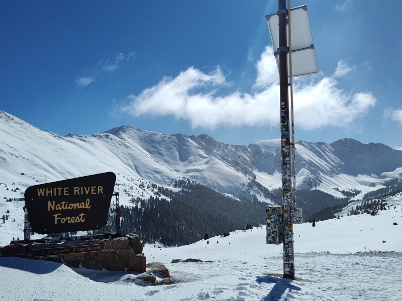
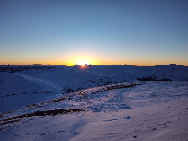
The weather was beautiful and Black Mountain looked pretty dry on the west side, as best as I could tell from the Pass. 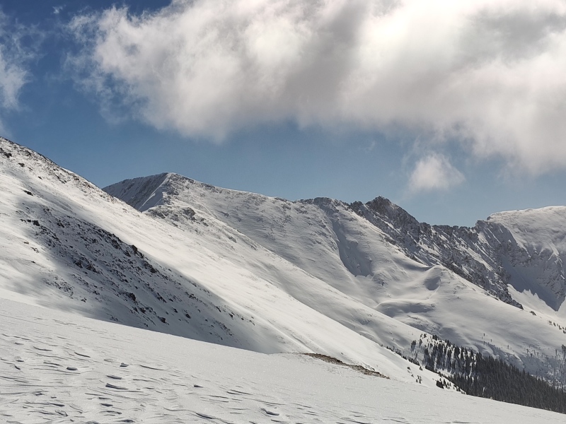
As I went further along the ridge I started feeling a growing optimism that began to morph into excitement as I saw how windblown everything was, how perfect the weather was and how easily I was cruising towards my target! 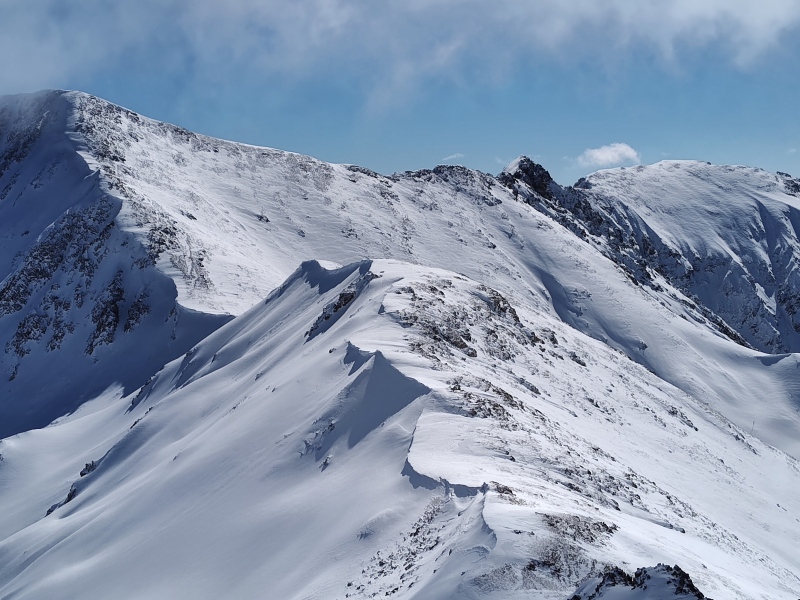
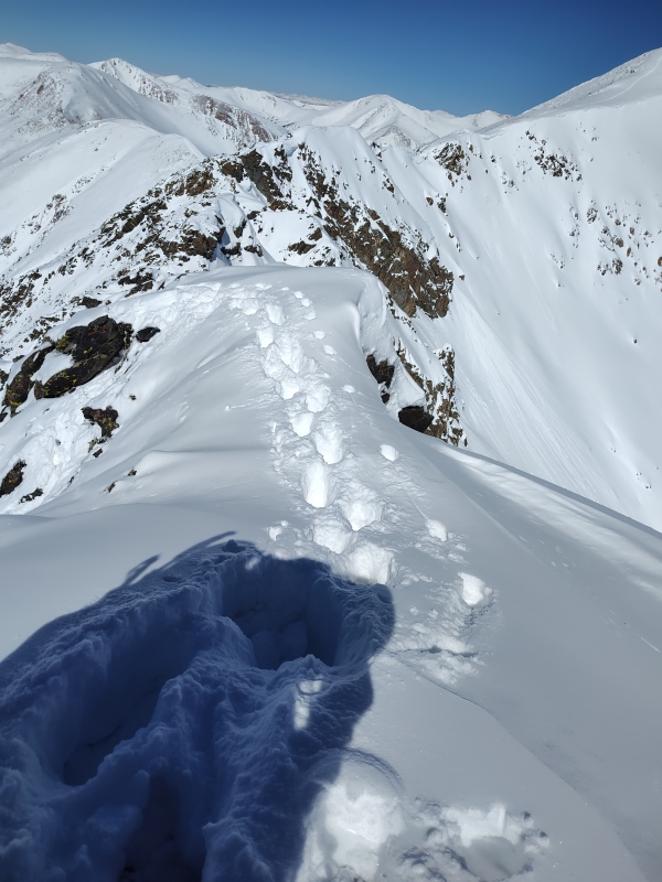
Finally I hit Grizzly Peak after a few hours on the roller-coaster ridge. It was already almost 3pm thanks to the crazy late start but I was feeling great and conditions seemed as perfect as they were ever going to get. So I shot Geo the following text so at least someone would know where to look for my body if anything went wrong: "Houston we are go for launch!!!!!! ENGAGING OPERATION BLACK OPS!!!!!!!" [I had been all secretive about this climb, only even alluding to it to a person or two and not giving any details until just before doing it - the code name was part of the goofy fun of this "secret mission"] 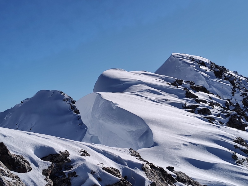
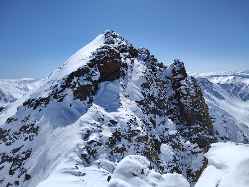
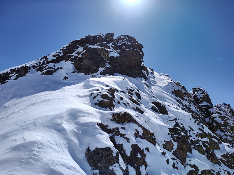
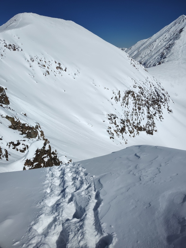
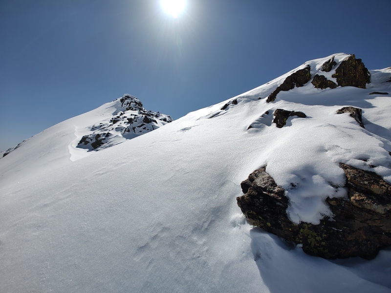
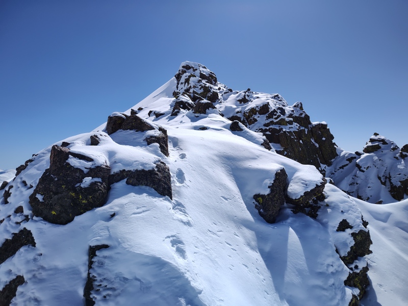
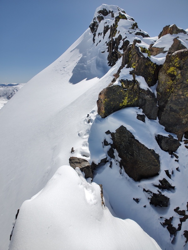
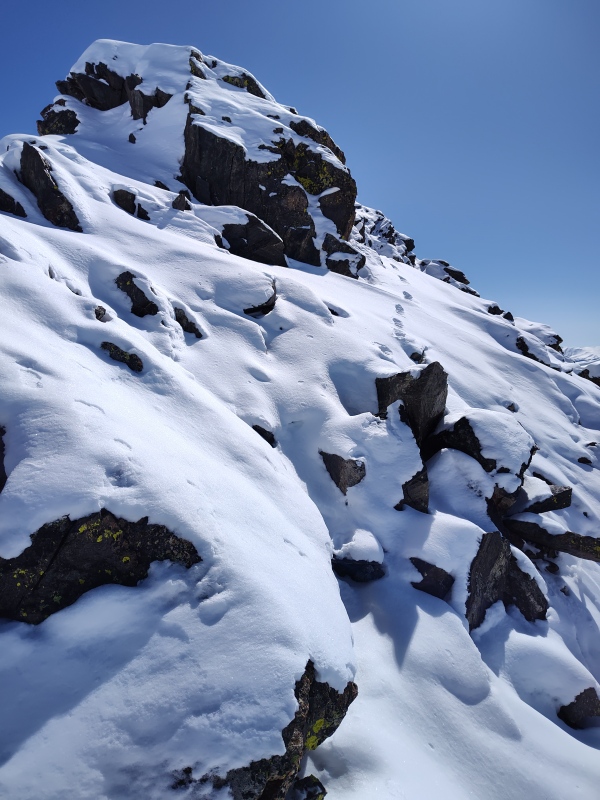
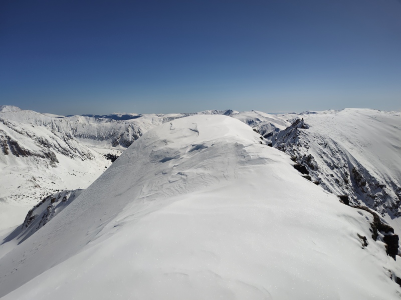
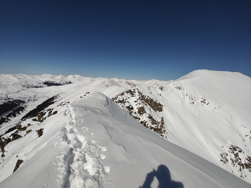
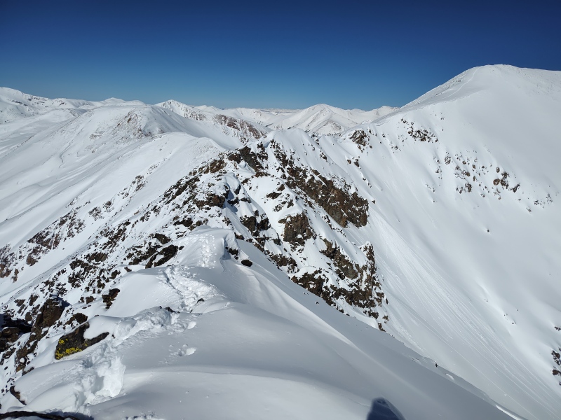
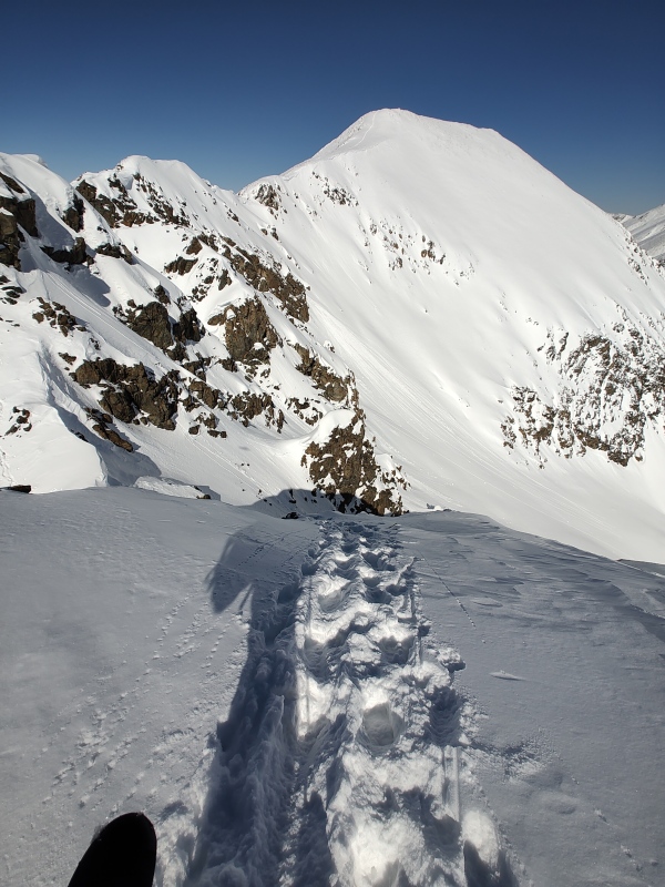
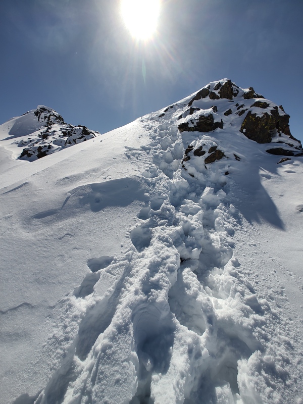
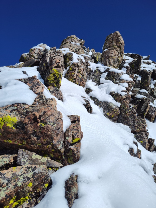
It's only 0.41mi from Grizzly to Black and the first part until almost the saddle is mostly a mellow stroll as long as you don't step too far to the left (east) and fall through a cornice. Then it quickly starts to get spicy. You have to decide when to try to go over or around or possibly drop down. I got past the couple humps on the ridge and made it to the final saddle at about 12,950ft. The summit is 13,197ft so it's just under 250ft to gain the summit, but it's a wicked 250ft of gain with no easy options apparent in winter. 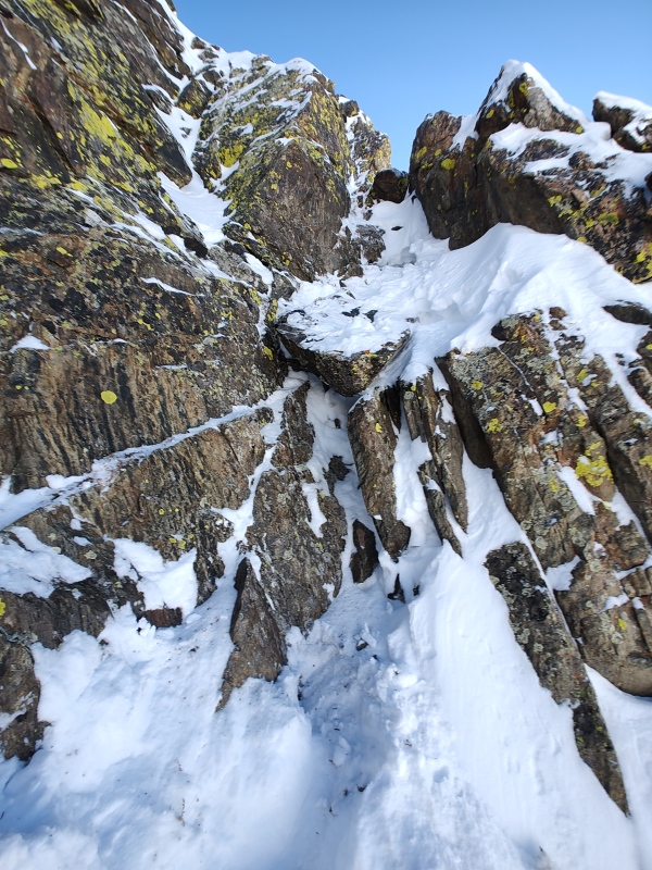
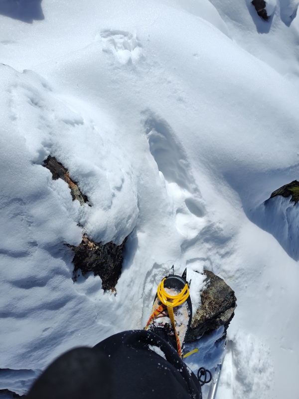
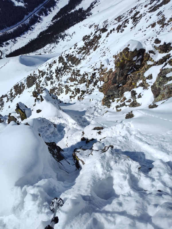
Armageddon Twister On this first day I just had on regular hiking boots and microspikes. That was not really adequate for the terrain I was trying to tackle, but then again I had set out that weekend with the intent to climb Horseshoe Mountain and that's not really a mountain you bother to pack mountaineering boots and crampons for. I don't believe this section would have been all that hard for me in summer - in fact it looks fun enough that I may very well come back just for some fun scrambling - but with all the snow coating it was getting rather treacherous. Finally, with the sun getting ever lower in the sky, I found a small snow gully where the snow felt really firm. Sweet!!! This is my ticket to the summit! With a little more enthusiasm than prudence I started up the snow gulley, thinking back to all the spring climbs where I had done similar things. But there was one small problem. This wasn't spring. There's a reason why people generally wait until spring to do snow climbs. I was reminded of that reason as the sheet of snow I had put the full weight of my body on cracked and slid off the face of the rock slab beneath it. I probably looked a bit like a cartoon character scrambling wildly with limbs flailing every which way to get off the sliding snow and try to find purchase on what it was quickly becoming apparent was a class 5 rock slab that was almost entirely devoid of holds. My right hand stretched as far over to the right as it could to grab a small little knub. My left foot lurched up and way to the left to catch the points of my microspikes on a tiny crack. My right foot slipped and slid and searched until finding a microscopic bump that somehow held it and my left hand searched wildly until finding a fingertip hold at an awkward angle above me. My winter would-be snow climb had just turned into a game of Armageddon Twister! Now you would think that one might panic in such a situation, but such was my obsession with my "mission" that after the brief, intense few seconds it took for all my limbs to gain some manner of purchase, the first thing I did was look up and say to myself: 'hey, I think I might see some viable holds that got uncovered when the snow slid off!' Then I looked down at where the snow had slid off to. I mean it wouldn't necessarily have been fatal - depending on how much speed I gained in the initial slide... But the sun was getting very close to the horizon and playing Armageddon Twister in the dark at 13,000ft is a little bit much even for my sense of adventure so finally the rational side of my brain kicked in and told me it was time to bail and get off this ridge before it got dark. 
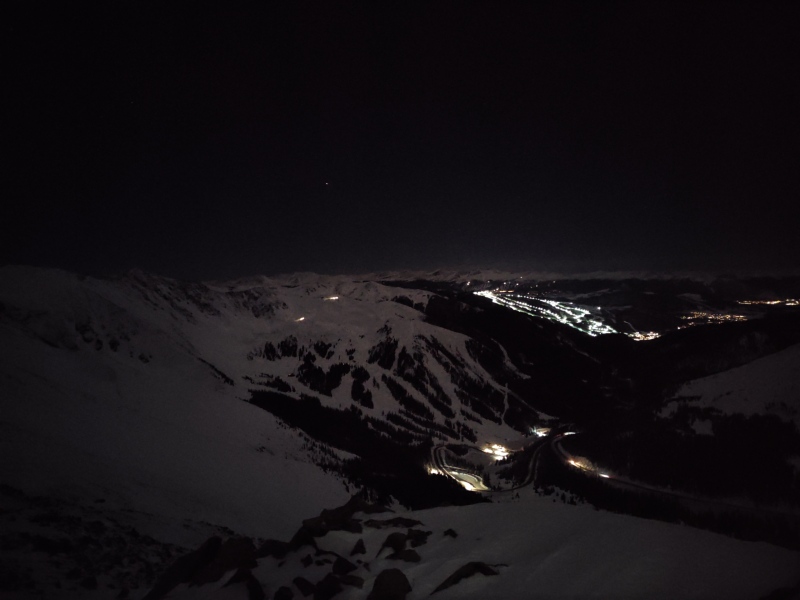
By the time I made it back to the first saddle where I had stashed my snowshoes the sun had dropped below the horizon and I could see lights in the surrounding communities. 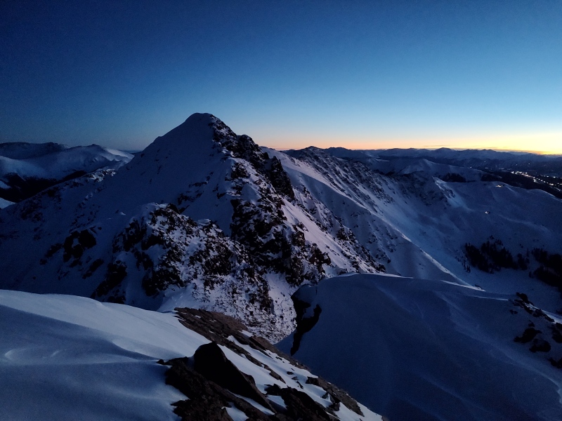
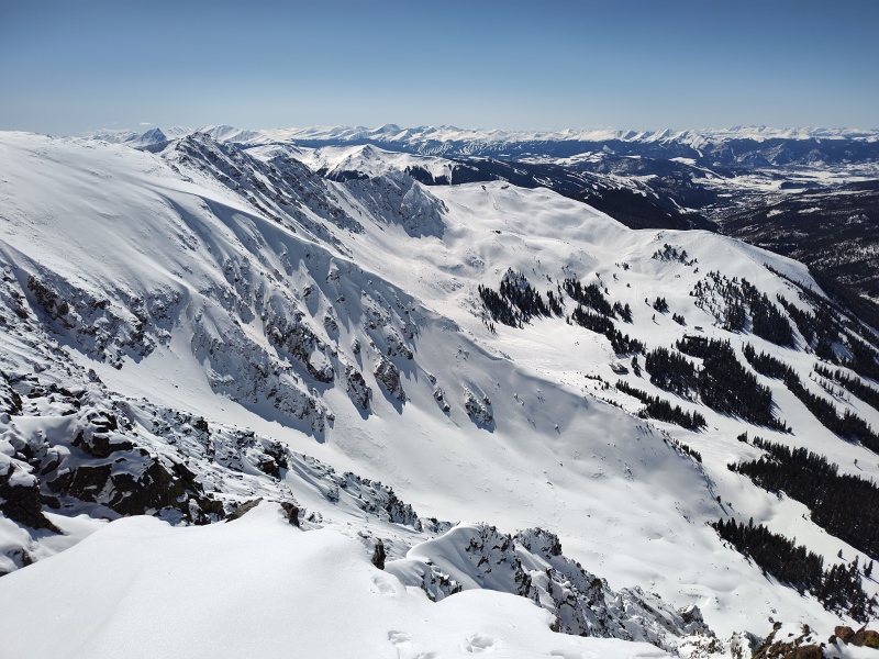
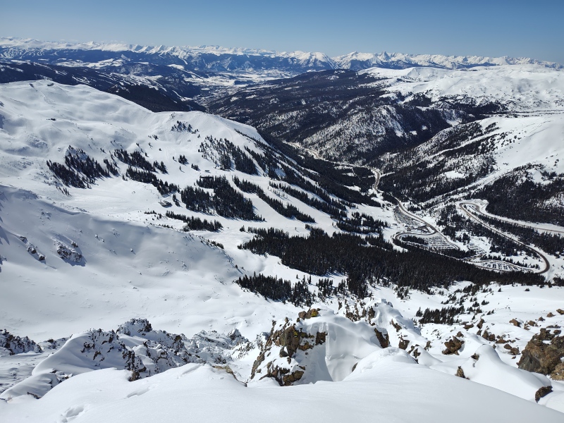
There are actually really cool views up on this ridge after dark, between Loveland Pass, A-Basin ski resort, etc. 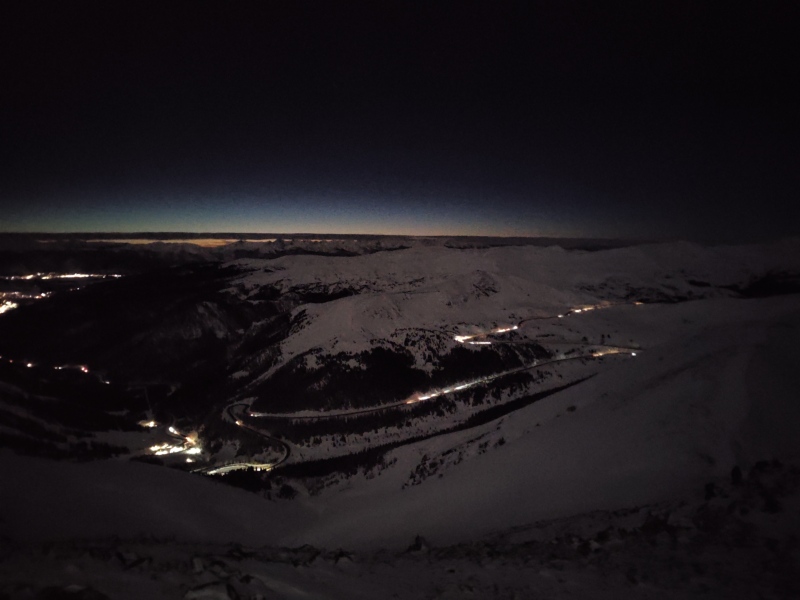
So I filed this climb away silently as Black Ops Recon and didn't post anything online for fear of giving away my "secret mission." Black Ops - Mission Accomplished! As the winter went on I continued to eye conditions around Loveland Pass very closely. But I also made it a point to stick with my goal of not being a total loner and made sure to get out some with other people. But even as I did so I kept my secret mission hush, hush amongst all but just a couple of people. Once again I had plans for the weekend to go do a climb with other people - this time Redcloud and Sunshine, with the hopes of getting another pair of 14ers to balance out the pair I got earlier in the winter with Tab Winter Revenge. But again, the weather on Friday (aka travel to the mountains day) took a turn for the worse as the weekend neared and I opted not to try to drive across the entire state during a snowstorm. After eyeing the weather reports though I decided I could probably get out to Silverthorne and so this might just be the right time to go make a second attempt at my Black Ops mission! 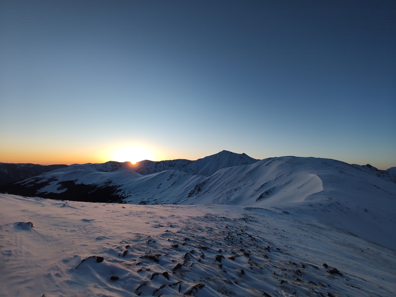
This time the road up Loveland Pass did not get closed by the storm and I made a more proper start at about a quarter past 5 in the morning on Saturday. I goofed on my layering by underestimating how bitterly cold even a fairly gentle wind can be when the base temperature is only 1F at Loveland Pass. So then I got much too cold. Then I tried to fix that by moving too fast. That never works so then I ended up having to slow down. Then I got colder. Before I knew it I was pulling on most of my backup layers and I was only an hour into the hike. Between the shivering, stopping, plus the extra weight of my crampons, two axes, etc and a fair amount more snow than last time, I ended up wrecking my pace and adding a whopping 1.5hrs to the time it took me just to get to Grizzly. I was moving like such a snail that a couple giggling gals easily passed me along the way but they turned back at the top of the drop to the final saddle before Grizzly because the slope looked deep and sketchy and they weren't lugging snowshoes like I was, nor as determined to reach a specific goal. Once I finally reached Grizzly I could tell conditions were overall very good, the weather was perfect and I literally had all day. So despite the lame start I determined to press on. 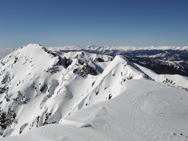
So in a more typical TR for me I would be dropping waypoints at all the noticeable features, drawing route lines onto photos, etc, etc. But since part of the appeal of this peak for me was not having that kind of detail, I'm going to strike a middle ground this time and give y'all just enough pictures and descriptions that you can grasp the overall scope and get a feel for the general difficulty level but yet not spoil all the route-finding fun with excessive beta. But there will be some "spoilers" below for anyone who wants the raw experience like I had it. 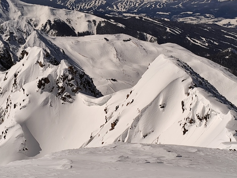
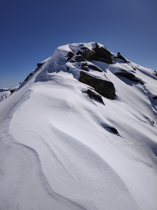
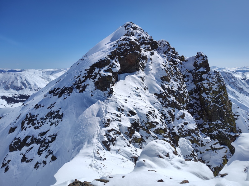
This is one of those peaks where, just walking over towards it my heart starts beating faster, my eyes widen and my jaw drops just a little. Dude, this is going to be sweet!!! 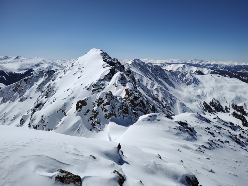
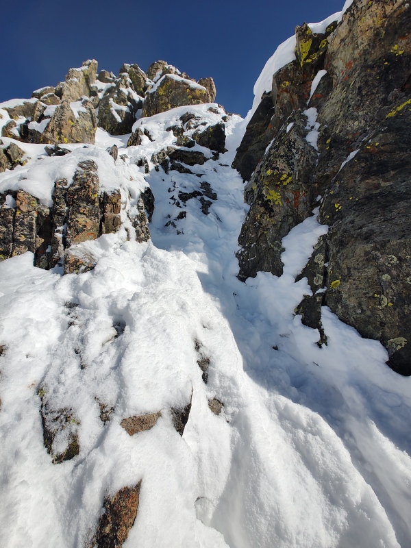
BETA This is where the "spoilers" start to really kick in. I intend to give enough detail for people to judge if this is something they want to try to tackle but stop short of fully giving away all the secrets of this fun route-finding maze. My idea is to give the flavor of the route, point out the major features and perhaps give at least some clues on how I tackled them but leave at least part of it to be figured out on your own. A lot of the beta will be in the captions so if you want to minimize spoilers then just look at the pictures and skip the captions. I will however highlight the avalanche danger in detail in a special follow-up section (see "The Replay and Analysis" section towards the end). 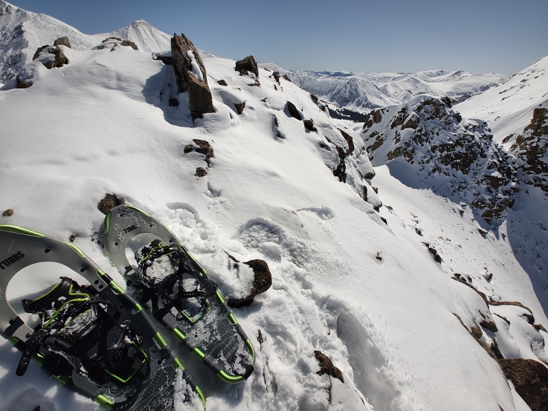
From Loveland Pass up until just before dropping down to the first saddle between Grizzly and Black you could just about do the whole thing with your hands in your pockets if you wanted to (depending on what extent you engage or divert around the small little scrambly features between Cupid and Grizzly). But this last little bit is going to make it so your hands are no longer bored. 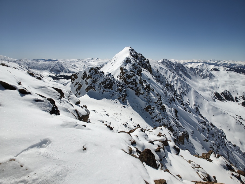
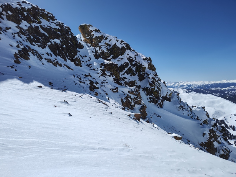
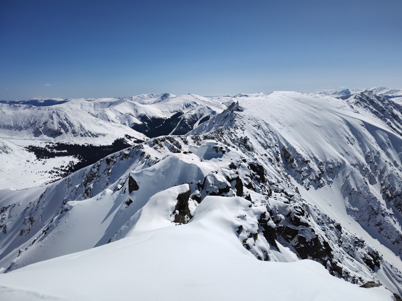
The below picture is one very key piece of evidence that will be revisited in "The Replay and Analysis" section towards the end. It's the main reason I was able to take the route I did and the only reason I'm not warning people wildly about the route. But the section towards the end will also explain why I'm not posting the GPX tracks for this particular winter route. 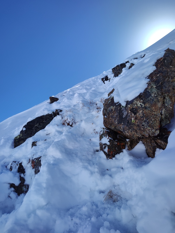
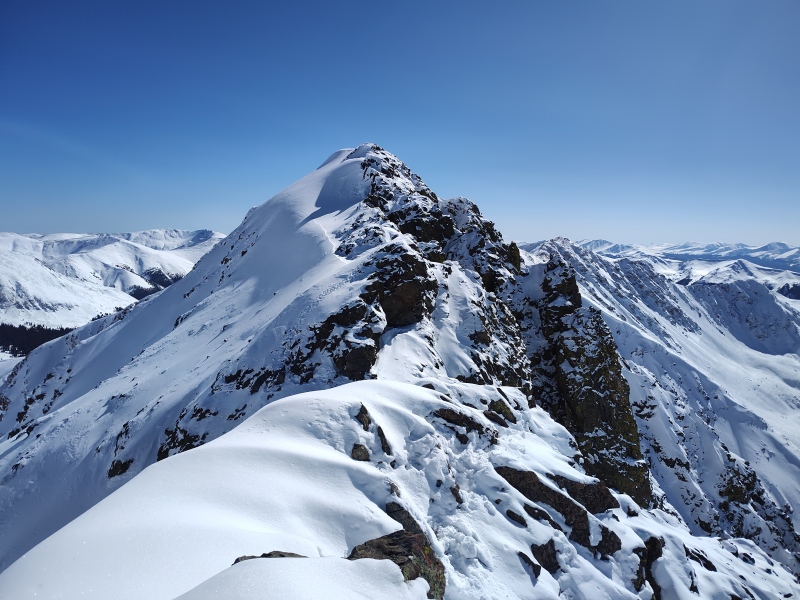
I think the below picture partly distorts the angle of things - I was pretty careful to always stay on or to the right of the rocks while coming down from Grizzly but if this image is not deceptive then I may have been closer to some of those cornices than I realized, especially just before the big rocky section near the bottom left. Yikes! 
I had already stopped near the summit of Grizzly to update my checklist since I was past all the dangerous stuff at that point and I was really eager about my silly little obsession to flip the zero to a one on the winter ascents. And, yes, someone's likely already done it without filling in the dates for it to register as a winter ascent, but if nothing else I'm still the first one to have filled in the boxes so I can at a minimum claim the first properly recorded winter ascent, whether or not it actually is the true first winter ascent. So yippee for me!!! I got a first on something! 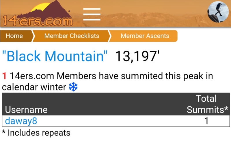
The Replay and Analysis So after I got home I was all excited to write up a cool trip report with a bunch of wicked looking photos and I was really curious to compare the wide angle shots from Grizzly with my close-ups coming and going in order to reconstruct the path I took. I also pulled up the photos from the first failed attempt to compare snow levels, etc. I though maybe I might possibly try to write up a route description for this peak. But as I slowly matched up rock features and figured out exactly where I had gone up to gain the ridge with respect to the wider mountain my jaw dropped and my eyes popped out! Then comparing the photos from my two trips I shuddered and cringed. Oh wow - am I seeing what I think I'm seeing?!? Brief interruption for dramatic suspense... Below is a topo map of the route. Note lots of really steep terrain near the end. The purple/black is often too steep to hold snow but the red is prime danger zone. Notice plenty of red just east of the summit... 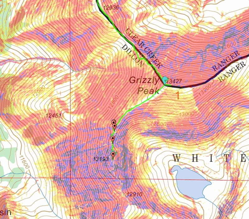
I then began dissecting all my photos, looking in detail at every little clue and asking myself if I was a total freaking lunatic to have gone up where I did. In the final analysis I concluded I was only mildly insane and not a total freaking lunatic. See, it turns out that I had made a couple steps on the first trip to start moving in the direction that I ended up taking on the second trip but then alarm bells started blaring in my head and I told myself I would probably die in an avalanche if I took a couple more steps. Weeeelllll... after examining photos from my first attempt on 2/17 and comparing them with similar photos from my successful trip on 3/9 I discovered that there appears to have indeed been an avalanche that swept exactly over that region in between my two trips. In fact, the only reason I was able to safely gain the ridge where I did was because that avalanche had ripped most of the snow off of the ridge before I arrived on my second journey. In the collage below you can see marked with big blue arrows (outlined in red) the signs of an avy path that wasn't there on 2/17. This is the path I'm nicknaming Dead Man's Slide. That avy path is what I went up on the second trip. Had I tried that before the built up snow had slid off I would have been swept over at least half a dozen exposed rock bands below and my body likely wouldn't have been found until next spring. This the nickname for that path. Now, granted, it's obvious from reading this that I hadn't yet realized all this as I was climbing. But here's why I still feel comfortable classifying myself as only mildly insane after making this realization. Although I wasn't positioned in such a way as to easily make these observations in the field, what I was able to do is to stay always only on, or at a minimum firmly gripping solid rock as I went out to those slopes where I knew there was high potential for avalanche danger (even though I didn't spot the debris of the slide from where I was at). Then the most critical piece of evidence I pointed out previously: when I carefully poked at the snow with my ice axe (by this time I had crampons locked onto mountaineering boots and ice axe in hand) I found grass hidden barely underneath the snow! I checked more spots and again found either grass or solid, stable rock. Based on how shallow the snow was and how firmly my crampons could dig into the exposed ground I felt that it was an acceptable risk to move out onto a slope where I could tell from the angle that it was prime avalanche territory. The steepest section was where there was grass just below the surface, then the angle eased up above there. Below are some key photos I compiled at home to show some of this analysis. 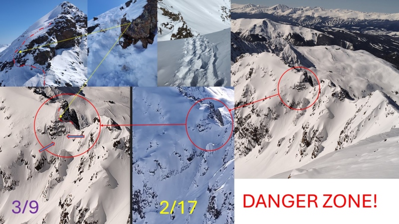
So in the end, I believe that the route I took was ultimately not excessively dangerous on the particular day and the particular conditions under which I did it since a previous avalanche had stripped most of the snow away, allowing me to safely gain the ridge with ice axe and crampons in this now snow-light section. However, if I had not stopped myself from taking a couple more steps in that direction on my first trip I would now be quite thoroughly dead - not "mostly dead" but "all dead." 
So How Long Did It Take? Well this is an ever present chagrin for me - every time I think I'm on my way to finally becoming Superman, it like, nope - ain't gonna happen dude. Just be happy you can still get'er done. I'll break it down by sections this time. 1st trip Loveland Pass to Grizzly: 3.5hrs 2nd trip Loveland Pass to Grizzly: 4hrs 56min (layered poorly, froze, tried to speed up, bonked, had to stop and layer up/warm up, dealt with greater snow than 1st trip, etc) 1st trip Grizzly to almost Black Mountain: 2hrs 20min 2nd trip Grizzly to Black Mountain: 3hrs 3min 1st trip almost Black Mountain to Grizzly: 1hr 14 min 2nd trip Black Mountain to Grizzly: 1hr 58min 1st trip Grizzly to Loveland Pass: 3hrs 12min 2nd trip Grizzly to Loveland Pass: 2hrs 51min 1st trip total time: 10hrs 49min 2nd trip total time: 13hrs 9min (and yes, that's for a total of only 6.5 miles round trip - but the hilarious thing is, if it's confirmed that no one else has yet done this peak in winter then this would be the Fastest Known Time for a winter ascent of Black Mountain - I'm going to have to pick myself off the floor laughing now...) The bar has been set really low on this one folks... But one interesting tidbit here is that I started really lame on the first segment of the 2nd trip but I ended much stronger on the final segment of that last day! Woohoo - finish strong!!! Thumbnails for uploaded photos (click to open slideshow): ")
")
")
")
")
")
")
")
")
")
")
")
")
")
")
")
")
")
")
")
")
")
")
")
")
")
")
")
")
")
")
")
")
")
")
")
")
")
")
")
")
")
")
")
")
")
")
")
")
")
|
| Comments or Questions | |||||||||||||||
|---|---|---|---|---|---|---|---|---|---|---|---|---|---|---|---|
|
Caution: The information contained in this report may not be accurate and should not be the only resource used in preparation for your climb. Failure to have the necessary experience, physical conditioning, supplies or equipment can result in injury or death. 14ers.com and the author(s) of this report provide no warranties, either express or implied, that the information provided is accurate or reliable. By using the information provided, you agree to indemnify and hold harmless 14ers.com and the report author(s) with respect to any claims and demands against them, including any attorney fees and expenses. Please read the 14ers.com Safety and Disclaimer pages for more information.
Please respect private property: 14ers.com supports the rights of private landowners to determine how and by whom their land will be used. In Colorado, it is your responsibility to determine if land is private and to obtain the appropriate permission before entering the property.


