| Report Type | Full |
| Peak(s) |
Longs Peak - 14,259 feet |
| Date Posted | 01/04/2024 |
| Date Climbed | 01/02/2024 |
| Author | nifb22 |
| Longing for winter on Longs |
|---|
|
Longs Peak is the unmistakable feature that dominates the view for those living or passing through the front range particularly on clear days as it sits prominently above the surrounding mountains. Most are content with ticking it off as a relatively challenging summer adventure and calling it a day then for winter heading to groomed ski resorts while admiring Longs snowcapped peak from afar. During mid-2022 I decided to start tackling winter 14ers, and senselessly thought Longs would be a good choice which thankfully I never succeeded nor ever suffered more than a bruised ego as I was thwarted at least 8 different times. Much was learned as I did more winter adventures during the 22/23 winter season, and fast forwarding to 1 January 2024 a window of opportunity opened. That Monday I had just bagged Mount Bierstadt and was feeling on a high with how amazing the weather had been as well as the snow conditions. Jumping on CAIC that afternoon the front range had moved into green for avy conditions, and checking mountain forecast the beautiful conditions were predicted to continue Tuesday hinting to me that it was time. 2 January 2024. I had managed to get just over 4 hours of sleep after doing Mount Bierstadt the day before and was at the Glacier Gorge car park around 2am. It was a calm morning as forecasted with temps sitting at 20f for the trailhead elevation with temps topside expected to be single digits with winds no greater than 10mph. With almost everyone having had a three-day weekend for the New Years and weather over the weekend being just right for the average person to get out there had been a huge amount of foot traffic on the Glacier Gorge trail. Before going further though I should take a moment to outline the objective I had in mind. My goal was simple. I wanted to connect Glacier Gorge with the Boulder Field utilizing Longs Peak and with zero doubling back even to do the Keyhole Route-though during winter Keyhole ledges can be quite dangerous. Of course, to accomplish this means two things first being that to get up from the gorge floor would mean using the trough and secondly getting down would mean taking cables route. To do cables and being someone that is very uncomfortable with any form of downclimbing without a rope meant having to carry rope as well as necessary extras up with me. Back in my car sitting at the empty trailhead I double checked all my gear and got myself dressed to start out on what I correctly assumed would be the easiest leg of the journey. With all the three-day weekend foot traffic on the Glacier Gorge trail it was a beautifully smooth 4.5-mile journey to Black Lake with nothing eventful to discuss further. At Black Lake was when the fun would begin. I maxed out my headlamp to get a vague idea of how the climb up looked and saw occasional boot track but otherwise couldn’t tell if it was consolidated or powder from down below. Knowing that there was a stream that runs into Black Lake I opted to don crampons in case there was any ice hiding in the snow. To my astonishment even without a huge amount of foot traffic the snow had consolidated and was firm enough to support me except in a few random spots. Making good time I was able to cruise up and began loosely following the Frozen Lake trail to get me below the trough. After getting roughly on the trail and using moonlight to find a point of reference to fixate upon I began moving along the just over quarter mile I had remaining to get to the trough start point. 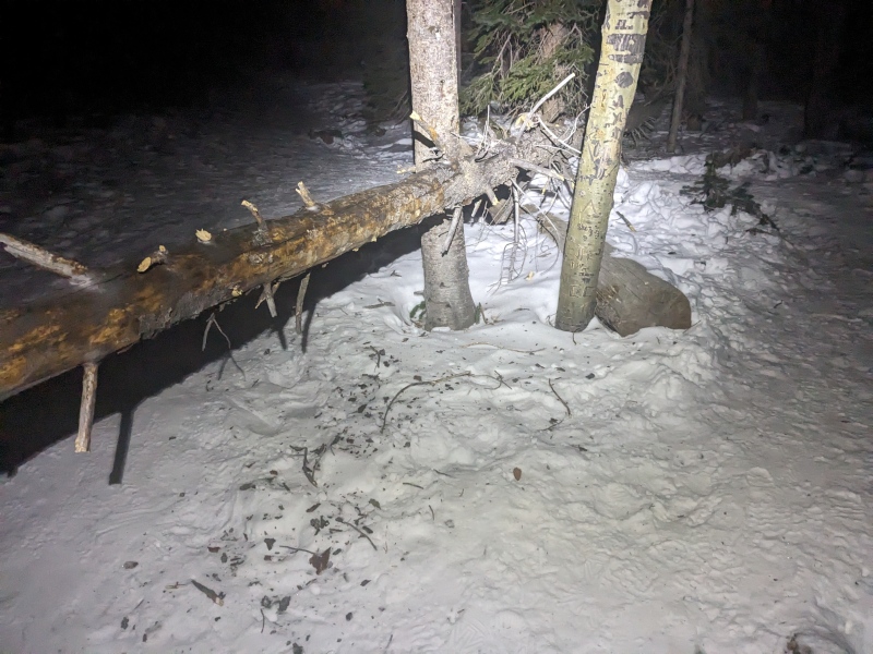
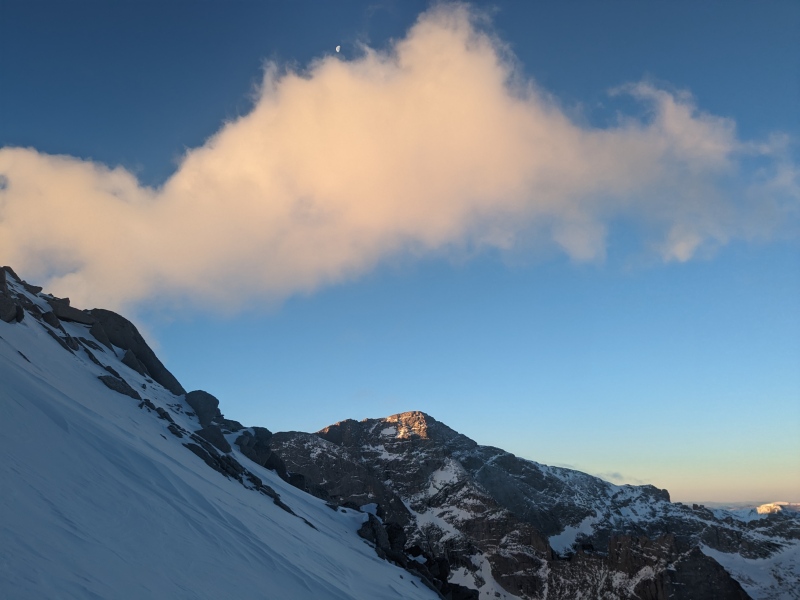
This short distance to the start was as expected with occasional willows, some rock outcroppings to navigate around and some odd sheets of ice I can’t figure out how they formed. At last, however, I was at the mouth of the trough and nearly perfectly timed with it nearing 5:45 meaning I would soon be getting daylight to help guide me. Even without the sun I could clearly make out the flattop of Longs and could use that to draw a reasonable assumption where the narrows were and from there follow that down to the trough. As I started up the trough, I was quite surprised to see boot traffic with it at times disappearing when that person or party was able to get on the rocks. I opted to follow that path in the rocks for a bit as I assumed the trough to likely be powder which I later found out to be a very incorrect assumption. I left the rocks only due to wanting to get further right to better line-up with the trough proper above, but again I was amazed to find consolidated snow. Sticking to dead-center to avoid rocks I was able again to cruise up the lower portion of the trough. There was a rock shelf of sorts midway between the start and the Longs peak trail above which appeared to run the width of the trough and required a bit of work to get over. This shelf only slowed me down by about 5 minutes, and after that there were no additional obstacles other than there being sections of snow so firm it was quite laborious to get sufficient points in to secure myself. I should note I had only my Petzl Summit axe with me, I do have a BD raven that might have been beneficial to maintain three points of contact but with my anticipated distance the weight wasn’t worth it. Just before arriving at the Keyhole route was when I saw McHenrys light up as the sun was high enough to cast over Longs onto the westside of Glacier Gorge. I kept eagerly looking up in anticipation of seeing some bullseye targets on rock, and finally at around 13,200ft I saw my first target feeling a renewed sense of energy I pushed up to find a relatively dry rock to rest on. With the sun out looking up I was now able to clearly see the trough, and a very surprising sight which was that there had been a substantial amount of foot traffic on the Keyhole route. It seems not as many people are as discouraged by traversing the ledges as I thought. Now on route and with a lot of boot pack to follow having taken a break I set off being able to quickly move through by following a well-established path that navigated me up and out of the trough to the narrows. 
Narrows. My first time in the sun and I could feel it warming me after having been either in the dark or shade these past 6 plus hours. Again, with the previous foot traffic the path ahead was clear, and the snow had firmed up overnight giving my crampons plenty of opportunity to get good purchase to keep me from sliding off. Knowing how it was during the summer the thought of what I was standing on did spook me a bit as I moved along towards the homestretch over and between some rock obstacles which didn’t present any issues. 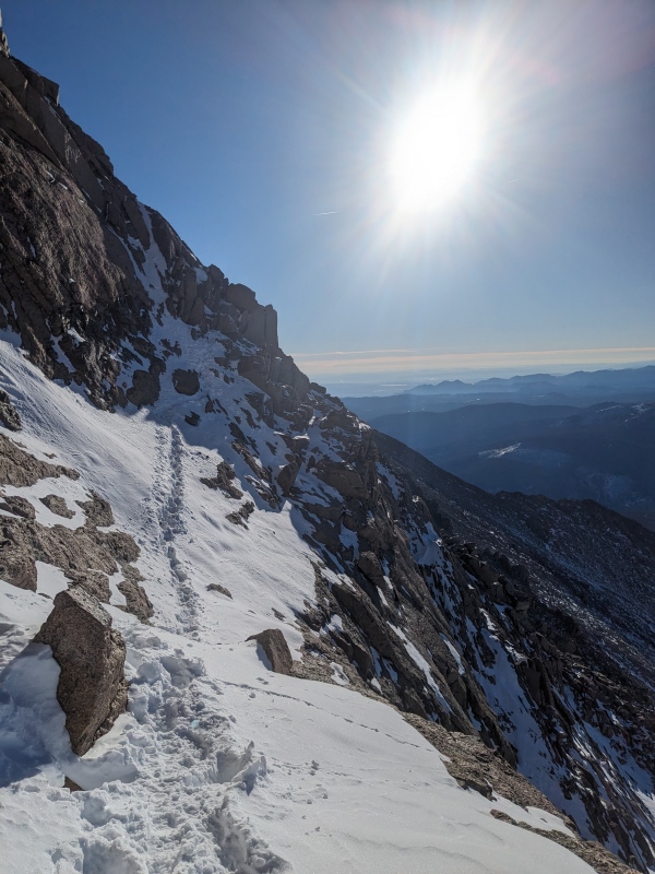
It was finally time, and what I had the greatest apprehension about. I arrived at the base of the homestretch and was able to breathe a sigh of relief as it was surprisingly well covered with snow providing a chance for my front points to do their job. I took a short five at the base then pushed off with their initially being a large rock outcrop to use as a handhold, but quickly I went above this leaving me nothing to grab hold of. At times to give myself greater peace of mind I would use the adze on my axe to tidy up the steps and give myself a deeper more secure footing. Feeling the weight of my pack plus the altitude I took a couple brief 1–2-minute breaks as I moved along the 500 or so feet that is the homestretch. 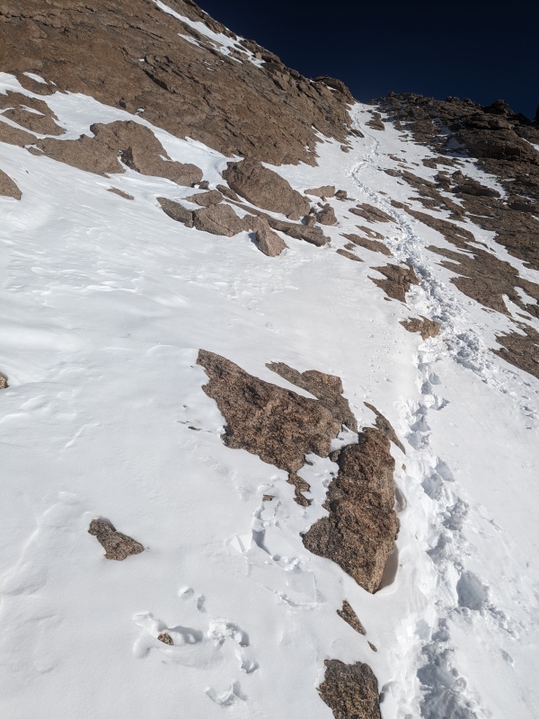
After countless hours of driving and hiking during the 22/23 winter season I had finally done it! I arrived at the summit of Longs during calendar winter though quickly my elation died out as I felt as if a lot of sick was about to come up and out of me. Thankfully sitting down and sipping some water calmed my stomach giving me an opportunity to take in this perfect day. The wind occasionally picked up to the forecasted max of 10mph, but mostly it was calm with no clouds to prevent the sun from warming me up. I had failed to put my bottle back inside my jacket after an earlier break, so my water was running low and was all nearly frozen having brought a stove I was able to melt some rocky snow. Enjoying some celebratory chocolate fudge, which I had carried up with me, I waited for water to boil, it was as the cliché goes which was that of being a surreal moment. With all my prior failures and misadventures to attain this it was with a deep sense of satisfaction I sat there though this was all short lived as now I had to navigate the section of this hike I had never done before. 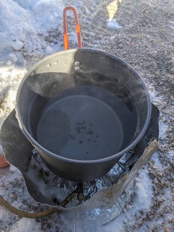
Cables. After making some water and consuming some calories my next order of business was sort out my rap gear as I knew that descending would be a bit of 4th class scrambling before getting to the third bolt to rappel off. As mentioned, I have never been on cables, I have been to Chasm View and looked up the route but the exact route to get to the third bolt was a huge unknown. Yet again though I found myself surprised that there was also foot traffic on this route as well. However, after starting the descent I quickly was able to see where Chasm View was down below which meant drawing an imaginary line from there, I could roughly pinpoint my ultimate destination. My scramble down this 4th class section wasn’t terribly interesting with only a couple downclimbs that required some consideration for others I was able to navigate around. Stopping every few minutes I kept tabs on my heading, and after that second downclimb I finally saw the third bolt poking its eye out just above the dihedral below. Of note is that most of this descent was just with boots, but nearing the bolt it did get slippery plus now I could see below some potentially dicey conditions at the bottom of Cables. Finding a flat rock, I put crampons back on, and safely pushed the 100ft to get to the bolt to setup my rappel. I’m not sure how it slipped my mind, but I had only brought one sling and not two as I likely should have. My carabiners were all too small to use on that large bolt and so a second sling would have allowed me to girth hitch to them however lacking that I ultimately just straddled the bolt. With the bolt between my legs and nothing to keep me from sliding into the abyss below I carefully took the rope from off my pack to begin flaking it out. Once the rope was out it was all pretty straightforward from there to get myself connected into the system while ensuring that I had put stoppers knots on either end just in case. After a triple check I shimmied myself around to below the bolt and started my descent down. Other than that, initial downclimb below the third bolt it was all just a long slab to walk backwards on and might not be that bad to do without a rope for most, but my comfort level isn’t there yet having only recently started climbing or doing anything above Class 5. My rope at 50m would about get me to the first bolt, but out of an abundance of caution and more practice I opted to stop at bolt 2 to pull through my rope then set it up for a second rap. I tied into bolt 2, but again it was a low angle slab that I could stand on without much issue which is what beta for Cables Route indicated that the steepest portion was the top third of the route. However, I carried that rope with me and for that reason alone it was going to get used even if it wasn’t necessary. Rappelling from bolt 2, I got myself down without issue to a nice landing area at the base of Cables and cleaned everything up for some further scrambling. 
The landing area below the first bolt is big and comfortable, but getting to Boulderfield was a bit trickier in the snow than I had anticipated. There is an initial slab to descend, and the snow was thin leading to it being slippery, but after about 10-15ft I was at a point where I was comfortable removing my crampons since I could move across the rocks while putting them away, I grabbed out my axe. There wasn’t ice to worry about at this point, but I find it useful for balancing myself on boulders. From here on out there isn’t much to be said. I worked my way through the boulders heading towards the loo since I knew from there, I could catch the trail out. There was plenty of traffic from than on so following it to the switchbacks then eventually to storm pass was uneventful. One thing to take note of however is that North Longs Peak trail sees very little traffic and had got a huge snow dump onto it at some point during December. The remaining 6 or so miles to get back to Glacier Gorge trailhead was just total misery, and with no quicker way out I was forced to trudge through snow drifts that often were 2ft deep with zero consolidation or firmness. Just past Boulder Brook sites I took one last photo as nighttime descended upon me and I had to continue the awful journey of wading through the snow. 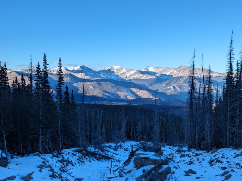
All in all, this was an amazing day, and a route I would recommend to those that like big days out or just want an alternative take on doing Longs. As mentioned by others when discussing the trough doing this route summertime would be ill-advised as the danger of rock-fall would be at an extreme level with all the traffic above. My next point is that likely a shorter rope could be carried possibly down to 30m depending on a person or parties comfort level especially if the only concern is getting below the 3rd bolt to downclimb from there. Reading other reports, it seems most people doing Longs in the winter just make it an out and back on either side for example skiing to the trough booting up, and coming back down it. 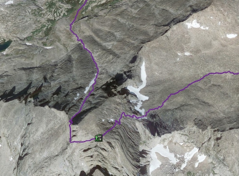
Thumbnails for uploaded photos (click to open slideshow): ")
")
")
")
")
")
")
")
")
|
| Comments or Questions | ||||||
|---|---|---|---|---|---|---|
|
Caution: The information contained in this report may not be accurate and should not be the only resource used in preparation for your climb. Failure to have the necessary experience, physical conditioning, supplies or equipment can result in injury or death. 14ers.com and the author(s) of this report provide no warranties, either express or implied, that the information provided is accurate or reliable. By using the information provided, you agree to indemnify and hold harmless 14ers.com and the report author(s) with respect to any claims and demands against them, including any attorney fees and expenses. Please read the 14ers.com Safety and Disclaimer pages for more information.
Please respect private property: 14ers.com supports the rights of private landowners to determine how and by whom their land will be used. In Colorado, it is your responsibility to determine if land is private and to obtain the appropriate permission before entering the property.


