Download Agreement, Release, and Acknowledgement of Risk:
You (the person requesting this file download) fully understand mountain climbing ("Activity") involves risks and dangers of serious bodily injury, including permanent disability, paralysis, and death ("Risks") and you fully accept and assume all such risks and all responsibility for losses, costs, and damages you incur as a result of your participation in this Activity.
You acknowledge that information in the file you have chosen to download may not be accurate and may contain errors. You agree to assume all risks when using this information and agree to release and discharge 14ers.com, 14ers Inc. and the author(s) of such information (collectively, the "Released Parties").
You hereby discharge the Released Parties from all damages, actions, claims and liabilities of any nature, specifically including, but not limited to, damages, actions, claims and liabilities arising from or related to the negligence of the Released Parties. You further agree to indemnify, hold harmless and defend 14ers.com, 14ers Inc. and each of the other Released Parties from and against any loss, damage, liability and expense, including costs and attorney fees, incurred by 14ers.com, 14ers Inc. or any of the other Released Parties as a result of you using information provided on the 14ers.com or 14ers Inc. websites.
You have read this agreement, fully understand its terms and intend it to be a complete and unconditional release of all liability to the greatest extent allowed by law and agree that if any portion of this agreement is held to be invalid the balance, notwithstanding, shall continue in full force and effect.
By clicking "OK" you agree to these terms. If you DO NOT agree, click "Cancel"...
I made it to the Bandora Mine the day before, and spent the day scouting potential routes.
In the evening I did a little catch and release fishing, the beavers came out of their lodges, and I saw one tail flip a coyote who got too close.
Beaver and Coyote:
Then a bull moose came strolling around, and I went to bed. I was on the trail at 6:30am the next morning. I took the trail to Lake Hope, which started just to the south of the parking area.
I took this class 1 trail southwest for about .8 miles.
At around 11160’ of elevation I left the trail, and turned right. If you get to the Big Three Mine you’ve gone too far. I placed a cairn here, and headed north.
I bushwhacked north up the mountainside to treeline
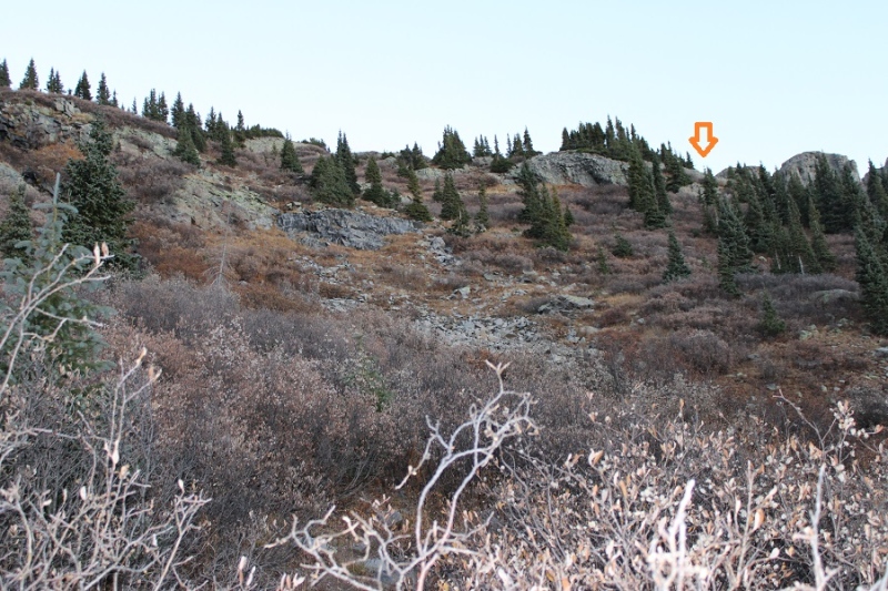
I was headed here, which included some willow navigation. I found if I stayed high I could follow game trails.
Once I could see this ridge I turned left and headed northeast to a basin
I kept heading northeast, as the tundra changed over to talus
Now in the upper basin, I aimed for the Beattie/Fuller Saddle.
I stayed to the left of the snow, and found the talus was surprisingly stable.
Once at the saddle, I turned left and followed the class 2 ridge to Beattie Peak
I summited Beattie Peak at 8:45am
Beattie Peak:
I could see PT 13302 to the southwest.
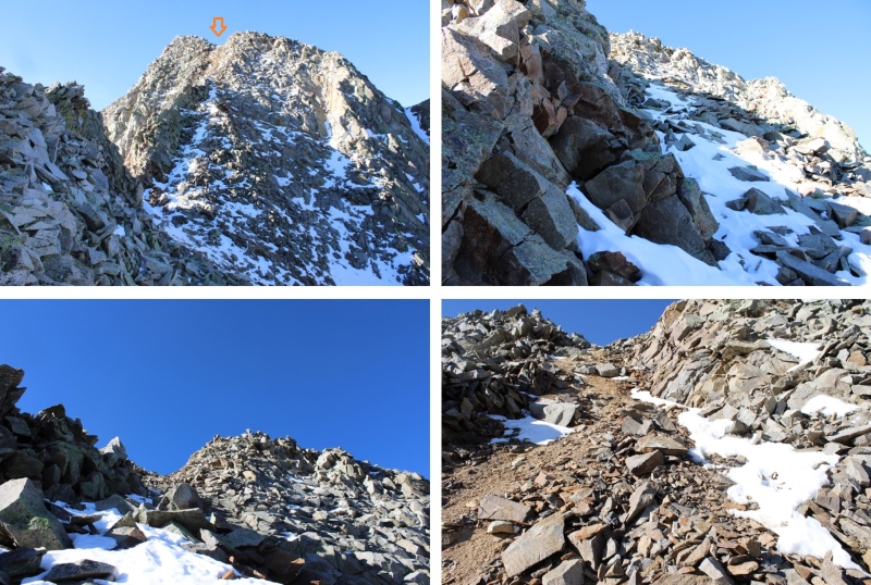
Now is a good time to put your helmet on. This is a class 3 ridge, but starts out as class 2. This is the overall route I took to get there, taking the ridge to a gully.
The initial descent of the ridge is class 2
But quickly becomes narrow, sustained class 3 with exposure. The ridge proper goes at class 3, but twice I dipped down to the left to avoid the exposure involved. Here are some pictures of the ridge
I was now at the base of the gully. Microspikes helped here.
This is the route I took
And some pictures of the gully
At the top of the gully I went right
And then I could see the final approach to the summit
This is the overall route I took to the summit
There were two summit cairns, each about 15 feet apart. They looked to be of equal height.
I summited PT 13302 at 10am
PT 13302:
I know the traditional way to descend from PT 13302 is to head southwest and down to the V9/PT 13302 saddle, but I’d been there the day before, and did not want to descend that way. Instead, I headed southwest towards a small saddle, then turned left and scree-surfed south.
This route brought me back to the Lake Hope Trail.
Here’s looking up at the route I scree-surfed down
Back on the Lake Hope trail, I followed it east back to Bandora Mine
I made it back to Bandora Mine at 11:45am, making this a 6.87 mile hike with 2945’ of elevation gain in 5 hours, 15 minutes.
On to the next trailhead!
Thumbnails for uploaded photos (click to open slideshow):
Comments or Questions
Caution: The information contained in this report may not be accurate and should not be the only resource used in preparation for your climb. Failure to have the necessary experience, physical conditioning, supplies or equipment can result in injury or death. 14ers.com and the author(s) of this report provide no warranties, either express or implied, that the information provided is accurate or reliable. By using the information provided, you agree to indemnify and hold harmless 14ers.com and the report author(s) with respect to any claims and demands against them, including any attorney fees and expenses. Please read the 14ers.com Safety and Disclaimer pages for more information.
Please respect private property: 14ers.com supports the rights of private landowners to determine how and by whom their land will be used. In Colorado, it is your responsibility to determine if land is private and to obtain the appropriate permission before entering the property.


")
")
")
")
")
")
")
")
")
")
")
")
")
")
")
")
")
")
")
")
")
")
")
")
")
")
")
")
")
")
")
")
")
")
")
")
")
")
")
")
")
")


