Download Agreement, Release, and Acknowledgement of Risk:
You (the person requesting this file download) fully understand mountain climbing ("Activity") involves risks and dangers of serious bodily injury, including permanent disability, paralysis, and death ("Risks") and you fully accept and assume all such risks and all responsibility for losses, costs, and damages you incur as a result of your participation in this Activity.
You acknowledge that information in the file you have chosen to download may not be accurate and may contain errors. You agree to assume all risks when using this information and agree to release and discharge 14ers.com, 14ers Inc. and the author(s) of such information (collectively, the "Released Parties").
You hereby discharge the Released Parties from all damages, actions, claims and liabilities of any nature, specifically including, but not limited to, damages, actions, claims and liabilities arising from or related to the negligence of the Released Parties. You further agree to indemnify, hold harmless and defend 14ers.com, 14ers Inc. and each of the other Released Parties from and against any loss, damage, liability and expense, including costs and attorney fees, incurred by 14ers.com, 14ers Inc. or any of the other Released Parties as a result of you using information provided on the 14ers.com or 14ers Inc. websites.
You have read this agreement, fully understand its terms and intend it to be a complete and unconditional release of all liability to the greatest extent allowed by law and agree that if any portion of this agreement is held to be invalid the balance, notwithstanding, shall continue in full force and effect.
By clicking "OK" you agree to these terms. If you DO NOT agree, click "Cancel"...
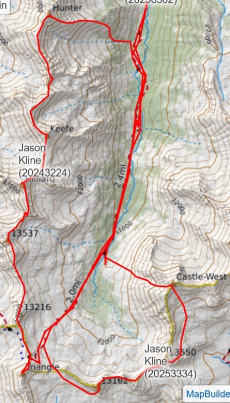
Route overview of both days. Thanks Jason for sharing your track since Gaia was acting up for me.
Schedules, partners, weather, and a permit aligned with the objective of climbing the nine 13ers in the Conundrum basin. It felt like winning the lottery to find a permit for Conundrum Hot Springs, just 4 days prior.
On Monday, 8/28, Jason, Marshall and I met at Conundrum trailhead at about 1230 and backpacked for about 4 hrs (8 miles and 2,900’ gain) on a pleasant trail to the our permitted site #15.
On Tuesday, 8/29, we climbed the 6, 13ers from Triangle to Hunter, taking 16 hrs to complete—starting and ending the day with headlamps. We found the traverse more time consuming than anticipated with plenty of class 3 and 4 scrambling on loose rock. Thankfully we had excellent weather. All the previous trip reports I read
start from Hunter and connect the ridge to Triangle (and more). Others split up the peaks in smaller segments. I support our route choice given our fortunate campsite, however it was much longer than anticipated.
From camp, we followed the straight-forward trail through the willows and tundra to Triangle pass near 13,000’ gaining 1,860’ in about 2 miles. From there, we climbed another ~370’ to the summit of Triangle Peak on a decent climbers trail through the blond-colored loose rock. Back down at Triangle pass, we connected the ridge to the maroon-colored UN 13216 which was mostly class 2 with maybe a few easy class 3 moves. Next up, came UN 13537, which had a fun, blocky scramble at the top. Now halfway through the peaks, we still had a taxing and seemingly increasingly crumbly ridge to route-find. We pushed on to Hilliard, still with excellent weather and views. Keefe to Hunter is truly 2 miles apart with tedious, loose class 3, 4 and bypasses of pointy ridge lines. Déjà vu. Finally we made it to Hunter, our 6th peak of the day. In the remaining daylight, we descend the steep east ridge and bush-wacked down through the aspens and willows to the trail at 10,280’. Finally, and we cruised 2.5 miles up the lovely trail wearing headlamps to camp.
looking back at the morning light
from Triangle pass, looking back at Triangle Peak
5 more to go for the day!
fun scramble up UN 13537
gully below UN 13537
crumbly mess up to Hilliard
view from Hilliard
enjoying the views from Hilliard
leaving Keefe, off to Hunter
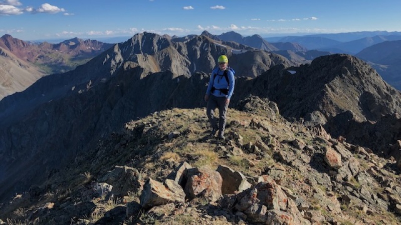
finally to Hunter, 6th peak of the day (photo credit: Marshall)
8/29 times:
0535 started from camp
0735 Triangle Peak
0900 UN 13216
1100 UN 13537
1245 Hilliard
1410 Keefe
1800 Hunter
2130 return to camp
On Wednesday 8/30, we slept in and started from camp at 0715 with our objective to climb the remaining 3 13ers in the Conundrum basin: UN 13162 B, UN 13550, and Castleabra. We repeated the trail through the willows towards Triangle pass, but departed the trail at 12,570’ and veered left to Coffeepot pass. After descending the south side of Coffeepot pass, we rock-hopped and contoured along 12,600’ for about half a mile. Then we ascended the loose gully to a class 3 and 4 scramble on classic Elk-mess to the summit of UN 13162 B. From the summit, we watched two mountain goats jump along the precarious cliffs below with rocks crashing in tow. If only we were so competent!
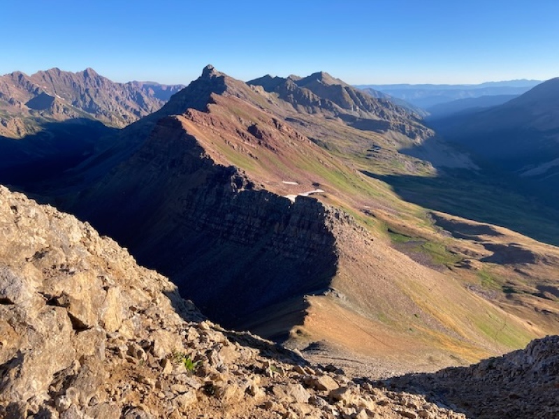
From UN 13162 B, we connected the class 3 ridge to ruby-colored UN 13550 with a few minor bypasses along the way. Weather continued to look stable, so we carried on. We elected not to try connecting the ridge from UN 13550 to Castleabra. Rather, we dropped along the rocky and partially grassy southeast ridge and curved north to navigate left of a cliff band at around 13,000’. We descended further into the upper, grassy Cumberland basin as low as 12,600’. After discussing the ascent route up Castleabra, we eyed a left-angled line up from a short grassy patch to the gully below of a blond-colored saddle. From there, we climbed the short, steep southwest ridge to the summit of Castleabra. We signed the summit register and ate a snack. With lengthened trekking poles, I took off first to space out the dreaded descent of the west-facing gully. The goal being not to take out your hiking partner. We knew of its terrible reputation, and it was just as bad as stated. Where I could, I scree-surfed the mostly 35 degree slope, kicking up a good deal of dust. The sound of scree and talus rockfall got the attention of the hot spring-soakers below. The 2,300’ descent in 0.8 miles conveniently ended at the hot pool where we enjoyed a well-deserved soak with some friendly people. A snow climb of Castleabra is what I will recommend to friends.
morning view of UN 13550 (left) and UN 13162 (right)
we went left of the snowfield, up Coffeepot Pass
the traverse down and around to the south side of UN 13162
final scramble to UN 13162
the goats showing off below us
ridge to UN13550 (red one in center)
closer view of UN13550
Castle Peak. Good name!
looking back at the SE ridge of UN 13550 that we descended
Castleabra (right) and the left-angled line we ascended, taking advantage of the grass in center
near the summit of Castleabra, looking back the ones we climbed: UN13550 (left) and UN 13216 (right)
Jason is the small dot with a yellow helmet at the top
the hot springs are coming into view!
full view of the wretched Castleabra west gully
8/30 times:
1030 UN 13162 B
1240 UN 13550
1515 Castleabra
1700-1800 soak in Conundrum hot spring
My GPS Tracks on Google Maps (made from a .GPX file upload):
Skimo95-- Thanks! It was my first trip report. I now have a better appreciation of the work people put into writing them.
Jason-- haha, no need to apologize. No worries about adding Castleabra. I fully agreed to it and I'm glad we climbed it while we were there.
Caution: The information contained in this report may not be accurate and should not be the only resource used in preparation for your climb. Failure to have the necessary experience, physical conditioning, supplies or equipment can result in injury or death. 14ers.com and the author(s) of this report provide no warranties, either express or implied, that the information provided is accurate or reliable. By using the information provided, you agree to indemnify and hold harmless 14ers.com and the report author(s) with respect to any claims and demands against them, including any attorney fees and expenses. Please read the 14ers.com Safety and Disclaimer pages for more information.
Please respect private property: 14ers.com supports the rights of private landowners to determine how and by whom their land will be used. In Colorado, it is your responsibility to determine if land is private and to obtain the appropriate permission before entering the property.


")
")
")
")
")
")
")
")
")
")
")
")
")
")
")
")
")
")
")
")
")
")
")
")
")
")


