Download Agreement, Release, and Acknowledgement of Risk:
You (the person requesting this file download) fully understand mountain climbing ("Activity") involves risks and dangers of serious bodily injury, including permanent disability, paralysis, and death ("Risks") and you fully accept and assume all such risks and all responsibility for losses, costs, and damages you incur as a result of your participation in this Activity.
You acknowledge that information in the file you have chosen to download may not be accurate and may contain errors. You agree to assume all risks when using this information and agree to release and discharge 14ers.com, 14ers Inc. and the author(s) of such information (collectively, the "Released Parties").
You hereby discharge the Released Parties from all damages, actions, claims and liabilities of any nature, specifically including, but not limited to, damages, actions, claims and liabilities arising from or related to the negligence of the Released Parties. You further agree to indemnify, hold harmless and defend 14ers.com, 14ers Inc. and each of the other Released Parties from and against any loss, damage, liability and expense, including costs and attorney fees, incurred by 14ers.com, 14ers Inc. or any of the other Released Parties as a result of you using information provided on the 14ers.com or 14ers Inc. websites.
You have read this agreement, fully understand its terms and intend it to be a complete and unconditional release of all liability to the greatest extent allowed by law and agree that if any portion of this agreement is held to be invalid the balance, notwithstanding, shall continue in full force and effect.
By clicking "OK" you agree to these terms. If you DO NOT agree, click "Cancel"...
Another Beautiful day in the high country, another amazing hike with friends, and another realization that I am not is as good of shape as I thought.
The office I work in has some amazing people in it and quite the hiking community. After a few years of not bagging any new 14ers, I needed to get on the horn, get myself into shape, and go on a hike with some coworkers. After a couple repeat 14ers and a 13er I thought I was ready. Tabeguache West Ridge was my idea. I had done Shavano before and wanted to get Tab without having to do Shavano again. A bit of research on 14ers told me that its west ridge was very doable. A couple of water cooler conversations later and I had two coworkers to go with me.
We decided to drive up the night before and car camp. Got to the trailhead around 7 PM and quickly got situated. Was greeted to a beautiful view of valley. Decided to call it a night around 8:30 and went to bed. Was a clear night and the stars were amazing. Saw some shooting stars in the August night and fell asleep pretty quick which is rare for me before a hike.
The North Fork South Arkansas River Valley at Sunset
A note on the road: The road report on 14ers.com is very accurate. This is a level 3 road. I put my car into 4 low, probably didn't need to but it has some rough spots. Taking it slow and finding the right lines was able to avoid scraping on my Jeep Cherokee Trailhawk. One friend made it easy in a 4Runner, another made it in an older Acura MDX. He was struggling though.
Start of the Hike
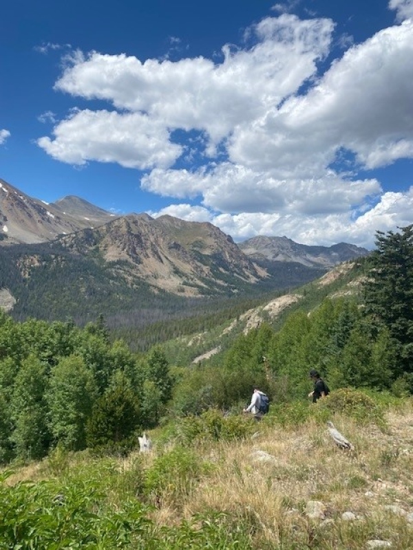
We decided to get going at about 5:45 in the morning and started heading up the trail. The first mile or so is a great warmup. Following the better-than-expected trail, you gain close to 800' in about a mile and finally make it into the valley.
First Views into the Jennings Creek Valley
We got up into the basin right around sunrise at 6:20 am and had our first views of this amazing valley and the sun rising behind us.
Sunrise on Taylor MountainThe Weave
Continuing onwards myself and the group were in high spirits. There were a few trails to choose from but we decided to follow the cairns and stuck closer to moraine on the East side of the valley than to follow the other trail into the willows. This easy terrain continues for a while and the entire time the group was laughing and joking as we steadily gained elevation. Nearing the end of the valley we got a glimpse of what lied ahead of us.
It was at this point of enjoying the hike that one coworker went "I'm so happy to be here, thanks for bringing me". She would soon retract that statement. Gaining the ridge was not too bad, the stretch of 200' of steep gravel was a slog but going up it was not bad. How I would hate that stretch coming down. But, we were on the way up and we were making good time so we soon forgot about that and enjoyed our first views out of the valley.
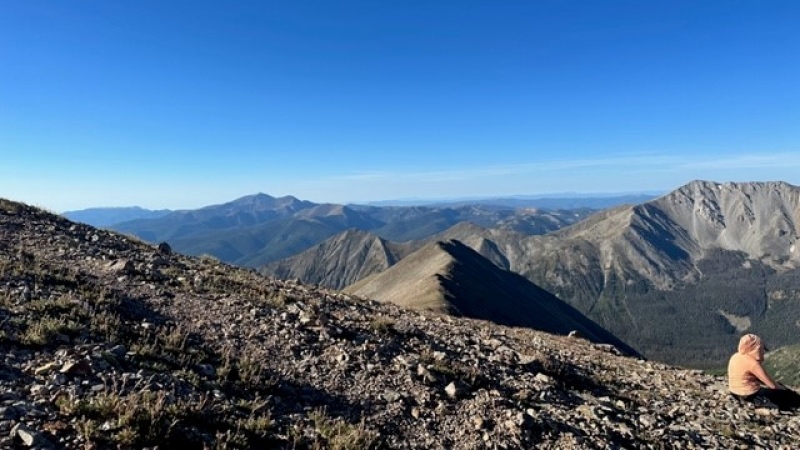
Carbonate to our WestAntero to the NorthAnd Point 13,936 to our East
Getting to the Saddle at 7:45 am we were gifted by having a nice and shaded route. This continued till just before reaching the top of 13,936. This stretch though, started to sap the group moral a bit. It's a long steady gain from 12,600' and we all got a tad quiet as we made our ascent. The packed talus is pretty solid footing the entire way but it's a ways. Again, thank goodness we had the shade!
Just below 13,936 we took a break and applied sunscreen.
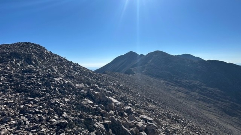
Just below the top of this "bump" we could finally see what we had left, and I was getting excited. Most of the vertical was done for the day, just some shallow class two ridges to go.
Tab in all its glory
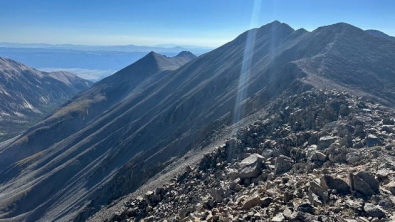
After a little refueling the group started to make our way across the ridge. Following the ridge, a nice trail had been worked into it and the footing was great. 150' down and about 300' up to go. Basking in the glory of sunshine, "Another Day in Paradise" by Quinn XCII playing in my head, we were high on life.
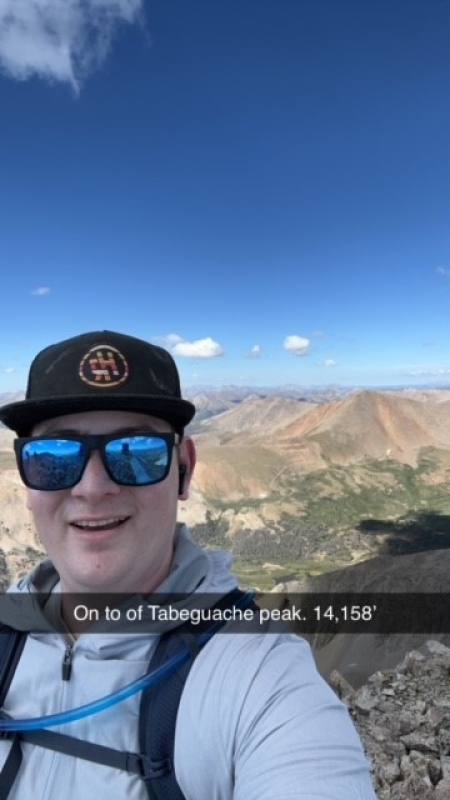
Just before the summit there is a stretch where one should leave ridge proper and skirt to the south to gain the final pitch to the summit. On top we saw mostly people taking the same route as us, guess we summited before the people heading over Shavano made it over. Summited at 9:40 AM. Finally got another one.
Enjoyed talking with everyone and taking pictures. Ate some more and life was good. Taking about 20 minutes on top to bask in the glory, we finally turned around and started to head down. Everyone in the group was feeling alright on the ridge walk back to point 13,936. Changing perspective showed us some routes around the high point that we could avoid that we had not seen going up. But eventually we had made it to the end of the high ridge and needed to start the main descent down to the saddle.
Starting the steep descent.
This bit is where I really learned I am not in the best shape ... Yet. Legs started to get tired, hips started to flare with the steepness, and the rock I though was great coming up was now threatening to twist ankles while coming down. There are a few scattered paths that we could now see as we headed down and leading the way, I tried to take the best ones. About halfway down there is a stretch of steep gravel and loose talus and thinking I stepped on a solid piece of talus, it slipped out from under me. Nothing to crazy, fell on the left hip and scraped up the hand. Not too pleased with myself I just continued. The descent felt like an eternity but finally made it to the saddle and took in the last views of the surrounding valleys.
Oh that 200' just below the saddle. Loose and steep, and getting sore, we just gravel surfed down it, hating every second of it. Gravel kept getting in the shoes and toe blisters that had been forming for a bit really started to scream. Finally, when the ground evened out, and there was dirt underfoot, I could take a second and relax again.
Coming back down the valley in light, we could see the many paths ahead of us and opted this time for the more grassy/willowy path for softer footing.
Last Mile to go, down the steeper entrance to the valley.
Finally getting to the end of the valley we made the final 800' descent to the road. Taking in the Aspen grove that I didn't really notice in the early morning.
The Grove
Done and very dusty, we finished.
This trail is very nice for a Non-Standard Route. This site says its 8 Miles and 4000' of up and down, but my Gaia tracker says it was 7.3 miles and 3500 up and down. It doesn't matter, it felt like more than that.
I think in total this trail had 9 people on it through the day. Cell coverage was poor with Verizon until we were on top of 13,936.
Thanks for reading up till this point!
-Schwapps
My GPS Tracks on Google Maps (made from a .GPX file upload):
wonderful photographs.
I enjoyed that route very much in 2022, and had the bonus of seeing nobody the night before or the next day on the mountain since it was a Thursday.
I just did this route yesterday and found it very enjoyable. Its a nice way to actually experience the peak as opposed to just doing a traverse. For a Sawatch peak, that area back there on the road and south of the ridge, sure seems unique.
I did Shavano this weekend and can't imagine anytime soon going back over it for Tabegauche. Nice to see this report. Looks like a good hike.
Caution: The information contained in this report may not be accurate and should not be the only resource used in preparation for your climb. Failure to have the necessary experience, physical conditioning, supplies or equipment can result in injury or death. 14ers.com and the author(s) of this report provide no warranties, either express or implied, that the information provided is accurate or reliable. By using the information provided, you agree to indemnify and hold harmless 14ers.com and the report author(s) with respect to any claims and demands against them, including any attorney fees and expenses. Please read the 14ers.com Safety and Disclaimer pages for more information.
Please respect private property: 14ers.com supports the rights of private landowners to determine how and by whom their land will be used. In Colorado, it is your responsibility to determine if land is private and to obtain the appropriate permission before entering the property.


")
")
")
")
")
")
")
")
")
")
")
")
")
")
")
")
")
")
")


