Download Agreement, Release, and Acknowledgement of Risk:
You (the person requesting this file download) fully understand mountain climbing ("Activity") involves risks and dangers of serious bodily injury, including permanent disability, paralysis, and death ("Risks") and you fully accept and assume all such risks and all responsibility for losses, costs, and damages you incur as a result of your participation in this Activity.
You acknowledge that information in the file you have chosen to download may not be accurate and may contain errors. You agree to assume all risks when using this information and agree to release and discharge 14ers.com, 14ers Inc. and the author(s) of such information (collectively, the "Released Parties").
You hereby discharge the Released Parties from all damages, actions, claims and liabilities of any nature, specifically including, but not limited to, damages, actions, claims and liabilities arising from or related to the negligence of the Released Parties. You further agree to indemnify, hold harmless and defend 14ers.com, 14ers Inc. and each of the other Released Parties from and against any loss, damage, liability and expense, including costs and attorney fees, incurred by 14ers.com, 14ers Inc. or any of the other Released Parties as a result of you using information provided on the 14ers.com or 14ers Inc. websites.
You have read this agreement, fully understand its terms and intend it to be a complete and unconditional release of all liability to the greatest extent allowed by law and agree that if any portion of this agreement is held to be invalid the balance, notwithstanding, shall continue in full force and effect.
By clicking "OK" you agree to these terms. If you DO NOT agree, click "Cancel"...
Summary: This report covers a loop routestarting and ending in the small town of Montezuma, CO -- just south of Keystone and A-basin. The route covers 4 13ers, 2 ranked (Santa Fe and Geneva) and 2 unranked (Sullivan and Landslide). The start of the route follows a 4WD road that ascends the mountains and ends near the top of Santa Fe Peak. The majority of the elevation gain is on this first 4WD road. From Santa Fe, the route follows a ridgeline that hits the other 13ers, then joins another 4WD road at Webster Pass. The route then follows the 4WD road from Webster Pass back down into Montezuma. GPS at the bottom for reference.
Total distance for the route is 14.39 miles and elevation gain is 3,978 ft.
Getting There: For anyone who has ever driven past Keystone to A-basin and seen the turn-off for Montezuma, that is the best way to get there. From the turn-off of Hwy. 6 onto the aptly-named "Montezuma Rd.," it is about 5.5 miles to the town. The road up is paved except for the last quarter-mile or so into the town itself.
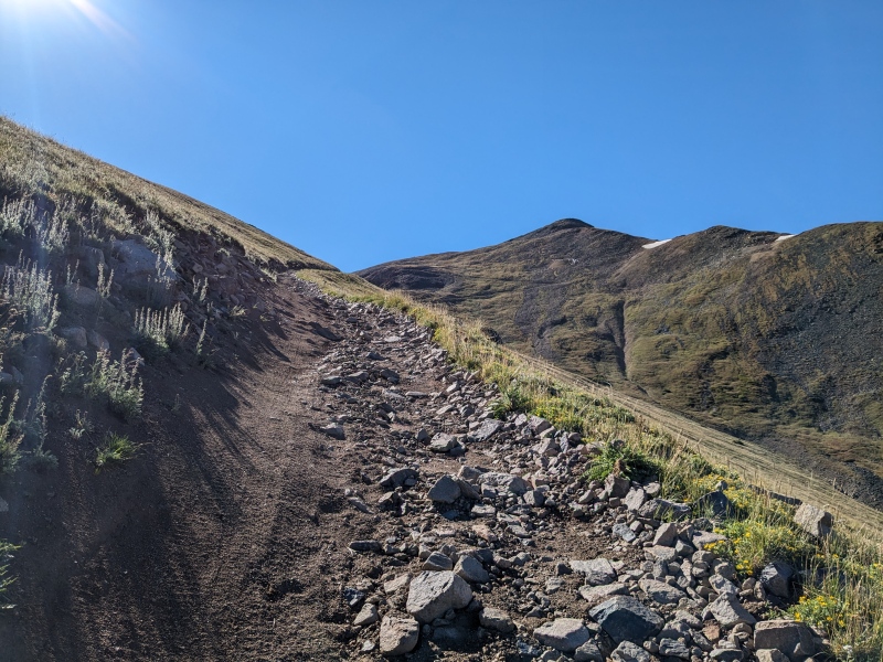
Phase I - The Switchbacks: To get from Montezuma to Santa Fe Peak, I followed a 4WD road that immediately starts switchback'ing up the side of the ridge. The road is decent quality, so I was able to get up to Santa Fe quickly. Once near the top, the road skirts around the actual summit of Santa Fe, so I had to jump off and ascend the final 50 ft. or so off of the road.
Just above the treeline on the road, looking at Santa Fe.The final approach to Santa Fe. Road is still good quality.
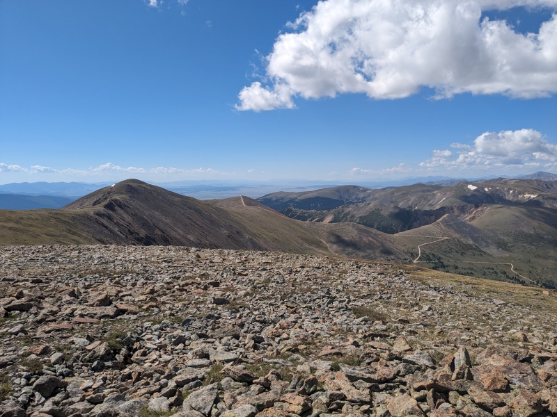
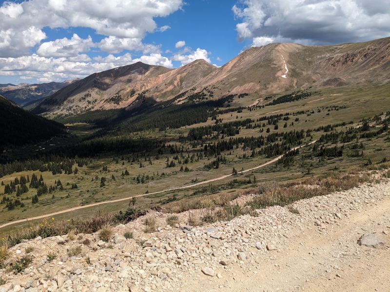
Phase II - The Ridge: Once on top of Santa Fe, all the remaining 13ers, as well as Webster Pass, are all visible. It became apparent that the "crux" (only class 2, so not that hard) was going to be the ascent up Geneva Peak.
View from the top of Santa Fe. Next up is Sullivan, then Geneva (looks worse than it really is), then Landslide down to Webster Pass.
Going down the other side of Santa Fe, the 4WD road continues for a bit before making a sharp turn to the right. This goes down to an abandoned mine halfway down the mountain or something, so I turned off the road as soon as I realized it was no longer heading the direction I wanted to go -- towards Sullivan.
Sullivan is a pretty uneventful summit, just another peak to bag in the loop.
Summit of Sullivan. Geneva looks intimidating, but it never is more than Class 2.
After Sullivan comes Geneva Peak. I thought this was going to be much more difficult than it was. In actuality, it was just a low Class 2 climb, with the route easily bypassing what, from the peak of Sullivan, looked to be a possibly gnarly traverse from the false summit to the true summit.
Once on top of Geneva, it became the apparent the the hard part was over. The other side of it was comparably tame compared to the climb up. The only thing to note is that Landslide appeared to be very out-of-the-way on the left, with Webster Pass on the right. There was another, unnamed peak on the more obvious ridgeline. I've looked it up since and still haven't found a name for it anywhere. This was somewhat surprising because, by comparison, Landslide Peak is a very flat, unimpressive summit, while this unnamed 13er point at least had some prominence
On top of Geneva, looking at Webster Pass and the unnamed 13er point. Landslide is out of the frame, further to the left.At the "summit" of Landslide Peak. I was not very impressed with it. Bierstadt and Evans in the background.
Phase 3 - Webster Pass and the Long Road Back: From Landslide Peak I went over to the unnamed 13er point. From here, there's a trail that goes down and joins the 4WD road in between Red Cone and Webster Pass. I turned right on the 4WD road to head to Webster Pass.
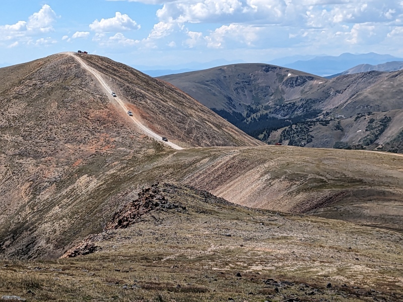
Looking at the Jeeps coming down Red ConeOn the 4WD road just below Webster Pass looking at the 13ers on the ridgeline. Santa Fe is the one in the shadow on the left, followed by Sullivan and Geneva going right.
From the top of Webster Pass, it's about 5 miles on the 4WD road back to Montezuma. Needless to say, if you do this in August like me, you'll be sharing the road with a fair amount of Jeeps/4-Wheelers/Dirt Bikes/Side-by-Sides. I decided to jog once I was on the road, and was going about as fast as the Jeeps, but was still being passed by the smaller nuisances. I do have to give a shout-out to one Jeeper, who let me hop on his back bumper to cross a creek that was probably a good foot-and-a-half deep about halfway down the 4WD road.
Conclusion: All-in-all, this was a fun route to bag 4 13ers in quick succession. Given the amount of time on 4WD roads, it can be done pretty quickly. I did it in four and a half hours, but that was jogging all the way down. Let me know in the comments if you have any other questions!
Link to Strava if you want to see any details: https://www.strava.com/activities/9680972825
My GPS Tracks on Google Maps (made from a .GPX file upload):
I had the pleasure of doing those from Geneva Basin awhile back and did them in the opposite direction. All in all, it was still a blast! It would have been nice to have used a road to get up there, but the bushwhack wasn't too bad and the descent off Santa Fe went well. A couple years ago, I did a tour of Webster Pass hitting Teller, Handcart and Redcone via those roads out of Deer Creek across the Divide and up the Redcone Road. I enjoyed watching those crazies drive their jeeps down that sick drop. Although I didn't jog back, I do remember that creek crossing on the way back. I somehow managed to find a logjam bridge and get across without taking a cold bath. I ate a lot of dust from all the road traffic. Maybe a fall in the creek would have been a good thing? I met a guy on the pass who rode his bike from Dillon. It's not that bad a road to ride up. Now that's something I would like to do and ride up Santa Fe too. On the other handhand, I wouldn't mind slapping around a couple dogs in Montezuma that gave me some s**t! Otherwise it was a fun loop.
Haha, funny that you mentioned all the dogs in Montezuma - there certainly are quite a few! Sounds like a fun route doing the other side like you were mentioning, might have to go back to hit those.
Caution: The information contained in this report may not be accurate and should not be the only resource used in preparation for your climb. Failure to have the necessary experience, physical conditioning, supplies or equipment can result in injury or death. 14ers.com and the author(s) of this report provide no warranties, either express or implied, that the information provided is accurate or reliable. By using the information provided, you agree to indemnify and hold harmless 14ers.com and the report author(s) with respect to any claims and demands against them, including any attorney fees and expenses. Please read the 14ers.com Safety and Disclaimer pages for more information.
Please respect private property: 14ers.com supports the rights of private landowners to determine how and by whom their land will be used. In Colorado, it is your responsibility to determine if land is private and to obtain the appropriate permission before entering the property.


")
")
")
")
")
")
")
")
")