| Report Type | Full |
| Peak(s) |
Mount Shuksan 9,131' |
| Date Posted | 08/05/2023 |
| Date Climbed | 07/27/2023 |
| Author | Wimyers |
| Fisher Chimneys |
|---|
|
On 7/27, I climbed Mount Shuksan in the North Cascades with my wife, Ana, as a team of two. When the weather for our primary objective in Wyoming turned for the worse, we switched gears last-minute to climb Mount Shuksan, and we only had a little time to find beta. The info we found was pretty ambiguous, and focused on the rock sections without discussing the glacier portions much. It was our opinion that the beta we found was targeted towards climbers who had less rock experience and more glacier experience than we did. Because glacier travel was our relative weakness, we felt a little anxious about what we would find up there. Since there are no Fisher Chimneys trip reports on this site, I wanted to create this report for Colorado climbers who, like us, have lots of rock experience, but limited glacier experience. This report also contains some lessons learned from our trip. First, it's probably a good idea to look at the route on Google Earth. I already had a track on my GPS device from Alpine Savvy (attached to this report), but didn't have a chance to view it on a computer. The route is really tortuous, even a bit convoluted, and I honestly had no idea where I was going on a macro-scale for most of this climb. Looking up from Lake Ann, I was pretty clueless where I was headed. The pic below shows the route from Lake Ann. 
Secondly, we camped at the top of Winnie's Slide, shown in blue in the image above. In hindsight, I think it's better to camp at Lake Ann unless you're good at ultralight camping. Hauling our heavy packs up the 4th class chimneys really sucked, and was pretty slow-going. Sure, climbing the chimneys in the pre-dawn dark is less than optimal, but we would have gone so much faster and had more fun with lighter day packs here. If I do this route again, I will camp at the lake. Thirdly, here is the gear we brought:
We drove in from Denver and arrived at the ranger station around 11am to obtain a walk-up permit to camp at Winnie's (the fact that permits were available probably speaks to the fact that no one wants to haul camp up the Chimneys). We started hiking at 1pm. After a 4.5-mile hike on good trail, we reached the lake at about 3pm. From here, the trail becomes more rugged as you climb towards the first bluff. We crossed a snow moat and scrambled up a 3rd-class gully to find another rugged trail that climbed the knoll and across a scree slope. 
It was 4:45pm when we crossed the scree slope. This is where the route finding becomes more difficult. 
Locate the deep notch, shown above, on the opposite side of the scree slope. Climb the notch, which is 4th class and a bit awkward with a heavy pack. 

Another climber's trail is visible from the top of this notch. 
The trail is easy to follow. It drops a little elevation as it winds around the cliff band. 
From the point in the photo above, the crux of the chimneys is visible; a ramp with a notch. 
I saw some beta that called this bit low-5th, but I thought 4th was about right. It's exposed, but there are very positive hand and footholds, and the rock is very good. However, with her heavy pack, Ana was less comfortable and opted to ascend with a hand line, which I supported from above. 
At the top of the ramp, there is more good trail. 
The scrambling from here is more straight-forward, but still 4th class. The rock is mostly good, but this next section does present a rockfall hazard from loose stones in the gullies. 
After another 1,000' or so of 3rd/4th scrambling up a gully, we finally topped out at the start of the glacier, shown below. It was now 6pm; we had taken about an hour longer than I anticipated. 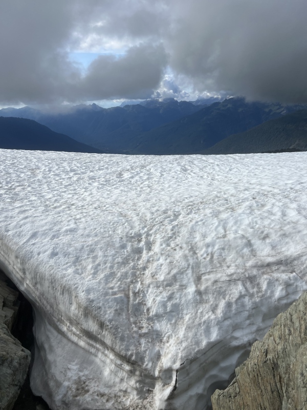
Ana was tired and didn't want to haul the heavy packs any further. However, there was no running water at the lower bivvy sites, so we opted to climb Winnie's slide to gain the upper bivvy. Winnie's slide is a steep section of glacier that was the crux of the route for us. 

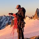
I changed from my approach shoes into my mountaineering boots and roped in. I used my axe and my tool for this section, but the tool wasn't really necessary because the glacier was covered in good snow, and there was a solid boot pack. I don't think I would have been comfortable climbing the late season exposed glacial ice, though, even with the tool and screws. Once above, I placed a picket and belayed Ana up to me, who climbed with just an axe. There were great tent sites and a source of running water above Winnie's. There was only one other party camping on the route. 
It was 7pm when we finally pitched the tent. We quickly ate, filtered water, set up the rope for glacier travel, and went to bed. Our wake-up call was at 4:15, and we were leaving camp at 4:45. 
The glacier travel starts right away. A precarious boot pack heads up the hanging glacier and onto the Curtis glacier. This was the most broken up of the glaciers we navigated, but the route finding was easy enough. There were a couple crevasse step-overs and some exposed glacier ice here. I can see how this section would be very challenging in late season. Once on the Curtis glacier, the route was easy going. 

Hell's highway was the next considerable obstacle, pictured below. It was another steep pitch of snow- this one a bit less exposed than Winnie's. Again, the snow was good and there was a solid bootpack. I soloed up and hip belayed Ana. This time, my extra tool stayed stowed. 
Now on the Sulfide route, it was easy snow to the summit pyramid. We were going for the alternate 5.3 SE ridge route, depicted with red dots in the photo below. The standard route, depicted with green dots, ascends gullies on the face and goes at 4th class. When we got to the pyramid, we stashed our boots and crampons and changed into approach shoes (Thankfully we kept our axes; the descent route took us to a different spot and we had to climb the snow in approach shoes, which was sketchy even with axes). 

A guided party that had ascended the Sulfide route was first to the summit pyramid and started climbing the ridge at the red circle in the photo above. I passed them using the route indicated by the blue dots. There seems to be many ways to gain the 5.3 SE ridge; my way was pretty dirty, but it got us on the ridge.The ridge certainly seems to be the recommended ascent route; all four parties climbing Shuksan that day ascended the 5.3 ridge over the standard 4th class gully. To climb the ridge, we doubled over our half rope and simul climbed with about 15 meters out (and the rest coiled). The summit ridge was definitely the most fun part of the day. The rock was excellent and featured, and the route finding very obvious. The exposure was good, but not frightening. We found the terrain quite conducive to simul climbing and short-pitching; it was almost all 4th/low 5th, with about (3) 5.3 bumps. I brought a light rack of (4) cams and a set of nuts, but ended up soloing the entire ridge on lead anyway. After each hard section, there was a flatter section I could use to terrain belay Ana for the cruxy bits. I did place one cam (#1), which I used as a 1-piece anchor to belay with. 
The beta on the ridge varies wildly- some folks were even calling it 5.6/5.7, and saying it took them 3 hours to climb it! It took Ana and I 50 minutes, and I would call it 5.2 if comparing to flatiron scrambling. 
We reached the summit at about 7:30am, about 3 hours after leaving camp. We down climbed the 4th class standard route. There was tat everywhere. We could have rappelled the entire gully if inclined to, but instead skipped every rappel. The terrain was easy, and it was faster to just down climb. Once at the base of the pyramid, we did a quick snow climb/traverse to get back to our boots and crampons. While putting our boots back on, we met another group that was transitioning to climb the ridge. They were locals with lots of glacier experience, but limited rock experience, and they were going to pitch the whole ridge out with a full double rack. We discussed how they thought the rock section was definitely the crux of the route, and that I thought Winnie's was the headiest part for me. Later that day, I met another party that said the 4th class approach chimneys was the crux for them. I think an interesting facet of this route is that all three distinct sections are probably equally difficult, but each party may think a certain section is their personal crux depending on their experiences. 

On the way back down, with Ana leading the way down Hell's highway in the mid-morning heat, I had an unexpected fall when one of the previously solid kicked steps on Hell's, now softened in the sun, slid out under my weight. I was facing out from the slope, and was unable to prevent my slip from becoming a slide. Fortunately, I was able to self-arrest my slide in the good snow before gaining too much velocity. Still a bit scary, though! We probably should have gone one at a time a placed our pickets here, and this slide impacted my risk tolerance for Winnie's later in the day. 
The route on the way back was breaking up even more in the heat; I think we were at the tail-end of the season for this route (this year). I post-holed into a crevasse trying to step over it, but otherwise the way back was uneventful. Some of the icy bits were scary, though. It was 11am when we got back to our tent, for a 6-hour camp to camp trip. We took a nice break a started back down the long chimneys section. around noon. Descending Winnie's was next. After the slide on Hell's, I wasn't keen to solo it again. I placed a picket at the top of the slope and did a belayed down climb to a shelf about a fourth of the way down, and clipped into a piton anchor here. I put Ana on belay, and she down climbed to me. Then, I lowered her on a redirected ATC until she reached a point where the steepness mellowed. It was about 40 meters down, and my rope was only 60 meters. I rappelled on a single-strand by using a Reepschnur block, and improvised a tagline using all my tat and slings so I could pull the rope from Ana's stance. This worked well, was very safe, and I left no gear. However, it took kind of a long time, and maybe I should have just down led this section using our two pickets. We started our way down the chimneys. Now with a heavy pack, Ana wanted to opt to rappel the cruxes of the chimneys using the abundant amount of tat. We did maybe 4 rappels here, and made it back to the lake at around 4pm. We spent one more night at the lake and finished the hike out early the next morning. I think this was my favorite climb I have done in the PNW! The glaciers were wild- I had never been on glaciers that broken up and interesting before, and it was cool to touch four different glaciers in one climb (white salmon, hanging, curtis, and sulfide). The ridge was also a real treat. And the mountain as a whole is incredibly aesthetic! 
Thumbnails for uploaded photos (click to open slideshow): ")
")
")
")
")
")
")
")
")
")
")
")
")
")
")
")
")
")
")
")
")
")
")
")
")
")
")
")
")
")
|
| Comments or Questions | ||||||||||||
|---|---|---|---|---|---|---|---|---|---|---|---|---|
|
Caution: The information contained in this report may not be accurate and should not be the only resource used in preparation for your climb. Failure to have the necessary experience, physical conditioning, supplies or equipment can result in injury or death. 14ers.com and the author(s) of this report provide no warranties, either express or implied, that the information provided is accurate or reliable. By using the information provided, you agree to indemnify and hold harmless 14ers.com and the report author(s) with respect to any claims and demands against them, including any attorney fees and expenses. Please read the 14ers.com Safety and Disclaimer pages for more information.
Please respect private property: 14ers.com supports the rights of private landowners to determine how and by whom their land will be used. In Colorado, it is your responsibility to determine if land is private and to obtain the appropriate permission before entering the property.