Download Agreement, Release, and Acknowledgement of Risk:
You (the person requesting this file download) fully understand mountain climbing ("Activity") involves risks and dangers of serious bodily injury, including permanent disability, paralysis, and death ("Risks") and you fully accept and assume all such risks and all responsibility for losses, costs, and damages you incur as a result of your participation in this Activity.
You acknowledge that information in the file you have chosen to download may not be accurate and may contain errors. You agree to assume all risks when using this information and agree to release and discharge 14ers.com, 14ers Inc. and the author(s) of such information (collectively, the "Released Parties").
You hereby discharge the Released Parties from all damages, actions, claims and liabilities of any nature, specifically including, but not limited to, damages, actions, claims and liabilities arising from or related to the negligence of the Released Parties. You further agree to indemnify, hold harmless and defend 14ers.com, 14ers Inc. and each of the other Released Parties from and against any loss, damage, liability and expense, including costs and attorney fees, incurred by 14ers.com, 14ers Inc. or any of the other Released Parties as a result of you using information provided on the 14ers.com or 14ers Inc. websites.
You have read this agreement, fully understand its terms and intend it to be a complete and unconditional release of all liability to the greatest extent allowed by law and agree that if any portion of this agreement is held to be invalid the balance, notwithstanding, shall continue in full force and effect.
By clicking "OK" you agree to these terms. If you DO NOT agree, click "Cancel"...
As we start getting further into spring, I've started fantasizing about my new favorite way to approach 14ers... with a paraglider. This has me recounting and reliving a wonderful experience I had last October on Grays Peak, which I thought I'd share with you all.
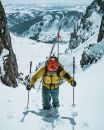
My view at the top of Greys, contemplating the number of things that could go wrong
I started paragliding in summer of 2021. My fiancé was out of town for a couple months, so there was no one around to talk me out of taking lessons. I learned from Red Tail Paragliding in Boulder. And after a few months of lessons, I was a certified P2 pilot. Most peoples' approach to paragliding is to maximize the flying to hiking ratio, trying to take off from fairly short hills and thermal up to cloudbase and see how far/long you can fly. I quickly realized that I really didn't mind the hike, and I really enjoyed the 'sledders' back down. I decided that as long as I'm interested in climbing peaks, I might as well try to float down instead of hike. This also adds to my continual effort to avoid downhill hiking; I have the skiing on lock, done some mountainbiking, but the paraglider doesn't seem as dependent on snow or trail difficulty.
Awaiting Conditions:
Like skiing, I've found that flying off peaks really takes the right conditions. Unlike skiing though, these conditions seem to be pretty fleeting. This is Colorado after all, we have a lot of wind and it's typically very gusty on the peaks. So, I watch the forecasts, and wait for the right conditions to eventually line up with a morning that I'm free. I tried earlier in the summer to fly off Grays and found that I got there a little too late in the morning, gentle winds had turned to gusts. So, I knew that I would need to get there earlier, and would just have to wait for another chance. Finally, the stars seemed to align, on a Saturday too! The HRRR was snowing 5 knot winds from the NE until about 10AM when they increased to just 10 and switched west. If that's correct, it would be ideal for an early morning flight.
The Coldest Hike of Grays Ever:
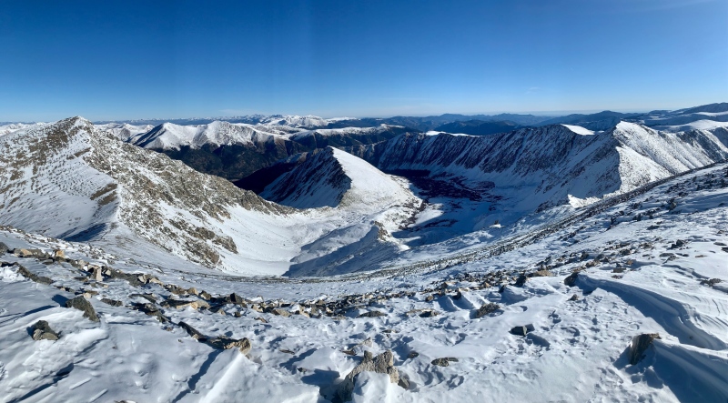
I got started from the summer trailhead at 6:30AM and hurried along, up the trail. It's late enough in October that the trail is snow-covered from the parking lot. I made pretty good time, making it to the summit in just about 2 hours. I was doing my best to keep moving through tons of post-holing on the upper mountain and the bitter cold. I might have taken more photos, but my phone kept dying every time it was out of my pocket for more than 5 seconds. However, I made it to the summit, warmed by the rising sun and elated to find that the conditions were just as good as forecasted, dead still.
Takeoff:
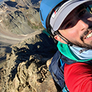
I hung out on the summit just long enough to get my breath back, and then started looking for a good launch spot. There was a great area, right off the summit, to the NE. I got my wing out, got my helmet and and harness on, and stood there taking in a deep breath and the view. I reminded myself that the wing goes a little faster at altitude, meaning that you have to run faster for the takeoff too. Conditions still felt great, and I leaned forward a tad diving the lines a bit of a tug, as if just testing how things were feeling. However the wing picked right up, and I thought, "shit, better get my feet moving". As I expected, the running was quite committing at that speed. There wasn't really an option to slow down, or even stop, once I had started. But, in just a couple seconds, I was off the ground, skimming down the face. I skipped off one final rock and was off. There was huge relief once I was in the air. I was so glad that I wasn't going to need to deal with all that post-holing to get back down. After another moment, I realized there's still a decent number of things that could go wrong.
However, everything went great. I got to check out the east face of Torreys from a new perspective and then did my best to fly as close to the trailhead as the glider would take me.
I spied a great spot, just north of the trail, and above the sea of willows that surrounds the first mile of the trail. Often times, there's "valley suck" as the sun comes up in the morning, which pulls air down valleys as the lower elevations heat up. So, expecting this, I made a quick 180, right into the middle of the field and stuck the landing.
After that, I had a fantastic, short hike out to think about how great that morning was.
Thanks for reading!
My GPS Tracks on Google Maps (made from a .GPX file upload):
Flying off the top for the quick way down. Wow, that must have been some thrilling experience. I've been hiking in Palmer Lake for more than a decade and some like to paraglide and launch themselves off the summit of Mt Herman. I saw a paraglider for the 1st time on Tuesday while I was descending Chautauqua Mountain. A sign up there warns of a possibility of approaching aircraft from the AFA. So you have to be on the lookout before committing . Also a windsock at the summit helps with determining the favorable winds. A good landing pad is at the TH on Red Rock Ranch Rd and Mt Herman Rd. You should check this place out. Quick easy drive down I-25 from Denver with good access to the TH there. A good place to get multiple flights if you were so inclined to do so. It's only about 1,800' to the top.
That's a pretty popular site, and it's organized by RMHPA, more info here. It looks sweet because it's quite a bit more vert than most of the front range sites. I've been meaning to make it down there, but I just haven't yet since I'm in Boulder.
Caution: The information contained in this report may not be accurate and should not be the only resource used in preparation for your climb. Failure to have the necessary experience, physical conditioning, supplies or equipment can result in injury or death. 14ers.com and the author(s) of this report provide no warranties, either express or implied, that the information provided is accurate or reliable. By using the information provided, you agree to indemnify and hold harmless 14ers.com and the report author(s) with respect to any claims and demands against them, including any attorney fees and expenses. Please read the 14ers.com Safety and Disclaimer pages for more information.
Please respect private property: 14ers.com supports the rights of private landowners to determine how and by whom their land will be used. In Colorado, it is your responsibility to determine if land is private and to obtain the appropriate permission before entering the property.
")
")
")
")
")
")
")
")