| Report Type | Full |
| Peak(s) |
Breithorn (13,665') Gornergrat (10,285') Monte Rosa Hut (9,459') Platthorn (10,908') Mettelhorn (11,122') Grindelwald Aellfluh (4,658') Klein Matterhorn (12,739') Suggiture (6,889') Augstmatthorn (7,011') Harder Kulm (4,334') |
| Date Posted | 08/28/2022 |
| Modified | 11/08/2022 |
| Date Climbed | 08/01/2022 |
| Author | jfm3 |
| Swiss Alps Training Camp |
|---|
|
The last 2 years I haven't done any international travel because of the pandemic. With virus-related restrictions finally easing this spring, I figured it was time to return to world-class mountains. I am (hopefully!) going to finish the 14ers this year and I'm transitioning into taller, harder and longer mountain objectives. My original plan was to go back to Banff National Park in Canada. I had a great time there in 2019 and there were plenty of remaining mountains and running routes to complete. That trip had some lingering disappointment, as I was snowed/buzzed off Mt. Temple just 500' from the top. I thought I would use a return trip to finally summit Mt. Temple, and explore more of the Lake Louise & Jasper area. On my previous trip, I drove my own car, stopping in my home state of Wyoming and Glacier National Park in Montana along the way. This time, I would fly Denver <-> Calgary and rent a car for the short drive to Banff. However, when I started planning, I couldn't believe the prices. The flight was cheap ($300) but rental cars started at $220/day, not including gas, and hotel rooms in Canmore started at $200/night. Even a 5-6 day trip would be exorbitantly expensive. 3 grand to not even leave the mountain time zone? No thanks. I thought about where else I could go. I have been slowly accumulating the skills, fitness and confidence for a massive trip to Chamonix, but that trip is still a year off. If not Chamonix, where else in the Alps could I go? I went to Switzerland for a 2-week tour in 2018, stopping in Davos, Wengen and Zermatt. I remembered that Zermatt had a lot of high-mountain routes above the trails in the foothills. I barely brushed these routes with a run from town up to the Hornli Hut on Matterhorn, but there seemed to be a lot of terrain and cool things to see. I read my old training log entries, looked at the map and in about an hour I decided to go back to Switzerland for a week. Because I already went to Switzerland, I was familiar with some of the travel logistics. The links below were useful for both trips. These have a wealth of information about routes, conditions, lodging/dining and transportation, as well as spectacular webcams that run all day, every day. https://www.jungfrau.ch/en-gb/ https://elevation.alpsinsight.com/ https://www.meteoswiss.admin.ch/home.html?tab=overview https://www.sbb.ch/en/home.html I flew from Denver to Chicago (United) to Zurich (Swiss Air). Edelweiss Air is again(?) providing direct Denver <-> Zurich service (https://www.flyedelweiss.com/EN/fly/flight-information/timetable/Pages/denver.aspx) but this wasn't available when I was buying tickets in May. From Zurich, I took the trains to Zermatt. The 1.5 days of travel to get there were about as easy as possible. Both flights were on time, my suitcase made it to Zurich, the security lines were short and Switzerland didn't have any virus restrictions so there was no worry about being admitted into the country. The meals on the overnight flight were alright and I got a few hours of sleep. I stayed at the Hotel Basecamp in Zermatt (http://www.hotel-basecamp.ch/), the same place I stayed in 2018. 
After eating and unpacking in Zermatt, I went for a short run on a trail north of town. I didn't feel great but it was good to get out and move. Legs felt fine but I was tired. The trail was steep with great views of Breithorn and the Gornergrat climb. I took a long break at a small ledge above some rock nets. 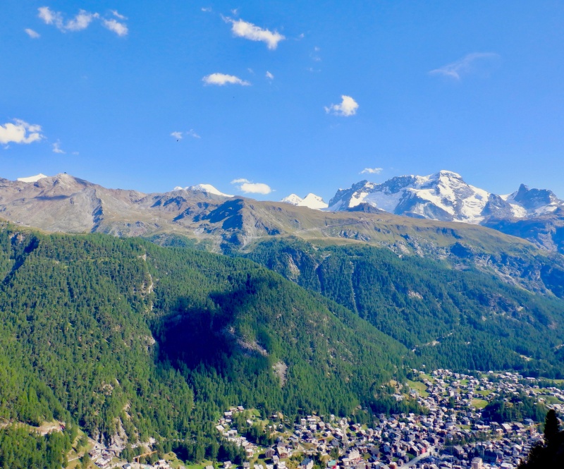
I made a grocery run at the Coop store on the way back to the hotel. A final look at the route and the weather forecast and it was off to sleep. After 3 trips to Europe, I've found the best way to adjust to the time difference on the first day is to sleep (or try to sleep) on the overnight flight, then stay awake the whole first day. The afternoon and evening are tiring, but a good sleep the first night on the ground usually sets me up for the rest of the trip. Strava entry for Zermatt run: https://www.strava.com/activities/7560911044. The first big outing of the trip was a mountain run up & down Platthorn and Mettelhorn, two peaks just to the west of Zermatt. Both summits were visible from my hotel room, almost 6,000 feet directly overhead. I followed the route described by the AlpsInsight guide: https://elevation.alpsinsight.com/switzerland/mettelhorn/. I had a small breakfast at the hotel, then geared up and set off while Zermatt was still in shadow. The route went up a few alleys and by a few farm sheds before I was above all the buildings. I put on sunscreen shortly before leaving the trees and starting the real ascent. 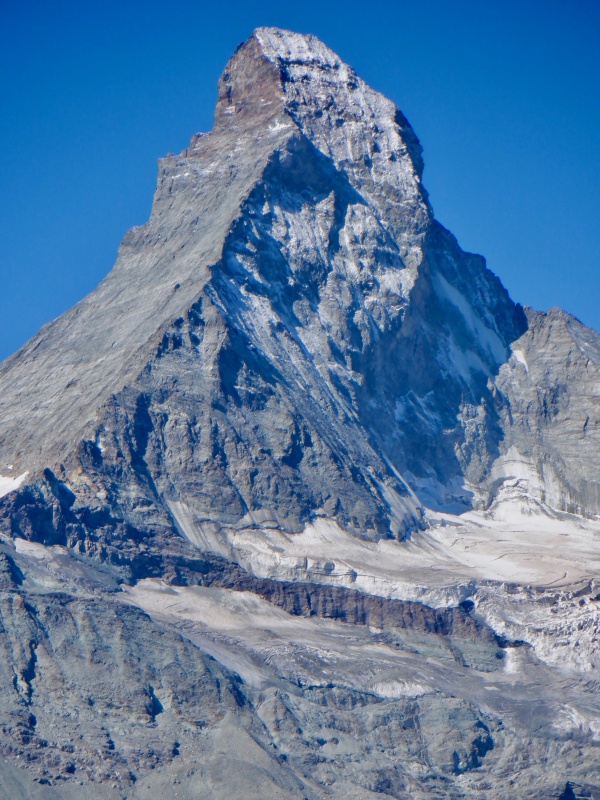
The first climb to the Matterhorn panorama was 3000’ in about 2 miles. It was really steep. Reminded me of the big slope on Maroon Peak. I could only see a few switchbacks up the hill. Two people were visible high above. A few paragliders drifted by. There were no clouds and the scenery to the east & south slowly opened up as I slowly inched up the slope. I couldn’t see Matterhorn until the very top of the climb. No wind, full sun and the ridiculously steep grade made for a lot of sweat. I took a break to cool off & recover at the top of the climb, sitting on a bench to gaze at the glaciated peaks to the southeast. 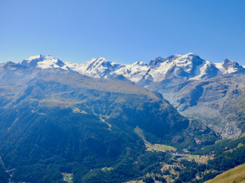
The descent to Trift went quickly. I ran at an easy pace, watching Platthorn & Mettelhorn come into view. Quite a few people were on the trail going the other direction. I stopped at Trift to refill water from the Rothorn Glacier runoff. The Rothorn Hut was visible high above, almost the same color as the rock surrounding it. 
The next 2700’ climb to Furggji Pass wasn’t quite as steep. The trail wound tightly up a grass bluff before flattening out for a few steps. A slight breeze made the exertion easier. I was slowly gaining on a large group a few hundred feet above me. As I reached the final slope, a cacophony of rockfall sounded way over to the right, below a series of large slabs. I looked up to see a small herd of ibex running across the slope, knocking down all kinds of junk. I caught the large group a few minutes below the pass. Both summits were visible as I sat on the pass, with Weisshorn towering behind. 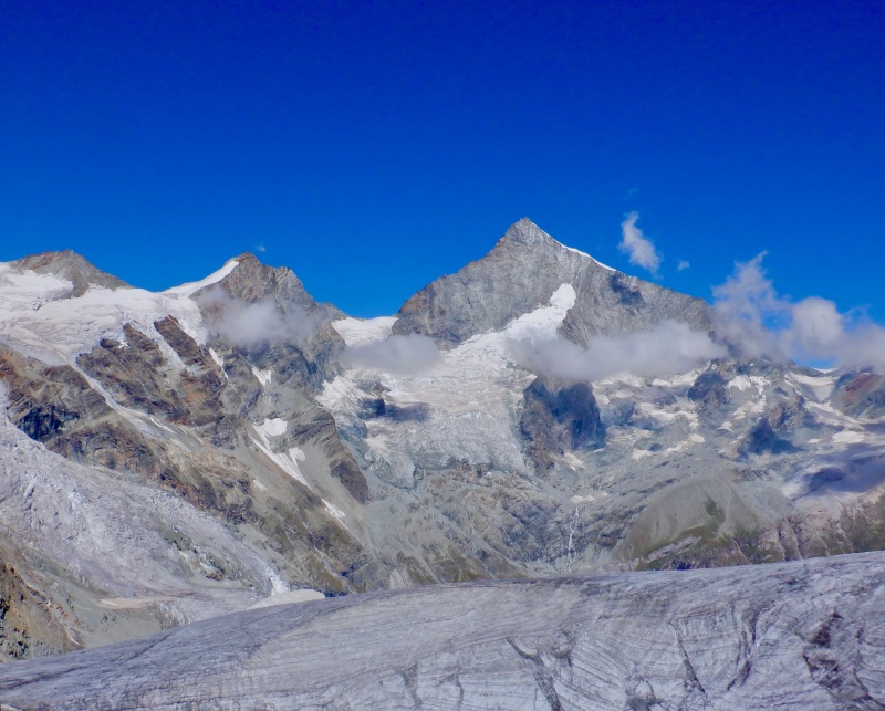
The final 500’ climb up Platthorn was the steepest of the day. No real switchbacks, just straight up the talus. The views from the top were astounding. A full 360-degree panorama of enormous vertical relief, glaciers, pointy summits and endless ridges of mountains. I took a lot of photos and looked at everything through the binoculars. 
More awaited on Mettelhorn, so I ran back to the pass. I put on crampons and used the short ice axe for the glacier crossing. It was only a few minutes, but I wanted to use the snow gear after lugging it all the way up. A few people I passed didn’t have foot traction and were sliding around. Mettelhorn had good switchbacks so the final climb was fast. I took another long break, taking in the scenery from the exposed perch and fueling for the descent. 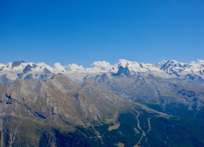
It didn’t take too long to descend Mettelhorn and cross the glacier to the pass. I’m getting faster with crampon transitions. From the pass, it was just 90 minutes of relaxed running to descend 5000’ back to town. It goes quickly on such steep terrain. My legs felt good as I dropped to Trift, with Breithorn & Matterhorn filling the sky. I cooled off in the creek at Trift, then weaved around hundreds of people on the steep canyon descent. 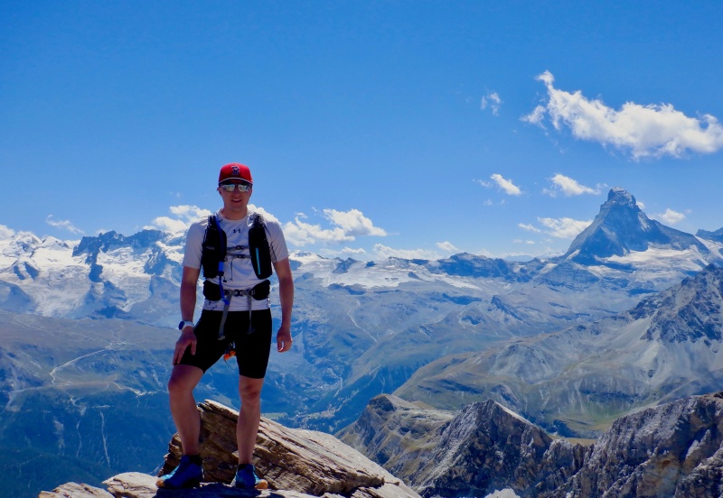
I walked the last few streets to the hotel. Everywhere was busy with buffets and entertainment for the Swiss National Day. Strava entry for Platthorn + Mettelhorn: https://www.strava.com/activities/7566180193. 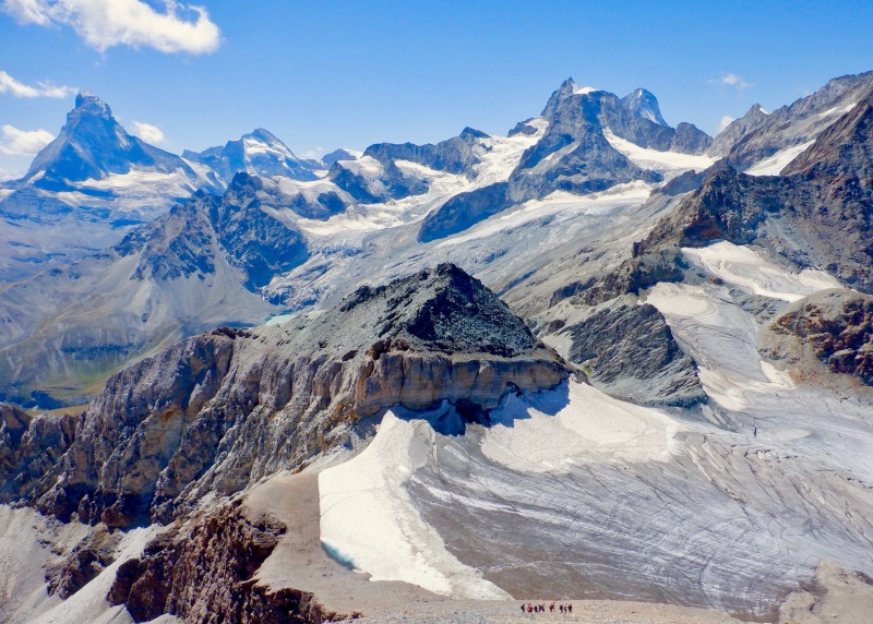
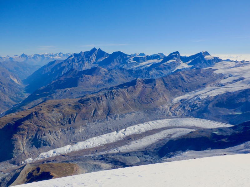
The next day I completed a huge loop from Zermatt up to the Monte Rosa Hut, over to Gornergrat and back down to Zermatt. The Monte Rosa Hut is used as the overnight stop on a climb of Dufourspitze, the highest mountain in Switzerland: https://monterosahuette.ch/?lang=en. The route had some of everything: a vertical mile each of uninterrupted ascent & descent, huge peaks, sustained crampon use, 2 glacier crossings and almost 12 hours on my feet. It was one of the hardest and most spectacular mountain days I've ever done. 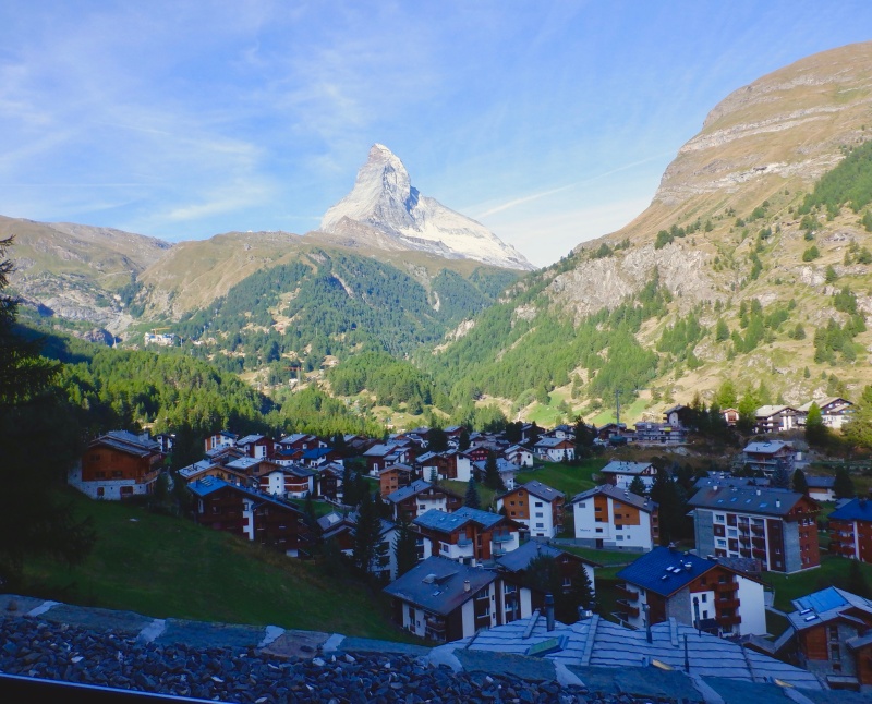
I again started out the front door of the hotel. I had some navigational problems in all the steep, narrow alleways. I had to walk next to the Gornergrat railway for awhile, then I started uphill too early. I realized my error after a few minutes and got on the correct trail without wasting too much time. Sometimes it’s hard to tell what’s actually a real trail on the Strava map when I make the GPS route. The climb to Riffelalp was a slog. I could occasionally see north to Platthorn & Mettelhorn but the view was mostly trees. The switchbacks dragged on, gaining elevation but seemly not getting any closer to the treeline. I saw an alpine goat grazing in a small clearing. 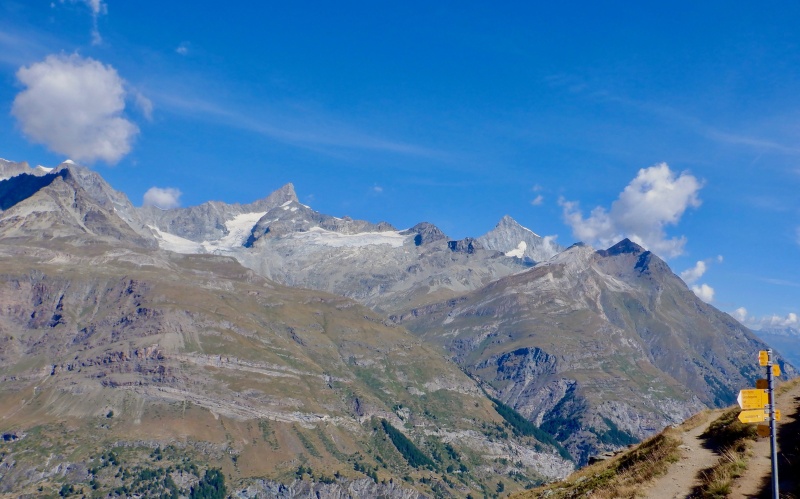
The trail suddenly flattened out and led to the yard in front of the Riffelalp hotel, underneath the huge view to Matterhorn. I took a short break, then started up the steep slope below Riffelberg. The terrain fell away quickly, giving great views to the south and west. As I came around the corner the huge north side of Breithorn came into view. The mountain looked close but the top is over a vertical mile above. 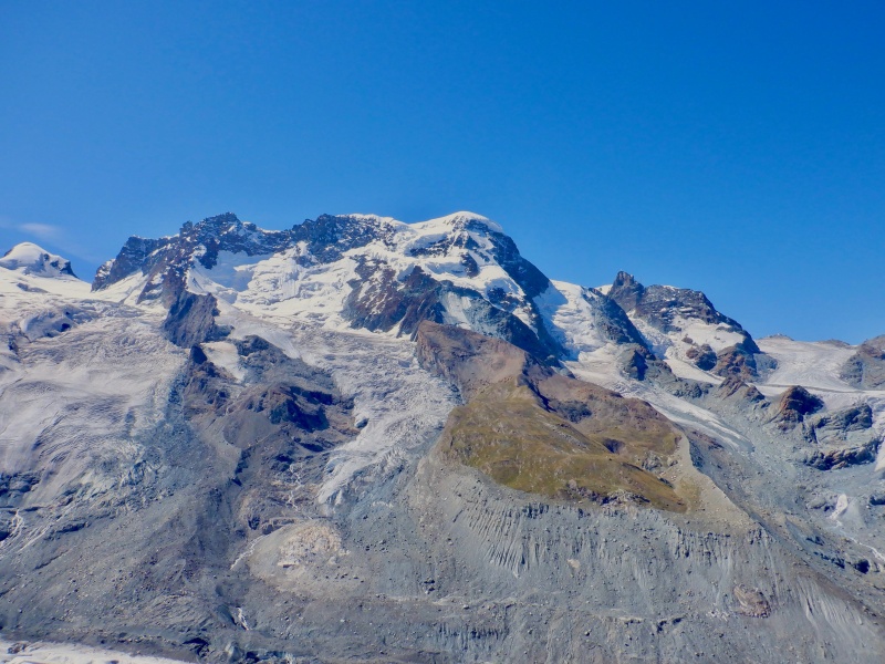
More people, probably walking down from Gornergrat, appeared as I hiked up to Riffelhorn. Lyskamm, Castor, Pollux & Dufourspitze towered above the Gorner Glacier moraine. I could see the Monte Rosa Hut, glinting slightly way up the glacier. The trail descended onto the south side of Gornergrat but didn’t drop as quickly as I expected. I ran steadily east toward the glacier. The Hohtalli split rose upward at a punishing angle. That should be fun in 4 hours. The trail eventually reached the moraine at the Gorner Glacier entrance. 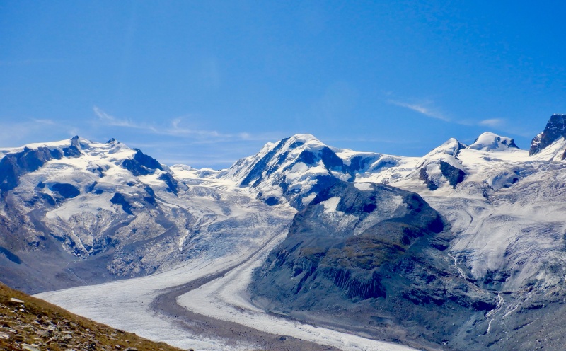
I took a break to put on the crampons, ice axe and some layers. The ever-present cloud clung to the side of Matterhorn. The glaciers on the high peaks hung far above, providing an awesome backdrop. I stared up the glacier behind 2 other groups. A series of 6-foot plastic poles marked the route. My crampons crunched nicely into the ice. The initial climb was in benign terrain, with only a few small crevasses that were easy to step over. Meltwater flowed on both the surface and underneath the ice. I passed both groups in front of me and soon reached the “top” of the route. 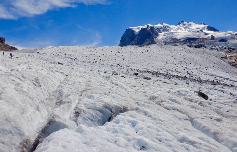
The poles hung a hard right, immediately entering more complicated ice. The crevasses grew larger and the surface more uneven. A few of the crevasses were deep enough to fall into. I carefully walked along, occasionally using the ice axe for support. The route descended slightly, crossing a few more crevasses before exiting onto the moraine. I took off the crampons and started toward the hut. It looked close. 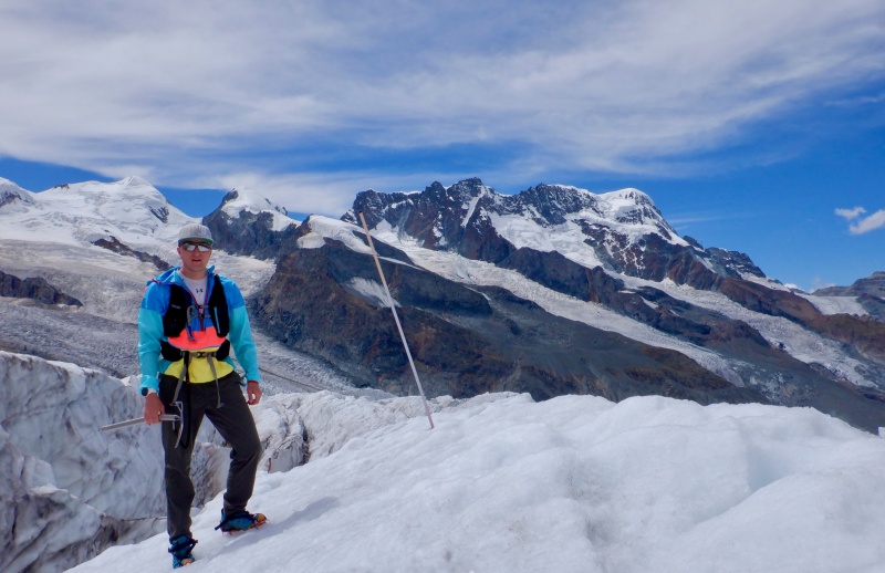
It was not. It took almost an hour to grind through the 1.5 miles of awful moraine to the hut. There were some trail segments, but it was mostly endless up & down movement over boulders, gravel, slabs, waterfalls & silt. Progress was slow and the hut never seemed to get any closer. I existed from one blue-white marker to the next. Once I crossed the last of the streams there were a few fixed lines up some slabs & large steps. I arrived at the hut feeling fine physically, but somewhat daunted by all the vert & mileage still remaining. 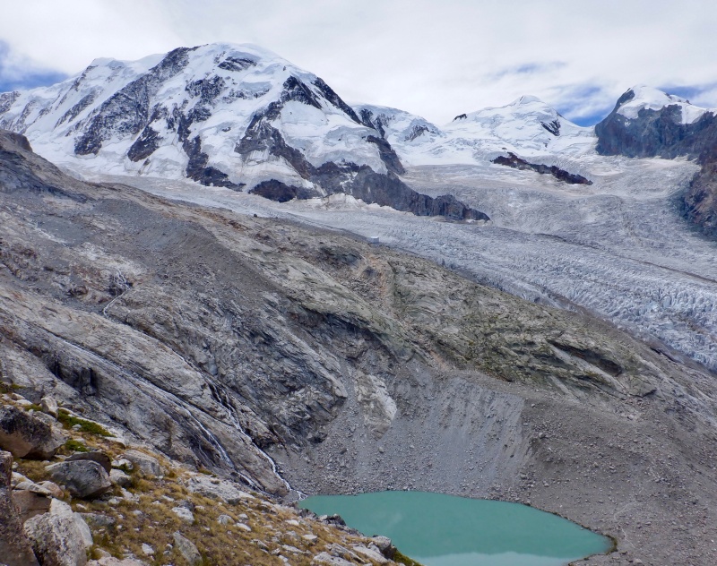
I took a long break at the hut. Several other people were on the deck, organizing/packing/drying mountaineering gear. The scenery was spectacular. Glaciers, huge mountains and perfect weather. I looked at the remaining route in the binoculars. Everything seemed fairly close, but this is hard terrain. I was moving hours faster than the split times suggested by the signposts, but I knew it would still be evening before I got back to town. The descent to Gornersee was steep and fast. I refilled water in one of the streams and ran down to the glacier. The crossing was flat, covered in rock and crevasse-free, so I didn’t bother with crampons or ice axe. The route wandered down the glacier a ways before exiting onto the moraine. 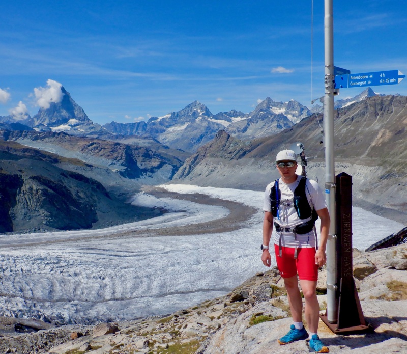
The half mile across the moraine to the trail was rather brutal. Every step was in ankle-deep silt and loose rock. I had to cross another short stretch of ice. There appeared to be no path up through the cliffs, but I continued upward, following the posts. Finally, the route crossed the final meltwater stream on a bridge. 2 ladders bolted ot the cliff finally provided an exist from the moraine. The ladders were vertical. Descending might have been disconcerting, but ascending was no problem. The route snaked through more cliffs, with occasional fixed lines offering security. It was a relief to finally reach the trail to Gornergrat. 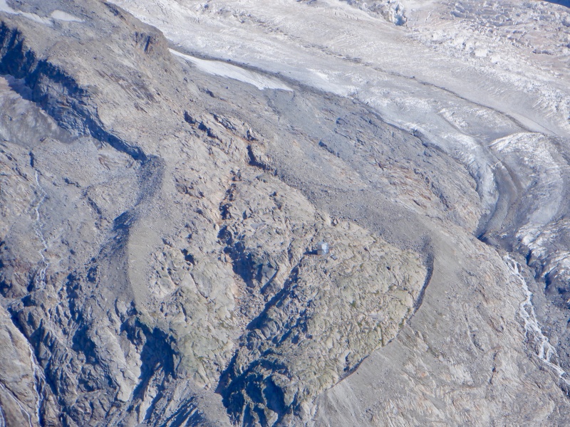
The sun started descending as I climbed back to the Gornergrat split. I occasionally saw the Klein Matterhorn cable car inching up the lines in front of the huge mountain backdrop. I paused for a moment at the bottom of the split, preparing for the difficult climb, then started up. It took 45 minutes to climb 1400’ straight up the slope. It was miserably steep. The view to the south was incredible but I focused on staggering up the hill. I was really blown up when I got to the top. 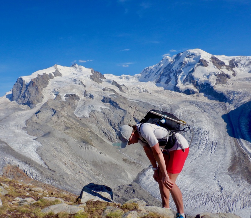
I sat on a rock, looking at Hohtalli and the glaciers across the sky. Hohtalli was close, but I wasn’t really motivated to go tag the summit. It would have essentially the same view, and the ski lift buildings removed some of the excitement. I was still a vertical mile above Zermatt and it was already a long day. 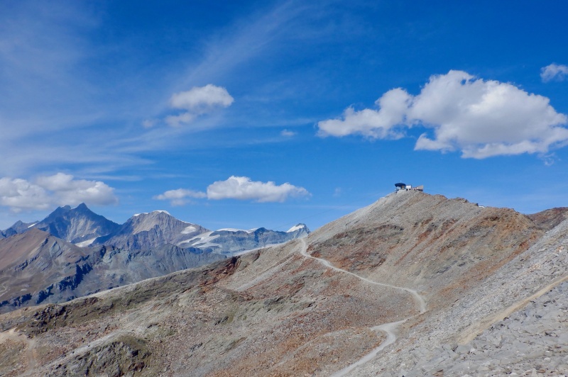
I took a break, looking through the binoculars and gazing at the mountains. I took more pictures at the Gornergrat Hotel, filled water in the train station and started down. The evening sun above Matterhorn provided a great backdrop. A herd of black-nose sheep grazed a few minutes down the trail. My legs felt alright as I steadily ran downhill. 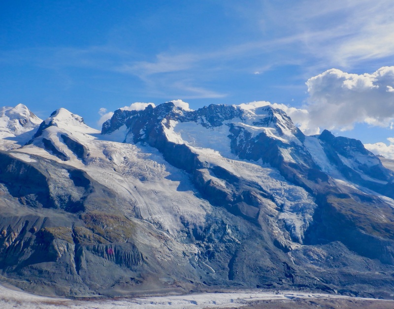
Zermatt came into view on the steeper slope above Riffelberg. The trails were quiet and all the lifts were done running for the day. When I reached Riffelalp, I decided to go down the service road instead of retracing the meandering trail route from the morning ascent. I plunged 1300’ down the hill in 18 minutes, looking up at the huge relief of Matterhorn as I neared the shadows in the valley. 
I hit the pavement at the bottom of the hill and followed the road into town. It went by some houses and the Klein Matterhorn lift station before ending at the main road next to the river. I walked back to the hotel, tired but very satisfied with the day. The terrain above Zermatt is really incredible and the views from the hut and Gornergrat were just as good as the scenery from Platthorn & Mettelhorn. Strava entry for Monte Rosa Loop: https://www.strava.com/activities/7572133928. 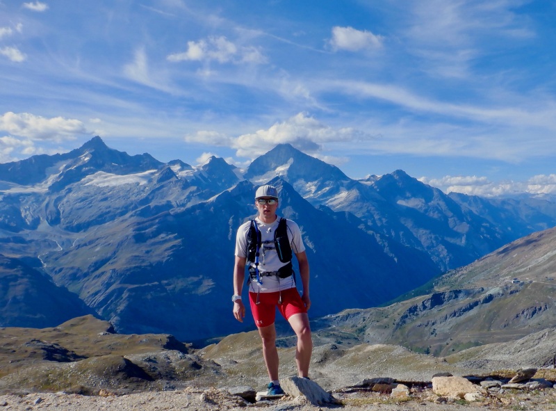
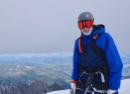
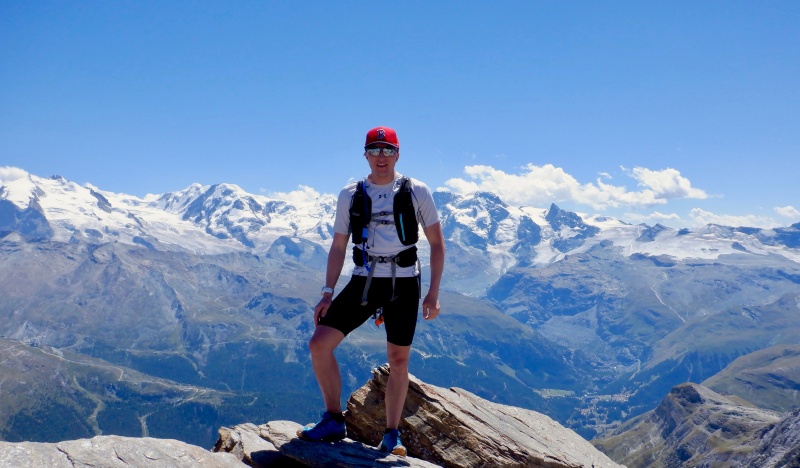
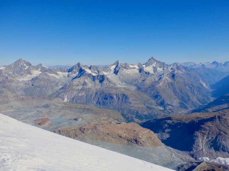
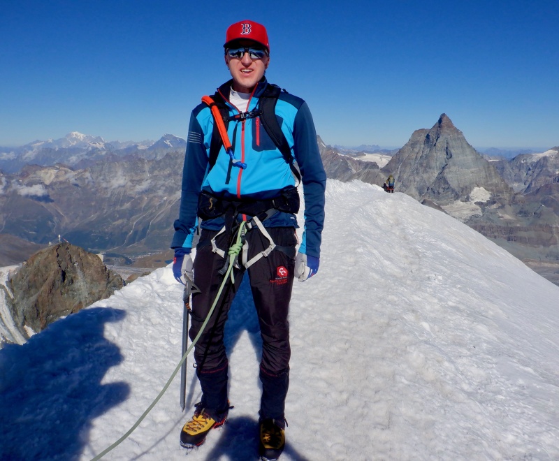
In 2018 I said that I wanted to stand atop one of the big glaciated peaks the next time I was in Switzerland, and on day 3 of the trip I did just that. I climbed Breithorn, one of the 4,000-meter peaks of the Alps, with a guided group. The 4000ers are the Alps version of the Colorado 14ers. While similar in summit elevation, the 4000ers are a much harder group of mountains to climb. Nearly all of them require glacier travel, huge vertical gain from the valley floor and steep, exposed climbing on difficult rock. As with the 14ers, there have been speed attempts through the years. The late, great Swiss alpinist Ueli Steck made the most notable FKT attempt: https://fastestknowntime.com/route/european-alps-82-4000ers. This particular outing underwent some evolution as I planned the trip. Initially, I thought about climbing it from the hotel in Zermatt. 20+ miles and +/- 8,200 vertical feet would be a big day. However, changing conditions through the summer necessitated a change to the plan. It was (and is) a very warm summer in the Alps. The glaciers are melting more than usual. The summer ski area in Zermatt actually closed at the end of July because there was so much melting and so many new crevasses. I didn't want to fall into a crevasse by myself, and as I planned the other routes I thought an easier day in the middle of the week would be good. I looked at several different guiding companies and ended up joining a group climb run by Zermatters (https://www.zermatters.ch/en), the local guiding service recommended by the Zermatt tourism office. Like everything else in Switzerland, the guided climb was not cheap. It cost 220 francs for the climb, plus 120 francs for the tram ride from Zermatt up to Klein Matterhorn. I screwed up the tram ride ticket and had to pay full price. I bought a Swiss Half-Fare pass for discounted train tickets for the whole trip. The discount was valid for Klein Matterhorn, but I bought the ticket on the website the night before, instead of at the automated ticket machine in the lift house. I woke up early and packed all the gear before walking to the Klein Matterhorn station. The guides arrived over about 15 minutes. I was in a group of 4- me, Klaus the guide and Thomas & Katja, a couple from Zurich. They didn’t speak much English so Klaus said things twice- German, then English. It took about 20 minutes to ride the trams from Zermatt to Furi to Trockener Steg to Klein Matterhorn. The steep ascents on the second & third legs were slightly vertiginous. I looked around in all directions, seeing where I’d been the last 2 days and appreciating the easy ascent. The final few minutes to Klein Matterhorn were steep, directly above the glacier moraine. 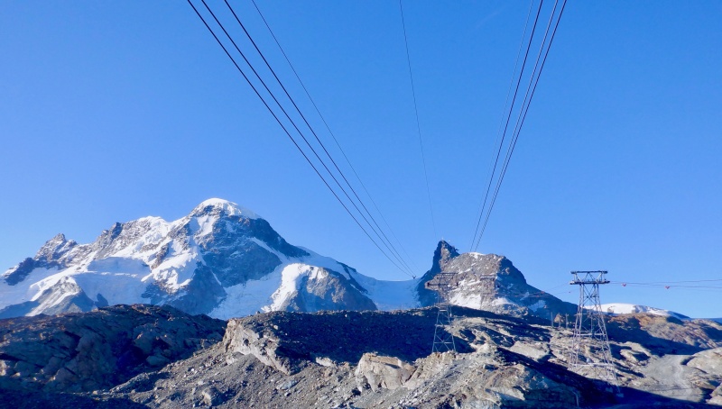
We exited the station and walked down the groomed ski trail a ways before stopping to gear up. Mt. Blanc was visible to the west. The ice was firm & crunchy. Even though it looks like snow, it really is ice. Yesterday and today, the glaciers stayed hard and crunchy even with strong sun in the middle of the day. We put on harnesses and roped up. Klaus led and I was in the back. It was about 30 degrees with no wind and no clouds. I put on gaiters and leashed up the ice axe. Most people used poles instead of an axe. 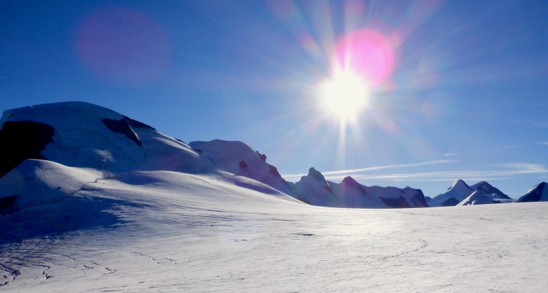
The pace across the plateau was very relaxed. There were many groups both ahead and behind, and some were already climbing up the slope. We crossed 2 shallow crevasses. The sun slowly rose higher over Castor & Pollux. We had about 10 feet of space between each person. As the slope steepened, we stopped to put on crampons. Gran Paradiso & Mt. Blanc provided a great backdrop. Klaus shortened the rope length to ~3 feet between each of us. 
I did not have a smooth start to the upper slope, as first my left, then my right crampon popped off. Dammit. I had to halt the group each time. The bails on the heel plates weren't flush on my boot welts, so the heel tension didn’t hold and the toe bails slipped off. I was able to create a tighter fit by running the forefoot bar back another click. Almost everyone on the mountain was wearing hybrid crampons, with an automatic heel plate and an over-boot toe plate. There was a roughly even mix of boots & hybrid shoes. Klaus was wearing La Sportiva Aequlibriums. 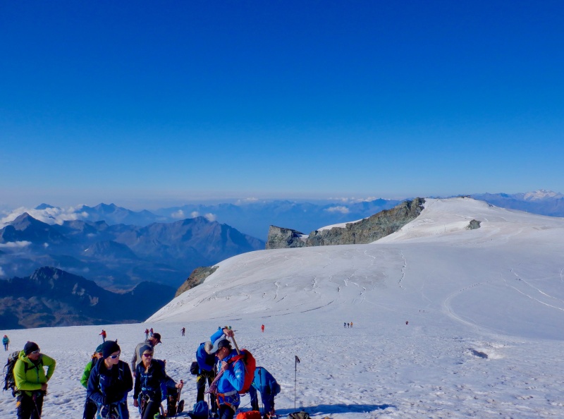
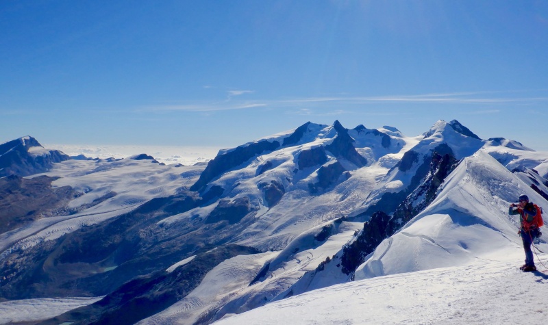
The climb on the upper mountain was rather underwhelming. We didn’t stop, so I couldn’t take any pictures. We hiked slowly, moving left or right for descending groups. 2 crevasse crossings were quite icy. I was thinking mostly that I didn’t want my crampons to come off again. One final snow bridge across the upper crevasse brought us to the summit ridge, a wide arete with huge views to the north. A few more minutes and we were on top. 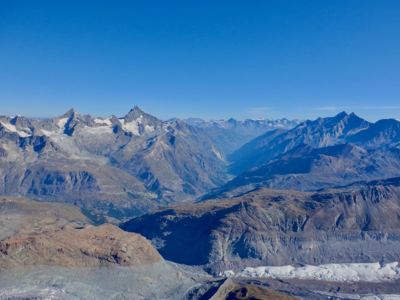
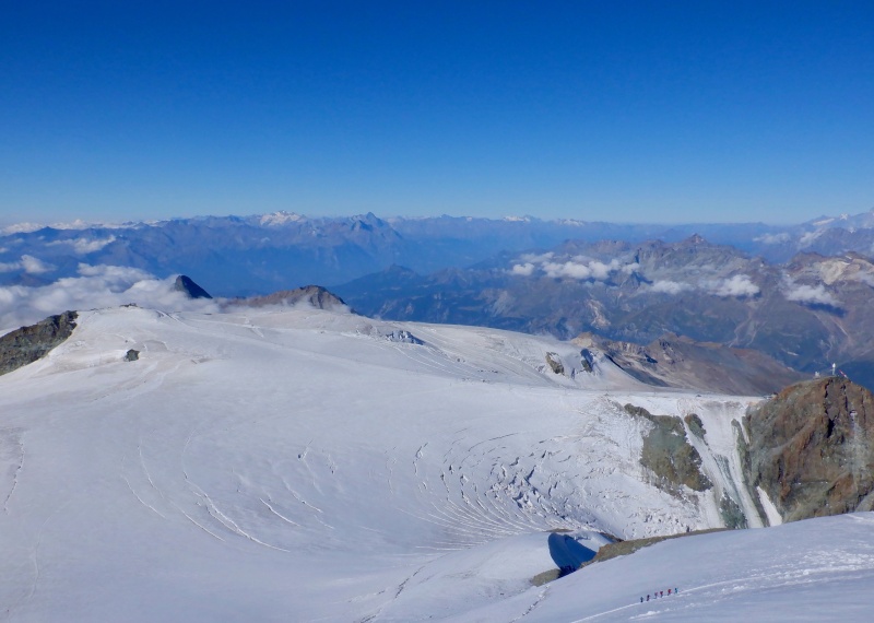
The scenery from the top was incredible- completely clear in all directions. Klaus pointed out some of the surrounding 4,000-meter peaks. It was crowded with all the other groups. We stayed for about 15 minutes- enough time to eat & drink, apply more sunscreen and take pictures. 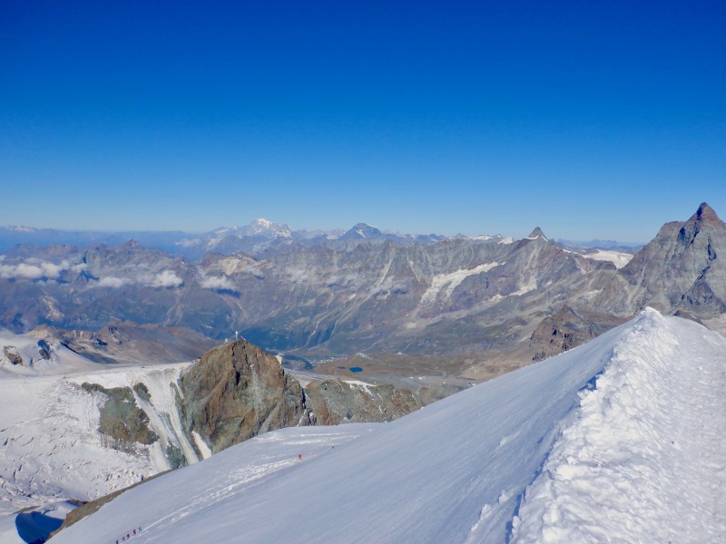
A few clouds appeared on the Italian side of Matterhorn as we started down. I led the descent. It wasn’t very steep, though the glacial ice made the footing slightly trickier than the snow plunge-stepping I normally encounter. We took another short break at the plateau to remove crampons, then very slowly walked back to Klein Matterhorn. The ice warmed in the sun but stayed mostly firm underfoot. We unroped when we reached the ski trail. 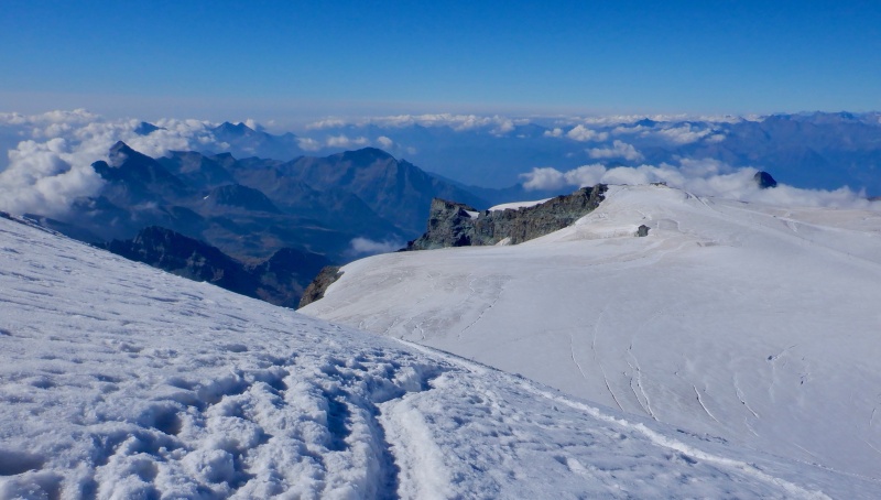
The climb wasn’t hard. I’ve done taller & steeper snow climbs in Colorado. The crevasse crossings were new, and the views were great. Worth 220 CHF? I guess. But next year on Mt. Blanc I’d still like to go solo. 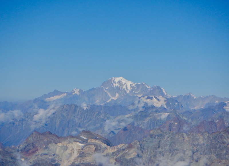

I stayed awhile at Klein Matterhorn. I adjusted my crampons to fix the fit- this was certainly the place to test them out. I moved the heel bails back to the rear eyelets, adjusted the tension on the heel bails and ran the forefoot bars farther back. The fit was much more secure as I walked out & back on the glacier. I also went up to the observation deck for a better look off the north & west sides of the mountain. 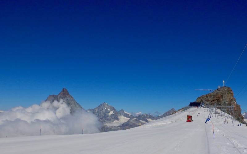
I had lunch in the panorama restaurant, took a final look at Mt. Blanc and got on the tram back to town. The lifts went from Klein Matterhorn to Trockener Steg to Schwarzsee to Furi to Zermatt. The scenery was again incredible, floating down through the sky. It was a hot walk back to the hotel in town in boots & winter clothes. Strava entry for Breithorn: https://www.strava.com/activities/7578115110. The next morning I made the short trip from Zermatt to Interlaken. I sat next to a big window on the train from Zermatt to Visp. I saw the top of Breithorn a few times and the edge of the glacier on the north side of Weisshorn. The trains from Visp to Spiez to Interlaken were hot and crowded. It was about 90 degrees in Interlaken. I really don't know how they survive without AC in Europe. I originally thought about running up & down Schynige Platt in the afternoon, but after all the big routes in Zermatt I decided to do something easier in Grindelwald. The train ride up the valley was familiar from when I stayed in Wengen 4 years ago. The scenery in Grindelwald is incredible. I didn't really get a chance to appreciate the Eiger from this side in 2018 because I happened to finish the Wengen -> Grindelwald run right as the train was leaving, so I had time for only 1 picture. Today, I had much more time to enjoy the scenery. 
I did a short run from the train station up to the Aellfluh panorama point, on the foothills north of town. The ascent was steep but quick. It's easy to gain elevation at such a low altitude. Legs felt good when I was done. 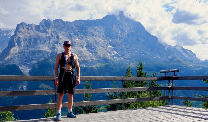
It was very hot in Grindelwald. After the run, I really needed to cool off, so I went down the hill to the river at the bottom of the valley. I found a tributary feeding into the main torrent. I waded in, then did 2 submersions up to my neck. It was shockingly, fantastically cold and utterly refreshing. I was numb after a few seconds but it was so soothing. The water was probably glacial ice an hour ago. The train ride back to Interlaken was bearable after the dunk. 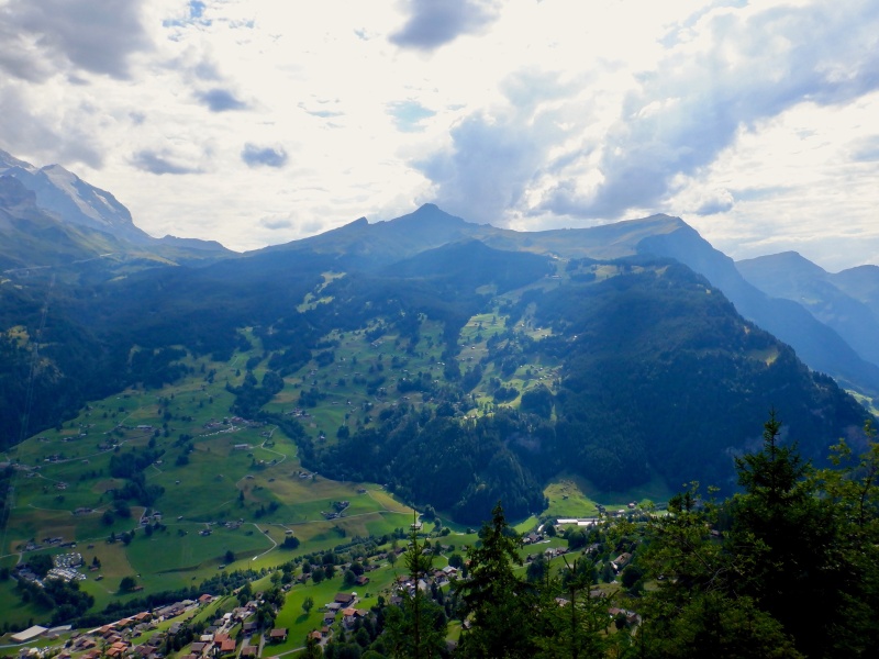
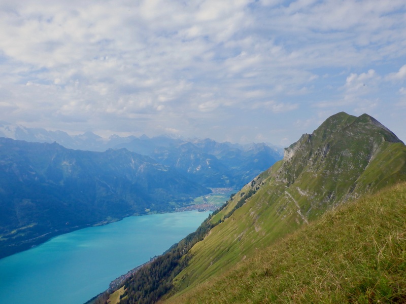
Strava entry for Grindelwald Aellfluh: https://www.strava.com/activities/7583086660. The final run of the trip was an attempt at the Hardergrat route above Interlaken. This is one of the best ridge runs in the Alps. There is really nothing like it in Colorado. It traverses the grassy, serrated ridge above the north side of the Brienzersee lake. The scenery is astounding. A foot-wide trail a vertical mile above the water, with the glaciated summits of the Bernese Oberland another 7,000 vertical feet above to the south. I've known about this route for years and I was excited to finally give it a try. The AlpsInsight website has several excellent reports & overviews of the Hardergrat route: https://elevation.alpsinsight.com/switzerland/hardergrat-trail-running/ https://alpsinsight.com/trip/hardergrat-trail/ https://alpsinsight.com/stories/the-hardergrat-interlaken-switzerland/ In general, I think AlpsInsight is the first place to look for route inspiration, information and planning if you are thinking about mountain objectives in the Alps. The easiest routes start with ~1 vertical mile of climbing but don't require any glacier crossings or climbing moves. If you are comfortable doing things like running Four Pass Loop in under 12 hours, snow climbing 14ers like Snowmass/Longs and moving through class 4/5 terrain with big exposure, most of the AlpsInsight routes will be a fun challenge. There are some outings that only the elite among us would even consider (Eiger West Face from Grindelwald with Ueli Steck, for example), but the majority of the routes are like those I detail in this report. Sleeping was difficult. It was 80+ degrees in my hotel room. I used a wet towel as a blanket. Around 1 AM thunder & lightning rolled through with some light rain. I worried it was raining up on the ridge- not good for the steep grass descents. Eventually the rain ended. I geared up slowly, loading a lot in the pack. All my usual stuff, plus rain gear, spikes for the descents, a lot of water and even the short ice axe in case I needed a third point of spiky contact on the unprotected downclimbs. The pack was heavy and it was already 60 degrees as I set off through Interlaken in the dark. The streets in town were quiet. I quickly reached the bottom of the mountain and started up the wide, rocky trail. The climb to Harder Kulm was mostly in the dark. It was humid and hot. My legs felt good but I was sweating profusely and the pack was really heavy. I glimpsed the lights of Interlaken through the trees. I reached Harder Kulm and turned off my headlamp. The sky was mostly clear. Sunlight slowly moved across Brienzersee. The Jungfrau Trio summits were covered in clouds and the Jungfraujoch light was still on. I took a break on the observation deck, then continued past the restaurant to the trail. 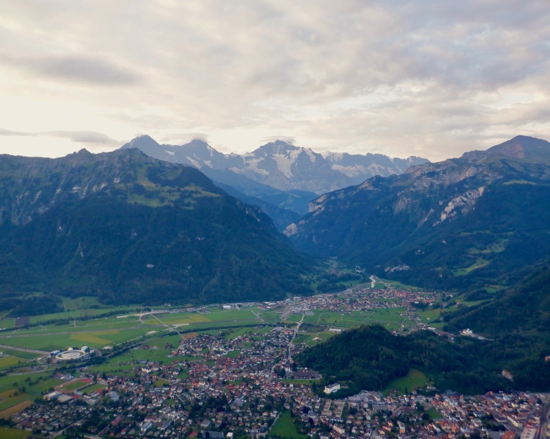
I did not spend enough time looking at the map, and I didn’t realize there was so much mileage between Harder Kulm & Augstmatthorn, where the ridge really begins. It took well over 2 hours to mostly hike the gradual trail. Trees obscured all the views, except for occasional open spots overlooking the valley to the north. This section was mostly runnable, and I lost time by not knowing the route better. I was still largely in the shade but it was viciously humid. Trails down the ridge occasionally snaked off to the right. Eventually I emerged from the trees and started up Suggiture. 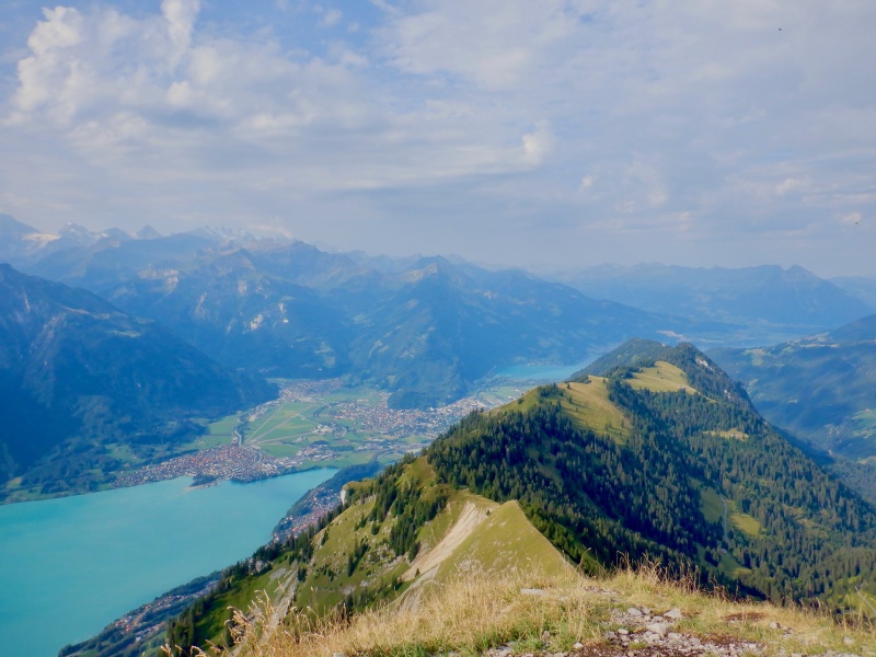
It was steep. I had the first doubtful thought of the day. I was almost 4 hours and a vertical mile into the day and I still wasn’t into the real ridge. The ground abruptly fell away as I reached the top of Suggiture. The views were enormous. Brienzersee was directly below, a few boats cutting across the turquoise water. The glaciated summits to the south fought with the clouds to be the highest thing in the sky. I got my first real look at the ridge, stretching jaggedly to Brienzer Rothorn in the distance. 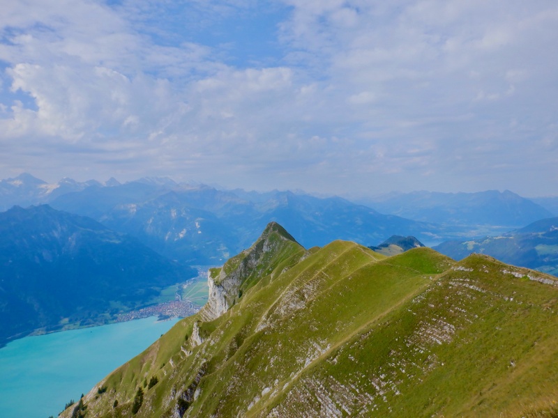
I ran over to Augstmatthorn, passing a few people going the other way. The trail was dry- evidently last night’s storm wasn’t too strong. Now that I was on the ridge, I felt more confident about actually completing the route. The descent off Augstmatthorn was quite steep. A dirt trail stepped precipitously down the hill. A chain wound through some metal posts offered extra balance. In just half a mile the trail dropped almost 900 feet. I was still way up above the lake. 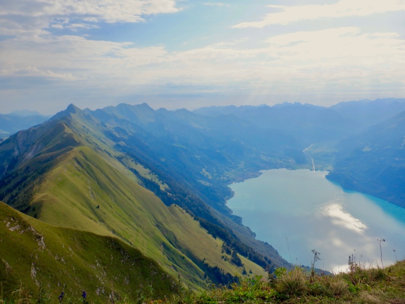
It took another hour to go up, over & down the next 2 climbs. The second descent was steep enough to turn me face-in. My legs still felt fine but I was uncomfortably hot. I tried to drink sparingly but every few minutes I had to have water. I thought about how great it would feel to jump into Brienzersee. Breinzer Rothorn was still far away and each small summit was a few hundred feet of steep, slow hiking. To the north, the occasional sounds of clanking cowbells & revving tractors drifted up from the valley. I looked at the map and saw the next good stopping point was on the far side of Schierenhireli. I trudged painfully up to the summit, then negotiated another steep no-slip downclimb. I flopped on the bench at Allgaulicka, roasting hot and unsure if I could continue. I ate a few bites as someone came by going the other direction. I drank more than I intended out of my collapsible bottle. After taking some pictures I sat for awhile, thinking about what I should do. It was very hot and the clouds weren’t doing much to block the sun. No rain or cooler weather for at least 4 more hours. The next bailout option was on the east side of Tannhorn, and would require a much longer descent than the one right in front of me. I had almost 5 miles and 2500’ of climbing to get to Brienzer Rothorn. With my slow pace, I guessed it would be another 2.5-3 hours, in the hottest part of the day. Even if I did just Tannhorn I’d still have 1000’+ of ascent and the long descent to Brienz. I wasn’t confident my water would last. Tannhorn was close, but then the ridge bent north and meandered before reaching Brienzer Rothorn. Running out of water way up there would not be good. My Camel was down to about 1L and the collapsible bottle was almost empty. 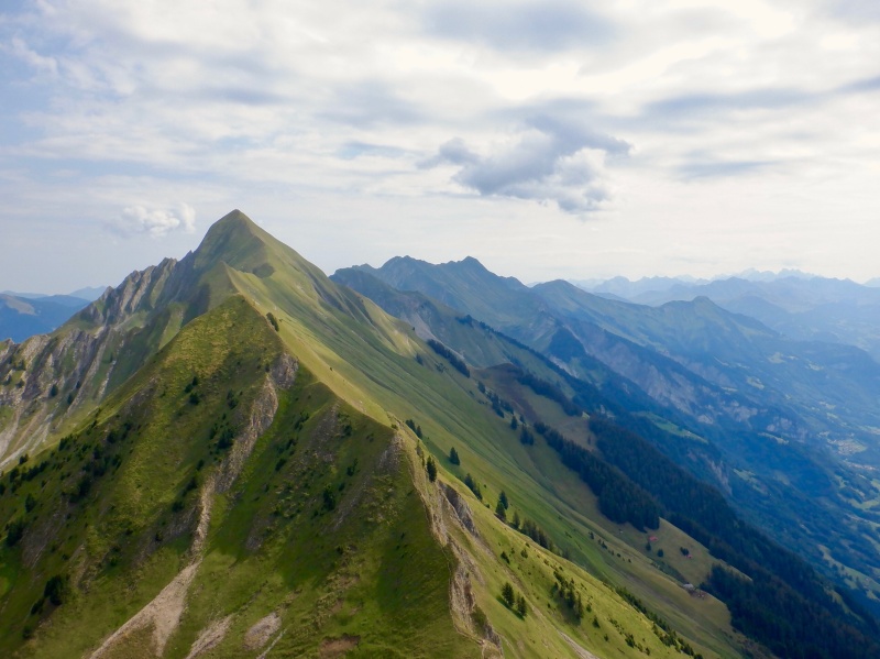
I reluctantly decided to bail to Oberried and give up on the rest of the route. The heat was too much. Really frustrating. My legs still felt great and I was confident I could finish the ridge, if only I had more water and it wasn’t so hot. I sat awhile longer, taking in the spectacular view, then slowly started down the trail to Oberried. Within minutes I was covered in sweat again as the heat radiated up from the grass. Another few minutes, but many vertical feet, brought me to a water trough fed by a hose. I filled the flask, chugged all of it and filled again. Should I fill the Camel and go back up? No. I was over 1000’ below the ridge, and the long break at Allgaulicka put me well behind schedule. 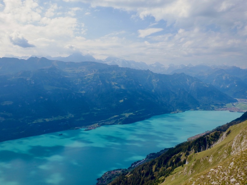
I descended the remaining 4000’ down to Oberried in an hour. Even at a slow piece the vertical relief quickly disappeared because the hill was so steep. Once in the trees the trail was covered in a lot of plant debris. An alpine goat bounded over some cut trees. I dropped steadily, watching the lake grow larger as the heat went up. A final steep descent through some farm pastures put me on the shores of Brienzersee. I took off my shoes, pack & shirt and waded in. The water was cool and incredibly refreshing. I spent 20 minutes sitting in the shallows and swimming around. The clouds slid slowly over the peaks to the south. I looked up at Breinzer Rothorn, upset with the outcome of the day. After 4 great days in Zermatt I really wanted to finish this route to end the week having accomplished everything I planned. After cooling off, I got a train ticket back to Interlaken. Cold rain started pouring at 6 PM and really cooled down the temperature. I will be back for another try at this route. It is an absolute monster. The conditions weren’t great and I made some mistakes that eventually caught up to me. I need to start about 2 hours earlier, to arrive at Augstmatthorn at sunrise. An easier day before the run, with more sleep, will also help. Avoiding the heat is key. I might add it to the Chamonix trip next year. Strava entry for Hardergrat: https://www.strava.com/activities/7588773327. Travel back to Colorado took 2 days: trains from Interlaken to Zurich one day, then the same flights but in reverse the next day. The flights were on time and all my baggage arrived without problems. The totals for the week were 26 hours 48 minutes in 6 days of training, covering 59.95 miles and 27,418' ascent/descent. Other than the last half of the Hardergrat run, I completed all the planned objectives. The GPS tracks for each outing are in the Strava entries, along with many more photos than I could include in this report. This week in Switzerland increased my confidence for the trip to Chamonix next summer. The main goal for that trip, and one that I've been working towards for 3+ years, is to climb Mt. Blanc via the normal route in a single push, starting and ending in Les Houches. I'm still building the skills and mentality for such a massive effort, but a second successful trip to the Alps has brought that goal within reach. Dream big, train hard. Thumbnails for uploaded photos (click to open slideshow): ")
")
")
")
")
")
")
")
")
")
")
")
")
")
")
")
")
")
")
")
")
")
")
")
")
")
")
")
")
")
")
")
")
")
")
")
")
")
")
")
")
")
")
")
")
")
")
")
")
")
|
| Comments or Questions | |||||||||
|---|---|---|---|---|---|---|---|---|---|
|
Caution: The information contained in this report may not be accurate and should not be the only resource used in preparation for your climb. Failure to have the necessary experience, physical conditioning, supplies or equipment can result in injury or death. 14ers.com and the author(s) of this report provide no warranties, either express or implied, that the information provided is accurate or reliable. By using the information provided, you agree to indemnify and hold harmless 14ers.com and the report author(s) with respect to any claims and demands against them, including any attorney fees and expenses. Please read the 14ers.com Safety and Disclaimer pages for more information.
Please respect private property: 14ers.com supports the rights of private landowners to determine how and by whom their land will be used. In Colorado, it is your responsibility to determine if land is private and to obtain the appropriate permission before entering the property.