Download Agreement, Release, and Acknowledgement of Risk:
You (the person requesting this file download) fully understand mountain climbing ("Activity") involves risks and dangers of serious bodily injury, including permanent disability, paralysis, and death ("Risks") and you fully accept and assume all such risks and all responsibility for losses, costs, and damages you incur as a result of your participation in this Activity.
You acknowledge that information in the file you have chosen to download may not be accurate and may contain errors. You agree to assume all risks when using this information and agree to release and discharge 14ers.com, 14ers Inc. and the author(s) of such information (collectively, the "Released Parties").
You hereby discharge the Released Parties from all damages, actions, claims and liabilities of any nature, specifically including, but not limited to, damages, actions, claims and liabilities arising from or related to the negligence of the Released Parties. You further agree to indemnify, hold harmless and defend 14ers.com, 14ers Inc. and each of the other Released Parties from and against any loss, damage, liability and expense, including costs and attorney fees, incurred by 14ers.com, 14ers Inc. or any of the other Released Parties as a result of you using information provided on the 14ers.com or 14ers Inc. websites.
You have read this agreement, fully understand its terms and intend it to be a complete and unconditional release of all liability to the greatest extent allowed by law and agree that if any portion of this agreement is held to be invalid the balance, notwithstanding, shall continue in full force and effect.
By clicking "OK" you agree to these terms. If you DO NOT agree, click "Cancel"...
Cent 94/100 (Trad list) Cent 92/101 (New Lidar List) Mostly following the West Face route described by Roach. The GPX route attached is one from an older TR, but it is very accurate towards the standard route.
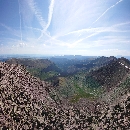
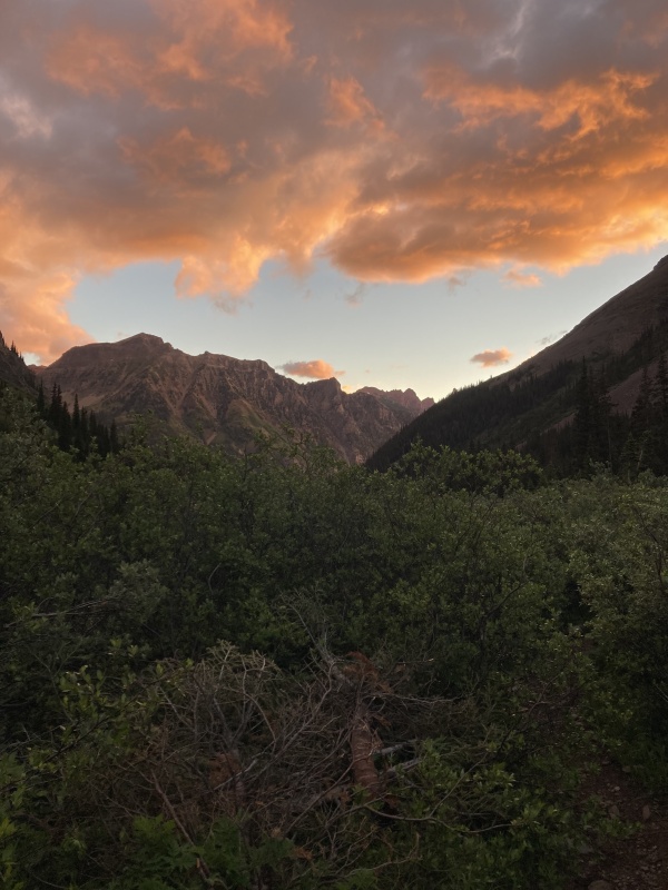
Thunder Pyramid has loomed large in my centennial journey. I have long heard beta that its the worse, loosest, and gnarliest cent, and there has been one failed climb and a few failed trips due to weather. Today I was determined that nothing would stand in my way. My partner had to bail last minute so this would be a solo ascent, but the weather looked promising, and even though I wanted to do this as a full snow climb there seemed to be a little snow to make the trip easier. After a very bleary-eyed early morning I parked at the trailhead and left at 4:10am. I made some good time up to the W. Maroon Creek crossing where I was treated to a an amazing sunrise
Sunrise near the crossing to W. Maroon Creek
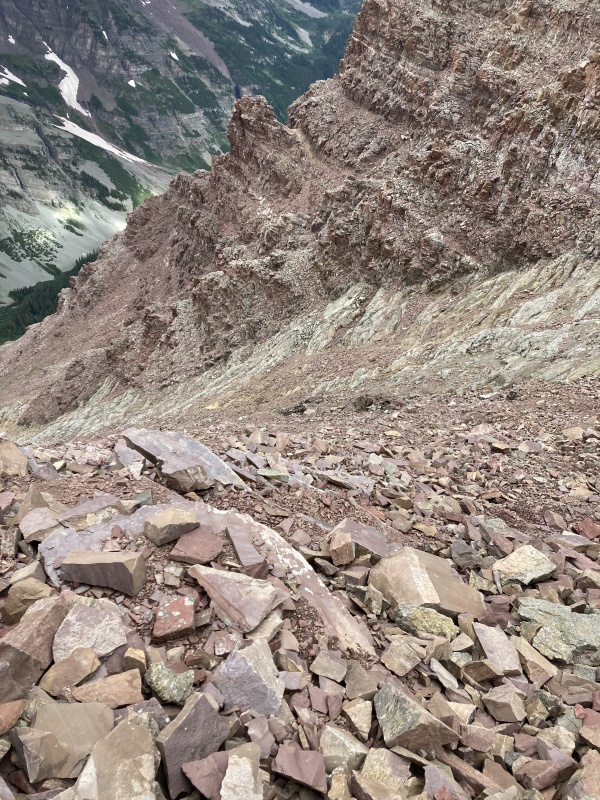
The snow bridge over the creek is long gone, but its still early enough in the season to be too high to rock-hop over. The cold sunrise temps made a very uncomfortable time taking off the boots and wading the creek, but it turned out to be a relatively easy crossing. I expect that in a week or two the creek will drop enough to hop across. After the creek the GPX was very helpful for where to turn off the trail because there isn't any cairn or indication where to point uphill. Follow two rocky gulleys up the weakness in the cliff bands. The talus is all quite stable so I was able to make quick progress. This trip report proved very helpful finding my way up through the lower sections of the uphill https://www.14ers.com/php14ers/tripreport.php?trip=11740
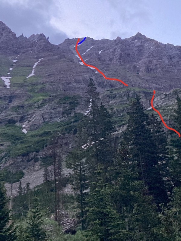
Overview of the route from near the creek. Red is the ascent route up the White Gully, Blue was my descent
After some easy hiking up the cliff bands the route enters the relative flat entry into Len Shoemaker basin. The White Gully ends in a waterfall, but the route climbs the grassy slope just to the climbers right of the waterfall. Once you get into the gully its some easy climbing. This time of year there is an initial snow field around 12,500', but its can be easily bypassed.
The first snow filed
After this, there are a few long, thin snow fields in the gully itself. My initial plan was to snow climb as much as possible, but the snow was relatively rotten and steep enough that with just my micro-spikes it took more energy than it was worth to climb the snow. On either side of the gully there was easy class 3 scrambling which proved much more efficient for me personally. A few weeks before this I think some proper crampons would make it a much easier climb. The white gully has its loose sections, but in general I thought there were always more stable options. The gully was more stable than the worst parts of Pyramid or S. Maroon, but it was much longer. The worst of the route was yet to come, but up until you split with the gully I thought the route was loose, but not nearly as bad as other reports mention
Near 13,600 the route that Roach describes splits off to the climbers right up a very loose slope. I decided that the rock looked more stable continuing the gully towards the main peak. I haven't seen others write about this more direct approach which was the main reason I wanted to write this up. The top of the mountain is is basically a pile or rubble which offers a variety of options. You could really choose any path you want, so I decided to work up the large band of white rock and after I was on top it seemed relatively easy to just keep going. I found maybe 2 moves of class 4, but without the snow you could easily keep it to class 3. It was steeper, so I think its better to ascend, but might make for a slightly spicier descent. Overall I think I might recommend this approach for people comfortable class 3/4 scrambling, but if you really want to keep things less technical than heading up the less steep standard route might be more advisable. Variety is the spice of life though, so pick your poison
Red shows the ascent route, Blue shows the descent route
A quick hop up the direct route leads to the summit ridge. I ended up just to the climbers right of the proper summit, but it was an easy scramble to the true summit which avoided some of the more exposed moved on the "standard route"
Looking at the summit from where I joined the ridge
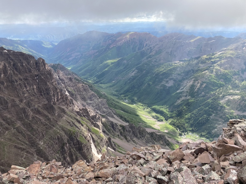
The summit was amazing. The view of the Elks are outstanding. Pyramid rises from its snake-like ridge just a half mile away, and the Bells are looming across the valley. Today there was some low handing clouds which made everything more mysterious, and having the summit to myself was pretty darn magical
Looking down on E. Maroon Creek
I could have descended the same route I came up, but because it was steeper I thought that some of the loose sections might be a little too spicy. I decided to head down the standard route (per Roach) and it turned out to be relatively straight forward. I think it was looser, but you could scree surf down some it was generally more mild. Rockfall is a DEFINITE risk, so if you are in a group or have people below you be supremely careful.
A look down on the standard descent (show in blue in the previous images)
While the snow wasn't great on the way up, it provided around 700 feet of glorious plunge-stepping on the way down which made for a much faster descent. In general the descent was tiring on the loose rock, but after such an amazing summit it was worth it. Once back to the main trail, there was just a quick (and cold) fording of W. Maroon Creek and a brain-dead hike back to the car.
Thunder Pyramid gets a really bad rap, but I think it was a solid route. I think it was easier than some of the other Cent routes (Hagerman, Snowmass W Face, Teakettle, etc). It kinda sucks, but is in the same ballpark as others so don't feel intimidated. Get out an embrace the Choss. One step closer to closing out the Cents!
My GPS Tracks on Google Maps (made from a .GPX file upload):
Thanks for the trip report, I used it yesterday for my summit of TP. I agree with your assessment on the lower portion of the mountain. Very straightforward with stable rock and good paths up the grassy slopes. The White Gulley is a whole other beast, that thing was tough! Scrambling up on all fours and massive rocks collapsing underfoot. I was the only person on the mountain thankfully. I would say the descent of TP was the most difficult of any mountain I've done to this point. I took it very slow and meticulous. I felt any mistake would be fatal. Awesome mountain and incredible summit, but definitely on the never do again list.
Caution: The information contained in this report may not be accurate and should not be the only resource used in preparation for your climb. Failure to have the necessary experience, physical conditioning, supplies or equipment can result in injury or death. 14ers.com and the author(s) of this report provide no warranties, either express or implied, that the information provided is accurate or reliable. By using the information provided, you agree to indemnify and hold harmless 14ers.com and the report author(s) with respect to any claims and demands against them, including any attorney fees and expenses. Please read the 14ers.com Safety and Disclaimer pages for more information.
Please respect private property: 14ers.com supports the rights of private landowners to determine how and by whom their land will be used. In Colorado, it is your responsibility to determine if land is private and to obtain the appropriate permission before entering the property.


")
")
")
")
")
")
")