Download Agreement, Release, and Acknowledgement of Risk:
You (the person requesting this file download) fully understand mountain climbing ("Activity") involves risks and dangers of serious bodily injury, including permanent disability, paralysis, and death ("Risks") and you fully accept and assume all such risks and all responsibility for losses, costs, and damages you incur as a result of your participation in this Activity.
You acknowledge that information in the file you have chosen to download may not be accurate and may contain errors. You agree to assume all risks when using this information and agree to release and discharge 14ers.com, 14ers Inc. and the author(s) of such information (collectively, the "Released Parties").
You hereby discharge the Released Parties from all damages, actions, claims and liabilities of any nature, specifically including, but not limited to, damages, actions, claims and liabilities arising from or related to the negligence of the Released Parties. You further agree to indemnify, hold harmless and defend 14ers.com, 14ers Inc. and each of the other Released Parties from and against any loss, damage, liability and expense, including costs and attorney fees, incurred by 14ers.com, 14ers Inc. or any of the other Released Parties as a result of you using information provided on the 14ers.com or 14ers Inc. websites.
You have read this agreement, fully understand its terms and intend it to be a complete and unconditional release of all liability to the greatest extent allowed by law and agree that if any portion of this agreement is held to be invalid the balance, notwithstanding, shall continue in full force and effect.
By clicking "OK" you agree to these terms. If you DO NOT agree, click "Cancel"...
The newly "discovered" ranked 13ers via LiDAR has me motivated to return to a past obsession – 13er bagging. The routes described below I climbed were undoubtedly not the shortest or the easiest but seemed the most aesthetic. It's about enjoying the climbing and not just checking a box; in hindsight, how I perhaps should have climbed some of my prior peaks.
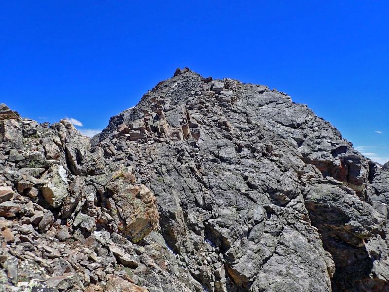
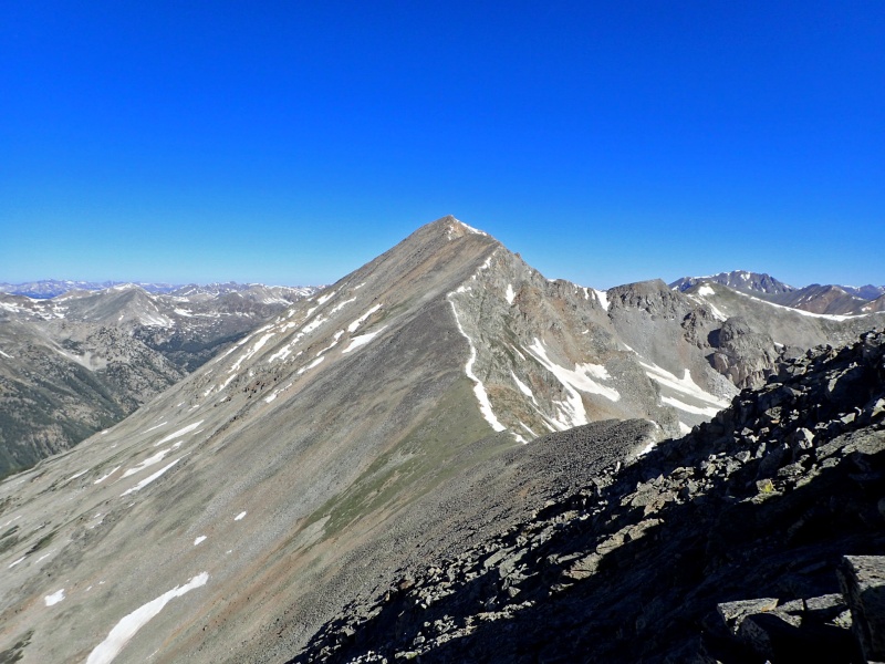
Point 13,556 from the Lost Man Trail
It's been less than a week since I tested positive for COVID. I was feeling alright and was certainly going stir crazy from isolation in the house (I was past the 5 day isolation period). With a good weather forecast without storms, I casually left Denver at 9 AM and made the 3 hour drive over Independence Pass. I parked at the Linkins Lake Trailhead located at a large switchback on the western side of Independence Pass (~1.9 miles from the summit of the pass) and began hiking up the Linkins Lake Trail (#1979) around 12:30 PM. I took my pace very slow to see how my stamina would hold up. After 0.2 mile of hiking, I crossed a stream and reached a trail junction. I departed the Linkins Lake Trail and continued on the well-signed Lost Man Trail (right).
I continued up the well-traveled Lost Man Trail through a willow-strewn valley for an additional 1.4 miles. Before reaching Independence Lake after crossing a little stream at ~12,460', I left the Lost Man Trail and began hiking towards Point 13,556's north ridge since the ridge looked like an appetizing scramble. A reasonably stable talus grind east led me to the ridge's base at ~13,240'. I took a short break and then continued south up the ridge crest. The ridge looked more challenging than it actually climbed. Acceptably sound rock guided me to the summit (class 2+) where I easily avoided any tricky sections on the ridge's left or right side. For the descent, I hiked down Point 13,556's class 2 talus ridge to the top of a scree-filled gully at ~13,360' and headed west down the gully back towards Independence Lake. Some have taken this gully for an ascent route which would be terrible considering all of the loose rock. A quick scree-ski had me back in the basin and on the trail. I returned back to the parking area around 3:20 PM and felt pretty good. I made the quick drive to the Rockdale Trailhead for my next objective and slept a solid 11 hours. Far from fully recovered.
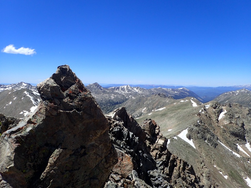
Point 13,556' north ridgePoint 13,556' north ridge challenges
Summit viewMap
Point 13,486 (labeled as Point 13,472)
June 21, 2022
~11.4 miles, ~3,700 gain. (If I parked at Clohesy, ~5.4 miles, ~2,700 gain)
TH: Rockdale (could have been Clohesy Lake)
Max difficulty: Class 2, Moderate Snow
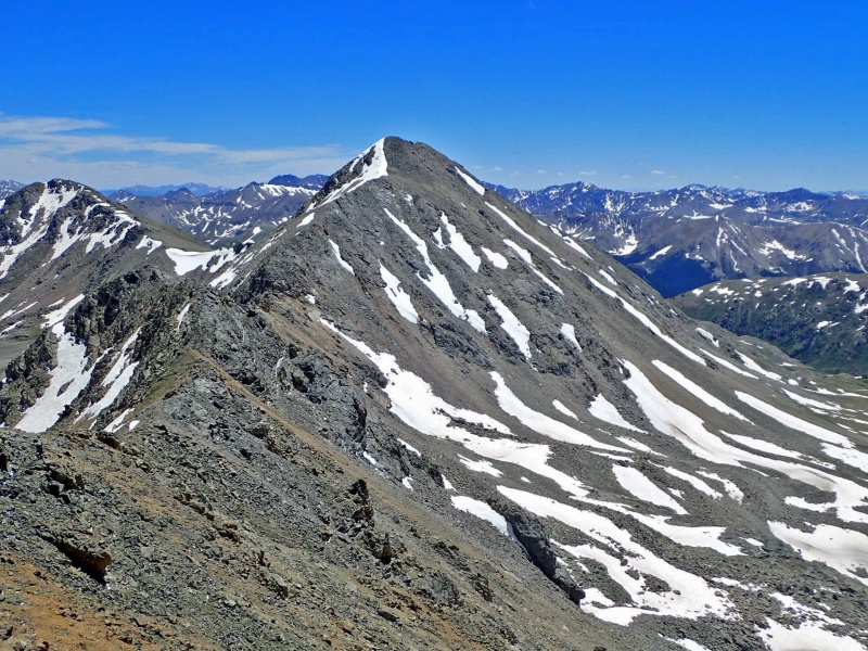
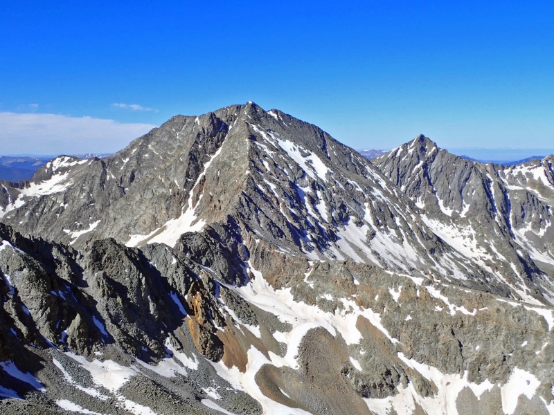
Point 13,486 from Lois Lake
Ah, the Rockdale Trailhead river crossing..... Over 20 years ago, I got a vehicle stuck crossing Clear Creek in May. I'm not as bold with water crossings, and the water seemed high, so I parked at the base of the Clohesy Lake Road instead. The following morning, I crossed the river with sandals around 5:30 AM, a rude awakening, and began hiking up the Clohesy Lake Road. Gaining the cirque north of Point 13,486 (labeled as Point 13,472) was not an easy task. I should have crossed the Lake Fork north of Clohesy Lake, followed a faint trail halfway around the lake counterclockwise, and then continued following a faint semi-cairned trail into the cirque – I found this "trail" on my descent. This trail is far from ideal.
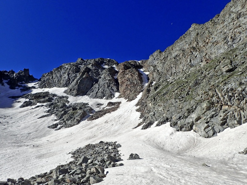
I ended up hiking south of Clohesy Lake before crossing Lake Fork and then bushwhacked, not-that-great, west into the cirque. Lots of willows followed by downed timber made progress slow. Once through the bushwhacking, I continued along Lois Lake's north shore into the talus-strewn cirque. Not paying attention to my GPS, I was suckered into a good looking couloir that wasn't my main objective. I ended up hiking into the eastern, northern cirque. Unfortunately, the harder, more inspiring snow line was discontinuous and melted out in sections; I probably missed the climbing window by a week or two.
Inspiring but yet melted couloir
Fortunately, I could traverse west around a rock rib without losing too much elevation to reach the western north cirque. Once in the western cirque, my original snow climb was obvious. I enjoyed 500 feet of moderate snow climbing (30-35 degrees) until intersecting Point 13,486's east ridge at 13,220' (continuous snow could be climbed from ~12,200' to the saddle). From the top of the couloir, I rambled west up the ridge (class 2, some might argue class 3) until intersecting Point 13,486's north ridge. From there, it was a short class 2 rally south to the top where I arrived at 9:20 AM. The descent was uneventful and a little easier since I found the "trail" back to Clohesy Lake. On my descent, I ran into two vehicles that made the Clear Creek river crossing, so it's manageable this time of year. I arrived back at the car at 12:20 PM, made a quick drive to Ellingwood Ridge and slept another 11 hours.
Point 13,486's north face couloirPoint 13,486's north face couloirPoint 13,486's north face couloir (taken on the descent).Point 13,486's east ridge (class 2).Huron from the summit.Apostles.
I'm not entirely sure the north face couloir on Point 13,486 would be worth the invested approach from Rockdale; however, it's probably worth the effort if parked at Clohesy Lake and you could locate the “trail” into the northern cirque.
Map
My GPS Tracks on Google Maps (made from a .GPX file upload):
You're more productive during your bout with covid than I am. I managed to somehow get these two by accident when running ridges between other high points, so some luck there with the Lidar.
I've previously wondered whether one can string together Huron and 13,472 via the connecting ridge. The second-to-last of your pictures does not show any obvious difficulties, but I haven't been able to see anyone report on that ridge. From seeing it close-up, do you have thoughts on the matter?
Huron goes pretty easily to 13472. I did that many years ago in route to the Three Apostles (and, at that time, over unranked 472 and ranked 517, but now I guess they are both ranked!). My TR is on here, but it does not spend much time on Huron to 472, as that was the easy part.
Ah, thanks a lot, @Marmot72! I love looping things together and had wondered whether one could do something like starting at Winfield, hiking all the way up the valley, and then doing the long ridge via 13517, 13472, Huron, Browns, 13462, and Middle Mountain. It's good to know that one can -- I should do that one day!
Caution: The information contained in this report may not be accurate and should not be the only resource used in preparation for your climb. Failure to have the necessary experience, physical conditioning, supplies or equipment can result in injury or death. 14ers.com and the author(s) of this report provide no warranties, either express or implied, that the information provided is accurate or reliable. By using the information provided, you agree to indemnify and hold harmless 14ers.com and the report author(s) with respect to any claims and demands against them, including any attorney fees and expenses. Please read the 14ers.com Safety and Disclaimer pages for more information.
Please respect private property: 14ers.com supports the rights of private landowners to determine how and by whom their land will be used. In Colorado, it is your responsibility to determine if land is private and to obtain the appropriate permission before entering the property.


")
")
")
")
")
")
")
")
")
")
")
")
")
")


