Download Agreement, Release, and Acknowledgement of Risk:
You (the person requesting this file download) fully understand mountain climbing ("Activity") involves risks and dangers of serious bodily injury, including permanent disability, paralysis, and death ("Risks") and you fully accept and assume all such risks and all responsibility for losses, costs, and damages you incur as a result of your participation in this Activity.
You acknowledge that information in the file you have chosen to download may not be accurate and may contain errors. You agree to assume all risks when using this information and agree to release and discharge 14ers.com, 14ers Inc. and the author(s) of such information (collectively, the "Released Parties").
You hereby discharge the Released Parties from all damages, actions, claims and liabilities of any nature, specifically including, but not limited to, damages, actions, claims and liabilities arising from or related to the negligence of the Released Parties. You further agree to indemnify, hold harmless and defend 14ers.com, 14ers Inc. and each of the other Released Parties from and against any loss, damage, liability and expense, including costs and attorney fees, incurred by 14ers.com, 14ers Inc. or any of the other Released Parties as a result of you using information provided on the 14ers.com or 14ers Inc. websites.
You have read this agreement, fully understand its terms and intend it to be a complete and unconditional release of all liability to the greatest extent allowed by law and agree that if any portion of this agreement is held to be invalid the balance, notwithstanding, shall continue in full force and effect.
By clicking "OK" you agree to these terms. If you DO NOT agree, click "Cancel"...
In March 2022, my brother, Ben, and I successfully climbed Mount Sanford (16,237’) in the Wrangell Mountain Range of Alaska. Starting from the nearest road, we traveled 82 miles and 15,000 vertical feet in 3 ½ days, summited in -55° weather, and skied 12,000 continuous feet directly off the summit.
I don’t remember exactly where the idea started, but Mount Sanford has been on my radar for several years now. In June of 2021, I had tentative plans to fly in and attempt it, but this idea fell through at the last minute in favor of other adventures closer to home in Colorado. While searching for beta, I came across a Trip Report by Luc Mehl, who attempted to climb and ski Sanford from the road in 2011. He made it all the way to 15,000’ before running out of daylight, but came back two weeks later and successfully summited using snowmachines for the approach.
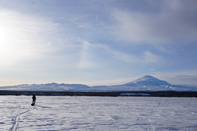
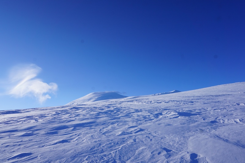
Starting our Adventure with Sanford Towering in the Distance
Lacking snowmachines and not wanting to turn this into a two-week fly-in expedition, we decided that walking in from the road for a human-powered attempt would be our best option. We flew from Denver to Anchorage on March 10th and were immediately shut down by the weather. Armed with free housing (thanks mom and dad!), and the ability to work remotely, we not-so-patiently waited to see if a weather window would open. After two weeks a few good days finally lined up and we decided to give it a shot.
We were up early on March 24th to make the four-hour drive from Anchorage to the Chistochina River Trail Pulloff and were moving by 9:00am. The route starts by following the Chistochina river for two miles until it merges with the Copper River. This section is the primary reason for doing this trip in March; wait another month for warmer temps and risk an open water crossing. I was concerned that crossing the Copper might be tricky, but it turned out to be a non-issue. Both rivers were still completely frozen over. We followed the Copper upstream for a mile before turning onto Boulder Creek for the next 22 miles.
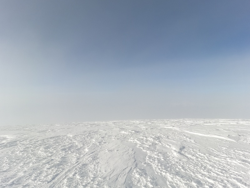
The approach up Boulder Creek is long, flat, and monotonous. We were very fortunate to find an old snowmachine track right out of the parking lot that continued the entire way up the Boulder Creek drainage (apparently this is a common area for trapping in the winter). Deep snow covered the creek, and without the firm snowmachine track to follow I don’t think we would have made it. We traveled 19 miles on Day 1. The mountain still looked very far away.
The Never-Ending Approach up Boulder CreekSanford from Camp the First Night
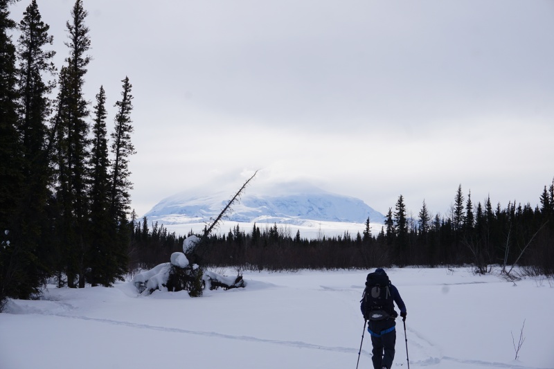
Day 2 started by grinding out another 6 miles up Boulder Creek until it merges with the Sheep Creek drainage. Finally, we’ve made it to the base of the mountain! We turn right and begin gradually gaining elevation until we reach a large plateau at 5000’ where most expeditions fly into. Here we ditch our sleds and shoulder the entire 60lbs of gear for the climb up to high camp.
Happy to be off Boulder Creek and Heading up the Sheep Creek DrainageApproaching the Sheep Glacier
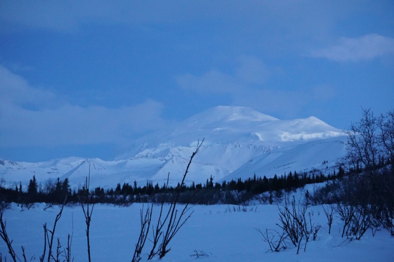
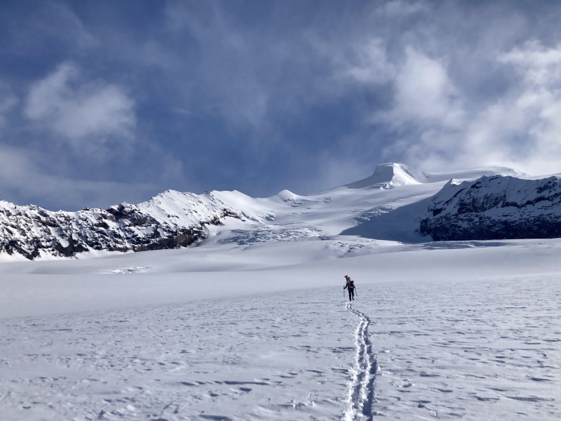
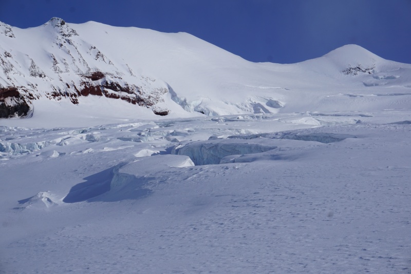
We weave through the moraine and onto the Sheep glacier at 6000’. There are some large cracks on the lower glacier between 7,000’ and 8,500’, but they are easily spotted and given a wide girth. Snow bridges are bombproof this time of year, and we did not rope up for any part of the glacier. We had hoped to make a high camp near 10,000’, but by 7:30pm we were running out of daylight (and energy) and forced to stop at 9,000’. The ambient air temperature was -15° before the sun has set.
Crevasse Field at 8000'. Avoided to Climbers RightGaining Elevation on the Sheep GlacierWe Made Camp at the Top of this Ridge at 9000'
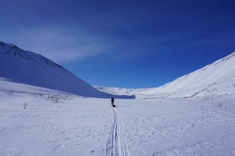
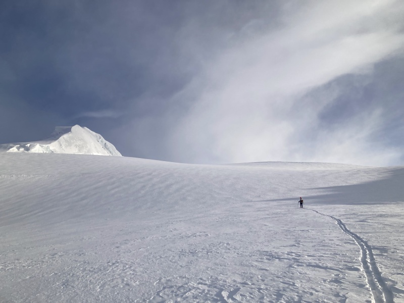
We were up and moving again by 7:00am the next morning. Up to this point, the upper mountain has been hidden behind a gentle roll near 10,500’. We eventually reach it and get our first good look at the summit and a confidence boost that we just might reach it. We also lose all protection from the oncoming wind, which is blowing at a stiff 25 miles per hour.
A few more low-angle miles take us to the base of what looks a whole lot like another mountain sitting on top of the one we have just climbed. Here the route steepens again, but it never exceeds 35 degrees and I have no trouble skinning. At one point I tried to put on my ski crampons, but I couldn’t get them on without taking off my skis off, so I gave up and kept moving up.
We trudge along for hours; It’s too cold to stop for long. At 15,000’ we walk into a cloud that has been hanging around the summit, but the sun is trying hard to break through and gives everything an odd yellow and orange tint that makes it feel like we are climbing on another planet. The wind picks up to at least 30mph and bites at my covered face. I start to regret not buying the fancy new balaclava that I was looking at the night before we left. It seemed ridiculously expensive and unnecessary at the time; not so much right now.
The Summit is Finally in Sight!Wind Carved Terrain above 13,000'High on the Mountain, Trying to Avoid Getting Blown Off
Around 16,000’ a monster crevasse marks that we are nearly to the top. A gentle slope leads another quarter mile to the summit. Finally, at 4:55pm – 5 minutes before our agreed upon turnaround time –we were standing at 16,237’ on the summit of Mount Sanford. The thermometer says it is -25 degrees out, combined with 30+ mph wind and the wind chill is deep into the -50s.
We didn’t stay long. Ten minutes to rip skins, mess with boots, take a few bad summit selfies and we click in. The top 2000’ is sculpted by wind and we ski carefully through the clouds, following what remains of our skin track and flags. After that the snow quality improves and we descend quickly into the thicker air and back to camp. I look at my watch; it took us 10 hours to climb 7,500’ and just 1 hour and 10 minutes to descend.
The Summit of Mt Sanford is a Large, Barren Plateau. The Point We Stopped at Seemed to be as High as Anywhere Else. Wish I had more Pictures from the Top But Happy to have All of My Fingers Instead!Flags, Bits of Skin Track, and a GPS Breadcrumb Track to Make Sure we Didn't Ski off of the Wrong Side of the Mountain. The Other Sides Aren't so Gentle
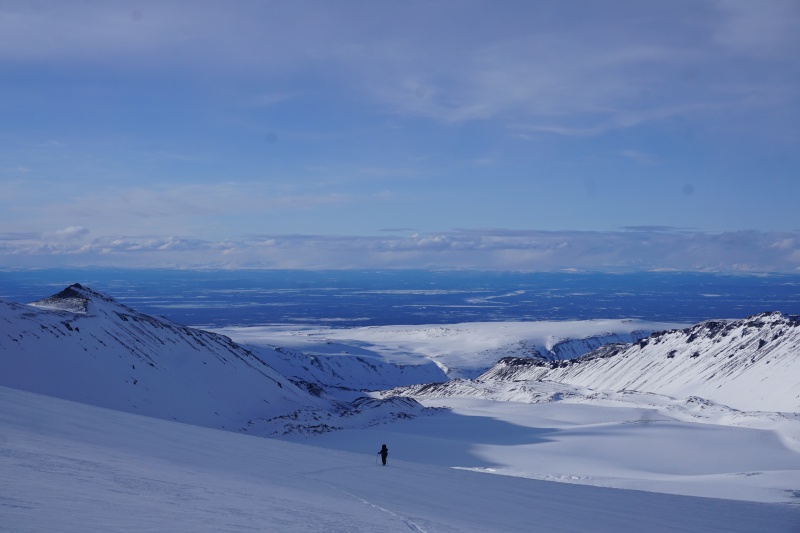
We quickly packed up camp and drop anther 4500’ to our sleds. The light is flat and skiing with heavy packs through the crevasse field is tricky, but we are still off the glacier in less than an hour. Packs go into the sleds, and we push a few more miles down to Boulder Creek in search of the nearest flowing water.
Fortunately, the 25 miles back to the car the next day are not quite as flat as I remembered on the way in, and we made it back with daylight to spare.
Beta is fairly limited on remote Alaskan peaks like Sanford, but as far as I can tell this was only the third human-powered climb of the mountain: the first being the first ascent by Bradford Washburn & Co in 1938, and the second a 16-day solo effort by Dave Johnston (of Minus -148 Degrees fame) in 1984. Also, at 19 years old I would plug Ben as likely the youngest to summit, but who knows. EDIT: After posting, I heard of at least 2 other groups that did this climb from the road in the 1980s, their records apparently didn't make it onto the internet.
Overall, I found this trip to be quite physically demanding, but also a unique way to climb and ski a big Alaskan peak. While I don't necessarily recommend the walk in, the mountain itself was incredible.
Sun Set from Highcamp Before Our Summit Bid
My GPS Tracks on Google Maps (made from a .GPX file upload):
There's so much to like: an obscure and seldom-climbed summit, hardship, long days, and proper use of skis to cover serious ground. I'd never do something like this, because I lack the gear and circulation, but I'm glad to hear about it getting done.
I can't even imagine doing such a long approach, especially given the air temperature and wind speed. I feel spoiled in Colorado. Congratulations on a successful trip.
This is so awesome to read, well done guys! I was up Sanford last June with a fun group and we were all wondering how things are in March for a full value ascent from the road (we flew in to Boulder Creek). I'll say the same thing I have said before....immeasurable badassery right here!
Really enjoyed your report that included some intense challenges and dangers from exposure.
In summer 2017 I biked across the continent starting in Anchorage and given the cloud
layer had no idea that Mt. Sanford even existed. On the 4th day of my trip I arose
to it looming over my campsite in the central part of the state. Almost more
breathtaking than Denali and certainly more alluring given that it is not the center
of attention from the mountaineering community.
Appreciate the kind words! There was definitely a lot of type 2 fun, but that part is quickly forgotten. Temps were rough, but it was doable with the right gear. I'm still kind of amazed that it actually worked out.
Matt - I read your TR before we went and the pictures were super helpful, congrats on your summit as well! You didn't miss anything except misery by flying in haha
ncpaul - That sounds like a badass trip! It certainly is an impressive mountain from very far away. I love how little attention some of these massively challenging Alaskan peaks get.
As soon as I saw this peak, I wanted to ski it! Never got the chance when I lived up there, but glad to see what it entails.
Caution: The information contained in this report may not be accurate and should not be the only resource used in preparation for your climb. Failure to have the necessary experience, physical conditioning, supplies or equipment can result in injury or death. 14ers.com and the author(s) of this report provide no warranties, either express or implied, that the information provided is accurate or reliable. By using the information provided, you agree to indemnify and hold harmless 14ers.com and the report author(s) with respect to any claims and demands against them, including any attorney fees and expenses. Please read the 14ers.com Safety and Disclaimer pages for more information.
Please respect private property: 14ers.com supports the rights of private landowners to determine how and by whom their land will be used. In Colorado, it is your responsibility to determine if land is private and to obtain the appropriate permission before entering the property.


")
")
")
")
")
")
")
")
")
")
")
")
")
")


