| Report Type | Full |
| Peak(s) |
Mt. Rainier / Tahoma 14411' |
| Date Posted | 01/05/2022 |
| Date Climbed | 06/22/2019 |
| Author | dr_j |
| A Love Letter to the Cascades: Mt. Rainier |
|---|
|
Mt. Rainier via Emmons-Winthrop (6/20-23/19) For people like me who hate the outdoors, there’s this shoulder season in the Rockies, as the ski season winds down, and before summer hiking season starts. This coincides with the best time to head to the Cascades, with the longer days, glaciers nicely filled in, and some semblance of stable weather. I’m from the Pacific Northwest originally. I grew up with the great peaks of the Cascades visible on those rare clear days. From certain points in Portland, one can see Rainier, Adams, St. Helens, Hood, and Jefferson. They’re massive peaks that dwarf anything in Colorado in terms of vertical relief, scale, and get slammed by the Pacific storms in the winter. As a result, they get copious amounts of moisture, snow, and are notorious for bad weather. They’re also deadly siren songs, as they are visible to the millions of people living in the Portland and Seattle metro areas and are easy to get to. Not surprisingly, they see a disproportionate number of accidents, rescues, and deaths. Mt. Hood, in particular, was the scene of a 1986 climbing disaster that took the lives of nine mostly high school aged persons, kids barely older than I was. Mt. Rainier was the scene of the deadliest climbing disasters in US history- 11 climbers on Rainier’s standard route perished from an avalanche in 1981, and another six died in a nighttime ice / rockfall on Liberty Ridge in 2014. As big as they are, photos don’t do them justice. Viewed from Seattle, you are only looking at the top 4000 feet of Rainier. Hiking around Rainier is a 100 mile trek, and the easiest route up Rainier gains 9000 feet of elevation. At the same time, they are shy. The peaks are rarely visible due to low clouds and the gray skies of the Northwest, and the access roads are hidden deep among the tall trees of the forests, so they only reveal themselves up close. Snow-covered, they sometimes get mistaken for clouds, and appear mirage-like. On windy days, the tops of the peaks grow lenticular clouds that cap them like a UFO or a mushroom. The passes across the Cascades rarely exceed 5000’ above sea level, with none of the open views that you get in the Rockies, and it’s hard to even get a sense that you’re gaining elevation. Despite having these mountains in my backyard growing up, I almost never went to the Cascades. Outdoor activities were pretty far down the list, and in fact we rarely did anything more than day trips. I skied only a handful of times, and rarely hiked. My memories of the Northwest were primarily of endless rain and gray skies, and I rarely returned after finishing high school. I got a text back in early April 2019 from my friend Nick, who asked whether I might be interested in climbing Rainier and offered few specifics past that. I hesitated on this, since he’s about 14 years younger, a former mountain guide who was a whole lot more experienced on all things outdoors from skiing to climbing to rafting to biking. I doubted that I was going to be in any reasonable physical condition to do something like that. But still, I viewed it as a challenge to get into a condition where I would not be too much of a burden on the rest of the group, which ranged in age from 25-32. So for the next few weeks, I hit up the closed ski areas nearby, and would hike up, and ride down on my snowboard. I’m fortunate to live near peaks that go up to 13000 feet, and so I would do this on weekends. But beyond that, I didn’t know a whole lot about what I was getting into, let alone have any experience with moving around on living rivers of rock and ice. I did not own any of the equipment, and only a few weeks before the trip, I plunked down four figures on a pack (55 L), ice axe, harness, boots, poles, and other climbing gear that I had no idea how to use (carabiners, crevasse rescue device, some rope). I’m a summer hiker, so I never use that stuff. I don’t rock climb, either, and I can’t tie a knot to save my life. I hate the outdoors. The last bit of training was a ski descent of Shavano, which actually turned out to be similar to summit day on Rainier. We hiked up the Angel of Shavano, and with the good snow year in 2019, were able to ski down about 2700’. We also carried about 25-30 pounds of ski gear and supplies up above 14000’. I had just returned from a trip to the Stans, jetlagged, suffering from food poisoning for most of the trip, and had caught a cold. Finally I dropped the $$$ on a plane ticket to Seattle, and committed to the trip about a week before the departure date. The plan was to go up via Emmons Glacier, and it would be a group of six of us. Nick, who led the trip, had been up Rainier several times, and was an accomplished skier and climber. Matt was incredibly athletic, with superhuman endurance. Josh had climbed Denali. And the two youngest members of our party, Cody and Alex, both in their mid-20s, were very experienced outdoorsmen equally at home on a trail, a bike, rafting rapids, or snowboarding expert terrain. I will say that I still felt like a bit of a burden on the other five people, and really hesitated until the last minute. The NPS guide describes the route as being 9-10 miles one way, with an elevation gain of 10,300 feet. To put that in perspective, that's a lot of gain even by Colorado standards, and that's more vertical relief than 37 states. Emmons receives about 10 % of the climbers attempting Rainier, and is one of the easier and less technical routes. There are none of the stakes and ladders that mark the Disappointment Cleaver route on the south side, and it's considered to be a more pristine, quieter experience. I flew into Seattle on 6/20/19, landing on a muggy, overcast day in the Emerald City. It’s rather incredible how much stuff needs to be packed, I probably had 40 lbs, my friend who was leading had the ropes and his stuff must have been 80 lbs. And then there was still all the food and supplies that needed to be bought. We did that after escaping the Seattle traffic, going on a shopping spree in Enumclaw, followed by a beer and a crappy sandwich. By the time we had made it to the trailhead, it was raining and overcast, just like the Northwest of my youth. We spread out all the stuff in the parking lot, and picked through each item. It’s one of those situations where I was absolutely clueless about what to do, how to pack, how much to pack, and somehow I didn’t feel like an adult. I always figured that I would forget something, or be really behind and plead for help packing properly. It was an awkward, unbalanced mess of stuff on my back. 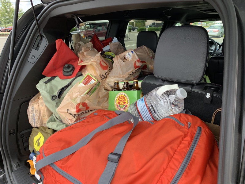
Eventually, though, we were on our way, and the first steps with 50 lbs on my back were utterly painful. Lifting it onto my back was enough of a task, let alone having to haul all this stuff up nearly a vertical mile. We got going at 8 PM, and the rain did let up enough to finally show The Mountain in all its glory about an hour later. Were we really going to try to climb that? 
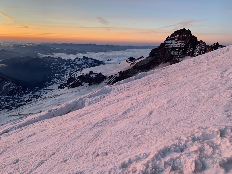
We got to the campsite around 10 PM near the end of the formal trail, and set up camp on a patch of snow, the first of what would be three nights sleeping on snow. The following day was pretty leisurely, as we woke up late, took in a slow breakfast, and were all pretty happy that the sun came out and that the weather would be stable for a bit. Now the upper mountain was another matter, but it was mostly smooth sailing for the trip up another 3000 feet to Camp Schurman. We followed mostly social trails until we had to get on the snow, and in the last flat spot before the start of the Inter Glacier, we roped up. I just let Nick do the knots and such, as I would have been hopeless. I had enough trouble strapping on my borrowed crampons, and they just kept coming loose during the trip. We went as two rope teams of three persons each, I was in the middle between the two fastest members, and we arrived up at Camp Schurman just before 3 PM. Our other rope team arrived about 90 minutes later, and we spent the next 45 minutes scoping out a spot to camp and started digging a wall to keep out the wind. Most of the route was visible from the camp, marked by a trail of footsteps that made its serpentine way up and around the numerous obstacles. 

Now the sunset was really something else, really spectacular, and that temperature dropped quickly after the sun went down. Despite getting into bed by around 9:30, it was hard to fall asleep as expected, as I still got cold, and this reminded me why I hate the outdoors (at least there were toilets up there). 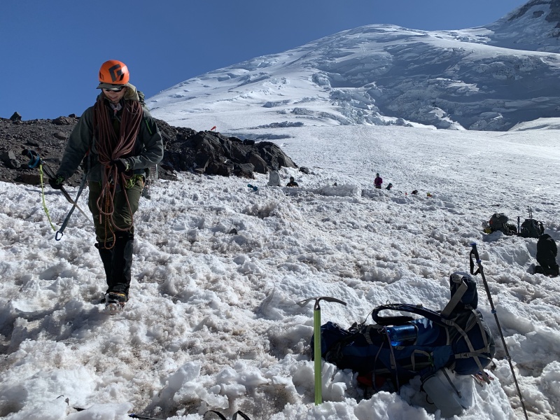
We had a 2:45 AM wakeup call for summit day but a few of us dragged and we didn't get going until nearly 4:30 AM, much to Nick's annoyance. Plus Josh had fallen ill with a stomach bug, and we were now a single rope team of five. Overall, I found it to be less taxing than the previous day, mostly because we were carrying much lighter packs of ~20 lbs. I had my moments of fading energy, nearly falling asleep halfway up, before I was offered a Thermos of coffee. Alex complained of being cold and tired. But the day was clear and we could not have hoped for a more ideal day to climb The Mountain. Going up was tedious and dull, and I was concerned with not tripping over myself since it was only the third time in my life using crampons. I recall very little of it, but the scenery really was truly special. After all, how many people in the world get to experience this up close and personal? 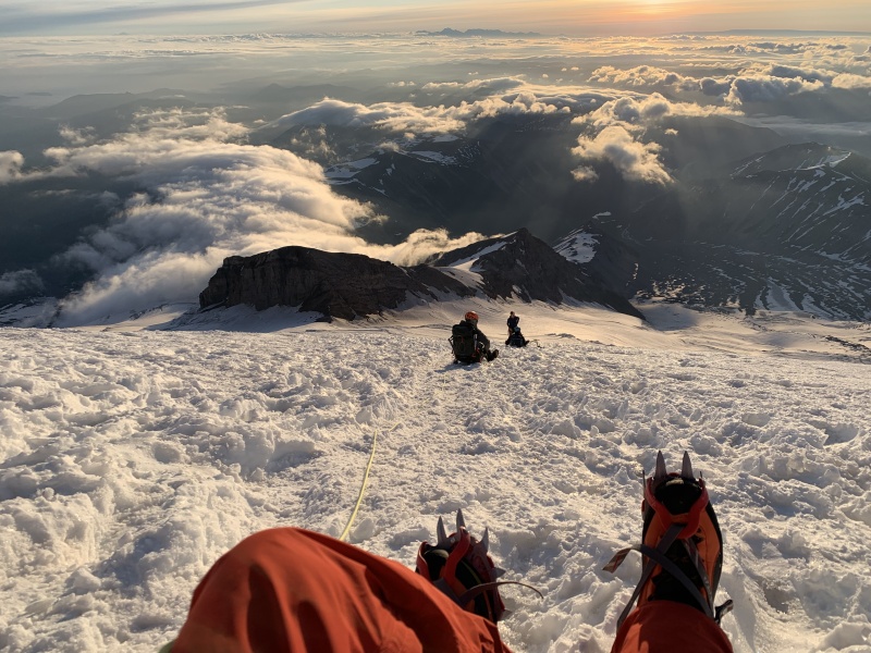

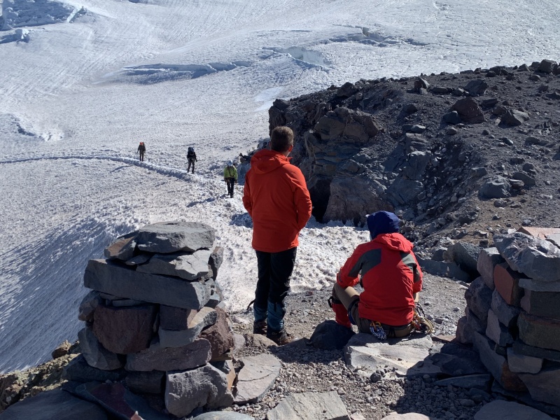
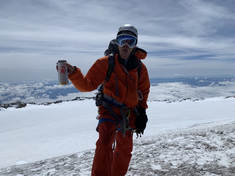
We unroped about 150 feet below the summit, as the snow gave way to just rock. It’s one of those Cascade surprises, this part is snow-free due to heat from below. Although Rainier has not erupted in a very long time, it is one of the most dangerous volcanoes in the US, and recent volcanic activity is evident everywhere in the Cascades. And there we were. I walked further south to the opposite side of the crater rim to take in the view of Adams, Hood, and St. Helens, snapped a few pictures before my hands and camera got too cold, took a quick walk to the true summit, and then chugged a Rainier beer. How lucky I was. 
We hustled down, and with our rather awkward rope team of five, I found myself jerked back and forth and was butt sliding more often than walking. We made it back to camp by around 2:30, and celebrated with a post-summit beer. Then we cooked dinner as the winds really cranked up, and beat a hasty retreat back to our tents. After packing up in the morning, it was literally all downhill from there. 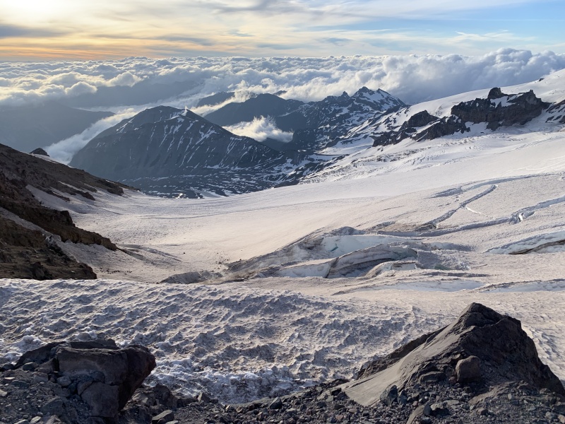
From the time we left Camp Schurman, it was three hours back to the car, by glissading down the Inter Glacier, and then jogging down the trail for the last three miles. In retrospect, we were all in excellent shape, no doubt having an advantage living at high altitude. We passed every party on the way up, even if Nick was getting a bit irritated at the frequent stops. We drove to the nearest diner / dive bar / lumberjack watering hole for a post-summit meal and beer, and we were back in Seattle metro in time to make our Sunday evening flight. I guess there’s something about six stinky, greasy guys in outdoor gear that is really attractive, as days later our server managed to track down the best-looking member of our party (not me) and ask for his number. And as for me, I was back at work Monday morning, sitting in the usual meetings and back to being a desk jockey. I guess after all this I hate the outdoors a bit less. 

Tips and random notes: The success rate for Rainier is about 50 %. I would say that most parties are physically prepared for the climb, but the fickle PNW weather makes summiting a crapshoot. We were very lucky with our weather window, the days on either side of our summit attempt were no-gos, due to either snow or winds. Then there’s all the other stuff The Mountain tosses at you, crevasses, rockfall, icefall, and for some, altitude sickness. Training: this one is hard to say. Hiking the higher peaks in NM proved to be more than sufficient for the aerobic aspect of the climb. I’d say that for something like this, decision-making and rope team management is key. We were a five member rope team due to Josh becoming ill at Camp Schurman, otherwise it would have been two groups of three persons. Unfortunately, we all went at different paces ranging from being very fast (and impatient) to being on the slow side (me). It is also difficult to effectively communicate over the ~100 feet between the front and back. We had never climbed together in this kind of setting prior to this trip. Also, keep in mind that you’re likely to be functioning on a sleep deficit and during hours where you’re normally going to be asleep. The long summer days made headlamps only necessary for the first hour or so. Thumbnails for uploaded photos (click to open slideshow): ")
")
")
")
")
")
")
")
")
")
")
")
")
")
")
")
")
")
")
")
")
")
|
| Comments or Questions | |||
|---|---|---|---|
|
Caution: The information contained in this report may not be accurate and should not be the only resource used in preparation for your climb. Failure to have the necessary experience, physical conditioning, supplies or equipment can result in injury or death. 14ers.com and the author(s) of this report provide no warranties, either express or implied, that the information provided is accurate or reliable. By using the information provided, you agree to indemnify and hold harmless 14ers.com and the report author(s) with respect to any claims and demands against them, including any attorney fees and expenses. Please read the 14ers.com Safety and Disclaimer pages for more information.
Please respect private property: 14ers.com supports the rights of private landowners to determine how and by whom their land will be used. In Colorado, it is your responsibility to determine if land is private and to obtain the appropriate permission before entering the property.

