Download Agreement, Release, and Acknowledgement of Risk:
You (the person requesting this file download) fully understand mountain climbing ("Activity") involves risks and dangers of serious bodily injury, including permanent disability, paralysis, and death ("Risks") and you fully accept and assume all such risks and all responsibility for losses, costs, and damages you incur as a result of your participation in this Activity.
You acknowledge that information in the file you have chosen to download may not be accurate and may contain errors. You agree to assume all risks when using this information and agree to release and discharge 14ers.com, 14ers Inc. and the author(s) of such information (collectively, the "Released Parties").
You hereby discharge the Released Parties from all damages, actions, claims and liabilities of any nature, specifically including, but not limited to, damages, actions, claims and liabilities arising from or related to the negligence of the Released Parties. You further agree to indemnify, hold harmless and defend 14ers.com, 14ers Inc. and each of the other Released Parties from and against any loss, damage, liability and expense, including costs and attorney fees, incurred by 14ers.com, 14ers Inc. or any of the other Released Parties as a result of you using information provided on the 14ers.com or 14ers Inc. websites.
You have read this agreement, fully understand its terms and intend it to be a complete and unconditional release of all liability to the greatest extent allowed by law and agree that if any portion of this agreement is held to be invalid the balance, notwithstanding, shall continue in full force and effect.
By clicking "OK" you agree to these terms. If you DO NOT agree, click "Cancel"...
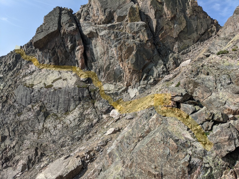
This is Roach's Holy Cross 5V2. I'd recommend it for the fit on a day with little chance of lightning: It's a beautiful tour of the area, but it's a long day over a lot of talus, and you're on an exposed ridge for many, many miles. It's slightly more difficult than the standard Halo Ridge->North Ridge route (class 2+, 5800', and 12 miles [per Roach, my GPS showed 6000' and 14 miles] vs class 2, 5400', and 13 miles) and includes the summit of Notch Mountain, which provides sweet views of the cross face. For what it's worth, on routes that aren't pushing my comfort limits, I really enjoy climbing off sparser descriptions like Roach's. It's more of an adventure than the step-by-step instructions this site provides, though of course there are times I've been very grateful to have the detailed descriptions Bill puts out. That said, if you want a little more detail on this awesome route, I thought I'd share my gpx and a photo of the route's crux.
After descending off Notch's summit, you have to get around the notch, where the route finding is tricky and the terrain can get, and especially look, difficult. The photo shows the route I took, best I can remember yesterday. The gully is the big one coming down from the notch. I didn't descend as much as I thought I was going to have to, never got down to 12,900'. To get over the cliff band after the gully I did a lower fifth class move with zero exposure, but there are probably other ways through. The horizontal shelf under the lung-looking cliff is exposed but wide enough to walk normally through and wasn't at all unnerving for me. The scrambling after is that straightforward. Around the end of what this photo shows takes us to the next photo...
The crux of the route: route finding below the notch.
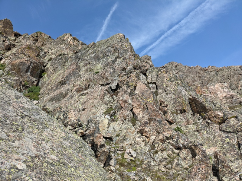
After the above terrain, it looked like you could continue an ascending traverse over class 2 talus; this is looking back and up to fun, solid class 3 scrambling direct to the next summit. Class 2 is my least favorite class, and there's a lot of it on this route. I highly recommend this way up.
Third class option to the summit after the notch.
Overall, a beautiful tour of Holy Cross, and since Notch is more visible from surrounding areas, it's a cool 13er to have summited. I'm glad I did it this way, but again be careful with this route... it's a long day over a lot of talus with 1000' of ascent on the descent. I wouldn't have wanted to do it on a bad weather day or if 6000' vertical were pushing my fitness limits. It was an eight hour day for me: 5:20 to the summit of HC; 20' on the summit; and 2:20 down. For perspective, I'm fast but not the fastest; did Longs' Radical Slam a few weeks ago, and that pushed my limits. Strava link here; gpx attached. I hope this is helpful.
My GPS Tracks on Google Maps (made from a .GPX file upload):
after Notch's summit. If you dropped to the west side of the ridge instead of east, there is a trivial climbers trail leading to a class 2+ , maybe easy class 3 gully that drops you back on the ridge crest. What you did looks way more scary, but I like the adventurous spirit! Here is my Strava if you or others want to compare lines south of the Notch summit
thanks for this note. just confirmed, roach says to "go around an unlikely corner on the west side of the ridge". the path i took wasn't scary (for me, who's pretty easily sketched out by exposure, but quite comfortable on class 3 and 4), and i actually quite enjoyed it, but yeah, important to note that this isn't the standard route. thanks!
I would argue this should be the "standard" Halo Ridge route. Best views of Holy Cross from the actual Notch Mountain summit and a little bit more technical fun.
I went around the West side of ridge though, like eskermo.
There's another Trip Report on here somewhere that did the same that I was following (and Roach of course).
I totally agree that this is the most aesthetic route to Holy Cross. The view from Notch is great.
I had had trouble finding reports that consistently suggest either west or east side, but seeing all of the ones that go east and having gone west, I think it is clear that going west side around is clearly easier -- class 2+ or at most 3. I spent a bit of time staying right on the nose of the ridge but could just not find a place to get onto the top and had to climb back down to the notch. Compared to the excitement, the west bypass was deflatingly easy :-)
Caution: The information contained in this report may not be accurate and should not be the only resource used in preparation for your climb. Failure to have the necessary experience, physical conditioning, supplies or equipment can result in injury or death. 14ers.com and the author(s) of this report provide no warranties, either express or implied, that the information provided is accurate or reliable. By using the information provided, you agree to indemnify and hold harmless 14ers.com and the report author(s) with respect to any claims and demands against them, including any attorney fees and expenses. Please read the 14ers.com Safety and Disclaimer pages for more information.
Please respect private property: 14ers.com supports the rights of private landowners to determine how and by whom their land will be used. In Colorado, it is your responsibility to determine if land is private and to obtain the appropriate permission before entering the property.
")
")