Download Agreement, Release, and Acknowledgement of Risk:
You (the person requesting this file download) fully understand mountain climbing ("Activity") involves risks and dangers of serious bodily injury, including permanent disability, paralysis, and death ("Risks") and you fully accept and assume all such risks and all responsibility for losses, costs, and damages you incur as a result of your participation in this Activity.
You acknowledge that information in the file you have chosen to download may not be accurate and may contain errors. You agree to assume all risks when using this information and agree to release and discharge 14ers.com, 14ers Inc. and the author(s) of such information (collectively, the "Released Parties").
You hereby discharge the Released Parties from all damages, actions, claims and liabilities of any nature, specifically including, but not limited to, damages, actions, claims and liabilities arising from or related to the negligence of the Released Parties. You further agree to indemnify, hold harmless and defend 14ers.com, 14ers Inc. and each of the other Released Parties from and against any loss, damage, liability and expense, including costs and attorney fees, incurred by 14ers.com, 14ers Inc. or any of the other Released Parties as a result of you using information provided on the 14ers.com or 14ers Inc. websites.
You have read this agreement, fully understand its terms and intend it to be a complete and unconditional release of all liability to the greatest extent allowed by law and agree that if any portion of this agreement is held to be invalid the balance, notwithstanding, shall continue in full force and effect.
By clicking "OK" you agree to these terms. If you DO NOT agree, click "Cancel"...
TLDR: First time doing Longs, decided to do the Grand Slam combo but picked a less efficient route to still do the full Keyhole ascent. Weather held and a good time was had. Got a large but disappointing burrito on the way home.
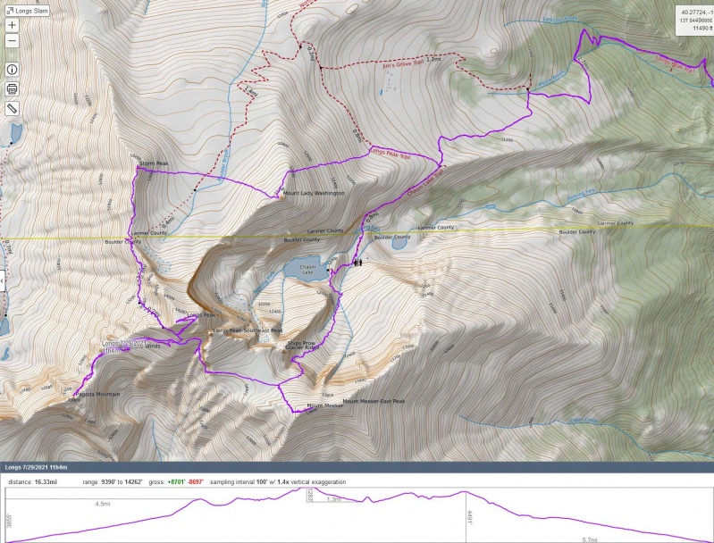
Stats: 16.3mi, 8,700ft vert, 11 hours 4 minutes
merrion13's trip report here has some info and links to additional TRs on the route with more detail. I used merrion13's .gpx file with some route modifications for my hike.
GPS track of my route, going counterclockwise
Longs was my last front range 14er and has been on my to do list since I moved here last fall, but I wanted to wait until it was fully melted out to be safe. Looking at the map and deciding the best way to do it I started adding peaks since they were nearby, then realized the Grand Slam route was a thing and decided that would allow me to get the most out of this trip. I still wanted to get the classic Longs experience of going up the Keyhole route, which meant reversing the typical direction and adding a little backtracking between Longs and Pagoda, but seemed worth it.
I arrived at the Longs Peak ranger station on Thursday a little before 5am (there are limits to how early I can get up!) and found the parking lot full and cars already parked quite a distance down the road. I got moving by headlamp, which was not needed for very long. I did my best to maintain a decent pace while on easy trail, trying to bank some time for the more difficult terrain that was coming up. The weather forecast for the day showed a modest chance of afternoon thunderstorms, so the backup plan was to at least do the first half of the route and keep an eye on the sky with the option of turning back without doing the full loop if needed.
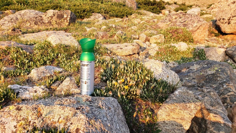
Breathing is important, but if you are already littering gift shop O2 cans at 11k I'm not sure you're gonna make it... I was going to back it out on the way back but somebody must have beat me to it because I didn't see it on the way down.
As I passed a group of three younger gentleman they started a short conversation. Despite one being cleverly disguised in a Colorado flag hat, their accents gave them away as Texans, which they confirmed when I asked where they were from. Certainly no judgement from me as a recent transplant, but it was kind of funny. We all find ourselves fitting into certain stereotypes at times and I'm no exception there! Anyway, they asked how I was "going so fast." This is sort of an awkward question because while it's all relative I don't think I'm particularly fast, and people asking these kinds of questions are usually looking for some kind of trick or shortcut that doesn't exist. They seemed kind of unsatisfied with my answer of exercising 4-5 days a week and that living in the front range helps with a head start on the altitude.
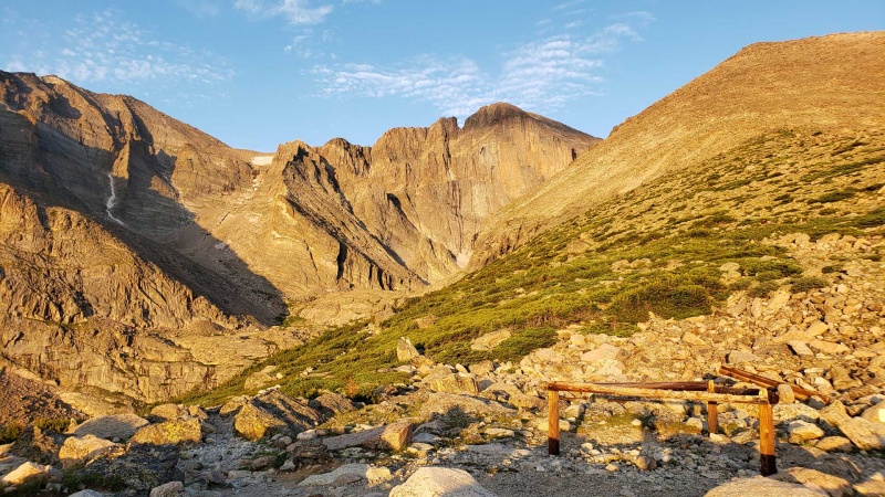
Sunrise on the face of Longs from the Chasm Lake junction
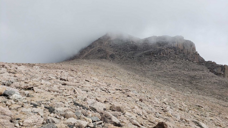
Leaving the trail shortly after the Chasm Lake junction I started up for the summit of Mt Lady Washington. It's a fairly steep slope, but luckily not too loose. The summit provides an excellent view of Longs and my first look at the Keyhole, where I could see a large number of people taking a break before starting on the Ledges. It also gives a clear view across the Boulderfield to Storm Peak and the ridge, my next destination. As a side note, the Boulderfield seems like a pretty unpleasant place to camp...
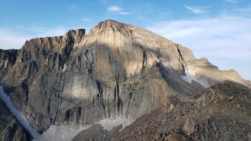
Longs from Mt Lady Washington summit
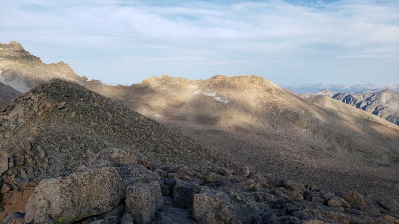
Storm and the ridge to the Keyhole from Mt Lady Washington
I took a direct line across to Storm Peak, which went quickly despite the constant boulder hopping. The ridge from the summit of Storm is short but I found it to be pretty fun. You can stay on the ridge proper almost the whole way without trouble and there are some nice solid rocks to hop around on. Shortly before the Keyhole I dropped down to the east side and reached the shelter to cross over to the Ledges.
Longs and connecting ridge from Storm
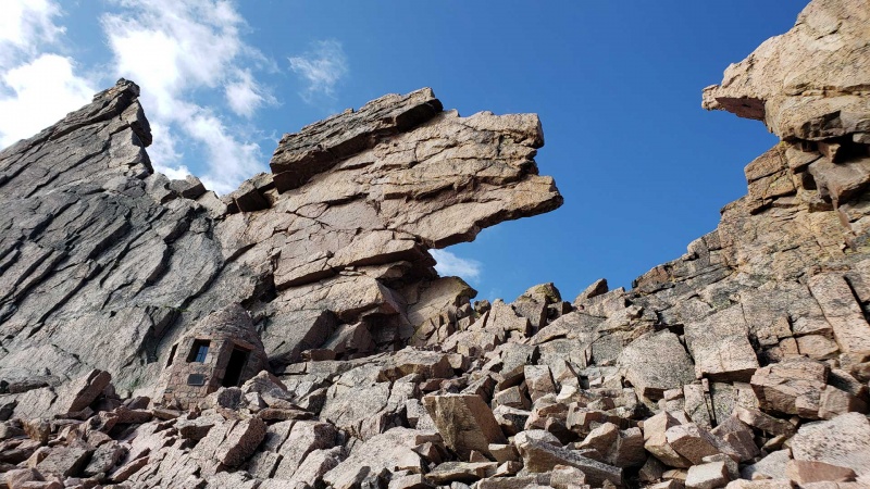
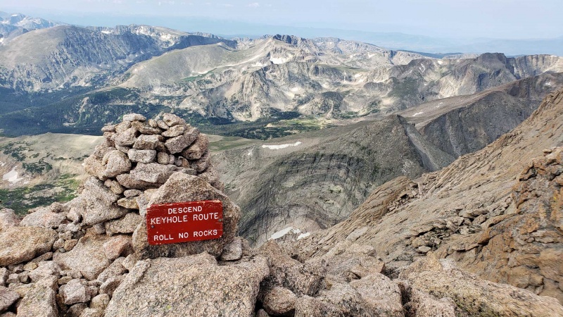
Obligatory Keyhole shot
The Ledges went quick and easy, but I can certainly see why it's the location of plenty of falls and several fatalities over the years, especially when there is any moisture or snow/ice. I was happy I waited until condition reports showed it was fully melted out for my first time. Route finding is pretty easy, but I'm a little surprised the faded bullseyes aren't refreshed more often given the popularity of the route. As a side note, I found this interesting review of deaths on the peak, updated March 2021. By the Trough the early birds were making their way down and from here to the summit there were some short waits here and there for safe passing. I was a little surprised to see at least 50% of people wearing helmets but it's certainly a reasonable choice given the possibility of rockfall and other hazards. I had considered bringing mine and ended up leaving it, but it's certainly a reasonable bit of gear for the route. I only saw two people in jeans, most people seemed pretty well prepared. The trickiest part of the Narrows was just getting around a guy with a camera set up to record himself going though, but he was very polite and friendly about it. Homestretch was a little congested, but it was fun to be on such solid rock for the first time all day.
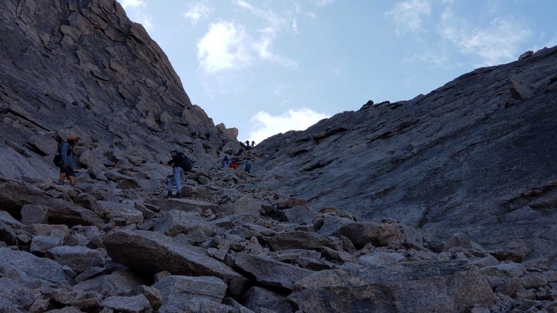
The early birds coming down the Trough
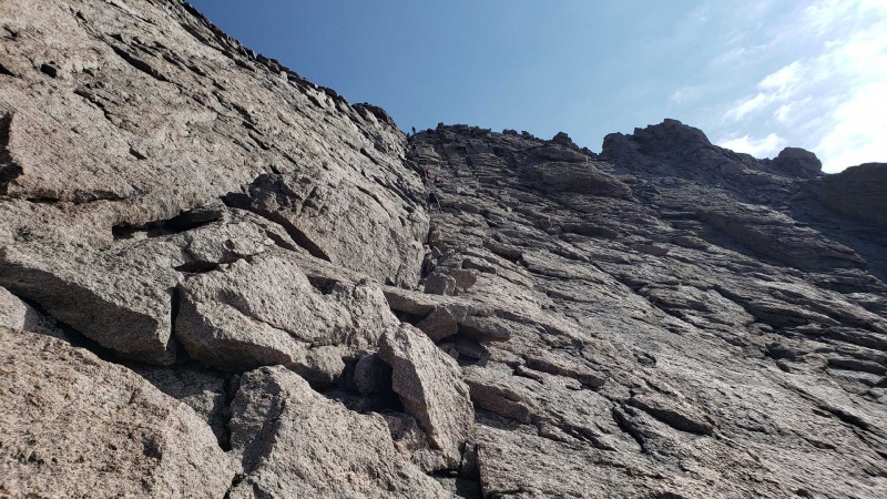
Heading up Homestretch
Views from the summit were excellent, with very little wind and only a few clouds in the distance. After a short break to eat and reapply sunscreen I headed down Homestretch, passing a mother and young daughter (10? 12? I can't guess kids ages) roped together, who I would run into again later.
Nice view from Longs summit looking SW
Right around the Homestretch/Narrows junction where I would be dropping down to work my way towards Pagoda I saw something red about 150' feet below that looked like a piece of gear that fell from the standard route. I was a little worried it might be gear still attached to a person, so I took a slight detour to check on it and happily found it was just a red painted wooden direction sign visible in some older trip reports. I tucked it under a boulder so others wouldn't see it and have the same worry I did. Getting from here to Pagoda is a bit of a hassle, crossing the slope while trying to stay at the right elevation to find the way through a big ledge. I did encounter a cairn or two but there isn't a super obvious line in this section and my pace was pretty slow. After initially overshooting, I eventually found the minor gully to get through the ledge, which was grassy and a bit damp, but pretty simple once you find it.
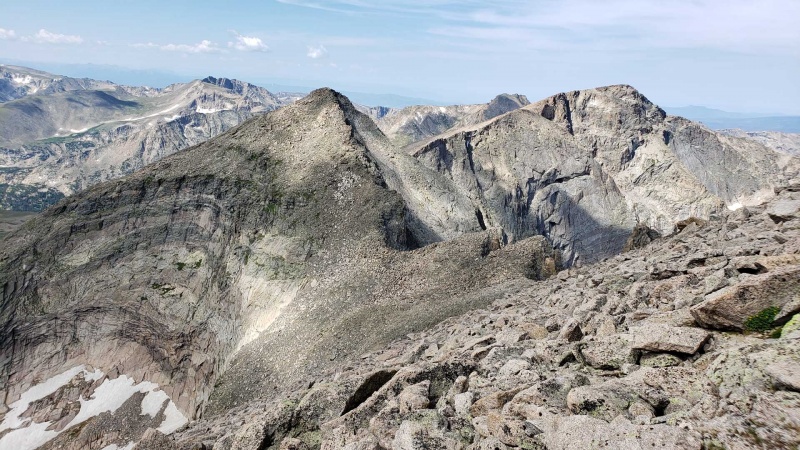
Ridge to Pagoda, with Chiefs Head Peak on the right
Once you reach the saddle the climb up to Pagoda is pretty short and direct. I had seen somebody on the summit from Longs, but not surprisingly had the place to myself when I arrived. From here you have a fantastic angle of Longs, the Palisades, the Loft, and Meeker that most people don't get. Some light clouds had also begun to gather at this point and while they didn't look too threatening I was glad to be past the halfway point and would keep my eye on them.
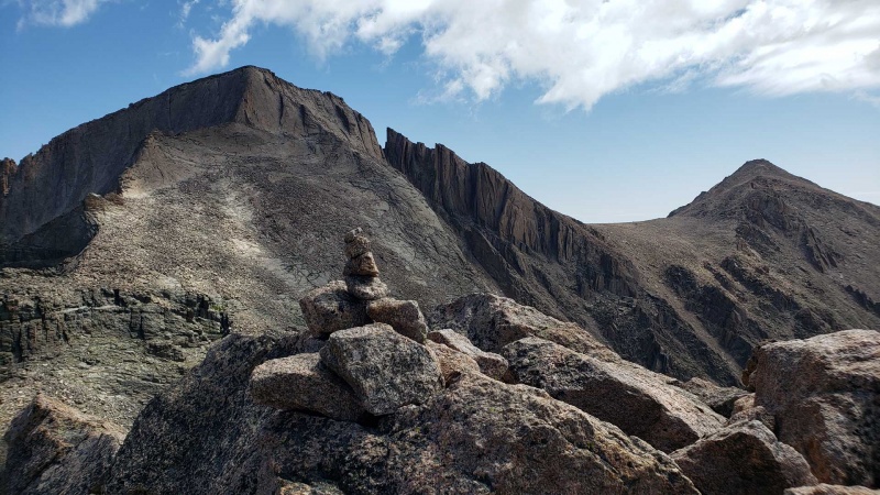
View from Pagoda summit
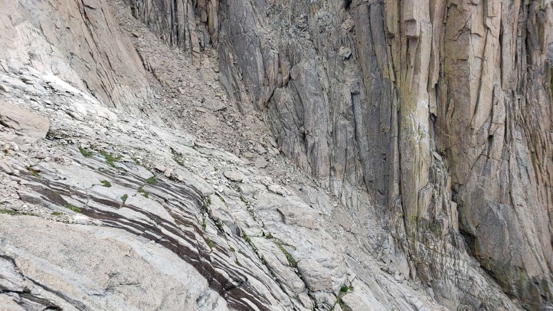
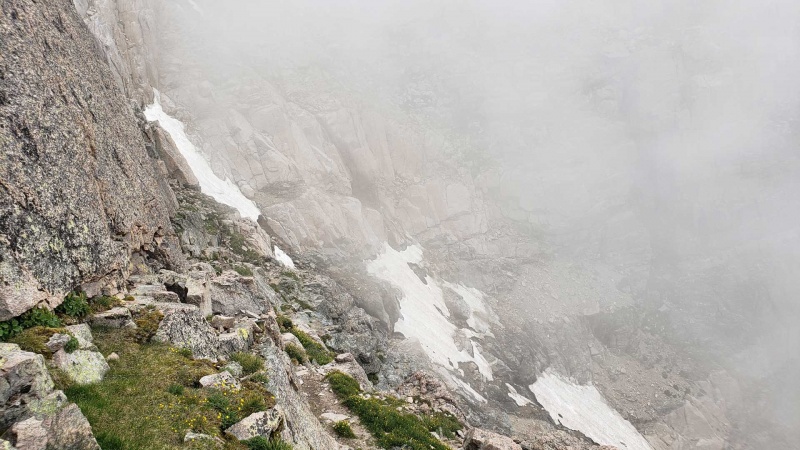
Backtracking to below the Homestretch/Narrows junction I was at least able to be a little more efficient the second time around. From here crossing into Keplingers was one of the slightly iffy moments of the route. The rock is sloped and smooth in places, with some minor runoff creating some traction issues. Luckily it's a short section and soon you are in the steep and loose (but unexposed) area at the foot of the Palisades. Here I descended too far, aiming for the wrong ledge system, but a GPS check (thanks technology!) allowed me to realize my mistake before too long and head back up for the right path to the Loft. I guess the Longs Easter egg of Clark's Arrow is in here somewhere and maybe I just walked right by it, but wasn't looking for it.
Crossing into Keplingers
Coming around the Palisades towards the Loft I spotted the roped up mother and daughter ahead of me and caught up to them in the final scramble of the section. I followed them and we chatted a bit, where I learned the daughter already has 24 14ers under her belt, with several times up Longs. Very cool! I told them of my plan to stop at a restaurant advertising a 20" burrito on my way home, which I think is an equal accomplishment. Once on the Loft the clouds were coming in and the summits of Meeker and Longs were hidden. They didn't look like rain, but I tried to pick up the pace so I could start heading down quickly. Meeker is unremarkable when there are no views to reward you, so I didn't spend much time up there. The ridge to East Meeker looked pretty cool when there was a bit of visibility, but I figured it was safer to stick to my plan and start heading down given that I couldn't see what the clouds above me were doing.
Meeker summit in clouds from the Loft
Descending Meeker in limited visibility I was basically relying on GPS to get down from the Loft, with a cairn here or there as confirmation. It's not the most pleasant route, but I can at least see the value in the directness. Here I passed the mother and daughter one more time and we wished each other well.
Loft descent in the clouds
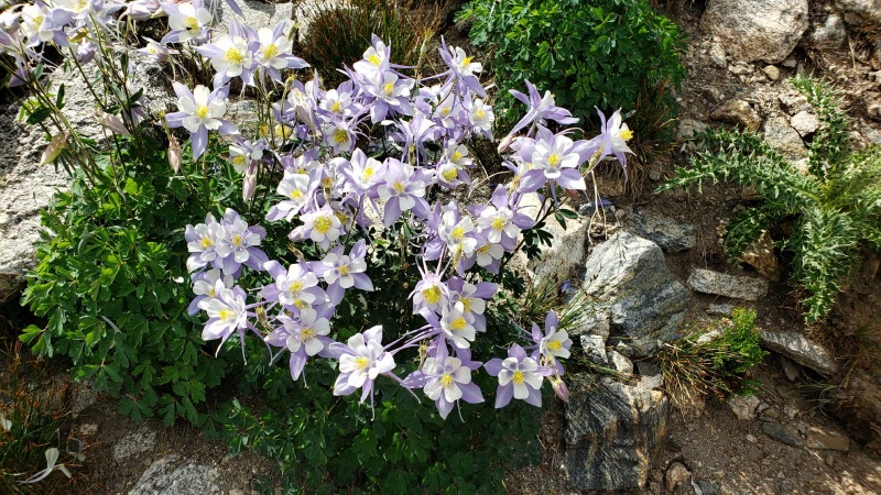
After making it down the loose slope the clouds partially cleared up, no rain or thunderstorms after all! After a short stop at Chasm Lake I was happy to rejoin a real trail and make some good time. This area is quite lovely with the small waterfalls and ponds as well as greenery including a ton of columbines.
Ships Prow
Peacock Pond
Nice bunch of columbines
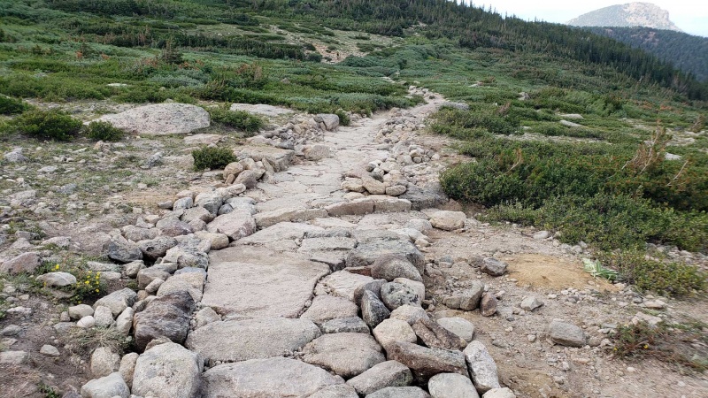
Some impressive trail building!
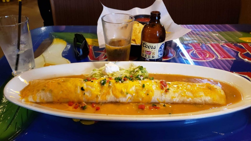
The rest of the way out went quickly and uneventfully, arriving back at the trailhead 11 hours and 4 minutes after I started. After a quick cleanup and clothing change at the car I headed to my planned dinner location and ordered a Coors Banquet (not the time to be classy) and the 20" burrito with chicken. Unfortunately while the service was quick, the burrito was quite disappointing, with mushy shredded chicken and bland green chile. It still filled me up at least, and I ate 80% before boxing up the rest for a snack later in the evening (food is still food after all). Rather than throw the specific restaurant under the bus, I will instead recommend an alternative giant burrito, the "Don Poncho" I ate back in January at Alfonso's in Colorado Springs.
Big but mediocre at best
A little bummed about the burrito but otherwise a fantastic day. A great first experience on Longs with a fun and demanding route.
I was up there the same day as you, planning on a variation of the grand slam that took iron gates up meeker and added Estes cone, but my partner was super beat after longs. Nice work!!
Since it was my first time up there I didn't have all the features sorted out in my head and totally thought the Loft route went through the Iron Gates. A little bummed to realize that wasn't the case since they look so cool but I'll just have to go back!
ltlFish99 - I'm not much of a photographer, but RMNP looks good naturally and every one in a while I push a button at the right time!
stuckinindiana - Yeah, I need to keep looking for a good spot in that area. Being hungry moved it one point up the scale, but that was still just a 5/10! Glad you enjoyed the report.
Well done! Bummer on the burrito though, but always the next time...
Caution: The information contained in this report may not be accurate and should not be the only resource used in preparation for your climb. Failure to have the necessary experience, physical conditioning, supplies or equipment can result in injury or death. 14ers.com and the author(s) of this report provide no warranties, either express or implied, that the information provided is accurate or reliable. By using the information provided, you agree to indemnify and hold harmless 14ers.com and the report author(s) with respect to any claims and demands against them, including any attorney fees and expenses. Please read the 14ers.com Safety and Disclaimer pages for more information.
Please respect private property: 14ers.com supports the rights of private landowners to determine how and by whom their land will be used. In Colorado, it is your responsibility to determine if land is private and to obtain the appropriate permission before entering the property.


")
")
")
")
")
")
")
")
")
")
")
")
")
")
")
")
")
")
")
")


