Download Agreement, Release, and Acknowledgement of Risk:
You (the person requesting this file download) fully understand mountain climbing ("Activity") involves risks and dangers of serious bodily injury, including permanent disability, paralysis, and death ("Risks") and you fully accept and assume all such risks and all responsibility for losses, costs, and damages you incur as a result of your participation in this Activity.
You acknowledge that information in the file you have chosen to download may not be accurate and may contain errors. You agree to assume all risks when using this information and agree to release and discharge 14ers.com, 14ers Inc. and the author(s) of such information (collectively, the "Released Parties").
You hereby discharge the Released Parties from all damages, actions, claims and liabilities of any nature, specifically including, but not limited to, damages, actions, claims and liabilities arising from or related to the negligence of the Released Parties. You further agree to indemnify, hold harmless and defend 14ers.com, 14ers Inc. and each of the other Released Parties from and against any loss, damage, liability and expense, including costs and attorney fees, incurred by 14ers.com, 14ers Inc. or any of the other Released Parties as a result of you using information provided on the 14ers.com or 14ers Inc. websites.
You have read this agreement, fully understand its terms and intend it to be a complete and unconditional release of all liability to the greatest extent allowed by law and agree that if any portion of this agreement is held to be invalid the balance, notwithstanding, shall continue in full force and effect.
By clicking "OK" you agree to these terms. If you DO NOT agree, click "Cancel"...
This is my first trip report on 14ers.com, so bear with me... it may not be the best.
At 14 years old, I am working very hard to finish the 14ers before starting high school. Also, I have started climbing some of the Centennial thirteeners, in hopes to be the youngest person ever to climb Colorado's 100 highest peaks. Does anyone know who the youngest is?
Regardless, one of the peaks I had been a bit nervous for was Ice Mountain. I have done about all of the 14ers (all but North Maroon and Pikes), so I certainly have some experience scrambling, but somehow Ice seemed really intimidating to me. The crux chimney looked steep and exposed and the rock quality poor.
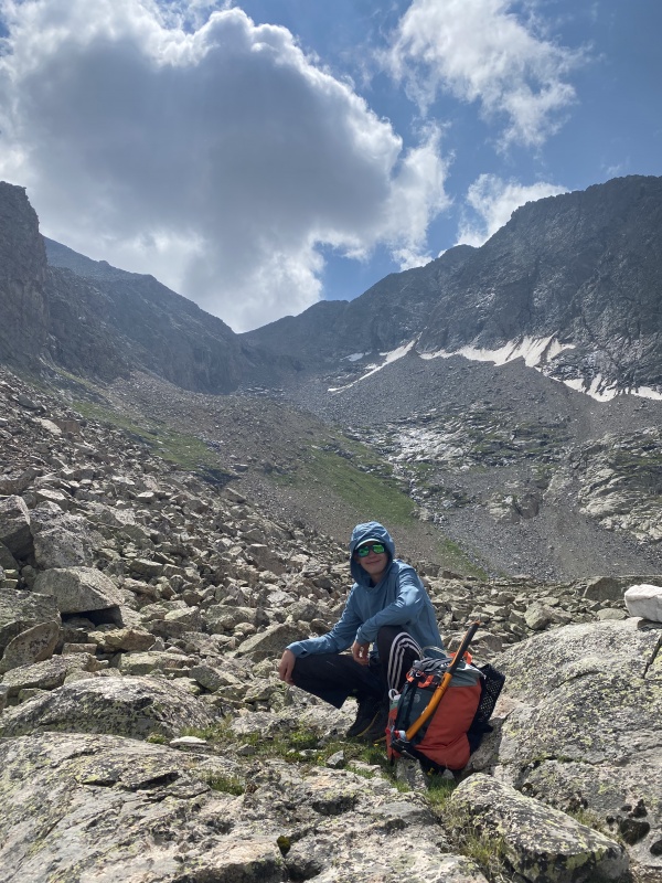
We left friday afternoon (23rd of July), and along the two hour drive rain hammered us relentlessly. In places I-70 was flooded, and I believe Glenwood canyon was closed due to a large muslide. We turned off of the highway, and began our way along clear creek. There was evidence of rockfall and large scale flooding. It was still raining lightly. We camped near Clohesy lake, and it rained for most of the night. Saturday we climbed Missouri Mountain, Iowa Peak and Emerald Peak. Around 8 am ( just passing over the saddle between Iowa and Emerald) heavy fog moved in, and it rained for about an hour. We descended back down to the main road, then drove to the Huron peak/Lake ann trailhead, and started drying out gear in a nice campsite a quarter mile northwest of the TH. We planned to climb North Apostle and Ice Mountain the next day.
Quick facts: Distance: 9.4 miles Vertical Gain: ~4k Time: 8:10
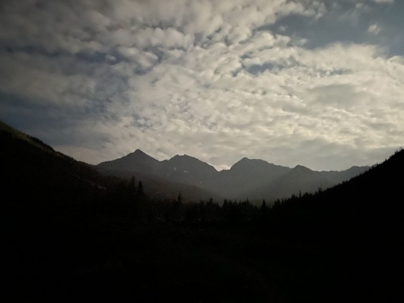
Night mode on the iPhone 11 Pros is so weird.
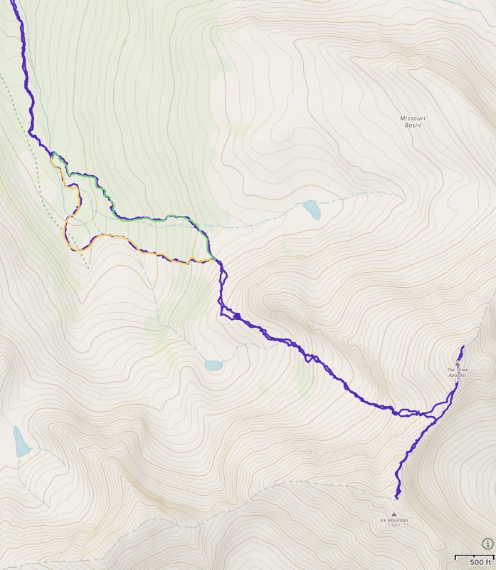
We started hiking down the lake ann trail around 4:30. A gentle pace brought us to the Hamilton Townsite after ~22 minutes.Left turn onto the Three Apostles Trail, then another 20 mins to the trail's end in a large meadowy area and some nice campsites, between the two forks of south clear creek in the upper basin. After the recent rains this entire area was flooded. We crossed west through the swamp, and hopped over the west fork of the east fork of the south fork of clear creek (haha... the creek on your right when you are going up valley). We then traversed all the way back around left. On our way down, we went immediately right and descended through the forest east of the swamp, then came back into the trail lower. There were fragments of trails here, and I highly recommend using this route, although it is very hard to locate where best to turn off, especially in the dark. The following directions should help you find this far superior route: Follow the three apostles trail as it climbs gently, to the west of the east fork of the south fork of clear creek. the trail breaks out of the trees in a large flat meadow. Follow it through the meadow until it comes to the creek. Cross the creek on rocks (where the trail brings you to), or at high water on a log 150 feet upstream (requires bushwhacking). The important thing is to turn left and follow a trail that initially heads northeast, not the more major one that goes southwest. this trail was very wet when we were on it, but the valley had just received 3+ inches of rain, so I dont think it normally is. Follow this trail as it weaves through willows, until a small rocky outcrop is on your left. It has some trees growing on it. Turn left and head east until you reach the edge of the forest. You want to cross uphill of the rock. Follow the edge of the trees south until reaching a small side creek, and a forested hillside with granite slabs. A strong use trail develops around this point. Follow it east directly up the fall line, then southeast until you break out of the trees on a small boulder-field-covered shoulder. That was easy... Now climb 150 vert along the boulders, then traverse southwest, bypassing the large, north facing cliff band on its east side. Plentiful cairns will guide you across the large, broad ramp, until you reach a point with a view of the tarn Roach describes. The route finding finally ends. we had a really nice time hopping up incredibly stable boulders to the saddle between North Apostle and Ice Mountain at 13,460. A cliff band in the basin is easily bypassed in a gully on the east side. We reached the saddle at 7:00 am, 2.5 hours from the car. The swamp did not save us any time.
Yellow is the way we took up. Green was our way down.Log crossing of east fork of south fork of clear creek. The trail visible heads southwest. You want the one that goes northeast for a few steps, because it will bypass the majority of the swampyness.
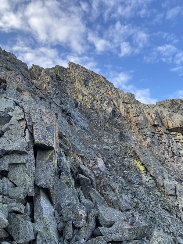
We took a nice break, then started up Ice's East ridge. Follow cairns and the very obvious trail around on the north side of the ridge to bypass the first fin, and reach the notch on the west side. Class 2 to this point. Continue up the ridge, always on, or slightly north of the crest. Encounter some fun but very easy 3rd class moves with nice exposure to your left. Rock quality is great to here.
Such quality rock. Sadly, it deteriorates as you gain elevation.
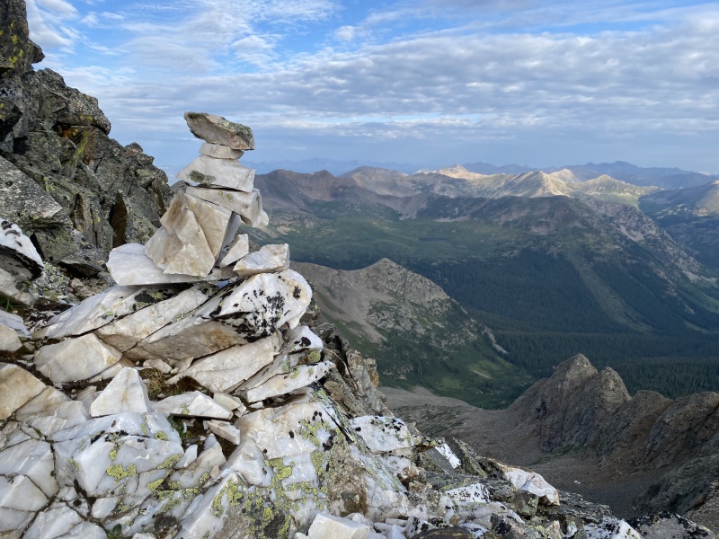
Really nice cairn built from quartz intrusion. The route finding is so easy on this route, with so many cairns.
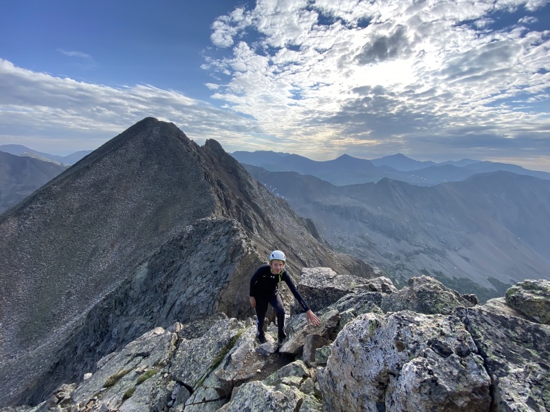
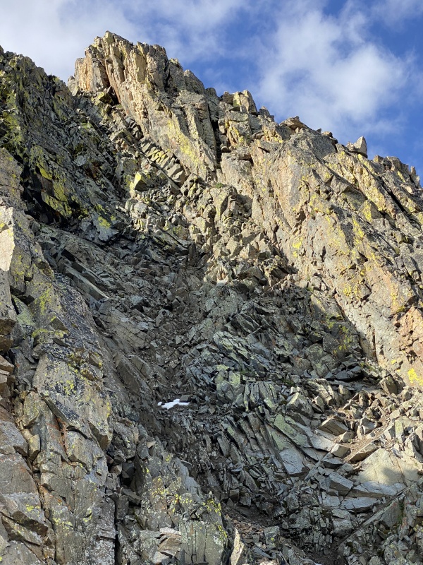
Continue along the ridge until it loses its definition and a rock step forces you onto the north face. Follow class 2 ledges with plentiful cairns around a corner, where the crux comes into view, all the way up into the steep rocky couloir.
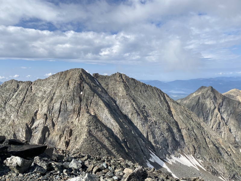
First good view of the crux. It is the gulley just left of the highest point visible.a view from before the crux, just before engaging the first, and only, real difficulty of the route.
By this point the rock has deteriorated from solid granite to fractured rock of some kind (not granite. I am no geologist.) When we climbed it, there was water in all the cracks, making the rock extraordinarily fragile. I would say the rock in the gulley is worse than that on Pyramid or the Bells. Carefully climb the couloir's west side. Roach calls it 3rd class. I feel that the hardest move is exposed 4th on bad rock. Possible alternatives are the chimney in the next gulley east ( I have heard that it is low 5th), or what caught my eye was the rib to the west of the standard gully. It looked like spectacular 4th on great rock. After down climbing the standard gulley, we felt no need to try the rib, but if I were to do Ice Mountain again, I would try it. I would appreciate if someone could provide beta on it.
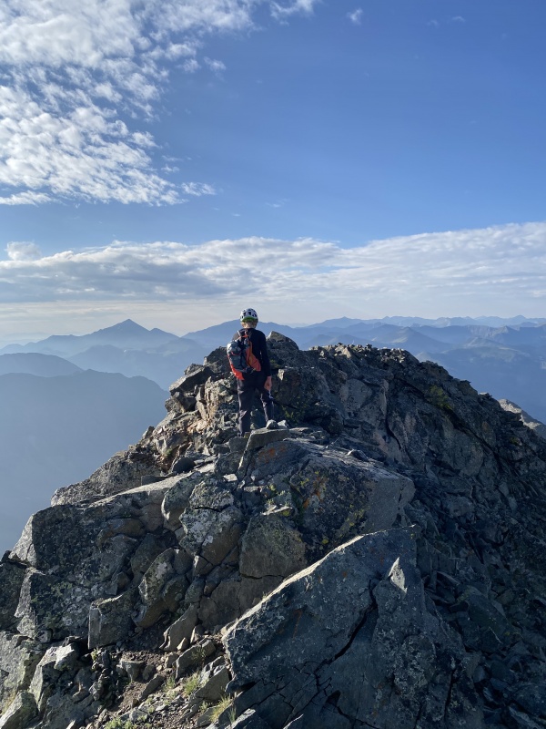
The summit is tiny. The view is spectacular.
After retracing our steps to the saddle, we darted up North Apostle. Even moving really slow it was only 12 mins from saddle to summit. The rocks are stable and movement is efficient. The summit is awesome, and the view to Ice is spectacular.
ice Mountain and West Apostle from the summit of North. The Refrigerator Couloir splits Ice's north face
We spent over an hour on the summit of North Apostle, watching curious pikas, clouds, and the incredible view out to Huron, Missouri, Belford, Oxford, Harvard, Columbia, Yale, Princeton, Antero, Shavano, Tabeguache, Cronin, Hope La Plata, Grizzly, Ice, Emerald, Lackawanna, Massive, Castle, Cathedral, Pyramid, Capitol, and a thousand others. What an amazing place!
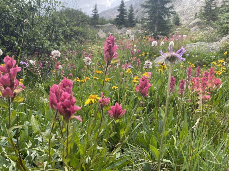
Above the little tarn, at the top of the ramp, posing with Ice MountainFlowers like rain.I love Rosies!
In all, an absolutely great set of peaks. My concern about Ice Mountain seems to have been uncalled for, but the crux chimney is every bit as difficult as advertised. If you are debating between two objectives, choose Ice and North Apostle. Well, unless capitol is on the itinerary. Then choose capitol. Or Maroon or Pyramid. I do love the elks.
Thumbnails for uploaded photos (click to open slideshow):
My wife and I took the lower 5th class chimney option that you mentioned. It is maybe 12 feet tall and doesn't have much exposure. Above that chimney it's just a class 2 to maybe 2+ walk to the summit.
I'm also 17 and have just about as many Cents as you. I've been curious as to who is the youngest finisher, and, through all my research, cannot find a definite answer. I've met a few younger climbers on this site and out in the mountains, but all of us are bound by our ability to drive (at least in order to climb). I'm aware that numerous children have finished the 14ers, but I doubt that stands for the cents as well (lots of harder approaches and peaks down in the wem would deter children, or parents from taking their children, but I could be wrong about that). I have yet to meet or hear of anyone under the age of 18 finish the cents, but it is a real possibility that there are a few out there. Under 16 though... it's possible, but as I said earlier, most of us are bound by our ability to drive. So take that for what it's worth. I'm trying to finish the cents this year, which would have me finish while I'm still 17. Best of luck to you and maybe I'll see you out there! PM if you ever need a partner.
Good job young man I reviewed your report thoroughly before my own attempt on Ice/Apostle yesterday. Unfortunately I had to orphan Ice since I took too long making my way up the endless rock fields. Wow you move fast 2.5 hrs to the saddle it took me 6! It was painful to leave Ice but my partner was justifiably concerned about driving down the terrible road in the dark when with a suspect vehicle. When I go back I will be sure to review your excellent photos. Best of luck in your pursuit of the Centennials and in finishing your 14ers.
Ice Mtn took me two tries. Both times I ended up crossing the upper couloir because it didn't seem to allow passage, from the way it looks from below.
The first time we were confused about where the summit actually was: the lower W summit has a big block boulder on its top which looked like a cairn from N. Apostle, so that was where we were headed. After crossing the W rib, as you call it, we got to the Ice Couloir, which was bullet-proof ice a week or so into July. Not having the necessary equipment to cross it we turned around there.
After further study and getting which was the true summit sorted out I went in solo four years later, backpacking into a camp at the base of the valley just S of Huron. This time was early September and all the ice in the Ice Couloir had melted out, but it was hardpack dirt and very difficult to ascend, being slippery and with no handholds. On the way across the rock rib, higher up than before, I ran across an old piton which easily pulled out of the crack in the rock it was in. From the top of the ice couloir, once I somehow made it, it was a simple boulder hop up to the top. While I was on the summit a man and his daughter made it up, more or less following the recommended route. They weren't eager to descend it, but I had a rope with me and we rapelled the upper part of the standard couloir on its W side, so I descended the "right" way. Not sure if I went up there a third time I'd be able to do it all correctly. This was a few years ago, so maybe all the cairns you followed were newer than when I was there. I don't recall there being any.
Good observation about the rock quality. I called it brittle. You'd think it was solid, but when you'd put your weight on it (i.e., for a foothold) it would suddenly snap off and break. As I recall there were fewer than 50 names in the register (near the end of the climbing season in September), so not many people make the summit of Ice Mtn. Kudos on doing it the first time.
Caution: The information contained in this report may not be accurate and should not be the only resource used in preparation for your climb. Failure to have the necessary experience, physical conditioning, supplies or equipment can result in injury or death. 14ers.com and the author(s) of this report provide no warranties, either express or implied, that the information provided is accurate or reliable. By using the information provided, you agree to indemnify and hold harmless 14ers.com and the report author(s) with respect to any claims and demands against them, including any attorney fees and expenses. Please read the 14ers.com Safety and Disclaimer pages for more information.
Please respect private property: 14ers.com supports the rights of private landowners to determine how and by whom their land will be used. In Colorado, it is your responsibility to determine if land is private and to obtain the appropriate permission before entering the property.


")
")
")
")
")
")
")
")
")
")
")
")
")